

ARCTIC: At the Cutting Edge of Climate Change
by Robert Glenn Ketchum

In 1993, I began traveling to the Arctic. I have been across The Northwest Passage by yacht; to the North Pole twice; to little-visited Russian islands; and aboard research vessels in Greenland, Labrador, Newfoundland, and Baffin Island, taking the opportunity to visit Iqualuit, the capital of Nunavut, the recently created Inuit nation and territories.
Wednesday, May 5, 2021
ARCTIC: At the Cutting Edge of Climate Change, #247
ARCTIC, #247:
This is the last post for this Northwest Passage blog. Appropriately, it is a map of our journey, compiled for us by Captain Jouning. As you will recall, our adventure began in Nome, AK, to the far left. Trying to avoid the pack ice, we hugged the coastline of the Alaskan North Slope and Canada, as we progressed. This blog recounts the many places, and villages, at which we stopped along the way. If you look carefully, you will see that shortly after our trip turns North, there are red dots. That marks the spot where “Itasca” became trapped in the ice of the James Ross Strait for several days. Once we freed ourselves, and turned East, we reached the coast of Baffin Island and dropped anchor at the town of Pond Inlet. It was here that Bill Simon commandeered a cargo plane and two pilots. who allowed us to join them for some flightseeing. Our plane visited some historic, locations, the town of Resolute, and then flew North to Eureka Base, where we spent the night. The next day we visited Otto Fjord, returned to Eureka to fuel up, and then headed back to Pond Inlet with an attempted stop at Grise Fjord that nearly killed all of us. It was a great privilege for me as a photographer to get to view this vast Arctic landscape, so I thank my shipmates for having me along, and I hope all of you think my photographs have done justice to a part of the world you might never see.
PINTEREST: pinterest.com/LittleBearProd
____________________________________________________
photograph(s) © copyright, ROBERT GLENN KETCHUM, 2021,
@RbtGlennKetchum @RobertGKetchum @LittleBearProd #LittleBearProd
Follow Robert Glenn Ketchum's Photographic Activism Online:
LINKEDIN: linkedin.com/in/RbtGlennKetchum
FACEBOOK: facebook.com/RobertGlennKetchum
FACEBOOK: facebook.com/NoPebbleMine.photos
TWITTER: twitter.com/RbtGlennKetchum
TWITTER: twitter.com/RobertGKetchum
SOCIAL MEDIA by #LittleBearProd: LittleBearProd
Wach Gallery: Wach Gallery
Wednesday, April 28, 2021
ARCTIC: At the Cutting Edge of Climate Change, #246
ARCTIC, #246:
When the villagers that live in this house saw me standing in the street making this picture, they came out and talked to me. I explained what I was doing, and they were fine with me photographing their home, so I asked what the smaller hut at the base of the stairs was, and the wife responded that it was her husband’s office, and that he had to walk to work everyday. Hahaha! Very tidy little property, with great views from the upper deck and windows of the home, and a dramatic red paint job that really makes the house pop out in the surrounding granite terrain.
PINTEREST: pinterest.com/LittleBearProd
____________________________________________________
photograph(s) © copyright, ROBERT GLENN KETCHUM, 2021,
@RbtGlennKetchum @RobertGKetchum @LittleBearProd #LittleBearProd
Follow Robert Glenn Ketchum's Photographic Activism Online:
LINKEDIN: linkedin.com/in/RbtGlennKetchum
FACEBOOK: facebook.com/RobertGlennKetchum
FACEBOOK: facebook.com/NoPebbleMine.photos
TWITTER: twitter.com/RbtGlennKetchum
TWITTER: twitter.com/RobertGKetchum
SOCIAL MEDIA by #LittleBearProd: LittleBearProd
Wach Gallery: Wach Gallery
Wednesday, April 21, 2021
ARCTIC: At the Cutting Edge of Climate Change, #245
ARCTIC, #245:
As I would learn later in my career all Inuit villages are decorated by a rainbow of hues. Most are also located in fjords, surrounded by granite domes, so houses are built on the domes, wherever a structure can suitably fit. As a consequence, there is a lot of up and down. There are usually roads, but most people choose to bicycle, or walk, therefore a complex of stairs connect all the homes and stores. The stairs often take you directly by someone’s home, but stairs are public domain for all to use, and homeowners do not seem to care. For me, they led to some fantastic overviews of the village, so I climbed a lot of them in this remarkable village of Kangerlussuaq.
PINTEREST: pinterest.com/LittleBearProd
____________________________________________________
photograph(s) © copyright, ROBERT GLENN KETCHUM, 2021,
@RbtGlennKetchum @RobertGKetchum @LittleBearProd #LittleBearProd
Follow Robert Glenn Ketchum's Photographic Activism Online:
LINKEDIN: linkedin.com/in/RbtGlennKetchum
FACEBOOK: facebook.com/RobertGlennKetchum
FACEBOOK: facebook.com/NoPebbleMine.photos
TWITTER: twitter.com/RbtGlennKetchum
TWITTER: twitter.com/RobertGKetchum
SOCIAL MEDIA by #LittleBearProd: LittleBearProd
Wach Gallery: Wach Gallery
Wednesday, April 14, 2021
ARCTIC: At the Cutting Edge of Climate Change, #244
ARCTIC, #244:
After several hours of the spectacular northern lights, my shipmates, and I, have all grown cold, and sober, so we collectively head indoors, have a nightcap, and toddle off to bed. “Itasca” arrives at Kangerlussuaq just before dawn and drops anchor. I have never been in an Inuit village before, so I am not quite sure what to expect, but when I wake for breakfast, and step outside to view this small town, I am amazed by how colorful it is. In the green, and grey granite, of the fjord, the houses of Kangerlussuaq sit on rock perches like sparkling jewels. Every color imaginable has been splashed across the landscape, adorning homes, stores, and offices alike. This looks like a very fun place to walk around, and since our jet will not arrive for some hours, we all have breakfast early, and go ashore to explore.
PINTEREST: pinterest.com/LittleBearProd
____________________________________________________
photograph(s) © copyright, ROBERT GLENN KETCHUM, 2021,
@RbtGlennKetchum @RobertGKetchum @LittleBearProd #LittleBearProd
Follow Robert Glenn Ketchum's Photographic Activism Online:
LINKEDIN: linkedin.com/in/RbtGlennKetchum
FACEBOOK: facebook.com/RobertGlennKetchum
FACEBOOK: facebook.com/NoPebbleMine.photos
TWITTER: twitter.com/RbtGlennKetchum
TWITTER: twitter.com/RobertGKetchum
SOCIAL MEDIA by #LittleBearProd: LittleBearProd
Wach Gallery: Wach Gallery
Wednesday, April 7, 2021
ARCTIC: At the Cutting Edge of Climate Change, #243
ARCTIC, #243:
Our destination in Greenland is the Inuit village of Kangerlussuaq, which has a sizable airport that is used by the military. It is there we will depart “Itsaca,” and Bill Simon’s private jet will pick us up, and fly us back to the United States. Kangerlussuaq is located at the end of the lengthy Sondre Stromfjord, so although we will reach the Greenland coast about nightfall, we will spend a good deal of the night motoring up the fjord. This will be our last dinner aboard, so of course, Bill plans a lavish one, and needless to say, the drinking continues unabated. About 9p.m. most of rise to stretch and stumble about, and a handful of us don our new polar fleece jackets, and head out onto the deck for some fresh air. The sky is dark, and cloudless, so the star show is spectacular, and as we all ponder the display, I ask my shipmates if there is anything else they might have wished for on this trip, and two of them said they had hoped to see the northern lights because they never had. I said I had seen them several times in Alaska, and they were an amazing spectacle. I was then asked to describe them, and before the words were out of my mouth, a shimmering multi-hued curtain, crackling with energy filled the sky above us, so I looked up and replied, “Oh, they look just like that!” For the next several hours everyone came out on deck, and watched one of the two best displays of northern lights that I have seen in my lifetime. When we arrive in harbor the morning, Bill flashes a V-sign to John Bockstoce - thank you John for this great picture of Bill.
PINTEREST: pinterest.com/LittleBearProd
____________________________________________________
photograph(s) © copyright, ROBERT GLENN KETCHUM, 2021,
@RbtGlennKetchum @RobertGKetchum @LittleBearProd #LittleBearProd
Follow Robert Glenn Ketchum's Photographic Activism Online:
LINKEDIN: linkedin.com/in/RbtGlennKetchum
FACEBOOK: facebook.com/RobertGlennKetchum
FACEBOOK: facebook.com/NoPebbleMine.photos
TWITTER: twitter.com/RbtGlennKetchum
TWITTER: twitter.com/RobertGKetchum
SOCIAL MEDIA by #LittleBearProd: LittleBearProd
Wach Gallery: Wach Gallery
Wednesday, March 31, 2021

ARCTIC, #242:
Before we reach the coast of Greenland, we have about 24hrs. of open-water travel in the Davis Strait of the Labrador Sea. Aside from ogling the occasional HUGE iceberg, there is little else to do except read, watch movies, workout, eat, and of course, drink. Everyone does the latter, so we are quite the happy crew by midday. We navigated south through the night, then began the crossing at first light, and we will arrive at the coast of Greenland about the time it gets dark again. It is a grey and misty day, but we are all pretty drunk, so no one cares. After lunch, Bill Simon surprises all of us with a commemorative gift - a polar fleece jacket sporting an embroidered design stating that we have been part of his Northwest Passage crossing. Of course, everyone then wants a group picture in the jackets, so we all clammar onto the bow platform, and a staff member obliges several shots. From left to right, we are, yours truly; John Loret, a marine biologist, and president of the Explorers Club; “Itasca” captain, Alan Jouning; fearless leader, Bill Simon; John Bockstoce (behind), Arctic historian, archeologist, and writer; Rita Mathews (in front), also a marine biologist, and vice-president of the Explorers Club; Ettore “Barb” Barbatelli, a close friend of Bill’s; Bill Langan (in back) international boat designer who designed “Itasca,” and Bill also won the Fastnet Race in 1993, a very accomplished sailor; Dr. Robert Leach, an orthopedic surgeon, and chief doctor of the U.S. Olympic Committee; and George Gowen, a good friend of both Bill’s, and myself, my cabin-mate for this trip, and the person responsible for getting me on this adventure. TY, George!
PINTEREST: pinterest.com/LittleBearProd
____________________________________________________
photograph(s) © copyright, ROBERT GLENN KETCHUM, 2021,
@RbtGlennKetchum @RobertGKetchum @LittleBearProd #LittleBearProd
Follow Robert Glenn Ketchum's Photographic Activism Online:
LINKEDIN: linkedin.com/in/RbtGlennKetchum
FACEBOOK: facebook.com/RobertGlennKetchum
FACEBOOK: facebook.com/NoPebbleMine.photos
TWITTER: twitter.com/RbtGlennKetchum
TWITTER: twitter.com/RobertGKetchum
SOCIAL MEDIA by #LittleBearProd: LittleBearProd
Wach Gallery: Wach Gallery
Wednesday, March 24, 2021
ARCTIC: At the Cutting Edge of Climate Change, #241
ARCTIC, #241:
Shortly before our special celebration dinner, the sun sets, and although I am slightly inebriated, I bundle up and go out on deck to watch. There is a hazy, grey sky at the horizon, but as the sun sets into it, it lights up the sky above with a pink glow. The first large iceberg comes into view as well, and although it might not appear especially large here, when we pass it, about 1/2-hour later, everyone comes out on deck to have a look. Up close and personal, it is over 100’ high, and about the size of a city block. John Bockstoce, definitely 3-sheets-to-the-wind at this point, immediately identifies it as the one that sank the Titanic. Everyone laughs, but the thought of these huge bergs being out their while we are cruising through the night is as unsettling as it is funny. Captain Jouning has it handled, however, and he has brought us this far, so after viewing this floating spectacle, we retire back inside, and seat ourselves at another glorious meal, where FAR too much wine is served.
PINTEREST: pinterest.com/LittleBearProd
____________________________________________________
photograph(s) © copyright, ROBERT GLENN KETCHUM, 2021,
@RbtGlennKetchum @RobertGKetchum @LittleBearProd #LittleBearProd
Follow Robert Glenn Ketchum's Photographic Activism Online:
LINKEDIN: linkedin.com/in/RbtGlennKetchum
FACEBOOK: facebook.com/RobertGlennKetchum
FACEBOOK: facebook.com/NoPebbleMine.photos
TWITTER: twitter.com/RbtGlennKetchum
TWITTER: twitter.com/RobertGKetchum
SOCIAL MEDIA by #LittleBearProd: LittleBearProd
Wach Gallery: Wach Gallery
Wednesday, March 17, 2021

ARCTIC, #240:
Having departed Pond Inlet, we enter the open water of Baffin Bay, but continue to hug the coast of Baffin Island as we journey south into the Davis Strait. We will cross the Davis Strait to get to Greenland, but because we will be running all night tonite, Captain Jouning does not want to get out into the strait this far north, because it has many huge icebergs floating around, that have been calved off the Greenland icecap, now in epic retreat due to climate change. It is late evening when we turn south, and the last light reflects off of the rugged, mountainous shoreline of Baffin Island. Our trip is nearly over, and we have succeeded in crossing the Northwest Passage in a single season, so Bill Simon is having his staff prepare a lavish, celebratory dinner, and myself, and his other guests are getting bombed, while spending a lot of time in and out of the sauna. There is much more pitch and roll in this open water than there has been for most of the trip, but everyone knew that was coming, and has used their motion nausea meds, so all are having fun, and feeling no ill effects. Party on, Garth!
PINTEREST: pinterest.com/LittleBearProd
____________________________________________________
photograph(s) © copyright, ROBERT GLENN KETCHUM, 2021,
@RbtGlennKetchum @RobertGKetchum @LittleBearProd #LittleBearProd
Follow Robert Glenn Ketchum's Photographic Activism Online:
LINKEDIN: linkedin.com/in/RbtGlennKetchum
FACEBOOK: facebook.com/RobertGlennKetchum
FACEBOOK: facebook.com/NoPebbleMine.photos
TWITTER: twitter.com/RbtGlennKetchum
TWITTER: twitter.com/RobertGKetchum
SOCIAL MEDIA by #LittleBearProd: LittleBearProd
Wach Gallery: Wach Gallery
Wednesday, March 10, 2021

ARCTIC, #239:
We spend this one last evening at anchor while feasting, and a good part of the next day is focused on offloading helicopter fuel we no longer need, and taking in some final supplies. The staff makes numerous journeys back and forth to shore, while myself, and the guests, lounge about. Some workout, some sauna, we all drink, and finally, about 4pm, we raise anchor and begin our exit from the strait upon which Pond Inlet is located, out to the open waters of Baffin Bay. We are going to cross the North Atlantic to Greenland, navigating up Sonde Stromfjord, and eventually anchoring at the small town of Kangerlussuaq, where there is an airport from which we will fly back to the United States.
PINTEREST: pinterest.com/LittleBearProd
____________________________________________________
photograph(s) © copyright, ROBERT GLENN KETCHUM, 2021,
@RbtGlennKetchum @RobertGKetchum @LittleBearProd #LittleBearProd
Follow Robert Glenn Ketchum's Photographic Activism Online:
LINKEDIN: linkedin.com/in/RbtGlennKetchum
FACEBOOK: facebook.com/RobertGlennKetchum
FACEBOOK: facebook.com/NoPebbleMine.photos
TWITTER: twitter.com/RbtGlennKetchum
TWITTER: twitter.com/RobertGKetchum
SOCIAL MEDIA by #LittleBearProd: LittleBearProd
Wach Gallery: Wach Gallery
Wednesday, March 3, 2021

ARCTIC, #238:
After drinks, sauna, and appetizers, we await the service of dinner, so I thought I would take one more stroll about the deck with my cameras. It is a crystal clear, and cold evening, and the sky is a continuous hue of pink, although the sun has set. A large iceberg has drifted into the strait, and it is glowing blue in the shadow of the coming night. The contrast of its color against the rosy sky is dramatic enough, and then it gets even better when a lone kayaker appears to circle the berg. From my perspective, the person is so small that I have to wait for the water to silhoutte the paddler and the boat so they can even be seen. They are close to the left tip of the iceberg in this shot. The scale of this is very “arctic,” and Aperture thought this image perfect for the cover of what would become my book, Northwest Passage.
PINTEREST: pinterest.com/LittleBearProd
____________________________________________________
photograph(s) © copyright, ROBERT GLENN KETCHUM, 2021,
@RbtGlennKetchum @RobertGKetchum @LittleBearProd #LittleBearProd
Follow Robert Glenn Ketchum's Photographic Activism Online:
LINKEDIN: linkedin.com/in/RbtGlennKetchum
FACEBOOK: facebook.com/RobertGlennKetchum
FACEBOOK: facebook.com/NoPebbleMine.photos
TWITTER: twitter.com/RbtGlennKetchum
TWITTER: twitter.com/RobertGKetchum
SOCIAL MEDIA by #LittleBearProd: LittleBearProd
Wach Gallery: Wach Gallery
Wednesday, February 24, 2021

ARCTIC, #237:
After descending from the icecap, we leave the glaciers that we have been flying above, and turn to follow the Bylot Island shoreline, on approach to the village airport of Pond Inlet, where our boat, “Itasca", awaits us in an offshore anchorage. The weather is excellent, so our landing is uneventful, and although we have had an amazing two days of flight-seeing, we are all tired of being on the cargo plane, and glad to get off. Our pilots have been in touch with Captain Jouning aboard “Itasca,” and he knows that we are ready to be “home,” so before our wheels even touch the ground, he has already sent a Zodiac to pick us up. After a month of being aboard with all of us, the crew is dialed in, and when we reach our boat, the three hostesses have our preferred cocktails waiting for us, and someone has already fired up the sauna. Heavenly! Now for yet another awesome dinner.
PINTEREST: pinterest.com/LittleBearProd
____________________________________________________
photograph(s) © copyright, ROBERT GLENN KETCHUM, 2021,
@RbtGlennKetchum @RobertGKetchum @LittleBearProd #LittleBearProd
Follow Robert Glenn Ketchum's Photographic Activism Online:
LINKEDIN: linkedin.com/in/RbtGlennKetchum
FACEBOOK: facebook.com/RobertGlennKetchum
FACEBOOK: facebook.com/NoPebbleMine.photos
TWITTER: twitter.com/RbtGlennKetchum
TWITTER: twitter.com/RobertGKetchum
SOCIAL MEDIA by #LittleBearProd: LittleBearProd
Wach Gallery: Wach Gallery
Wednesday, February 17, 2021

ARCTIC, #236:
Flying above Bylot Island, we follow a glacier up to, and over the icecap, and now we are following another on our way down to the channel on the other side, across which lies our final destination, Pond Inlet. The particular glacier we are above is quite large, but as we descend, it is intersected by dozens of others. Some are small, coming in from side valleys, but here, the one we fly above merges with an equally huge one coming down a long, broad valley. This union of slowly flowing ice is very wide and winds itself all the way down to the shoreline.
PINTEREST: pinterest.com/LittleBearProd
____________________________________________________
photograph(s) © copyright, ROBERT GLENN KETCHUM, 2021,
@RbtGlennKetchum @RobertGKetchum @LittleBearProd #LittleBearProd
Follow Robert Glenn Ketchum's Photographic Activism Online:
LINKEDIN: linkedin.com/in/RbtGlennKetchum
FACEBOOK: facebook.com/RobertGlennKetchum
FACEBOOK: facebook.com/NoPebbleMine.photos
TWITTER: twitter.com/RbtGlennKetchum
TWITTER: twitter.com/RobertGKetchum
SOCIAL MEDIA by #LittleBearProd: LittleBearProd
Wach Gallery: Wach Gallery
Wednesday, February 10, 2021

ARCTIC, #235:
The expansive icecap of Bylot Island has generated dozens of glaciers in all directions, all of which are now in significant retreat. Further north above Devon and Ellesmere Island, the colder conditions made the effects of a warming climate less obvious, but here, above Bylot Island, so much retreat has occurred that only one glacier still reaches tidewater. ALL of this has happened in the last 10yrs. according to our contacts at Pond Inlet. Angilaaq Mountain, the center of the icecap, is likely in this picture somewhere, but I thought it would be more obvious. As it is, so many summits are emerging from the icecap, it is unclear to me which is Angilaaq. This will be a VERY different landscape when all the ice is gone.
PINTEREST: pinterest.com/LittleBearProd
____________________________________________________
photograph(s) © copyright, ROBERT GLENN KETCHUM, 2021,
@RbtGlennKetchum @RobertGKetchum @LittleBearProd #LittleBearProd
Follow Robert Glenn Ketchum's Photographic Activism Online:
LINKEDIN: linkedin.com/in/RbtGlennKetchum
FACEBOOK: facebook.com/RobertGlennKetchum
FACEBOOK: facebook.com/NoPebbleMine.photos
TWITTER: twitter.com/RbtGlennKetchum
TWITTER: twitter.com/RobertGKetchum
SOCIAL MEDIA by #LittleBearProd: LittleBearProd
Wach Gallery: Wach Gallery
Wednesday, February 3, 2021

ARCTIC, #234:
As with the last post, please look at this link for Bylot Island. The exact location of this photograph can be seen on the Google map. In just about the middle of the image, there is a clear “arrowhead” that forms part of the coastal shoreline. That arrowhead is what you see in the picture above, the ragged coast of Bylot. Those bluff faces that drop to the sea are several hundred feet high, and they connect to the foothills mountains, that quickly rise to the summit of Anglaaq Mountain at the center of the icecap. Our flight will proceed directly over that mountain, and then descend to the channel, and the airfield at Pond Inlet.
PINTEREST: pinterest.com/LittleBearProd
____________________________________________________
photograph(s) © copyright, ROBERT GLENN KETCHUM, 2021,
@RbtGlennKetchum @RobertGKetchum @LittleBearProd #LittleBearProd
Follow Robert Glenn Ketchum's Photographic Activism Online:
LINKEDIN: linkedin.com/in/RbtGlennKetchum
FACEBOOK: facebook.com/RobertGlennKetchum
FACEBOOK: facebook.com/NoPebbleMine.photos
TWITTER: twitter.com/RobertGKetchum
SOCIAL MEDIA by #LittleBearProd: LittleBearProd
Wach Gallery: Wach Gallery
Wednesday, January 27, 2021

ARCTIC, #233:
Goodbye Devon Island. Please look at this link. You can see on the Google map the EXACT location of the above picture. Our flight has come over the top of the Devon icecap, and as we return to the coast, we fly above the offshore patch of land which has no white on it, to the right of the main island. The jutting peninsula in this picture is at the bottom, middle of the ice-free island. This tech is AMAZING! From this point, we will cross over the waters of the Baffin Sea, fly directly over the center of Bylot Island, and its icecap, and land at the airport of Pond Inlet. We are less than 1hr. out now, and although I am worn out from two days spent standing for hours by my portal window, I know the film I have shot is a unique record of some remarkable landscapes, and it has been well worth the effort.
PINTEREST: pinterest.com/LittleBearProd
____________________________________________________
photograph(s) © copyright, ROBERT GLENN KETCHUM, 2021,
@RbtGlennKetchum @RobertGKetchum @LittleBearProd #LittleBearProd
Follow Robert Glenn Ketchum's Photographic Activism Online:
LINKEDIN: linkedin.com/in/RbtGlennKetchum
FACEBOOK: facebook.com/RobertGlennKetchum
FACEBOOK: facebook.com/NoPebbleMine.photos
TWITTER: twitter.com/RobertGKetchum
SOCIAL MEDIA by #LittleBearProd: LittleBearProd
Wach Gallery: Wach Gallery
Wednesday, January 20, 2021

ARCTIC, #232:
And now we come to this! A huge glacial tongue extending from land, well out into the sea, and sporting some faces of ice hundreds of feet tall. The tongue closest to the POV here has recently calved off some very large pieces, which are just beginning to drift away, and they are the size of small islands. The intact body of the tongue also hosts some large bluewater pools, and some small streams flow across its surface. This display of ice will be one of the last that I see on Devon Island as we are quickly approaching the coast, and the Northwest Passage channel that leads into Baffin Bay. We will cross that channel, fly briefly above the shores, and icecap, of Bylot Island, and soon find ourselves landing at Pond Inlet, from whence we will return to “Itasca,” anchored just offshore. I am ready for the sauna!
PINTEREST: pinterest.com/LittleBearProd
____________________________________________________
photograph(s) © copyright, ROBERT GLENN KETCHUM, 2021,
@RbtGlennKetchum @RobertGKetchum @LittleBearProd #LittleBearProd
Follow Robert Glenn Ketchum's Photographic Activism Online:
LINKEDIN: linkedin.com/in/RbtGlennKetchum
FACEBOOK: facebook.com/RobertGlennKetchum
FACEBOOK: facebook.com/NoPebbleMine.photos
TWITTER: twitter.com/RobertGKetchum
SOCIAL MEDIA by #LittleBearProd: LittleBearProd
Wach Gallery: Wach Gallery
Wednesday, January 13, 2021

ARCTIC, #231:
I can see through my portal window that we are about to fly over another expansive glacial tongue that covers the landscape and extends considerably out into the ocean from Devon Island, so, although it is slightly redundant of the last post, I add this one more shot on looking back at what we are leaving behind us. The glacial tongue now seems much smaller, but the landscape from which it has retreated has expanded into a world of islands and ponds, and the vision of it remains as abstract as ever. If you painted something like this, it is likely no one would ever realize it is an Arctic landscape, but rather, just see it as shapes and colors. It is only my camera and my words, that configures those forms into a translation of an actual terrain.
PINTEREST: pinterest.com/LittleBearProd
____________________________________________________
photograph(s) © copyright, ROBERT GLENN KETCHUM, 2021,
@RbtGlennKetchum @RobertGKetchum @LittleBearProd #LittleBearProd
Follow Robert Glenn Ketchum's Photographic Activism Online:
LINKEDIN: linkedin.com/in/RbtGlennKetchum
FACEBOOK: facebook.com/RobertGlennKetchum
FACEBOOK: facebook.com/NoPebbleMine.photos
TWITTER: twitter.com/RobertGKetchum
SOCIAL MEDIA by #LittleBearProd: LittleBearProd
Wach Gallery: Wach Gallery
Wednesday, January 6, 2021

ARCTIC, #230:
As our flight back to Pond Inlet where “Itasca” is anchored continues, the spectacle of Devon Island beneath us, unfolds one wonderous vision after another. Even in its retreat, this glacier is HUGE. As it is, it is several miles wide, and very likely it covered the land and ponds to the right not too long ago, as well. While this view unfolds beneath our wings, the concept of the landscape as a pure abstraction keeps flashing through my thoughts. This image could not be more documentary. There is no attempt to “make” it intentionally abstract, BUT it certainly is. What a world! What a two-day flightsee!
PINTEREST: pinterest.com/LittleBearProd
____________________________________________________
photograph(s) © copyright, ROBERT GLENN KETCHUM, 2021,
@RbtGlennKetchum @RobertGKetchum @LittleBearProd #LittleBearProd
Follow Robert Glenn Ketchum's Photographic Activism Online:
LINKEDIN: linkedin.com/in/RbtGlennKetchum
FACEBOOK: facebook.com/RobertGlennKetchum
FACEBOOK: facebook.com/NoPebbleMine.photos
TWITTER: twitter.com/RobertGKetchum
SOCIAL MEDIA by #LittleBearProd: LittleBearProd
Wach Gallery: Wach Gallery
Wednesday, December 30, 2020

ARCTIC, #229:
This post, and the one that will follow it next week, are two of my favorite images from this entire Northwest Passage shoot. They depict an expansive landscape where numerous elements collide, transforming the planet into an abstraction. This is an encompassing view of the Devon Island shoreline where two huge glaciers have spilled down from the icecap to reach the sea. Now, as they retreat, complex wetlands emerge, and the glaciers themselves seem like strange white tongues spilling across the terrain. Scale is difficult to determine, but the upper left, and upper right, on either side of that glacier, are sizable mountain ranges that the glacier has cut through to reach the shore. I don’t know about you, but it boggles MY mind!
PINTEREST: pinterest.com/LittleBearProd
____________________________________________________
photograph(s) © copyright, ROBERT GLENN KETCHUM, 2020, @RobertGKetchum @LittleBearProd #LittleBearProd
Follow Robert Glenn Ketchum's Photographic Activism Online:
LINKEDIN: linkedin.com/in/RbtGlennKetchum
FACEBOOK: facebook.com/RobertGlennKetchum
FACEBOOK: facebook.com/NoPebbleMine.photos
TWITTER: twitter.com/RobertGKetchum
SOCIAL MEDIA by #LittleBearProd: LittleBearProd
Wach Gallery: Wach Gallery
Wednesday, December 23, 2020

ARCTIC, #228:
Our flight path to Pond Inlet over Devon Island leaves the crown of the icecap and begins to descend towards the shoreline edges. The landscape covered by the cap gives way to numerous glacial fingers that have descended from the cap, and the display is spectacular. Exposed terrain flows with rivers generated by the glacial meltback, and huge glacial tongues, retreat from places where they formerly collided, and created an arete, the rock ridge that forms between two glaciers when they impact each other. In this image, as these glaciers separate from their melting, their meltwater flow has created whole new river valleys and wetland complexes. A world is being reborn from beneath the retreat of this icecap. Since new, vibrant life is emerging, why therefore, does climate change concern me? Because these changes are altering world weather patterns, and that does not bode well for any of us. The equatorial zones are going to get MUCH hotter, and North America and Europe are going to see more violent storms, and more Arctic-like conditions in sections of their countries that will not only kill people, but will shut down entire economies in some significant cities like New York, London, and Paris. When Trump said, “Just wait, things are going to get colder,” he was right, without knowing what he was saying. In spite of global warming, changing weather patterns are going thrust significant regions of the world economy into Siberian-like winter conditions, crippling them. Fact! Not fiction. I have been part of this research since the 1970’s.
PINTEREST: pinterest.com/LittleBearProd
____________________________________________________
photograph(s) © copyright, ROBERT GLENN KETCHUM, 2020, @RobertGKetchum @LittleBearProd #LittleBearProd
Follow Robert Glenn Ketchum's Photographic Activism Online:
LINKEDIN: linkedin.com/in/RbtGlennKetchum
FACEBOOK: facebook.com/RobertGlennKetchum
FACEBOOK: facebook.com/NoPebbleMine.photos
TWITTER: twitter.com/RobertGKetchum
SOCIAL MEDIA by #LittleBearProd: LittleBearProd
Wach Gallery: Wach Gallery
Wednesday, December 16, 2020

ARCTIC, #227:
Our flight back to Pond Inlet is now above the few summits that protrude from the massive Devon Island icecap. We have followed the path of a large glacier up to this crown, but now there is nothing but deep snow and ice extending for miles in every direction. Hundreds of glaciers flow down to the sea, generated by the expansive field. I am looking down on a planet shaping process, that has touched every part of the world at some point in time. This process created Yosemite Valley, the Mississippi River corridor, the Great Lakes, and mountain ranges like the Wind Rivers. Thinking about this power makes the hair on the back of my neck stand up. The soft tones of late afternoon light, shining through some hazy clouds, only makes my portal view more ethereal.
PINTEREST: pinterest.com/LittleBearProd
____________________________________________________
photograph(s) © copyright, ROBERT GLENN KETCHUM, 2020, @RobertGKetchum @LittleBearProd #LittleBearProd
Follow Robert Glenn Ketchum's Photographic Activism Online:
LINKEDIN: linkedin.com/in/RbtGlennKetchum
FACEBOOK: facebook.com/RobertGlennKetchum
FACEBOOK: facebook.com/NoPebbleMine.photos
TWITTER: twitter.com/RobertGKetchum
SOCIAL MEDIA by #LittleBearProd: LittleBearProd
Wach Gallery: Wach Gallery
Wednesday, December 9, 2020

ARCTIC, #226:
Our return flight to Pond Inlet is crossing over the massive icecap of Devon Island, and at the moment we are above a huge glacier that we met at the coast, and are now following to the summit of the cap. In the warming conditions of climate change, the surface of the glacier is quite active, and it is dotted by small, sapphire-blue lakes of pooled water, and flowing with numerous turquoise rivers. The hundreds of glaciers that pour down from this icecap, are aggressively calving, and they have completely choked the sea behind us. In this last view before we rise over the icecap summit, to the upper right, you can see the snow and ice clad summits of Ellesmere Island, and the fog-shrouded coast, where we nearly killed ourselves by trying to land through it in Grise Fjord.
PINTEREST: pinterest.com/LittleBearProd
____________________________________________________
photograph(s) © copyright, ROBERT GLENN KETCHUM, 2020, @RobertGKetchum @LittleBearProd #LittleBearProd
Follow Robert Glenn Ketchum's Photographic Activism Online:
LINKEDIN: linkedin.com/in/RbtGlennKetchum
FACEBOOK: facebook.com/RobertGlennKetchum
FACEBOOK: facebook.com/NoPebbleMine.photos
TWITTER: twitter.com/RobertGKetchum
SOCIAL MEDIA by #LittleBearProd: LittleBearProd
Wach Gallery: Wach Gallery
Wednesday, December 2, 2020

ARCTIC, #225:
As our return flight to Pond Inlet continues over the Devon Island icecap, we are following a huge glacial valley that rises in front of us. It is a very active glacier that is “moving” with enough speed to push its mass off the shore, extending itself into the sea. Because it twists and turns in its progress, its surface is scarred by rugged crevasses, and in some places small surface lakes of sapphire-blue water have pooled. Early this morning we were in Otto Fjord, above Ellesmere Island, but we did not fly atop the Ellesmere icecap whose glacier flowed into the fjord. Below us now, however, I am witnessing another sizable one, that our flight is following from the coast into the midst of the cap, and it is a geologic textbook study of what glaciation is, and does.
PINTEREST: pinterest.com/LittleBearProd
____________________________________________________
photograph(s) © copyright, ROBERT GLENN KETCHUM, 2020, @RobertGKetchum @LittleBearProd #LittleBearProd
Follow Robert Glenn Ketchum's Photographic Activism Online:
LINKEDIN: linkedin.com/in/RbtGlennKetchum
FACEBOOK: facebook.com/RobertGlennKetchum
FACEBOOK: facebook.com/NoPebbleMine.photos
TWITTER: twitter.com/RobertGKetchum
SOCIAL MEDIA by #LittleBearProd: LittleBearProd
Wach Gallery: Wach Gallery
Wednesday, November 20, 2019

ARCTIC: At the Cutting Edge of Climate Change, #171:
ARCTIC, #171: This shot (above) was made just a few flight seconds after the one in the previous post. You can clearly see the rounded rise of the mesa, and what a literal ”tongue” of land the peninsula is. From our altitude, the graceful forms are stunning, and I am besides myself with excitement, because the fog has greatly abated, revealing this unusual landscape. Considering how ice-choked some of the ocean was at lower latitudes, I am surprised to see, as well, that there is almost no ice here,..just the deep blue of the Arctic Ocean, which sets off the snow-dusted island like a sparkling jewel. If you study the Google map of the attached link, you will understand what a convoluted coastline Axel Heiberg has, so for the next 30mins. or so of our flight time, we will go from water to land, back to water, and ultimately, over some tall peaks that rise from the center of the island. Better yet, at the moment it seems we will not be turned back from landing at Eureka, where we hope to overnight, because the fog is really now, an increasingly minimal factor. This day gets better, and stranger, all the time, and we still have some distance to travel.
photograph(s) © copyright, ROBERT GLENN KETCHUM, 2019, @RbtGlennKetchum @LittleBearProd #LittleBearProd
Follow Robert Glenn Ketchum's Photographic Activism Online:
LINKEDIN: linkedin.com/in/RbtGlennKetchum
FACEBOOK: facebook.com/RobertGlennKetchum
FACEBOOK: facebook.com/NoPebbleMine.photos
TWITTER: twitter.com/RbtGlennKetchum
SOCIAL MEDIA by #LittleBearProd: @LittleBearProd
Wednesday, November 13, 2019

ARCTIC: At the Cutting Edge of Climate Change, #170:
ARCTIC, #170: On our plane trip north to Eureka, the fog over the ocean, and some of the islands, created by considerable temperature differentials, obscures the pack ice, and ocean, from view for some time. As a consequence, I do not see much of Cornwall Island, or Amund Ringnes, although I know they are down there, somewhere. When we reach Axel Heiberg, however, things begin to change significantly. Axel Heiberg is VERY mountainous, and quite a large landmass, which alters the temperature differential, so the dense fog is considerably broken up, and as our flight path encounters the first shoreline, this (above) appears quite clearly through my portal window. Below me is a huge peninsula, bathed in fresh snow, and at the moment, a spotlight of sun. The landform is not so much a mountain, as it is a massive, gradually rising mesa. I am VERY excited to see it, and to realize the fog is dissipating, because I was concerned that there might be no visibility at all, as we fly further north. The pilots even cautioned that we might have to turn back to Resolute, if the fog was so dense we could not land at Eureka. That now appears to be less likely, so I cross my fingers these conditions will hold, and turn my attention to the view I have, a mesmerizing sculptural landscape beneath me.
photograph(s) © copyright, ROBERT GLENN KETCHUM, 2019, @RbtGlennKetchum @LittleBearProd #LittleBearProd
Follow Robert Glenn Ketchum's Photographic Activism Online:
LINKEDIN: linkedin.com/in/RbtGlennKetchum
FACEBOOK: facebook.com/RobertGlennKetchum
FACEBOOK: facebook.com/NoPebbleMine.photos
TWITTER: twitter.com/RbtGlennKetchum
SOCIAL MEDIA by #LittleBearProd: @LittleBearProd
Wednesday, November 6, 2019

ARCTIC: At the Cutting Edge of Climate Change, #169:
ARCTIC, #169: Our flight out of Resolute takes us north, across Cornwallis Island and toward Axel Hieberg. The air outside our mail/cargo plane is growing colder as we rise in latitude, causing a lot of cloud cover, and in many places at a lower altitude, banks of fog have been created by the differential temperature between the air, the ocean, and the increasing amount of pack ice. There are some revealing moments, as you see above, when again I am struck by the same sense of abstraction, that the dry valleys of Cornwallis Island triggered in my consciousness (last post). The surface of the ocean reads like the jumble of an incomplete jigsaw puzzle, and in contrast to the deep blue Arctic Ocean, with the white of the ice cover peeking through occasionally, it IS “strange-beautiful,” indeed. Boy, did Jimi Hendrix have that right when he penned those words in the lyric line of a song, and he never even saw this place,..except perhaps, in the dialogue his mind had with the universe.
photograph(s) © copyright, ROBERT GLENN KETCHUM, 2019, @RbtGlennKetchum @LittleBearProd #LittleBearProd
Follow Robert Glenn Ketchum's Photographic Activism Online:
LINKEDIN: linkedin.com/in/RbtGlennKetchum
FACEBOOK: facebook.com/RobertGlennKetchum
FACEBOOK: facebook.com/NoPebbleMine.photos
TWITTER: twitter.com/RbtGlennKetchum
SOCIAL MEDIA by #LittleBearProd: @LittleBearProd
Wednesday, October 30, 2019

ARCTIC: At the Cutting Edge of Climate Change, #168:
ARCTIC, #168: Crossing above Cornwallis Island after leaving the town of Resolute, I am surveying a very barren terrain out of my viewing portal on our mail plane. We are now headed north to Ellesmere Island, where we hope to overnight at Eureka the second highest (latitude) manned base in Canada. Closer to Resolute, when we first take off, the rugged hills are, at least, marked with the furrows of some flowing streams and small rivers, but as we get farther north, the presence of water, increasingly disappears. At the point depicted above, what I am now seeing is a waterless landscape. It is clear that at times, water does flow here, because there are numerous evidential marks on the landscape, but today, there is nothing liquid that is visible. Strangely, as I stare at, and ponder, this stark world below me, the markings on the rolling hills become beautifully abstract. As lifeless, and inhospitable to humans as it seems, there is something about my human consciousness that recognizes, this is still my home, and as Jimi Hendrix penned in the lyrics of one of his songs, this IS “strange-beautiful” to my mind’s eye.
photograph(s) © copyright, ROBERT GLENN KETCHUM, 2019, @RbtGlennKetchum @LittleBearProd #LittleBearProd
Follow Robert Glenn Ketchum's Photographic Activism Online:
LINKEDIN: linkedin.com/in/RbtGlennKetchum
FACEBOOK: facebook.com/RobertGlennKetchum
FACEBOOK: facebook.com/NoPebbleMine.photos
TWITTER: twitter.com/RbtGlennKetchum
SOCIAL MEDIA by #LittleBearProd: @LittleBearProd
Wednesday, October 30, 2019
ARCTIC: At the Cutting Edge of Climate Change, #168:
ARCTIC, #168: Crossing above Cornwallis Island after leaving the town of Resolute, I am surveying a very barren terrain out of my viewing portal on our mail plane. We are now headed north to Ellesmere Island, where we hope to overnight at Eureka the second highest (latitude) manned base in Canada. Closer to Resolute, when we first take off, the rugged hills are, at least, marked with the furrows of some flowing streams and small rivers, but as we get farther north, the presence of water, increasingly disappears. At the point depicted above, what I am now seeing is a waterless landscape. It is clear that at times, water does flow here, because there are numerous evidential marks on the landscape, but today, there is nothing liquid that is visible. Strangely, as I stare at, and ponder, this stark world below me, the markings on the rolling hills become beautifully abstract. As lifeless, and inhospitable to humans as it seems, there is something about my human consciousness that recognizes, this is still my home, and as Jimi Hendrix penned in the lyrics of one of his songs, this IS “strange-beautiful” to my mind’s eye.
photograph(s) © copyright, ROBERT GLENN KETCHUM, 2019, @RbtGlennKetchum @LittleBearProd #LittleBearProd
Follow Robert Glenn Ketchum's Photographic Activism Online:
LINKEDIN: linkedin.com/in/RbtGlennKetchum
FACEBOOK: facebook.com/RobertGlennKetchum
FACEBOOK: facebook.com/NoPebbleMine.photos
TWITTER: twitter.com/RbtGlennKetchum
SOCIAL MEDIA by #LittleBearProd: @LittleBearProd
Wednesday, October 23, 2019

ARCTIC: At the Cutting Edge of Climate Change, #167:
ARCTIC, #167: Some of us aboard “Itasca” have previously been to Resolute, when some weeks ago, we dropped off our “ice pilot,” brought aboard to help navigate through treacherous straights that were ice-choked. Today, when we depart Beechey Island, we will stop at Resolute to drop some mail, and supplies, AND to refuel, with as much gas as the plane can hold, because from there, we have a long flight north to our overnight destination, Eureka, the second highest (latitude), manned base in Canada. Time is also of the essence because of possible impending weather that might make it difficult to land there, and it grows later in our day with every passing minute. As a consequence, while the pilots, and the airport service crews do their thing, we guests just stretch our legs on the stark Resolute runway, lined with cargo containers and fuel drums. Mission completed, we all scramble back aboard, and we are off! Our flight path will take us due north over Cornwallis Island, the location of Resolute, then over the northernmost tip of Devon Island, onto to Axel Heiberg Island, and then with a slight drift to the west, to Ellesmere Island, where we hope to land, if the weather permits. As we cross Cornwallis, I am struck by the absolute starkness of the terrain beneath our wings. In previous weeks, and through many helicopter excursions above, Baffin, Prince Edward, and Bylot Islands, I have seen, and photographed, some “spare” northern territories, but nothing like this. Although there are many streams and small rivers flowing through deeply furrowed channels, the rest of this island is rocky, seemingly lifeless, and forbidding. I know there is some lichen down there that supports animal, such as Musk Ox, but that is not visible from this altitude. Little else looks inviting. I know, also, that a COLD wind blows constantly across this intimidating landscape, as Resolute is one of the coldest cities in the Arctic on a yearly basis.
photograph(s) © copyright, ROBERT GLENN KETCHUM, 2019, @RbtGlennKetchum @LittleBearProd #LittleBearProd
Follow Robert Glenn Ketchum's Photographic Activism Online:
LINKEDIN: linkedin.com/in/RbtGlennKetchum
FACEBOOK: facebook.com/RobertGlennKetchum
FACEBOOK: facebook.com/NoPebbleMine.photos
TWITTER: twitter.com/RbtGlennKetchum
SOCIAL MEDIA by #LittleBearProd: @LittleBearProd
Wednesday, October 16, 2019

ARCTIC: At the Cutting Edge of Climate Change, #166:
ARCTIC, #166: Our mail plane ride into the high Arctic, has stopped at historian, John Bockstoce’s request to visit memorialized grave sites for members of the ill-fated, expedition of Sir John Franklin in 1845, who hoped to find the Northwest Passage. The graves are located in a deep bay of Beechey Island, so we circled the bay to check the landing site, AND to look for Polar bears, finally putting the plane down on a vast beach of small stones, where we disembark. Bill Simon and his other guests are viewing and taking pictures around the memorial bronze plaques, but I have wandered further away to enjoy the stunning silence and beauty of this stark environment. As dry, cold, and barren of vegetation, as this location is, it is strangely alluring, and the longer I sit and study it, the more I begin to appreciate the vast landscape before me glowing in the light of late afternoon. When we approached our landing, we flew low over the long beach leading to the grave sites, so we could look for Polar bear, and none of us saw anything but the stoney shoreline and cliff bluffs of the island. Nonetheless, one of the pilots is standing guard over our group with a shotgun, even though we can see for hundreds of yards in every direction in the crystal clear air. Suddenly the reverie of my visual trance is shattered when he fires his gun into the air, and tells us all to return to the plane,..quickly!. Sure enough, from out of nowhere, and still a considerable distance down the beach, we are being approached by a curious/hungry Polar bear, so back into the plane, and we are off to our next stop, the town of Resolute on nearby Cornwallis Island.
photograph(s) © copyright, ROBERT GLENN KETCHUM, 2019, @RbtGlennKetchum @LittleBearProd #LittleBearProd
Follow Robert Glenn Ketchum's Photographic Activism Online:
LINKEDIN: linkedin.com/in/RbtGlennKetchum
FACEBOOK: facebook.com/RobertGlennKetchum
FACEBOOK: facebook.com/NoPebbleMine.photos
TWITTER: twitter.com/RbtGlennKetchum
SOCIAL MEDIA by #LittleBearProd: @LittleBearProd
Wednesday, October 9, 2019

ARCTIC: At the Cutting Edge of Climate Change, #165:
ARCTIC, #165: On our mail plane flight into the Arctic, Bill Simon’s guest, and Arctic historian, John Bockstoce, has been sitting with the pilots talking about the landscape below, when he recognizes Beechey Island, famous as landmark because it hosts several graves of crew members from the ill-fated, 1845 expedition of Sir John Franklin, who hoped to discover the Northwest Passage. Bockstoce asks the pilots if we might land on the beach, and visit the memorial plaques that have been erected, and because our plane sports giant tundra tires, we likely can. Before landing, however, we fly around the entire circumference of the bay, studying the possible landing site, and surveying the weather conditions. As we begin a final approach, the pilots bring the plane in low, and quite close to the western shoreline of the bay. Then they ask everyone on that side of the plane to look out of their windows and carefully study the long, rocky beach below, to see if there are any LURKING POLAR BEARS. None of us see anything but barren rock, so we are good to land, and with a surprisingly few bounces, we do. In spite of our shoreline inspection, the pilots have a shotgun, and want to get off first, to assure the beach is safe. When we all do finally step off the plane, most of the guests wander over to take pictures of the memorials. I am struck by the incredible quiet, so I wander away from them to ponder the greater surroundings. As I drink in this barren, uninviting landscape, it grows more wildly beautiful to me with every passing moment. It is very foreign terrain, but it’s spare beauty is a kind of visual haiku, and my camera loves it.
photograph(s) © copyright, ROBERT GLENN KETCHUM, 2019, @RbtGlennKetchum @LittleBearProd #LittleBearProd
Follow Robert Glenn Ketchum's Photographic Activism Online:
LINKEDIN: linkedin.com/in/RbtGlennKetchum
FACEBOOK: facebook.com/RobertGlennKetchum
FACEBOOK: facebook.com/NoPebbleMine.photos
TWITTER: twitter.com/RbtGlennKetchum
SOCIAL MEDIA by #LittleBearProd: @LittleBearProd
Wednesday, October 2, 2019

ARCTIC: At the Cutting Edge of Climate Change, #164:
ARCTIC, #164: Bill Simon, his guests, and I, are “hitching" a ride in a mail plane we have commandeered in the Native village of Pond Inlet, hoping to fly with it as far north into the Arctic as weather will allow. Despite reports of incoming fall storms, our day so far has been quite beautiful, and Devon Island is now beneath our wings. Most of the guests are dozing off in their sling chairs to the drone of the engine noise, but I am standing in the back at the cargo door, because it has a clear glass window through which I can take pictures. At the other end of the plane, John Bockstoce, our “resident” historian for our trip, has settled in with the two pilots, and is chatting them up about what we are flying above. Our plane is bound for the town of Resolute on Cornwallis Island to deliver some mail and supplies, but as we reach the western coast of Devon, another small island appears just offshore, which John recognizes as Beechey Island, historically famous because it is the gravesite location of some of the members of the failed 1845 Northwest Passage exploration by Sir John Franklin All of whom eventually perished. The configuration of the Beechey coastline, provides a very protected harbor, in which the Franklin expedition anchored their ship, and we can clearly see it beneath our flight path. John asks if we might land, and have a look around, and since the plane has giant tundra tires, we can pretty much land anywhere that is flat, and the pilots are comfortable with room to take off. They respond that we probably can land on the shore near the grave memorials, so we circle back and drop in altitude. The grave sites are marked with commemorative bronze plaques, and are on a huge beach of small stones in the deepest recess of the bay. To survey landing conditions, we fly once around the circumference of the bay, so the pilots can study the possible site of touchdown. The view above is looking out of the mouth of the bay as we complete our circle.
photograph(s) © copyright, ROBERT GLENN KETCHUM, 2019, @RbtGlennKetchum @LittleBearProd #LittleBearProd
Follow Robert Glenn Ketchum's Photographic Activism Online:
LINKEDIN: linkedin.com/in/RbtGlennKetchum
FACEBOOK: facebook.com/RobertGlennKetchum
FACEBOOK: facebook.com/NoPebbleMine.photos
TWITTER: twitter.com/RbtGlennKetchum
SOCIAL MEDIA by #LittleBearProd: @LittleBearProd
Wednesday, September 25, 2019

ARCTIC: At the Cutting Edge of Climate Change, #163:
ARCTIC, #163: On our flight from Pond Inlet aboard a mail-cargo plane, we have passed the impressive coastal mountains and broad plains of Bylot Island, and we are now gaining considerable altitude as we cross Lancaster Sound to approach the shore of Devon Island. We have been flying under broken skies, which has offered me some dramatic lighting on the landscape, and it is a surprise to the pilots whose weather report forewarned of a stormy day, to be followed by cold and fog. Whatever might be coming, we are flying right into it, so I remain hopeful the report is wrong, and the day stays like this, so I can take advantage of shooting through the porthole window I have discovered in the entry door. In previous weeks, a lot of fall weather has blown in from the west, and the accompanying winds have driven the pack ice into a concentrated mass against Devon Island’s shoreline. It is amazing to see this and consider the fact that we spent many days working our way through this to get to Pond Inlet. Fortunately for us, the floes were more spread out when we passed, and had not yet been compacted by the direction of the weather. Devon is a big island with a large glacial icefield at the eastern end, and vast rolling hills and tundra valleys as it stretches to the west. The cloud ceiling is high, and the views are unobstructed to the horizons in all directions, so I remain hopefully it will stay that way, and this will be an amazing opportunity to take pictures.
photograph(s) © copyright, ROBERT GLENN KETCHUM, 2019, @RbtGlennKetchum @LittleBearProd #LittleBearProd
Follow Robert Glenn Ketchum's Photographic Activism Online:
LINKEDIN: linkedin.com/in/RbtGlennKetchum
FACEBOOK: facebook.com/RobertGlennKetchum
FACEBOOK: facebook.com/NoPebbleMine.photos
TWITTER: twitter.com/RbtGlennKetchum
SOCIAL MEDIA by #LittleBearProd: @LittleBearProd
Wednesday, September 18, 2019

ARCTIC: At the Cutting Edge of Climate Change, #162:
ARCTIC, #162: Bill Simon and all the guests aboard “Itasca” are now in the mail-cargo plane, starting our long day of flying to Eureka base camp on Ellesmere Island. Leaving the airport at Pond Inlet, we follow the shoreline of Baffin Island out to Baffin Bay, where we make a left turn, crossing over to Bylot Island, and flying above its coastal plain. We have not seen this side of Bylot before, and we are amazed by the rugged, vertical walls. About halfway around the island, we cross above a vast coastal plain that is lichen and tundra covered, pocked with pothole lakes, and laced by rivers and streams everywhere. The plain also has a very distinct red tone, which to me, suggests the surface of Mars. The pilots tell us that 10yrs. ago, this was all beneath the ice of two of the largest glaciers to come down from the icefield atop Angilaaq Mountain. That ice is now many miles from us. Apparently there is also a big, new lake out there, somewhere in this terrain. We are flying away from that view, however, as our flight now begins to cross Lancaster Sound, headed for the coast of Devon Island. Until now, we have been flying fairly low, but as we cross the sound, we begin to climb considerably in altitude.
photograph(s) © copyright, ROBERT GLENN KETCHUM, 2019, @RbtGlennKetchum @LittleBearProd #LittleBearProd
Follow Robert Glenn Ketchum's Photographic Activism Online:
LINKEDIN: linkedin.com/in/RbtGlennKetchum
FACEBOOK: facebook.com/RobertGlennKetchum
FACEBOOK: facebook.com/NoPebbleMine.photos
TWITTER: twitter.com/RbtGlennKetchum
SOCIAL MEDIA by #LittleBearProd: @LittleBearProd
Wednesday, September 11, 2019

ARCTIC: At the Cutting Edge of Climate Change, #161:
ARCTIC, #161: After our last helicopter flight, we all enjoy another great dinner aboard “Itasca,” and then retire early as it is going to be a very long day tomorrow. The helicopter and pilot will return to Yellowknife, Canada, which will take most of the day, and we guests, with Bill Simon, are going flying in a cargo-mail plane that has promised to take us to Eureka base, one of the northernmost weather research stations in the world. Including several stops of interest, this coming flight will take the entire day. We all get started early in the morning, watching as the helicopter lifts off and heads south, then we join the two cargo pilots, and board their plane. It IS a cargo plane, and as such it does not really have seats, they are more like saggy, sling chairs - not especially comfortable. More disappointing to me, this is an old plane with a lot of Arctic miles on it, and the noticeable victims of the wear and tear are the windows. They are all scratched, and hazy plexiglass, and they will making taking pictures a nightmare, if not impossible. The other guests allow me to choose my seat so I will have the best window available, but there is not much improvement, so I resign myself to the fact that we will make some stops, and I will be able to shoot then, when we are on the ground. After the plane takes off, Bockstoce gets up and goes to the cockpit as he wants to talk with the pilots. There is little turbulence, and I am so uncomfortable, I get up as well. There are some large duffel bags at the back of the plane near the entry door, and it looks like they will be more comfortable to lay upon, than sitting in the chair. Then, I have an amazing moment. I realize the entry door has a fairly big porthole window, it is glass, and it is quite clear. I can stand at the door and shoot, as long as I keep my lens in the middle of the window, avoiding some optical distortion at edges of the glass. I have no sooner made this welcome discovery, when my first chance to use it arrives. Our flight is taking us north and west, back over Baffin Bay, into Lancaster Sound, and along the shore of Devon Island. At the moment, however, we are above the glacial debris plain we visited yesterday afternoon by helicopter. Because we are flying at a higher altitude, I have a more encompassing view, and I can also see where a new, sizable stream of water has appeared since yesterday.
photograph(s) © copyright, ROBERT GLENN KETCHUM, 2019, @RbtGlennKetchum @LittleBearProd #LittleBearProd
Follow Robert Glenn Ketchum's Photographic Activism Online:
LINKEDIN: linkedin.com/in/RbtGlennKetchum
FACEBOOK: facebook.com/RobertGlennKetchum
FACEBOOK: facebook.com/NoPebbleMine.photos
TWITTER: twitter.com/RbtGlennKetchum
SOCIAL MEDIA by #LittleBearProd: @LittleBearProd
Wednesday, September 4, 2019

ARCTIC: At the Cutting Edge of Climate Change, #160:
ARCTIC, #160: Of all the images I shoot on this voyage, this is one of my favorites, and one of my most beautiful prints. It is the result of John Bockstoce, our helicopter pilot, and me, chasing broken sunlight across the steep shorelines faces of Bylot Island. We are headed back to the Native village of Pond Inlet, where our boat, “Itasca” is anchored, and this is our last flight in the helicopter, because it will depart tomorrow for Yellowknife, Canada. This is the last gift of being able to photograph from such a great platform. This image is also the last to close my resulting Aperture book, Northwest Passage. Part of my desire to see the Arctic was fueled by the amazing natural history journal, Arctic Dreams, authored by my friend, Barry Lopez, one of America’s most important contemporary writers. In the Aperture style of publishing, significant quotes are often used to offset pictures, so I asked Barry, if we could use quotes from Arctic Dreams, to which he kindly consented. The pairing of the quote to this image is the PERFECT closure to the book, so I repeat it here: American landscape painting in the 19th Century reveals a struggle with light and space that eventually set it apart from a contemporary European tradition of pastoral landscapes framed by trees, the world viewed from a carriage window. American painters meant to locate an actual spiritual presence in the North American landscape. The atmosphere of these paintings is silent and contemplative. They suggest a private rather than public encounter with the land. Several critics have described as well, a peculiar “loss of ego” in the paintings. The artist disappears. The authority of the work lies, instead, with the land. And the light in them is like a creature, a living, integral part of the scene. The landscape is luminous, imposing, real….
photograph(s) © copyright, ROBERT GLENN KETCHUM, 2019, @RbtGlennKetchum @LittleBearProd #LittleBearProd
Follow Robert Glenn Ketchum's Photographic Activism Online:
LINKEDIN: linkedin.com/in/RbtGlennKetchum
FACEBOOK: facebook.com/RobertGlennKetchum
FACEBOOK: facebook.com/NoPebbleMine.photos
TWITTER: twitter.com/RbtGlennKetchum
SOCIAL MEDIA by #LittleBearProd: @LittleBearProd
Wednesday, August 28, 2019

ARCTIC: At the Cutting Edge of Climate Change, #159:
ARCTIC, #159: Bylot Island is VERY rugged, with ragged, vertical cliffs plunging to the ocean. There are few beaches, and the ones that exist are where glaciers have retreated. Bylot Island has a huge icecap and glaciers stream down from it on all sides of the island. In the last two decades, however, many of those have retreated miles inland. On the shore we are flying above, there used to be at least 7 glaciers that came to tidewater, and there are none visible on this flight. In fact, we never actually see a glacier in any of the new valleys, they have retreated so far. The rocky coastal cliffs ARE putting on quite a show, though, in the broken light filtering through holes in the occluded sky, so I ask our pilot if we can fly more closely to them, which he obliges. On approach, I am surprised how tall they rise, because we have been viewing them from a good distance out over the water, I am taken aback by their scale when we get up close and personal. The light playing across the shattered faces, further defines the craggy features, and all three of us in the helicopter quietly gasp as the display changes significantly from minute-to-minute, each more stunning than the last.
photograph(s) © copyright, ROBERT GLENN KETCHUM, 2019, @RbtGlennKetchum @LittleBearProd #LittleBearProd
Follow Robert Glenn Ketchum's Photographic Activism Online:
LINKEDIN: linkedin.com/in/RbtGlennKetchum
FACEBOOK: facebook.com/RobertGlennKetchum
FACEBOOK: facebook.com/NoPebbleMine.photos
TWITTER: twitter.com/RbtGlennKetchum
SOCIAL MEDIA by #LittleBearProd: @LittleBearProd
Wednesday, August 21, 2019

ARCTIC: At the Cutting Edge of Climate Change, #158:
ARCTIC, #158: The boulder strewn, glacial debris beaches and the newly opened fjord, John Bockstoce and I have just explored in our helicopter flight, bring us to the point where the Baffin Island rounds to the east, and opens onto Baffin Bay. We still have fantastic dappled lighting under a sky of thin clouds, and there is little turbulence, so we fly out, and UP, over the bay to take in the view. To the west there is fog over the water, which suggests there are ice flows beneath it, but to the east (the view above), there is virtually no ice visible, and out there under that darkening sky, lies Greenland. We circle about out here for a bit, taking it all in, as this is likely the last helicopter flight we will make, and then we return to the channel leading back to Pond Inlet, where “Itasca” is anchored. Rather than overfly the same shoreline we followed on the way out, we swing across the channel and approach the steep, and very dramatic coastline of Bylot Island.
photograph(s) © copyright, ROBERT GLENN KETCHUM, 2019, @RbtGlennKetchum @LittleBearProd #LittleBearProd
Follow Robert Glenn Ketchum's Photographic Activism Online:
LINKEDIN: linkedin.com/in/RbtGlennKetchum
FACEBOOK: facebook.com/RobertGlennKetchum
FACEBOOK: facebook.com/NoPebbleMine.photos
TWITTER: twitter.com/RbtGlennKetchum
SOCIAL MEDIA by #LittleBearProd: @LittleBearProd
Wednesday, August 14, 2019

ARCTIC: At the Cutting Edge of Climate Change, #157:
ARCTIC, #157: In our helicopter, John Bockstoce and I circle above a large glacier in serious retreat to the east of Pond Inlet. We are in awe of the spectacle below. A massive, decaying glacial finger descending from a huge icecap is cracked and scarred by water and weather, and no new snow has covered the etched surface. Streams of mud and water pour out of every ice crevice, contributing to the beach of rubble. Then, while we are observing it all, something surprising happens. One of the gullies created in the tongue of the glacier is broader and flowing with more volume than the rest, but all of them are coursing with pale blue water. Abruptly, the larger stream begins to get noticeably milky, then quickly becomes chocolate in color. Apparently, we are witnessing a flash-flood of mud being carried suddenly into the icy stream. When it bursts onto the beach, it flows across it for a short while, but the force of water quickly cuts a deep channel down to the gravel, an continues out to the sea. When John and I relate this event upon our return to Pond Inlet, several of his local friends tell us these occurrences represent serious problems and dangers in their daily lives. The villagers believe these floes happen at the warmest part of the day, and are sometimes triggered by surface lakes collapsing farther up in the icefield. The torrent might remain as water, or it could collect rocks and/or mud in its descent. The flow will eventually abate as the temperature decreases, but fishermen and hunters have found themselves blocked from passage, and having to wait to cross back over such places, that were not there when they passed through earlier in the day.
photograph(s) © copyright, ROBERT GLENN KETCHUM, 2019, @RbtGlennKetchum @LittleBearProd #LittleBearProd
Follow Robert Glenn Ketchum's Photographic Activism Online:
LINKEDIN: linkedin.com/in/RbtGlennKetchum
FACEBOOK: facebook.com/RobertGlennKetchum
FACEBOOK: facebook.com/NoPebbleMine.photos
TWITTER: twitter.com/RbtGlennKetchum
SOCIAL MEDIA by #LittleBearProd: @LittleBearProd
Wednesday, August 7, 2019

ARCTIC: At the Cutting Edge of Climate Change, #156:
ARCTIC, #156: While John Bockstoce and I are enjoying our last chance to fly in the helicopter, we are also exploring some notable evidence of glacial retreat due to climate warming, and flying east of the village of Pond Inlet, we are now above a VERY long, broad beach that is comprised entirely of glacial boulder rubble left by the ice retreating from the tideline. We fly past a broad new valley that has opened up, and then come to a fjord whose canal has only recently melted open. It is quite a big canal, and the blue water extends well into the interior of the island, so John encourages our pilot to explore it. As we near the terminus, where ice cover begins, a large glacier descends from the mainland icecap, and is creating a similar boulder strewn beach at the edge of the fjord. The decaying glacier leaves much to study, so the pilot circles us about several times while John marvels, and I shoot. John notes that ALL of the foothills in this image, were beneath glacial ice when he visited 4yrs. ago.
photograph(s) © copyright, ROBERT GLENN KETCHUM, 2019, @RbtGlennKetchum @LittleBearProd #LittleBearProd
Follow Robert Glenn Ketchum's Photographic Activism Online:
LINKEDIN: linkedin.com/in/RbtGlennKetchum
FACEBOOK: facebook.com/RobertGlennKetchum
FACEBOOK: facebook.com/NoPebbleMine.photos
TWITTER: twitter.com/RbtGlennKetchum
SOCIAL MEDIA by #LittleBearProd: @LittleBearProd
Wednesday, July 31, 2019

ARCTIC: At the Cutting Edge of Climate Change, #155:
ARCTIC, #155: As John Bockstoce and I are taking one more helicopter flight before the pilot leaves us and returns to other work in Canada, we have flown away from Pond Inlet, to the east. At the point our bay opens to the greater sound, there appears a vast gravel and boulder strewn shore on the mainland side, beneath the mainland icecap. John is stunned to see this, as he explains that he was here 4yrs. previously, and that no such beach existed. The ice in most valleys came to the tide line, and many of the lower foothills were covered by the ice. Today, there is NO glacial ice visible at the shore, and little can be seen in any of the newly opened valleys. There is a very broad, ice-free river valley that previously had a glacier, which we pass, and a new fjord has opened quite a lengthy canal that was not there on his last visit, either. All of this puts John into quite a wild twitter of disbelief about the scale and rate of change.
photograph(s) © copyright, ROBERT GLENN KETCHUM, 2019, @RbtGlennKetchum @LittleBearProd #LittleBearProd
Follow Robert Glenn Ketchum's Photographic Activism Online:
LINKEDIN: linkedin.com/in/RbtGlennKetchum
FACEBOOK: facebook.com/RobertGlennKetchum
FACEBOOK: facebook.com/NoPebbleMine.photos
TWITTER: twitter.com/RbtGlennKetchum
SOCIAL MEDIA by #LittleBearProd: @LittleBearProd
Wednesday, July 24, 2019

ARCTIC: At the Cutting Edge of Climate Change, #154:
ARCTIC, #154: Well beyond the developed areas of Pond Inlet, we still see these fish camps at coveted locations. No one is here at the moment, as you only reach this by boat, and none is ashore. I note the value of the freshwater stream at the location, and wonder if it might soon cease to flow as it is dependent upon glacial melt, and the ones near here are disappearing rapidly. I have a bright, overcast afternoon with which to work, and John is providing “insightful” dialogue, as he loves to do. For some time, we follow the shoreline headed north and east of Pond Inlet. There are numerous small glacial valleys we pass over along the way, and ALL of them are now ice-free. Some no longer have flowing water, either. Our flight then rounds the edge of the shore, turning us directly east, and bringing us abreast of the still massive icecap above the village. Be sure to follow the link I have provided, and use the + to enlarge the detail. These are especially good satellite images, and you can really see the complexity of the bay and shore above which we are flying. The lesser summits of the shoreline were previously under ice and could not be seen, according to John, but they have now melted out, opening up ice-free river valleys, and saltwater fjords. I would love to fly up one of the valleys, or get higher above the whole landscape, but there is a lot of katabatic wind off of the icefield, and our pilot prefers to stay bound to the shore.
photograph(s) © copyright, ROBERT GLENN KETCHUM, 2019, @RbtGlennKetchum @LittleBearProd #LittleBearProd
Follow Robert Glenn Ketchum's Photographic Activism Online:
LINKEDIN: linkedin.com/in/RbtGlennKetchum
FACEBOOK: facebook.com/RobertGlennKetchum
FACEBOOK: facebook.com/NoPebbleMine.photos
TWITTER: twitter.com/RbtGlennKetchum
SOCIAL MEDIA by #LittleBearProd: @LittleBearProd
Wednesday, July 17, 2019

ARCTIC: At the Cutting Edge of Climate Change, #153:
ARCTIC, #153: During our lunch aboard “Itasca,” Bill Simon proposes an idea to all of us. Since we have now succeeded in crossing the Northwest Passage in a relatively short amount of time, we are way ahead of where we thought we might be, and there are still many interesting things to see. Maybe we can financially persuade the cargo pilots we met (last post) to take us to the North Pole. It seems like a good idea at the time, so we all agree, and after lunch we go ashore to find them and discuss the idea. The cargo pilots only sort-of-know, who Bill Simon is, so they are “amused” by the proposal, but decline. Turns out, it would require masterful flight planning, AND a stash of gas out on the polar ice somewhere, because it would be such a long flight. Nonetheless, Bill IS offering both money and gas, so they propose an alternative idea. We can all fly with them to the villages and “sightsee” along the way, because we can land on tundra and beaches. Our journey will take two days, and we will overnight at Eureka Base, the northernmost manned research base in the Arctic. That sounds interesting to all of us, and Bill and John Bockstoce are totally fired up, so it is agreed we will fly north tomorrow in a cargo plane, and tonight the pilots will join us aboard “Itasca” for dinner. It is also too late in the day for the helicopter pilot to start his journey south to Yellowknife, so he is invited as well. Realizing we still have the helicopter, I ask the pilot if we can fly, which Bill and John overhear. Now EVERYONE wants to fly. Bockstoce has been to Pond Inlet before, and is surprised to see it so ice-free. Given some of the climate discussions this morning, he and I agree we want to look at some of those changes, and Bill allows us to go first as the afternoon light is good, and he expects me to make pictures. In the last post, you see the main street of Pond Inlet, and the airport is just out-of-frame to the right. Flying over the town, the village quickly goes by, leaving those who have chosen to live a bit farther out. Here you can see small settlements spread across several mesas. The pipeline is freshwater.
photograph(s) © copyright, ROBERT GLENN KETCHUM, 2019, @RbtGlennKetchum @LittleBearProd #LittleBearProd
Follow Robert Glenn Ketchum's Photographic Activism Online:
LINKEDIN: linkedin.com/in/RbtGlennKetchum
FACEBOOK: facebook.com/RobertGlennKetchum
FACEBOOK: facebook.com/NoPebbleMine.photos
TWITTER: twitter.com/RbtGlennKetchum
SOCIAL MEDIA by #LittleBearProd: @LittleBearProd
Wednesday, July 10, 2019

ARCTIC: At the Cutting Edge of Climate Change, #152:
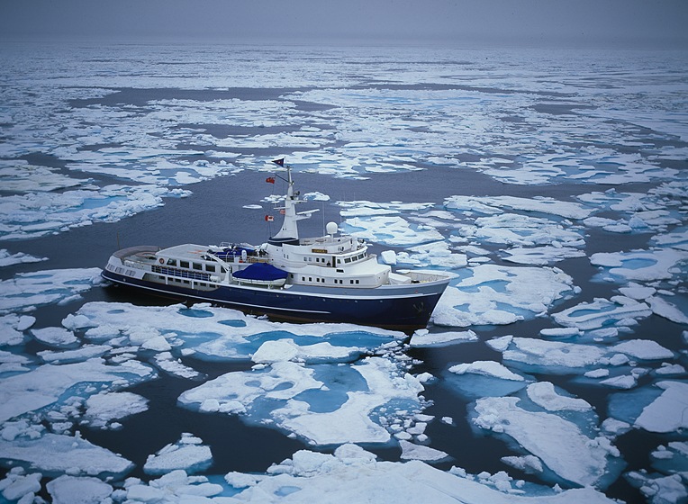
ARCTIC, #152: “Itasca’s” arrival at Pond Inlet is well into the evening, and Bill Simon suggests we await going ashore until morning, instead having a good-bye dinner aboard with our pilot, who has until now, eaten with the staff. After a great meal, and a good deal of drinking, we all retire and sleep well. We have crossed through the Northwest Passage, the first yacht to accomplish that in a single season. From here on out, we will see huge icebergs from Greenland in the Atlantic, but there will be no surface ice, or blocking flows. Ultimately, our last port is Greenland, from where we will all fly home. In the morning, Bill is “eager to engage” with Pond Inlet, so an earlier-than-usual breakfast is had by all, and then we go ashore. The helicopter pilot has one last task - to ferry the MANY multi-gallon canisters for gas, off of our boat, and to the local airport. As much as we flew, we actually carried nearly twice as much gas as we used. That Bill, always on the safe side! Visiting villages usually involves walking around, and often meeting people that John Bockstoce knows. Our group does just that for most of the morning, while the pilot proceeds with the offload. We plan to connect with him at the airport before lunch. We do meet people in our socializing meander, and several times there are comments from the Natives, that we have succeeded in our crossing, because of climate change. They also say they see less ice in their bay, and most nearby glaciers have melted back from tideline. Upon return to the airport, Bill is considering re-selling the unused gas for the helicopter to the town, as their fuel prices are sky-high, when a curious thing happens - a cargo-like mail plane lands, and the two pilots come into the terminal building, where we are gathered. Bill and John both engage them immediately about what they do, where they fly, and where they are going. They respond that they are on a regular mail and supplies “loop” to numerous villages, much farther north. As we guests return to “Itasca” for lunch, I can clearly see that Bill’s “wheels” are turning.
photograph(s) © copyright, ROBERT GLENN KETCHUM, 2019, @RbtGlennKetchum @LittleBearProd #LittleBearProd
Follow Robert Glenn Ketchum's Photographic Activism Online:
LINKEDIN: linkedin.com/in/RbtGlennKetchum
FACEBOOK: facebook.com/RobertGlennKetchum
FACEBOOK: facebook.com/NoPebbleMine.photos
TWITTER: twitter.com/RbtGlennKetchum
SOCIAL MEDIA by #LittleBearProd: @LittleBearProd
Wednesday, July 3, 2019

ARCTIC: At the Cutting Edge of Climate Change, #151:
ARCTIC, #151: Shortly after the helicopter pilot and I return to “Itasca,” we arrive at the entrance to the straight between Baffin and Bylot islands, which we enter as we head towards Pond Inlet. The copter pilot and I have flown a bit of this Baffin Island shoreline previously, but Bylot has not had much of our attention. It is a large island capped by a massive icefield, and has numerous glaciers descending on all sides. Most of the island is part of Sirmilik National Park. Bylot is very dramatic with steep walls dropping to the shoreline, and with no threatening weather, most of the guests finally emerge from their staterooms to join me on deck and watch the landscape pass by. In several places, we can see glacial valleys left after their glacier has retreated, but at the moment I do not give that much consideration. That will change when we arrive at Pond Inlet and start talking to the Inuit in the village. Finally our cruise arrives in a big bay called Eclipse Sound, and rounds a peninsula on Bylot which brings Pond Inlet into view. Most of this part of our voyage has been ice-free, and although there are some small grounded floes along the shore, the huge bay is completely open water. We are not the only ones here, however. There are several cargo ships in port, I presume bringing supplies to the village, and there is the largest iceberg I have ever seen floating in the middle of the bay. It is late evening now, and the weather I flew in earlier in the day has finally caught up with us, so they sky has filled with a thin layer of clouds that are glowing from the backlight of the setting sun. We establish an anchorage, but do not go ashore, as Bill wants to wait until morning, before engaging with the residents and offloading our helicopter.
photograph(s) © copyright, ROBERT GLENN KETCHUM, 2019, @RbtGlennKetchum @LittleBearProd #LittleBearProd
Follow Robert Glenn Ketchum's Photographic Activism Online:
LINKEDIN: linkedin.com/in/RbtGlennKetchum
FACEBOOK: facebook.com/RobertGlennKetchum
FACEBOOK: facebook.com/NoPebbleMine.photos
TWITTER: twitter.com/RbtGlennKetchum
SOCIAL MEDIA by #LittleBearProd: @LittleBearProd
Wednesday, June 26, 2019

ARCTIC: At the Cutting Edge of Climate Change, #150:
ARCTIC, #150: With a storm coming in, the ceiling of clouds above us slowly lowering, and Lancaster Sound virtually invisible under a dense layer of fog, I am apprehensive to say the least. My pilot, however, seems unconcerned, and I have little choice but to trust his experience. He pilots us to what should be about the middle of the sound, and then he turns toward the east, where we hope to find “Itasca.” It appears he is right about the pattern of the weather. As we fly east, the fog over the sound thins, and then, finally, disappears completely. The incoming weather lingers above us, but it seems that we will even fly out from beneath that quite soon, because I can see open sky in the distance, and the world around us is, once again, much more visible. Now to find “Itasca.” We fly east for some time, and it is noticeable that the ice cover on the water is also REALLY diminishing. There are still small floes here and there, but this is truly open water compared to what we have struggled to navigate through during the last two weeks. This open water is why our pilot is leaving us, as he will not be needed to scout for leads any longer. With so much blue below us, “Itasca” is easy to see when we finally come upon her. She has also traveled a good distance, motoring at an increased speed without fear of running into any floes. When we land, some of the guests are still in recovery mode, trying to survive the John Bockstoce birthday party of the night before, but Bill Simon is in fine spirit, and excited to hear about our adventure. As we explain our experience, he asks me if I “took some pictures.” Thankfully, I did, even though I WAS distracted by my concerns.
photograph(s) © copyright, ROBERT GLENN KETCHUM, 2019, @RbtGlennKetchum @LittleBearProd #LittleBearProd
Follow Robert Glenn Ketchum's Photographic Activism Online:
LINKEDIN: linkedin.com/in/RbtGlennKetchum
FACEBOOK: facebook.com/RobertGlennKetchum
FACEBOOK: facebook.com/NoPebbleMine.photos
TWITTER: twitter.com/RbtGlennKetchum
SOCIAL MEDIA by #LittleBearProd: @LittleBearProd
Wednesday, June 19, 2019

ARCTIC: At the Cutting Edge of Climate Change, #149:
ARCTIC, #149: In the last post, I wrote, “If this is to be my last helicopter flight…," not meaning anything to do with my death, but rather having to give up the copter and send it home. However, when the pilot and I end our exploratory of Devon Island through the fog and haze of a changing weather system, and turn homeward, things only get worse. Departing the shoreline of Devon, with hopes of returning to “Itasca,” this is what we encounter (above) instead. The storm sky from the west has arrived, and is coming down on us. Worse, Lancaster Sound has completely disappeared under a dense layer of fog. My pilot notices my substantial exhale of breath, followed by an “Oh my god!,” and immediately says, not to worry, that we are good. Really? I cannot see the surface of the sound, or much of ANYTHING, in fact, and what little we can see of Baffin Island is slowly disappearing. My pilot says we are safe, “as long as we can see those walls, so we don’t fly into them” - a little pilot joke, I guess, but it does not give me much comfort. I also note that we are getting low on fuel. He assures me we are fine, and then suggests this weather has come from the west, and “Itasca” is way east of us, likely not even affected, as yet, by what we are seeing (or not seeing, as the case may be). He also assures me that we can always land on an ice flow and wait this out, if we have to. This gives me NO comfort at all. Let’s hope he is right about heading east.
photograph(s) © copyright, ROBERT GLENN KETCHUM, 2019, @RbtGlennKetchum @LittleBearProd #LittleBearProd
Follow Robert Glenn Ketchum's Photographic Activism Online:
LINKEDIN: linkedin.com/in/RbtGlennKetchum
FACEBOOK: facebook.com/RobertGlennKetchum
FACEBOOK: facebook.com/NoPebbleMine.photos
TWITTER: twitter.com/RbtGlennKetchum
SOCIAL MEDIA by #LittleBearProd: @LittleBearProd
Wednesday, June 12, 2019

ARCTIC: At the Cutting Edge of Climate Change, #148:
ARCTIC, #148: On the last day our helicopter and pilot will be with us, before departing when “Itasca” arrives at Pond Inlet, he and I have gone flying once again. Taking a new tact because fog is forming around the summits of Baffin Island, we are flying at a MUCH higher elevation than our previous exploratory trips, and we are backtracking a bit, heading west and north over Lancaster Sound toward Devon Island. With much more ice on the water below, there is a distinct increase in ocean-level fog patches, but all of them are well below us. We have no concern for the fog-enshrouded island summits either, because we are above them also. What appears to be weather flowing in from the west is above us, but it is not creating turbulence, so we are enjoying our ride, and the spectacle of the Arctic unfolding all around us. By the time we reach the shores of Devon, the weather comes over us, and the day darkens, but remains quite visually dramatic - massive rafts of ice, shrouded by patches of fog float below us, and mesa summits play peek-a-boo. If this is to be my final helicopter flight, it is a GREAT day to be out-and-about, and I am glad NOT to be back at the boat with a terrible hangover.
photograph(s) © copyright, ROBERT GLENN KETCHUM, 2019, @RbtGlennKetchum @LittleBearProd #LittleBearProd
Follow Robert Glenn Ketchum's Photographic Activism Online:
LINKEDIN: linkedin.com/in/RbtGlennKetchum
FACEBOOK: facebook.com/RobertGlennKetchum
FACEBOOK: facebook.com/NoPebbleMine.photos
TWITTER: twitter.com/RbtGlennKetchum
SOCIAL MEDIA by #LittleBearProd: @LittleBearProd
Wednesday, June 5, 2019

ARCTIC: At the Cutting Edge of Climate Change, #147:
ARCTIC, #147: With fog forming around the mesa summits of Baffin Island, my pilot has suggested we do “something different,” to which I agree, and that game plan is to cross Lancaster Sound, and head toward Devon Island, while moving to a much higher flight elevation. Most of what we have done when flying previously, has been at quite low elevation, because we have been exploring river valleys and shorelines. This new perspective is an AWESOME change, and gives me a mind-blowing sense of this dramatic Arctic landscape.”Itasca” is somewhere in the far distance to the left, and she is about to make a right turn, heading into a straight that will lead to to Pond Inlet. My pilot and I are going the opposite direction, and are about to cross Lancaster Sound to have a look at Devon. We are above the fog-enshrouded summits of all the islands, but because we are headed into the more ice-choked part of the sound, there are an increasing number of ocean-level fog patches that appear, and a high-ceiling weather system seems to be flowing in from the west. At the moment, it is all way too beautiful to be of any concern, but it IS the Arctic, and one should never assume anything.
photograph(s) © copyright, ROBERT GLENN KETCHUM, 2019, @RbtGlennKetchum @LittleBearProd #LittleBearProd
Follow Robert Glenn Ketchum's Photographic Activism Online:
LINKEDIN: linkedin.com/in/RbtGlennKetchum
FACEBOOK: facebook.com/RobertGlennKetchum
FACEBOOK: facebook.com/NoPebbleMine.photos
TWITTER: twitter.com/RbtGlennKetchum
SOCIAL MEDIA by #LittleBearProd: @LittleBearProd
Wednesday, May 29, 2019

ARCTIC: At the Cutting Edge of Climate Change, #146:
ARCTIC, #146: While “Itasca” navigates ever closer to Pond Inlet, where our helicopter and pilot will leave us, most onboard “sleep in” following the wild birthday party for John Bockstoce the night before. I, on the other hand, know my colleagues are not likely to wake and want to fly, but I do. The pilot likes touring me around, as well, so we lift off before anybody except the staff arises. This day will prove to be one of our more “interesting” encounters with conditions in the Arctic. Initially, it is relatively sunny, but recall that it snowed just two days before ( posts #127-132), so now there is warming air circulating over cold landforms, and an even colder Lancaster Sound. For the moment we are flying familiar territory at our usual elevation, then we encounter fog forming around the summits of the mesas. My pilot suggests we could do “something different” today, as flying inland, into the increasing fog, might prove dangerous. Besides, we have traversed the interior valleys of Baffin Island quite a bit already, so I am up for change as well, and his thought is to cross the sound toward Devon Island, and REALLY gain some elevation, so that we have a more encompassing view of this amazing environment we are soon to leave, as we HAVE nearly completed our transit of the Northwest Passage.
photograph(s) © copyright, ROBERT GLENN KETCHUM, 2019, @RbtGlennKetchum @LittleBearProd #LittleBearProd
Follow Robert Glenn Ketchum's Photographic Activism Online:
LINKEDIN: linkedin.com/in/RbtGlennKetchum
FACEBOOK: facebook.com/RobertGlennKetchum
FACEBOOK: facebook.com/NoPebbleMine.photos
TWITTER: twitter.com/RbtGlennKetchum
SOCIAL MEDIA by #LittleBearProd: @LittleBearProd
Wednesday, May 22, 2019

ARCTIC: At the Cutting Edge of Climate Change, #145:
ARCTIC, #145: At one point in our early morning helicopter flight over Baffin Island, the vast coastal plains we have now encountered, give way to one of the biggest beaches I have ever seen. Not only is it stunningly wide, but it extends for miles down the coast, and actually wraps around into the channel “Itasca” will eventually enter, to navigate between Baffin and Bylot Island as we head for Pond Inlet. We do not land on this beach and walk around, but in retrospect, I wish we had. I am sure it is as amazing at ground level, as it is from the perspective above. I also have another consideration, and that is that I have been using a lot of helicopter time, and I do not want to irritate other hungover guests, that might want to fly, before we no longer have the copter available, so I suggest we should return to the boat, and we do. I really did not need to worry. When we get back, only Bill Simon is awake. The rest are still sleeping off the jubilation of the previous evening’s birthday party for John Bockstoce. Soon, “Itasca” will arrive at the Inuit village of Pond Inlet, where our helicopter pilot and his craft will leave us, as we will no longer need him to scout for open leads in the ice. Of note, Pond Inlet is a well developed and prosperous village that has landing strip large enough for cargo planes, and although, at the moment, that does not mean anything, it soon will, thanks to Bill Simon’s ever-adventurous mind.
photograph(s) © copyright, ROBERT GLENN KETCHUM, 2019, @RbtGlennKetchum @LittleBearProd #LittleBearProd
Follow Robert Glenn Ketchum's Photographic Activism Online:
LINKEDIN: linkedin.com/in/RbtGlennKetchum
FACEBOOK: facebook.com/RobertGlennKetchum
FACEBOOK: facebook.com/NoPebbleMine.photos
TWITTER: twitter.com/RbtGlennKetchum
SOCIAL MEDIA by #LittleBearProd: @LittleBearProd
Wednesday, May 15, 2019

ARCTIC: At the Cutting Edge of Climate Change, #144:
ARCTIC, #144: Captain Jouning and “Itasca” do not imbibe in the John Bockstoce birthday party (previous post), however, so next morning, while most of us are still sleeping, our craft pushes forward, heading east through Lancaster Sound, headed for the strait between Bylot and Baffin Islands. I am awake before most of the others, and the gods have spared me from a hangover, so after breakfast, I seek out the pilot to see if he would like to go flying again,..and he does. He says I bring good luck, and our flights are always interesting, so we launch before the rest of the guests even make an appearance. We have nearly reached the passage between the islands, so he and I decide to explore the channel ahead, and its shoreline. Initially, we encounter mesas punctuated by river valleys, much as we have seen on previous flights, and then the shoreline terrain begins to change. The mesas still define the interior of Baffin Island, but the beaches, and tundra plains in-between them become far more vast. Dotted with numerous streams and hundreds of ponds, these coastal plains span miles, and looking down from our remarkable vantage point, there are times where it seems, we are truly on another planet.
photograph(s) © copyright, ROBERT GLENN KETCHUM, 2019, @RbtGlennKetchum @LittleBearProd #LittleBearProd
Follow Robert Glenn Ketchum's Photographic Activism Online:
LINKEDIN: linkedin.com/in/RbtGlennKetchum
FACEBOOK: facebook.com/RobertGlennKetchum
FACEBOOK: facebook.com/NoPebbleMine.photos
TWITTER: twitter.com/RbtGlennKetchum
SOCIAL MEDIA by #LittleBearProd: @LittleBearProd
Wednesday, May 8, 2019

ARCTIC: At the Cutting Edge of Climate Change, #143:
ARCTIC, #143: Since the helicopter pilot and I have been out, flying/exploring most of the morning, I am grounded for the rest of the day. Now that the guests have learned of our discoveries, they all want have a look at these unusual valleys on Baffin Island, as well. This is all fine with me, since I am sure my morning shoot has been nothing short of remarkable, and besides, tonight is a special evening aboard “Itasca,” so I must prepare,..which means, “sleep now, drink later.” Tonight, our esteemed author, Arctic historian, and ever-humurous lunatic, John Bockstoce, is having his birthday, and there is every indication there will be a lot of liquor consumed. As evening draws close, and the last copter flight returns, the sauna is fired-up, a very elegant table has been set by the staff, and there is definitely anticipation amongst all of us, as we expect this “event” to “interesting” at the very least. Several cases of John’s preferred rum have been stacked behind the bar, and John has brought a collection of tapes from his cabin to provide music for the evening. Dinner is a fine food event, that deteriorates toward the end into boatful of very drunk people. Then we retire to the “party room,” where the music gets cranked-up, and after-dinner drinks are being poured. Entertainment is soon provided, as John decides to do some karaoke to his favorite country western songs. He also has a camera in hand, which he is constantly waving around and firing off, although he never looks through the viewfinder, or points it at anything in particular. I love this guy! A good time is had by all. We party into the night, wisely sauna once more before bed, and then we retire, all hoping to arise in the morning without hangovers.
photograph(s) © copyright, ROBERT GLENN KETCHUM, 2019, @RbtGlennKetchum @LittleBearProd #LittleBearProd
Follow Robert Glenn Ketchum's Photographic Activism Online:
LINKEDIN: linkedin.com/in/RbtGlennKetchum
FACEBOOK: facebook.com/RobertGlennKetchum
FACEBOOK: facebook.com/NoPebbleMine.photos
TWITTER: twitter.com/RbtGlennKetchum
SOCIAL MEDIA by #LittleBearProd: @LittleBearProd
Wednesday, May 1, 2019

ARCTIC: At the Cutting Edge of Climate Change, #142:
ARCTIC, #142: My helicopter pilot flies most of the time for a Canadian mining company out of Yellowknife. I ask if working with them, has he ever seen anything like this, thinking the amazing color tones in this basin, must be due to some unique mineralogy. He agrees with me about the probable influence of minerals, but says he has never seen anything like this before, especially the golden sand and silt. At the far end of this basin, the last fingers of dark soil dissipate, giving way to huge golden beach, with some really deep, crystal-clear pools. Then, as suddenly as it appeared, the colorful plain narrows once again, the watercourse becomes more channelized, and the golden sands give way to brown tundra. We are getting low on gas, and need to get back to “Itasca,” but to our good fortune the remarkable stream we have been following, is also headed for the shores of Lancaster Sound, and within minutes it comes into view. As we hoped, “Itasca” is quite close by, and so we head home to regale the guests with our discovery,..and to get some warm food!
photograph(s) © copyright, ROBERT GLENN KETCHUM, 2019, @RbtGlennKetchum @LittleBearProd #LittleBearProd
Follow Robert Glenn Ketchum's Photographic Activism Online:
LINKEDIN: linkedin.com/in/RbtGlennKetchum
FACEBOOK: facebook.com/RobertGlennKetchum
FACEBOOK: facebook.com/NoPebbleMine.photos
TWITTER: twitter.com/RbtGlennKetchum
SOCIAL MEDIA by #LittleBearProd: @LittleBearProd
Wednesday, April 24, 2019

ARCTIC: At the Cutting Edge of Climate Change, #141:
ARCTIC, #141: Dazzled by the vibrant colors of this basin we have discovered in the interior of Baffin Island, my helicopter pilot and I continue to follow this most unusual river. A few meanders further along, and the broad plain becomes even broader, and flattens out. This allows the water to spread out flowing over both the golden sand and the dark earth material that appears to be leaching out from beneath the rolling tundra. The width of the valley at this point allows us to circle in the helicopter, and view this spectacle from all angles. We also discover that further downstream, after passing through the “mud flats,” the water emerges even more vibrantly blue-green and crystal clear, to flow through channels, and some deep pools on a HUGE “beach” of golden sand and silt. We are speechless, this is SO unlike anywhere else we have explored. In retrospect, I am sorry we did not land,..and drink the water!
photograph(s) © copyright, ROBERT GLENN KETCHUM, 2019, @RbtGlennKetchum @LittleBearProd #LittleBearProd
Follow Robert Glenn Ketchum's Photographic Activism Online:
LINKEDIN: linkedin.com/in/RbtGlennKetchum
FACEBOOK: facebook.com/RobertGlennKetchum
FACEBOOK: facebook.com/NoPebbleMine.photos
TWITTER: twitter.com/RbtGlennKetchum
SOCIAL MEDIA by #LittleBearProd: @LittleBearProd
Wednesday, April 17, 2019

ARCTIC: At the Cutting Edge of Climate Change, #140:
ARCTIC, #140: The river my helicopter pilot and I have decided to follow for awhile, initially attracts our attention because of its unusual green color, which we think might be due to algae growth in thermal-warmed water. At the point we discover it (last post) we are above a valley flying into the interior of Baffin Island. It is our intention to navigate a route to the north, then back to the east shore of Lancaster Sound, where we expect to find “Itasca.” Rather obligingly, the colorful watercourse we have chosen to follow, also turns into a narrowing side-valley and heads north. Follow the meanders, it all gets a lot more interesting, as the water begins to change color, transitioning from a cloudy green shade to an ever-more translucent blue-green. Several small side streams feed into the one we follow, then suddenly, our narrow valley opens onto a new broad plain, that doesn’t look like anything else we have seen on the entire trip. The cerulean water seems to be flowing through golden sand, and some sort of dark mud layers, appear to be leaching out of the brown tundra valley floor. This basin is a color spectacle compared to the tonally similar valleys we have been exploring for the last few days. We have found something VERY interesting!
photograph(s) © copyright, ROBERT GLENN KETCHUM, 2019, @RbtGlennKetchum @LittleBearProd #LittleBearProd
Follow Robert Glenn Ketchum's Photographic Activism Online:
LINKEDIN: linkedin.com/in/RbtGlennKetchum
FACEBOOK: facebook.com/RobertGlennKetchum
FACEBOOK: facebook.com/NoPebbleMine.photos
TWITTER: twitter.com/RbtGlennKetchum
SOCIAL MEDIA by #LittleBearProd: @LittleBearProd
Wednesday, April 10, 2019

ARCTIC: At the Cutting Edge of Climate Change, #139:
ARCTIC, #139: My pilot and I are on a morning exploration of Baffin Island, which, so far, has been spectacular. We started with some flying up river valleys in the interior, then we returned to the coast of Lancaster Sound, still heading to the east. We have now reached our return point, and plan to meander back to the west by flying through interior valleys, once again. The one we have picked is broad, and relatively clear of low clouds. Winding through the mesas, valleys usually narrow as we reach their head, but the one we have chosen does not seem to rise much, and just continues to twist and turn, on-and-on. Then, unexpectedly, we emerge into this VERY big valley (above), being fed by numerous streams. In the distance you can see a shallow river with hundreds of fingers, but water is actual pouring in from all sides. Over our many days of flying together, the pilot and I have developed a similar response to things we see. The greater landscape and the weather playing across it, is dramatic, but relatively always the same - the desert-like terrain, ice-covered water, etc. When there is some variance in that, it is immediately visually notable. Such is the case at this moment, because in this expansive valley, flowing with a myriad of streams, this one is deeper, and a completely different color. My pilot thinks the color is algae, perhaps fed by water coming from a warm thermal source. Very interesting to look at in the context of the greater landscape, we decide we will follow this for awhile to see where it goes.
photograph(s) © copyright, ROBERT GLENN KETCHUM, 2019, @RbtGlennKetchum @LittleBearProd #LittleBearProd
Follow Robert Glenn Ketchum's Photographic Activism Online:
LINKEDIN: linkedin.com/in/RbtGlennKetchum
FACEBOOK: facebook.com/RobertGlennKetchum
FACEBOOK: facebook.com/NoPebbleMine.photos
TWITTER: twitter.com/RbtGlennKetchum
SOCIAL MEDIA by #LittleBearProd: @LittleBearProd
Wednesday, April 3, 2019

ARCTIC: At the Cutting Edge of Climate Change, #138:
ARCTIC, #138: My pilot and I are flying on a cosmic morning of weather and light. We began by navigating into the heart of Baffin Island following river valleys. We then flew east for a time, ultimately remerging on the shore of Lancaster Sound, which we have been flying above for the last few posts. It is our intention to pick another valley we find interesting, then follow it back into the interior, once again, eventually backtracking to the west, and hopefully, returning to “Itasca.” Our choice of river valley is arbitrary, as we simply respond to what we see and what looks interesting,..and this does. As we round the east edge of a mesa our flight parallels (last post), this valley appears, and both of us agree, it looks inviting. It is broad, with a significant flow of water, and we can see that further into the interior, the clouds have lifted off the summits, so our flight visibility should be even better.
photograph(s) © copyright, ROBERT GLENN KETCHUM, 2019, @RbtGlennKetchum @LittleBearProd #LittleBearProd
Follow Robert Glenn Ketchum's Photographic Activism Online:
LINKEDIN: linkedin.com/in/RbtGlennKetchum
FACEBOOK: facebook.com/RobertGlennKetchum
FACEBOOK: facebook.com/NoPebbleMine.photos
TWITTER: twitter.com/RbtGlennKetchum
SOCIAL MEDIA by #LittleBearProd: @LittleBearProd
Wednesday, March 27, 2019

ARCTIC: At the Cutting Edge of Climate Change, #137:
ARCTIC, #137: A few days from now, “Itasca” will arrive at the Native village of Pond Inlet and our helicopter pilot will depart, because we no longer have a need to scout the ice for open water. We will be through the Northwest Passage. In the meantime, the guests are all “joy-riding” in the helicopter to see the amazing landscapes surrounding Lancaster Sound. This particular morning started out cold, and VERY windy, so among the guests, everyone was happy to let me fly first, in hopes the weather would settle down later. As far as the pilot and I are concerned, it has been a little bouncy, with an occasional surprising side-wind, but the morning could not be more dramatic, and full of visual surprises. To arrive at this point, we have flown through backcountry river valleys of Baffin Island, navigating deeply into the interior to start, and then working our way east, and back to the coast. Now out on the coast, we are in a fierce windstream, flying along the shore, and scouting for a new valley to explore. Our plan is to choose one, dive back into the interior, and then work our way to the west, ultimately returning to “Itasca.” We do not know it just yet, but ahead of us, around the corner of this closest mesa, the valley we are looking for will appear.
photograph(s) © copyright, ROBERT GLENN KETCHUM, 2019, @RbtGlennKetchum @LittleBearProd #LittleBearProd
Follow Robert Glenn Ketchum's Photographic Activism Online:
LINKEDIN: linkedin.com/in/RbtGlennKetchum
FACEBOOK: facebook.com/RobertGlennKetchum
FACEBOOK: facebook.com/NoPebbleMine.photos
TWITTER: twitter.com/RbtGlennKetchum
SOCIAL MEDIA by #LittleBearProd: @LittleBearProd
Wednesday, March 20, 2019

ARCTIC: At the Cutting Edge of Climate Change, #136:
ARCTIC, #136: As we fly east, we pass two mesa-valley systems on Baffin Island, but the distant mesa on Bylot Island does not seem to get much closer. It is a fact that distance can be more difficult to judge in the Arctic because the air is so clear. At our present position, the cloud cover has broken a bit, and we are getting spotlights of sun swimming across the landscape. Numerous small streams flow beneath us, but just ahead, we will encounter a considerable river and valley, into which we will turn (right), beginning our attempt to work our way back to “Itasca” through the Baffin Island backcountry. In another day or two, “Itasca” will navigate past these bays, and turn into a passage between Baffin and Bylot Island, headed for the village of Pond Inlet. It is there that our helicopter pilot will disembark, and return to his regular territory of work around Yellowknife.
photograph(s) © copyright, ROBERT GLENN KETCHUM, 2019, @RbtGlennKetchum @LittleBearProd #LittleBearProd
Follow Robert Glenn Ketchum's Photographic Activism Online:
LINKEDIN: linkedin.com/in/RbtGlennKetchum
FACEBOOK: facebook.com/RobertGlennKetchum
FACEBOOK: facebook.com/NoPebbleMine.photos
TWITTER: twitter.com/RbtGlennKetchum
SOCIAL MEDIA by #LittleBearProd: @LittleBearProd
Wednesday, March 13, 2019

ARCTIC: At the Cutting Edge of Climate Change, #135:
ARCTIC, #135: Our first view of the Baffin Island shoreline of Lancaster Sound extending to the east, is VERY dramatic. Both the pilot and I make numerous exclamations. He is having as much fun as I am, because this is an amazing day to be out here,..and it is our job! If you look at the water you can see the direction of the wind, which is strong enough to drive icebergs into the shore, and then pile others, upon one another. We decide to stay at our low elevation and over the plain of the shore as we fly towards the farthest mesa in this image. That mesa is actually quite a distance away and part of Bylot Island, the last island before entering Baffin Bay and the North Atlantic. Our plan is to fly in that direction, until we find a valley of interest. We will then follow that valley into the Baffin Island backcountry once again, and attempt to work our way back to our boat.
photograph(s) © copyright, ROBERT GLENN KETCHUM, 2019, @RbtGlennKetchum @LittleBearProd #LittleBearProd
Follow Robert Glenn Ketchum's Photographic Activism Online:
LINKEDIN: linkedin.com/in/RbtGlennKetchum
FACEBOOK: facebook.com/RobertGlennKetchum
FACEBOOK: facebook.com/NoPebbleMine.photos
TWITTER: twitter.com/RbtGlennKetchum
SOCIAL MEDIA by #LittleBearProd: @LittleBearProd
Wednesday, March 6, 2019

ARCTIC: At the Cutting Edge of Climate Change, #134:
ARCTIC, #134: We have flown pretty far inland on Baffin Island, and now are headed back to the northern shoreline, but both the pilot and I are enjoying the unusual landscape we are traversing, so we fly low, and slow following meandering river valleys. Occasionally we encounter some interesting crosswinds as it has been very blustery since sunrise, and those winds travel through these wandering valleys in unexpected ways. The buffeting and bounce seem to increase as the river plain beneath us broadens, and my pilot says that it must really be blowing out in Lancaster Sound, because we are approaching the windy shore now, and that is why we are being more aggressively blown around. He barely finishes his sentence when we round the corner of this mesa, and the sound appears. There is A LOT of ice moving around being pushed by a strong, unabating wind. “Itasca” is off somewhere to the left, and we cannot see her at this point, but we don’t care because we still have plenty of fuel, and a beautiful, albeit “breezy,” day. So, we turn to the right in this image and fly down the shoreline, heading east, pushed along by a jetstream of cold air.
photograph(s) © copyright, ROBERT GLENN KETCHUM, 2019, @RbtGlennKetchum @LittleBearProd #LittleBearProd
Follow Robert Glenn Ketchum's Photographic Activism Online:
LINKEDIN: linkedin.com/in/RbtGlennKetchum
FACEBOOK: facebook.com/RobertGlennKetchum
FACEBOOK: facebook.com/NoPebbleMine.photos
TWITTER: twitter.com/RbtGlennKetchum
SOCIAL MEDIA by #LittleBearProd: @LittleBearProd
Wednesday, February 27, 2019

ARCTIC: At the Cutting Edge of Climate Change, #133:
ARCTIC, #133: In the last post, I speak of the surprise of sudden “reveals,” while flying low and slow in our helicopter. I also point out that we were headed to a very narrowing part of the valley we were following, as it turned to the left. We have now made that turn to the left, passed through the “narrows,” and.., surprise! A whole new interior world is revealed, and this particular one is flowing with water that is coming in from MANY directions. After these last 3 posts, I will again remind my readers that the Arctic is a true desert that receives less than 6” of precipitation per year. Amazingly, it supports a stunning array of life, but as these posts make very clear, there is not a lot of obvious vegetation down there. As this flight continues, the broad floodplain in this shot rises to the right, so we fly in that direction for awhile, but the pilot decides we should work to the north once again, so we pick a side canyon, make a turn into it, and begin wending our way back toward the Lancaster Sound shoreline.
photograph(s) © copyright, ROBERT GLENN KETCHUM, 2019, @RbtGlennKetchum @LittleBearProd #LittleBearProd
Follow Robert Glenn Ketchum's Photographic Activism Online:
LINKEDIN: linkedin.com/in/RbtGlennKetchum
FACEBOOK: facebook.com/RobertGlennKetchum
FACEBOOK: facebook.com/NoPebbleMine.photos
TWITTER: twitter.com/RbtGlennKetchum
SOCIAL MEDIA by #LittleBearProd: @LittleBearProd
Wednesday, February 20, 2019

ARCTIC: At the Cutting Edge of Climate Change, #132:
ARCTIC, #132: As our exploratory flight pushes more deeply into the valleys along the northern coast of Baffin Island, the valley we have chosen to follow, narrows. Because our helicopter is so small, we do not need much area in which to turn around, and as my pilot points out, if we really got stuck, we could put it on the ground almost anywhere, get out and turn it around by dragging its tail. Comfortable with that concept, I am good with our continuing push up this river, just to see its source, most likely a glacier feeding in from the icefield above these summits. Immediately ahead in this shot, you turn to the left, which from here, appears to be fairly tight passage. The beauty of flying, especially this low and slow, is that you come upon things quickly, and I find both of us are often surprised at what open up beneath our little plexiglass bubble. Many times it feels that instead of going from one place to another, it is more like going from one world to another.
photograph(s) © copyright, ROBERT GLENN KETCHUM, 2019, @RbtGlennKetchum @LittleBearProd #LittleBearProd
Follow Robert Glenn Ketchum's Photographic Activism Online:
LINKEDIN: linkedin.com/in/RbtGlennKetchum
FACEBOOK: facebook.com/RobertGlennKetchum
FACEBOOK: facebook.com/NoPebbleMine.photos
TWITTER: twitter.com/RbtGlennKetchum
SOCIAL MEDIA by #LittleBearProd: @LittleBearProd
Wednesday, February 13, 2019

ARCTIC: At the Cutting Edge of Climate Change, #131:
ARCTIC, #131: Our morning remained overcast by high clouds that still clung to the island summits, where there were also fresh deposits of snow from the night before. The wind blew in dramatic gusts, as you might have noticed the riffles on the water in the last two posts. It also made for an occasional breathtaking moment as it pushed the copter around, but my pilot has been flying in northern Canada and the Arctic most of his life, and he seems to have a good read on our daily conditions. When we left “Itasca,” we headed across open water toward Baffin Island. Since we have flown a number of beaches and shorelines, we decide to explore river valleys into the backcountry on this flight. Because of the low clouds, visibility of the summits is limited, but there is plenty of visibility to fly UNDER that ceiling, as we can see for miles. The pilot reasons that if we reach a point we can’t get through, we will just turn around and follow the same valley back out. Otherwise, he says, this will be like picking a path through a maze, and we need not worry about getting lost, because all rivers flow north will lead us back to Lancaster Sound.
photograph(s) © copyright, ROBERT GLENN KETCHUM, 2019, @RbtGlennKetchum @LittleBearProd #LittleBearProd
Follow Robert Glenn Ketchum's Photographic Activism Online:
LINKEDIN: linkedin.com/in/RbtGlennKetchum
FACEBOOK: facebook.com/RobertGlennKetchum
FACEBOOK: facebook.com/NoPebbleMine.photos
TWITTER: twitter.com/RbtGlennKetchum
SOCIAL MEDIA by #LittleBearProd: @LittleBearProd
Wednesday, February 6, 2019

ARCTIC: At the Cutting Edge of Climate Change, #130:
ARCTIC, #130: “Itasca” is slowly reaching a point in her traverse of Lancaster Sound, that we are now surrounded by islands that have glacial ice caps. Devon Island, to the north of us, is crowned by a massive icefield, that sends large glaciers down to tidewater, completely around the eastern shore. Bylot Island, which we are slowly approaching is equally active, generating glaciers that descend on all sides. And, above Pond Inlet is a Baffin Island icefield that hosts numerous tidewater glaciers as well. As a result, for the first time we begin to see huge bergs of glacial ice mixed in with the the ice cover of the frozen Arctic Ocean. These bergs are small islands, or in some cases, small mountains. This one (above) is the first we see, but as we progress toward Pond Inlet they will appear more frequently. When we cross the Atlantic for Greenland, their scale will become ridiculous, because we will be in “iceberg alley,” where all the bergs breaking off Greenland’s glacial faces deposit themselves.
photograph(s) © copyright, ROBERT GLENN KETCHUM, 2019, @RbtGlennKetchum @LittleBearProd #LittleBearProd
Follow Robert Glenn Ketchum's Photographic Activism Online:
LINKEDIN: linkedin.com/in/RbtGlennKetchum
FACEBOOK: facebook.com/RobertGlennKetchum
FACEBOOK: facebook.com/NoPebbleMine.photos
TWITTER: twitter.com/RbtGlennKetchum
SOCIAL MEDIA by #LittleBearProd: @LittleBearProd
Wednesday, January 30, 2019

ARCTIC: At the Cutting Edge of Climate Change, #129:
ARCTIC, #129: The cold breeze of the morning continues to pick up, and in the helicopter we bounce around a bit, but I am far too distracted by the spectacle of the day over Lancaster Sound to be concerned. I trust my pilot. If you are wondering about the scale of the sound, this image offers an excellent perspective. We are now several miles away from “Itasca,” and we are headed toward those mountains in the distance. Those closest to us are part of Baffin Island. Way, way down the sound, those last mountains beneath the clouds, are Bylot Island. What you cannot see from this perspective is a significant channel separates Baffin from Bylot, and there is a Native village there known as Pond Inlet. Our group is headed there, as it is where our helicopter pilot will leave us and head back to Yellowknife. All the more reason to fly with him as much as possible, NOW!
photograph(s) © copyright, ROBERT GLENN KETCHUM, 2019, @RbtGlennKetchum @LittleBearProd #LittleBearProd
Follow Robert Glenn Ketchum's Photographic Activism Online:
LINKEDIN: linkedin.com/in/RbtGlennKetchum
FACEBOOK: facebook.com/RobertGlennKetchum
FACEBOOK: facebook.com/NoPebbleMine.photos
TWITTER: twitter.com/RbtGlennKetchum
SOCIAL MEDIA by #LittleBearProd: @LittleBearProd
Wednesday, January 23, 2019

ARCTIC: At the Cutting Edge of Climate Change, #128:
ARCTIC, #128: Our group of merry adventurers notes that the first snow of the season has fallen on the Arctic overnight, and surely winter is coming. However, we have also had a moment of sauna-enlightenment, and we all realize how unique this trip has become, so rather than hurry to complete our journey, we all agree to move ahead at a more leisurely pace, and to utilize the helicopter to flight-see as much as possible. Given our new perspective, after breakfast, Captain Jouning gets underway once again, and as “Itasca” slowly threads through the ice of Lancaster Sound, the pilot warms up the helicopter. Interestingly, as the day awakes, the cold wind from the night before arises as well, and really starts to rip. Among the guests that have not flown much, there is a notable hesitance to go up in the blustery weather. I, however, having flown A LOT of hours with this pilot, am not put off by the “breeze,” and he says we are good to fly, so I go, because no one else wants to as yet.
photograph(s) © copyright, ROBERT GLENN KETCHUM, 2019, @RbtGlennKetchum @LittleBearProd #LittleBearProd
Follow Robert Glenn Ketchum's Photographic Activism Online:
LINKEDIN: linkedin.com/in/RbtGlennKetchum
FACEBOOK: facebook.com/RobertGlennKetchum
FACEBOOK: facebook.com/NoPebbleMine.photos
TWITTER: twitter.com/RbtGlennKetchum
SOCIAL MEDIA by #LittleBearProd: @LittleBearProd
Wednesday, January 16, 2019

ARCTIC: At the Cutting Edge of Climate Change, #127:
ARCTIC, #127: Our common conversation in the sauna after a remarkable day of flying over the various islands surrounding Lancaster Sound, is that we are already past the point that might have caused our attempted Northwest Passage traverse to fail, and now the navigation before us appears to be very doable, but not without ice and some peril. Nonetheless, we are all confident that we will get through, and our timing is so much earlier than we expected, the consensus is that we should not be in a great hurry to complete the trip, but rather, settle back, go a bit more slowly, and enjoy days exploring with the helicopter. That thought in mind, and a opulent dinner, we retire to awake to this. The advancing storm of the previous evening was not only cold enough to freeze “brash” ice while I was shooting, but during the night, winter arrived in the Arctic, and it has received the first snow. Our morning is blustery cold, and all the islands are snow-dusted. At breakfast, John Bockstoce points this out and suggests whatever we are going to do, we better do it soon, as time is running out - Arctic weather and the north Atlantic might turn against us anytime now..
photograph(s) © copyright, ROBERT GLENN KETCHUM, 2019, @RbtGlennKetchum @LittleBearProd #LittleBearProd
Follow Robert Glenn Ketchum's Photographic Activism Online:
LINKEDIN: linkedin.com/in/RbtGlennKetchum
FACEBOOK: facebook.com/RobertGlennKetchum
FACEBOOK: facebook.com/NoPebbleMine.photos
TWITTER: twitter.com/RbtGlennKetchum
SOCIAL MEDIA by #LittleBearProd: @LittleBearProd
Wednesday, January 9, 2019

ARCTIC: At the Cutting Edge of Climate Change, #126:
ARCTIC, #126: Not long after the last helicopter tour returns, the sauna is fired, the drinks are poured,..and the sky darkens considerably. As you can see, a front is sweeping in. It is growing substantially colder quickly, and a cold Arctic wind begins to pick up. I am on the lowest deck, shooting through the rails for this almost water-level POV, and while I am kneeling here making pictures, I can see the surface water crystalizing into ice. It IS cold! The incoming storm is dramatic to watch as we all do for awhile, and when we finally retire to the sauna, we all agree it has been a most amazing day. Sauna speculation leads to a “what now?” moment, upon which Bill thinks we should all reflect. The logistical reality of where we are, is that we have passed the crux point of the trip, the James Ross Straight, where polar ice might have blocked us, and now, although there is still plenty of ice through which to navigate, all the evidence suggests we will get through to the Atlantic and on to Greenland, much sooner than we expected.
photograph(s) © copyright, ROBERT GLENN KETCHUM, 2019, @RbtGlennKetchum @LittleBearProd #LittleBearProd
Follow Robert Glenn Ketchum's Photographic Activism Online:
LINKEDIN: linkedin.com/in/RbtGlennKetchum
FACEBOOK: facebook.com/RobertGlennKetchum
FACEBOOK: facebook.com/NoPebbleMine.photos
TWITTER: twitter.com/RbtGlennKetchum
SOCIAL MEDIA by #LittleBearProd: @LittleBearProd
Wednesday, January 2, 2019

ARCTIC: At the Cutting Edge of Climate Change, #125:
ARCTIC, #125: Of course, when our helicopter returns to “Itasca,” Bill Simon and the other guests are very excited to learn about what we have seen this morning, and now they all want to go flight-seeing as well. My day is over for the time being, but the poor pilot is going to have a long one. After several trips spread throughout the rest of the afternoon, everybody that wants to, gets an aerial tour. There are a lot of animal sightings (polar bear, musk ox), and a bit of beach visiting, such as I had done early in the morning. There is also some trophy taking. Many of us acquire a cool, lichen-covered rocks from here and there. Then there are larger discoveries. Flying above an interior dry valley with some dark tundra vegetation, Bill Simon spots this because its pale white tonalities stand out. When they land to inspect, they discover a pair of “locked” caribou antlers. This occurs when two males square-off in a fight, and get their antlers so entangled, they can not separate themselves. Inevitably wolves find them easy prey. Bill could not resist claiming his discovery, and since he will fly home from Greenland in his own plane, he has the room to collect pretty much whatever he wants.
photograph(s) © copyright, ROBERT GLENN KETCHUM, 2019, @RbtGlennKetchum @LittleBearProd #LittleBearProd
Follow Robert Glenn Ketchum's Photographic Activism Online:
LINKEDIN: linkedin.com/in/RbtGlennKetchum
FACEBOOK: facebook.com/RobertGlennKetchum
FACEBOOK: facebook.com/NoPebbleMine.photos
TWITTER: twitter.com/RbtGlennKetchum
SOCIAL MEDIA by #LittleBearProd: @LittleBearProd
Wednesday, December 26, 2018

ARCTIC: At the Cutting Edge of Climate Change, #124:
ARCTIC, #124: Fortunately for all of us, no one will be sleeping on a gravel beach, huddled around a rock ring fire (last post). I have been out a good part of the day, we are now low on fuel, and other guests want to go flying. While we have been exploring, “Itasca” has continued to motor through Lancaster Sound. There is some ice, but nothing compared to what we have seen previously. There are also many places it is quite shallow, so as we journey on, we anchor for the nights and shut off the engines and generators, so it is quiet. During the day, “Itasca” proceeds once again, and weather permitting, we all go out in runs in the helicopter to explore the islands surrounding us. When I tell Bill Simon what we have seen on this morning’s jaunt, he is eager to take a flight himself, so the copter is refueled, the pilot grabs a lunch, and soon a new group will be back in the air. Me? I just shot 15 rolls of film, and I am burned out. I am having a beer and getting in the sauna - LOL!
photograph(s) © copyright, ROBERT GLENN KETCHUM, 2018, @RbtGlennKetchum @LittleBearProd #LittleBearProd
Follow Robert Glenn Ketchum's Photographic Activism Online:
LINKEDIN: linkedin.com/in/RbtGlennKetchum
FACEBOOK: facebook.com/RobertGlennKetchum
FACEBOOK: facebook.com/NoPebbleMine.photos
TWITTER: twitter.com/RbtGlennKetchum
SOCIAL MEDIA by #LittleBearProd: @LittleBearProd
Wednesday, December 19, 2018

ARCTIC: At the Cutting Edge of Climate Change, #123:
ARCTIC, #123: This is another Thule people historical site. These are not marked places, but in our helicopter, they are pretty obvious from overhead. This camp has midden remains, rock rings likely used for fires, and a good deal of whale bones scattered here and there. Perhaps this was a site used by whale hunters. Because we have the luxury of being able to land, I also get to observe these locations at ground level. What becomes clear is that virtually every site affords a view of, and close location to, possible prey. Some like this are positioned with views of prime water in which to hunt. Other locations are near bird cliffs, or along the known pathway of migrating caribou. It is amazing to be standing here, delivered by a helicopter, and to contemplate another group standing here, who see it as “home.” That is a tough group! I know for a fact, I do not want to sleep out here tonight.
photograph(s) © copyright, ROBERT GLENN KETCHUM, 2018, @RbtGlennKetchum @LittleBearProd #LittleBearProd
Follow Robert Glenn Ketchum's Photographic Activism Online:
LINKEDIN: linkedin.com/in/RbtGlennKetchum
FACEBOOK: facebook.com/RobertGlennKetchum
FACEBOOK: facebook.com/NoPebbleMine.photos
TWITTER: twitter.com/RbtGlennKetchum
SOCIAL MEDIA by #LittleBearProd: @LittleBearProd
Wednesday, December 12, 2018

ARCTIC: At the Cutting Edge of Climate Change, #122:
ARCTIC, #122: Having John Bockstoce aboard our trip is a great asset, not only because he is very funny and fun to be around, but also because he has great knowledge of the Arctic, expressed through his many books. Most of us may not see much here, but John says archeologists have identified this, and many other sites like this, as remnant middens and walls of Thule people. The Arctic has had human inhabitants for a very long time. Dorset culture were what are known to be the earliest, then they were followed by Thule. Today, it is the world of the Inuit. As I have mentioned previously, the Arctic is a desert, generally receiving less than 6-inches of rainfall a year. It is also a very cold desert. As such there is little deterioration of anything and these ancient campsites can still be found and researched.
photograph(s) © copyright, ROBERT GLENN KETCHUM, 2018, @RbtGlennKetchum @LittleBearProd #LittleBearProd
Follow Robert Glenn Ketchum's Photographic Activism Online:
LINKEDIN: linkedin.com/in/RbtGlennKetchum
FACEBOOK: facebook.com/RobertGlennKetchum
FACEBOOK: facebook.com/NoPebbleMine.photos
TWITTER: twitter.com/RbtGlennKetchum
SOCIAL MEDIA by #LittleBearProd: @LittleBearProd
Wednesday, December 5, 2018

ARCTIC: At the Cutting Edge of Climate Change, #121:
ARCTIC, #121: At one point, the cliffs we follow begin to slope roundly downward as we approach a bay-like inlet. Eventually the lowering contour of land extends into a peninsula, upon which the shoreline below us still has old “attached" ice left from the summer break-up. The spare configurations of this Arctic landscape are amazing to witness, and I realize, once again, what a gift it is for my work to have access to a helicopter on a daily basis, and to be able to take flights like this one. What a morning! What a dry, strange habitat. It is surprising that it supports life at all, and yet, life flourishes here. Interestingly, the public views Antarctica as a continent with animals (penguins), but they migrate there, and in fact, Antarctica has no native species. The Arctic is VERY different, and as spare as it may appear, it has been home to man and animals for thousands of years - the Inuit, the Thule people, Dorset culture, probably the Vikings, and then of course, polar bear, the muskox, the Arctic fox, wolverines, caribou, and wolves. Those are just the big guys. There is a myriad of rodents - lemmings, shrews, voles, and the surrounding ocean waters are teeming with regionally unique species like walrus, beluga whale, and narwhal.
photograph(s) © copyright, ROBERT GLENN KETCHUM, 2018, @RbtGlennKetchum @LittleBearProd #LittleBearProd
Follow Robert Glenn Ketchum's Photographic Activism Online:
LINKEDIN: linkedin.com/in/RbtGlennKetchum
FACEBOOK: facebook.com/RobertGlennKetchum
FACEBOOK: facebook.com/NoPebbleMine.photos
TWITTER: twitter.com/RbtGlennKetchum
SOCIAL MEDIA by #LittleBearProd: @LittleBearProd
Wednesday, November 28, 2018

ARCTIC: At the Cutting Edge of Climate Change, #120:
ARCTIC, #120: Having made his remark about the danger of our helicopter spooking the bird rookeries in the shoreline cliffs, my pilot stays reasonably close to the wall and follows it into a right turn. As we swing around the turn he tells me to look down because there is a research “station” working with the birds just below us. Starting in the upper left, you can see two red ATV’s parked end-to-end, amidst the tundra and rubble. Moving down, and to the right, two blue tents are set up. Continuing on that line, further to the right, at the edge of the cliff, two researchers (in blue parkas) are standing, watching thousands of birds circulate. ALL the dots and specks you see against the walls are flying, or roosting, birds. I can see where frightening them and having them fly into our rotors is a bad idea.
photograph(s) © copyright, ROBERT GLENN KETCHUM, 2018, @RbtGlennKetchum @LittleBearProd #LittleBearProd
Follow Robert Glenn Ketchum's Photographic Activism Online:
LINKEDIN: linkedin.com/in/RbtGlennKetchum
FACEBOOK: facebook.com/RobertGlennKetchum
FACEBOOK: facebook.com/NoPebbleMine.photos
TWITTER: twitter.com/RbtGlennKetchum
SOCIAL MEDIA by #LittleBearProd: @LittleBearProd
Wednesday, November 21, 2018

ARCTIC: At the Cutting Edge of Climate Change, #119:
ARCTIC, #119: On our helicopter fly around Lancaster Sound, we are exploring the shoreline and coastal plains of Baffin Island. We touch down on one of the large “beaches” for awhile and watch a fog/light show, but as the fog has become dense around us, the pilot wants to be back in the air to assure we can still find “Itasca.” Once up, we can see the fog is growing more dense in patches, but we still have most of our visibility, so we feel no immediate pressure to return to our boat, and continue to explore. There are some very dramatic shoreline cliffs protruding from the fog, as you can see here, so we fly a line across their faces, just above the mesa tops. It is a dry, desert-like terrain of rock and lichen, but when I ask to get closer, my pilot says that it is not safe because we will spook birds. Apparently, these sheer cliffs make excellent rookeries, that keep nesting birds safe from predatory Arctic foxes.
photograph(s) © copyright, ROBERT GLENN KETCHUM, 2018, @RbtGlennKetchum @LittleBearProd #LittleBearProd
Follow Robert Glenn Ketchum's Photographic Activism Online:
LINKEDIN: linkedin.com/in/RbtGlennKetchum
FACEBOOK: facebook.com/RobertGlennKetchum
FACEBOOK: facebook.com/NoPebbleMine.photos
TWITTER: twitter.com/RbtGlennKetchum
SOCIAL MEDIA by #LittleBearProd: @LittleBearProd
Wednesday, November 14, 2018

ARCTIC: At the Cutting Edge of Climate Change, #118:
ARCTIC, #118: The helicopter pilot and I have been flying above Lancaster Sound and Baffin Island for a good part of the morning, when waves of fog begin to form. At one point we see a broad beach, and I suggest we land to watch the light show and have a look at things from ground level (last post). The beach is strange and spare, but the fog/light show is over the top. There is a cold wind blowing causing rolling tubes of fog sweep over us, noticeably dropping the temperature even further, and coating our plastic gear with moisture. Unexpectedly, and rather abruptly, the wind dies down, the turbulence stops, and the fog diffuses. Immediately diffuse vapor particles alight the sky with a golden glow, and then the sky and horizon merge. We are floating! For several minutes, the pilot and I are speechless, and I just take pictures, but the condition is clearly evolving, and the fog is becoming more dense, surrounding us. Finally, the pilot snaps out of our reverie and says we should probably fly. If the fog is this thick everywhere, he is concerned we might not find “Itasca" until it clears.
photograph(s) © copyright, ROBERT GLENN KETCHUM, 2018, @RbtGlennKetchum @LittleBearProd #LittleBearProd
Follow Robert Glenn Ketchum's Photographic Activism Online:
LINKEDIN: linkedin.com/in/RbtGlennKetchum
FACEBOOK: facebook.com/RobertGlennKetchum
FACEBOOK: facebook.com/NoPebbleMine.photos
TWITTER: twitter.com/RbtGlennKetchum
SOCIAL MEDIA by #LittleBearProd: @LittleBearProd
Wednesday, November 7, 2018

ARCTIC: At the Cutting Edge of Climate Change, #117:
ARCTIC, #117: Besides flying above the amazing Arctic landscape, another fun aspect of having a helicopter at my disposal and a willing pilot, is that we can set it down to explore on the ground a bit,..and so we do. This is an expansive gravel beach with several streams flowing across it, and it was more than broad enough for us to land. I want to see the beach, but there is also a remarkable, and quickly changing, fog and light show going on, out over the water. A cold breeze has blown lots of brash ice against the shore, and it is roiling the fog, causing it to spiral, and snake around in irregular lines. It is an amazing thing to watch, and the pilot and I just stand speechless as it all goes down. Hey, we don’t have anywhere else to be!
photograph(s) © copyright, ROBERT GLENN KETCHUM, 2018, @RbtGlennKetchum @LittleBearProd #LittleBearProd
Follow Robert Glenn Ketchum's Photographic Activism Online:
FACEBOOK: http://www.facebook.com/NoPebbleMine.photos
FACEBOOK: http://www.facebook.com/RobertGlennKetchum
FACEBOOK: http://www.facebook.com/RobertGlennKetchum
SOCIAL MEDIA by #LittleBearProd @LittleBearProd
Wednesday, October 31, 2018

ARCTIC: At the Cutting Edge of Climate Change, #116:
ARCTIC, #116: Our morning flight leaves Lancaster Sound and heads down an arm of water that extends for some miles into Baffin Island. As I have noted previously in this blog, the Arctic is a desert, and often gets less than 6” of rain in a year. Our flight is now over terrain that definitely does look like a desert landscape, were there not big icebergs in the water. This is really a rock-rubble plain that does not even host much lichen - VERY spare! Thus, it was surprising to me to see this structure, what appears to be an abandoned home, and there is nothing else around. The pilot tells further down this arm, there is a sizable Native village, Arctic Bay, and a major mine and mining town, Nanisivik. He thinks it is likely someone living there built this for fishing/hunting access.
photograph(s) © copyright, ROBERT GLENN KETCHUM, 2018, @RbtGlennKetchum @LittleBearProd #LittleBearProd
Follow Robert Glenn Ketchum's Photographic Activism Online:
FACEBOOK: http://www.facebook.com/NoPebbleMine.photos
FACEBOOK: http://www.facebook.com/RobertGlennKetchum
FACEBOOK: http://www.facebook.com/RobertGlennKetchum
SOCIAL MEDIA by #LittleBearProd @LittleBearProd
Wednesday, October 24, 2018

ARCTIC: At the Cutting Edge of Climate Change, #115:
ARCTIC, #115: The dark, bold forms of the Arctic islands around us, change as we get closer to them. The outlines of hills and valleys begin to reveal the subtleties of their terrain. There are numerous streams and rivers that descend from the tundra mountains and flow to the sound. Like all rivers, they host wetlands, and form beaches and spits. This far north, however, there is not much vegetation to support, except the tundra. In fact, I am surprised to see so much water as the Arctic is ACTUALLY A DESERT, generally receiving less than 2-inches of rain per year. Along this expansive gravel shoreline, we encounter several delta/wetlands like this, a number of swans down on the water in some, and offshore, an occasional Beluga whale. Best of all, this day has just begun. The more we fly, the more I see, the more amazing these places become, as I grow to appreciate their spare beauty, and the remarkable Arctic light.
photograph(s) © copyright, ROBERT GLENN KETCHUM, 2018, @RbtGlennKetchum @LittleBearProd #LittleBearProd
Follow Robert Glenn Ketchum's Photographic Activism Online:
FACEBOOK: http://www.facebook.com/NoPebbleMine.photos
FACEBOOK: http://www.facebook.com/RobertGlennKetchum
FACEBOOK: http://www.facebook.com/RobertGlennKetchum
SOCIAL MEDIA by #LittleBearProd @LittleBearProd
Wednesday, October 17, 2018

ARCTIC: At the Cutting Edge of Climate Change, #114:
ARCTIC, #114: Up, up, and away! I am greeting the morning in Lancaster Sound, with a helicopter flyover of this new terrain of which we are now in the midst. Somerset Island is to the right, a small portion of Baffin Island pokes in from the left. We are going to fly down the channel between them to start our adventure. Scale is difficult to grasp, but those are substantial mountains that form the two islands, and if you look to the right, you will see a silver “sliver” along the shoreline of Somerset. We are going to fly directly over that in the next post, and you may be surprised to see what, and how big, that sliver is.
photograph(s) © copyright, ROBERT GLENN KETCHUM, 2018, @RbtGlennKetchum @LittleBearProd #LittleBearProd
Follow Robert Glenn Ketchum's Photographic Activism Online:
FACEBOOK: http://www.facebook.com/NoPebbleMine.photos
FACEBOOK: http://www.facebook.com/RobertGlennKetchum
FACEBOOK: http://www.facebook.com/RobertGlennKetchum
SOCIAL MEDIA by #LittleBearProd @LittleBearProd
Wednesday, October 10, 2018

ARCTIC: At the Cutting Edge of Climate Change, #113:
ARCTIC, #113: Early morning in Lancaster Sound, is a spectacle of light, weather, and scale. The sound is huge, and surrounded by many large islands. There are ice floes, but plenty of open water, and what fog there is, runs in bands across the surface of the sound, skewing the light and creating strange illusions (last post). The cloud ceiling is high, and the fog does not really obscure anything, so I want to go up in the helicopter again, and investigate these new locations. Devon Island is to our north, and Somerset and Baffin Island lie to our south. They all have mountains and river valleys we can see from “Itasca,” and Devon has numerous descending glaciers. Traversing the sound will take several days by boat, and If the weather permits, I hope to fly at every opportunity. This image is the first one I take as we lift off. Looks like it is going to be an interesting flight.
photograph(s) © copyright, ROBERT GLENN KETCHUM, 2018, @RbtGlennKetchum @LittleBearProd #LittleBearProd
Follow Robert Glenn Ketchum's Photographic Activism Online:
FACEBOOK: http://www.facebook.com/NoPebbleMine.photos
FACEBOOK: http://www.facebook.com/RobertGlennKetchum
FACEBOOK: http://www.facebook.com/RobertGlennKetchum
SOCIAL MEDIA by #LittleBearProd @LittleBearProd
Wednesday, October 3, 2018

ARCTIC: At the Cutting Edge of Climate Change, #112:
ARCTIC, #112: As we continue motoring north, Itasca navigates between Prince of Wales Island and Somerset Island, eventually coming to the point where the strait opens into Lancaster Sound. The sound is vast, with a lot of open water, and an entirely new view. The sky is swimming with weather and color, and we are surrounded by numerous islands. We navigate, east into Lancaster Sound, passing between Somerset and the sizable, Devon Island. In the days ahead, other helicopter flights will afford me many more views of Devon, as it is large and quite dramatic, but at this moment it is performing a “magic” trick, and appears to be floating above the horizon. This is not a mirage like those seen earlier in our voyage. This is an act of weather. A dense, water-level, Arctic fog, covers the open water ahead of us, and it causes the edge of the ice floe to appear as the horizon, above which the island “floats.” This continues to be an evermore amazing day!
photograph(s) © copyright, ROBERT GLENN KETCHUM, 2018, @RbtGlennKetchum @LittleBearProd #LittleBearProd
Follow Robert Glenn Ketchum's Photographic Activism Online:
FACEBOOK: http://www.facebook.com/NoPebbleMine.photos
FACEBOOK: http://www.facebook.com/RobertGlennKetchum
FACEBOOK: http://www.facebook.com/RobertGlennKetchum
SOCIAL MEDIA by #LittleBearProd @LittleBearProd
Wednesday, September 26, 2018

ARCTIC: At the Cutting Edge of Climate Change, #111:
ARCTIC, #111: In the helicopter, scouting the passage for Itasca, we parallel the rocky vertical shoreline of Prince of Wales Island. The pilot and I have become quite good a noticing small details while we fly, like polar bears sleeping on ice floes, however, this morning I see something new. I notice a dark, shadow of morphing shapes in the water immediately adjacent the rugged cliffs of POW. Even the pilot is not sure what we are looking at, and then he realizes we are seeing millions of black cod, feeding in the shallows. We cannot see the individual fish, but we watch the shifting “cloud” in fascination, as it it vacillates in the water beneath us. Then something else catches my eye. It is out in deeper water, and it is white, but it is not a polar bear. A little further on, there are more, in groups. Actually “they” are in pods, and they are Beluga whales... hundreds of them, and they have come in from all over the Arctic to feed on the block cod. We fly a considerable distance along the vertical shore, and all the while beneath us, millions and millions of cod, are being pursued by hundreds of whales. There is a pod of 8 in this shot, in the middle, at the bottom of the frame. Besides taking still pictures on this trip, I have also been asked to shoot film, and this spectacle is so astounding, I put down my Pentax 645, and spend the rest of the morning working with my movie camera. We fly to the juncture of where our strait merges into Lancaster Sound, and then we turn back, flying across the top of Prince of Wales. It is a tundra terrain of rolling hills and valleys, and the wonders of the morning only continue. Flying low to the terrain, we crest a ridge, and surprise a large herd of musk ox that gallop off in terror. We follow while I shoot some footage, then break off so as not to disturb the animals too much. Leaving the land, our copter crosses over the cliffs and back into the strait, but I notice another white “thing,” halfway up the cliff face. It is a HUGE polar that is, quite literally, free-climbing the wall effortlessly. Immediately the pilot says, “he is going after the musk ox!” This flight is quite a remarkable way to start the day.
photograph(s) © copyright, ROBERT GLENN KETCHUM, 2018, @RbtGlennKetchum @LittleBearProd #LittleBearProd
Follow Robert Glenn Ketchum's Photographic Activism Online:
FACEBOOK: http://www.facebook.com/NoPebbleMine.photos
FACEBOOK: http://www.facebook.com/RobertGlennKetchum
FACEBOOK: http://www.facebook.com/RobertGlennKetchum
SOCIAL MEDIA by #LittleBearProd @LittleBearProd
Wednesday, September 19, 2018

ARCTIC: At the Cutting Edge of Climate Change, #110:
ARCTIC, #110: Bill Simon’s somewhat risky gamble to follow the wake of the Sir John Franklin in an attempt to extract us and Itasca from our ice-locked position, pays off. The SJF was departing after their contact with us, to head northwest, up through the M'Clintoch Channel, from where all the pack ice had come. Tailgating them for a short distance, allows us to get out of the entrapping ice, and once we do, we then turn sharply right, and run close to the western shoreline of Prince of Wales Island, which has more open water. Hugging the shore, Itasca works her way around the southern tip of Prince of Wales, and then turns north and east, into the strait that will ultimately connect us with Lancaster Sound, further north. While not ice free, the strait is VERY navigable, and so we have circumvented what all agreed would be the most dangerous crux of our entire journey. Now we all have hope we ARE actually going to get through the Northwest Passage in a single season. Finally in this kinder environment, and out of the ice entrapment, Bill is excited to move forward, and eager to make up for time lost while were were locked in the floes, so Itasca hoist anchor at daybreak and begins the journey north between Prince of Wales and the extended arm of the mainland peninsula (above). The sunrise is beautiful, and there is weather, but the cloud ceiling is high, so of course, Bill wants the helicopter to go scout ahead, and given the conditions, I can’t wait to be airborne once again.
photograph(s) © copyright, ROBERT GLENN KETCHUM, 2018, @RbtGlennKetchum @LittleBearProd #LittleBearProd
Follow Robert Glenn Ketchum's Photographic Activism Online:
FACEBOOK: http://www.facebook.com/NoPebbleMine.photos
FACEBOOK: http://www.facebook.com/RobertGlennKetchum
FACEBOOK: http://www.facebook.com/RobertGlennKetchum
SOCIAL MEDIA by #LittleBearProd @LittleBearProd
Wednesday, September 12, 2018

ARCTIC: At the Cutting Edge of Climate Change, #109:
ARCTIC, #109: With “Itasca” trying to follow in the open-water wake of the Sir John Franklin, there is no stopping to allow the helicopter to land, so my amazing pilot puts us down while the boat is underway. As soon as I step onto the deck, the magnitude of what we are doing becomes more obvious. "Itasca” is being furiously pummeled by big ice pieces thrown off by the SJF. Every contact causes us to shake and lurch, and the sound of crashing drowns out conversation. We cannot continue like this for very long or we will surely suffer damage. The SJF is a powerful ship and can move quickly under a full head of steam, so we trail behind for about 1/2 hour, then back down and turn to the northwest. We have been able to trail the SJF far enough to the north and east, up the M'Clintock Channel, that we are now abreast of the tip of Prince of Wales Island, where we hope to find enough open water close to shore and BEHIND the ice in which we have been trapped, so that we can slip into the Franklin Strait which is far more ice-free, AND going the direction we hope to navigate. Bill’s decision to do this proves dangerous, but correct - “Itasca” is not damaged, and we do find passable openings into the strait. Once there, we anchor for the night as most of us are worn out by the events of the day, ESPECIALLY Captain Jouning.
photograph(s) © copyright, ROBERT GLENN KETCHUM, 2018, @RbtGlennKetchum @LittleBearProd #LittleBearProd
Follow Robert Glenn Ketchum's Photographic Activism Online:
FACEBOOK: http://www.facebook.com/NoPebbleMine.photos
FACEBOOK: http://www.facebook.com/RobertGlennKetchum
FACEBOOK: http://www.facebook.com/RobertGlennKetchum
SOCIAL MEDIA by #LittleBearProd @LittleBearProd
Wednesday, September 5, 2018

ARCTIC: At the Cutting Edge of Climate Change, #108:
ARCTIC, #108: The tricky issue about following the open-water wake of the Sir John Franklin is that it is a much bigger boat (last post) and an icebreaker. Even though it is breaking ice, some of those “chunks” are huge, and when they come racing back in to refill the open-water gap, they carry considerable weight and force. Similarly, being too close to the SJF poses the risk of being hit head-on by some huge ice being blown out from beneath the hull buy their massive propellers, so our Captain Jouning has to be cautious to stay close enough to advantage the momentary open wake, but not so close that we get slammed. As you can see by looking closely here, everyone has come out on deck to witness this part of our journey. There is a lone figure at the bow, staring down at the water. That is the boatbuilder that told Bill he is concerned we are not structurally strong enough to “break” ice, and make no mistake about it, “Itasca” is getting SLAMMED, so he is very concerned.
photograph(s) © copyright, ROBERT GLENN KETCHUM, 2018, @RbtGlennKetchum @LittleBearProd #LittleBearProd
Follow Robert Glenn Ketchum's Photographic Activism Online:
FACEBOOK: http://www.facebook.com/NoPebbleMine.photos
FACEBOOK: http://www.facebook.com/RobertGlennKetchum
FACEBOOK: http://www.facebook.com/RobertGlennKetchum
SOCIAL MEDIA by #LittleBearProd @LittleBearProd
Wednesday, August 29, 2018

ARCTIC: At the Cutting Edge of Climate Change, #107:
ARCTIC, #107: While I am on an early morning scouting flight in our helicopter, the captain aboard the Sir John Franklin has heard through political channels that “Itasca” may proceed “as they choose,” as long as Bill signs-off on any liability on the part of the Canadian government, which he does. The SJF then communicates they are departing, AND they are headed north and east, up through the McClintock Channel. Bill Simon immediately seizes upon this information with a plan to move “Itasca” toward our destination, getting into the relatively ice-free Franklin Strait, so we can continue north and west. Our flight scouting has revealed that much of the dense ice has been pushed past us to the south by the series of storms we have endured. There is some open water behind this ice, and along the northern coast of Prince of Wales Island, so Bill decides to follow in the SJF wake, as it moves north, getting us to more open water, than we will turn west and attempt to enter the Franklin Strait. As you can see in this shot, the SJF is a MUCH larger boat than we are, AND it is an icebreaker. Once that boat pushes through ice, the ice flows rather rapidly back into the open water passage created, so when SJF turned to the north, “Itasca” had to follow immediately in order to advantage any open water, so long before our copter returns to the deck, Bill and guests are underway, all hoping his plan might work.
photograph(s) © copyright, ROBERT GLENN KETCHUM, 2018, @RbtGlennKetchum @LittleBearProd #LittleBearProd
Follow Robert Glenn Ketchum's Photographic Activism Online:
FACEBOOK: http://www.facebook.com/NoPebbleMine.photos
FACEBOOK: http://www.facebook.com/RobertGlennKetchum
FACEBOOK: http://www.facebook.com/RobertGlennKetchum
SOCIAL MEDIA by #LittleBearProd @LittleBearProd
Wednesday, August 22, 2018

ARCTIC: At the Cutting Edge of Climate Change, #106:
ARCTIC, #106: “Itasca’s” helicopter pilot and I are up for an early morning scouting expedition to see if the weather has opened up any possible leads in the ice. It does not look good in the direction we are hoping to travel, but on our return flight, the sky begins to clear, some sunlight filters through the remaining clouds, and we can see open water to the north and west. It is a good distance away, and the pilot wants to inspect more closely, so we are now flying low and fast over the pack. As we get closer to the “open” water, the big floes begin shrinking in size, and much more of the ocean surface is now visible. The extremes of light that I watch swimming through my lens are just amazing. Between the glaring sun, the white reflective ice, and the black ocean water, my meter is very confused. This is one of the moments out of many shots where it all came together.
photograph(s) © copyright, ROBERT GLENN KETCHUM, 2018, @RbtGlennKetchum @LittleBearProd #LittleBearProd
Follow Robert Glenn Ketchum's Photographic Activism Online:
FACEBOOK: http://www.facebook.com/NoPebbleMine.photos
FACEBOOK: http://www.facebook.com/RobertGlennKetchum
FACEBOOK: http://www.facebook.com/RobertGlennKetchum
SOCIAL MEDIA by #LittleBearProd @LittleBearProd
Wednesday, August 15, 2018

ARCTIC: At the Cutting Edge of Climate Change, #105:
ARCTIC, #105: Flying to the edge of the merging, re-freezing icefloes, we can see open water IN the Sir John Ross straight, the issue is how to get to it. Indeed, “Itasca” is NOT an ice-breaker. The weather that brought all of this ice, came from the north and west, blowing the ice to the south and east. As our helicopter flight heads back to the boat, south and east is to the left in the image above, north and west is to the right. In front of us, the sky appears to be clearing! I can see blue for the first time in days. Most amazingly, I can see blue WATER, on the horizon at the far right side of this frame. The storm has pushed all of this ice PAST us and is now driving it south, and a more open water is following behind. This could be VERY important to our progress, so we head in that direction to check it out. En route, we see the SJF has sent up their copter to investigate as well.
photograph(s) © copyright, ROBERT GLENN KETCHUM, 2018, @RbtGlennKetchum @LittleBearProd #LittleBearProd
Follow Robert Glenn Ketchum's Photographic Activism Online:
FACEBOOK: http://www.facebook.com/NoPebbleMine.photos
FACEBOOK: http://www.facebook.com/RobertGlennKetchum
FACEBOOK: http://www.facebook.com/RobertGlennKetchum
SOCIAL MEDIA by #LittleBearProd @LittleBearProd
Wednesday, August 8, 2018

ARCTIC: At the Cutting Edge of Climate Change, #104:
ARCTIC, #104: Our dinner aboard “Itasca” provides for a very interesting evening, as just before dusk we have been approached and contacted by the Canadian Coast Guard ice-breaker, “Sir John Franklin.” Their captain made clear to us that he does not want us to try to go forward, and would prefer we return to Gjoa Haven. Bill Simon has made it equally clear that he is NOT going to do that, and has asked the SJF’s captain to contact the Canadian Prime Minister on behalf of his request to continue. That having ended our communication with them for the night, we retire to dinner, but a short way into the meal, it takes unexpected turn. Bill speaks to us all, and says that he understands there IS a risk, so he wants each of us to say whether we are comfortable with going forward, or would rather go back. It happens that I am sitting next to him this evening, and he wants the question to go around the table, so he starts with me. I say that I am the least known amongst us all, but in the time I have spent with Bill, I recognize his determination, and I signed on to the adventure, so if he chooses to go forward, I am onboard and am going with him. After me, most in turn say if Bill wants to go, they will go,..UNTIL we get to the boat’s architect who is also aboard as a guest. He says he did not build an ice-breaker, and he thinks we should go back. He NEVER built another boat for Simon. In the morning, the blustery weather is gone and the ceiling has lifted. Bill wants to “assure” the SJF that we are serious about going forward, so with the open skies, he wants the helicopter up to scout for any changes. The days of steady, strong winds not only pushed massive iceflows into the straight through we hope to navigate, but it them crushed them into each other. Flying over this now, the pilot and I can see that big floes are crush-merged, and now they re-freezing, fusing together as a solid pack once again. This is truly not a good sign.
photograph(s) © copyright, ROBERT GLENN KETCHUM, 2018, @RbtGlennKetchum @LittleBearProd #LittleBearProd
Follow Robert Glenn Ketchum's Photographic Activism Online:
FACEBOOK: http://www.facebook.com/NoPebbleMine.photos
FACEBOOK: http://www.facebook.com/RobertGlennKetchum
FACEBOOK: http://www.facebook.com/RobertGlennKetchum
SOCIAL MEDIA by #LittleBearProd @LittleBearProd
Wednesday, August 1, 2018

ARCTIC: At the Cutting Edge of Climate Change, #103:
ARCTIC, #103: When we return to “Itasca" and report to Bill Simon that there IS open water above the James Ross Strait, BUT it looks unlikely that we can get there, he is disappointed but still determined to get through. As we all sit on the bridge discussing our options with Captain Jouning, the radio comes to life and we are being hailed by a Canadian Coast Guard ice-breaker, the Sir John Frankling. Jouning responds and as the conversation unfolds, we are told they have seen us “adrift” and with little progress, so they are worried we are trapped and they are going to “stop by.” It is late evening before they steam in, out of the fog and lowering sky, and at the moment of their arrival, we are actually in a spot of considerable open water,..not looking “trapped.” They once again establish radio contact and ask who we are and where we are going. Captain Jouning explains our goal, but the Captain of the John Franklin, says there is “no chance” our boat can get through the ice ahead, and they want us to go back to Gjoa Haven. Bill will have none of it, and so he takes the radio, informing the Franklin’s captain of who he is. He also informs him that he is going forward, NOT back to Gjoa Haven, and that he will sign-off on any waivers of responsibility the Canadians need, to let us to fend for ourselves. He suggests the captain of the John Franklin should contact his “friend” the Prime Minister, if he had any doubts about our intent to continue on. There is a moment of radio silence, and then the Franklin responds, "enjoy your evening, we will get back to you in the morning."
photograph(s) © copyright, ROBERT GLENN KETCHUM, 2018, @RbtGlennKetchum @LittleBearProd #LittleBearProd
Follow Robert Glenn Ketchum's Photographic Activism Online:
FACEBOOK: http://www.facebook.com/NoPebbleMine.photos
FACEBOOK: http://www.facebook.com/RobertGlennKetchum
FACEBOOK: http://www.facebook.com/RobertGlennKetchum
SOCIAL MEDIA by #LittleBearProd @LittleBearProd
Wednesday, July 25, 2018

ARCTIC: At the Cutting Edge of Climate Change, #102:
ARCTIC, #102: As we want to pass through the James Ross Strait, getting into a channel between Prince of Wales Island and Somerset Island which is nearly ice-free, the helicopter pilot and I fly north and west, searching for ANY openings that might be of advantage to our forward progress, but there is little, and in fact, it gets worse and worse. At one point we can barely see any open water, it is ALL, wall-to-wall ice floes. The pattern of easterly moving weather we have been experiencing, has pushed very large amounts of multi-year pack ice down through the Mclintoch Channel and into the Nunavut mainland shore, where it is now backing-up upon itself, and re-freezing. We do fly to the edge of this dense ice, however, and we see that the strait IS relatively open, and can be navigated. The problem is, how to get to it, because we are a LONG way from our boat at this point, and there is little open water between us.
photograph(s) © copyright, ROBERT GLENN KETCHUM, 2018, @RbtGlennKetchum @LittleBearProd #LittleBearProd
Follow Robert Glenn Ketchum's Photographic Activism Online:
FACEBOOK: http://www.facebook.com/NoPebbleMine.photos
FACEBOOK: http://www.facebook.com/RobertGlennKetchum
FACEBOOK: http://www.facebook.com/RobertGlennKetchum
SOCIAL MEDIA by #LittleBearProd @LittleBearProd
Wednesday, July 11, 2018

ARCTIC: At the Cutting Edge of Climate Change, #100:
ARCTIC, #100: Sitting in one place for several days because “Itasca” is ice-bound makes everyone (especially Bill Simon) a little stir-crazy. With the long daylight hours making time seem to go by even more slowly, there is a lot of napping and taking saunas among the guests. There is also a fair amount of alcohol consumption. John Bockstoce is SO particular about his beverage of choice, he had several cases shipped aboard, not leaving it to Bill to supply him. Now, in our lethargy of ice, he is consuming his precious rum in the morning coffee. Then, about midday, wearing only Bermuda shorts and a bathrobe, he grabs a long metal deck pole, announces he is going for a walk, steps over the lowest deck rail onto the ice, and he is off. That, in turn, sets off a frenzy. I follow him onto the ice to take pictures. Then the female staff appears in bikinis, and two of the men have a snowboard and a long rope. We are on a HUGE flow, so the guys take turns pulling each other on the snowboard, so they can say they rode at the top of the world (almost). John is wandering. I am looking for polar bears!
photograph(s) © copyright, ROBERT GLENN KETCHUM, 2018, @RbtGlennKetchum @LittleBearProd #LittleBearProd
Follow Robert Glenn Ketchum's Photographic Activism Online:
FACEBOOK: http://www.facebook.com/NoPebbleMine.photos
FACEBOOK: http://www.facebook.com/RobertGlennKetchum
FACEBOOK: http://www.facebook.com/RobertGlennKetchum
SOCIAL MEDIA by #LittleBearProd @LittleBearProd
Wednesday, July 4, 2018

ARCTIC: At the Cutting Edge of Climate Change, #99:
ARCTIC, #99: If you look carefully you can see Bill Simon on the bridge deck, just below the “Itasca” moniker. He is getting antsy that we are ice-bound. He was definitely NOT excited to hear our flight report, and so now he is pondering our choices. In the meantime, as we wait for a change of weather that might help us, I have two incidents worth recounting. The first finds me on the lowest deck, gazing out across the floes, when the chef comes out with garbage scraps and dumps them in the water. Amazingly, although we have not seen any animals or birds in days, within minutes, we have a seal and numerous gulls, all attracted to the remains. While he and I stand there watching the feeding frenzy, it suddenly occurs to me that you can just step over the rail and climb down onto the ice, or vice-versa. Therefore, if tossed garbage brings birds and a seal, when will the polar bear arrive? Probably better to rethink this tossing-the-garbage-out idea, at least until we are moving. Having a bear get aboard would not be a good thing. The second incident involves going for a walk,..on the floes!
photograph(s) © copyright, ROBERT GLENN KETCHUM, 2018, @RbtGlennKetchum @LittleBearProd #LittleBearProd
Follow Robert Glenn Ketchum's Photographic Activism Online:
FACEBOOK: http://www.facebook.com/NoPebbleMine.photos
FACEBOOK: http://www.facebook.com/RobertGlennKetchum
FACEBOOK: http://www.facebook.com/RobertGlennKetchum
SOCIAL MEDIA by #LittleBearProd @LittleBearProd
Wednesday, June 27, 2018

ARCTIC: At the Cutting Edge of Climate Change, #98:
ARCTIC, #98: In the helicopter and out-and-about on a scout, the world from this POV looks troubling. “Itasca” is ice-bound, there are bergs floating nearby that are the size of several football fields, and as we fly further out, this is what we find. This is not a good thing to find! Post #84 shows an ice-ridge we passed days ago and that was intimidating enough, but this is a mountain range, and it runs unbroken for miles. It is just a huge, curvaceous iceberg with an awesome ridge running right down the middle of it. The good news, if there is any, is that in the present weather conditions, this is moving away from us. The questions remains, however, what might be coming at us? None of this looks good for our progress....
photograph(s) © copyright, ROBERT GLENN KETCHUM, 2018, @RbtGlennKetchum @LittleBearProd #LittleBearProd
Follow Robert Glenn Ketchum's Photographic Activism Online:
FACEBOOK: http://www.facebook.com/NoPebbleMine.photos
FACEBOOK: http://www.facebook.com/RobertGlennKetchum
FACEBOOK: http://www.facebook.com/RobertGlennKetchum
SOCIAL MEDIA by #LittleBearProd @LittleBearProd
Wednesday, June 20, 2018

ARCTIC: At the Cutting Edge of Climate Change, #97:
ARCTIC, #97: Once airborne again, the view does not get any friendlier. This does not even look like the ocean I saw on my flight the day before. Everything has changed! There is much more old ice, and look at the size of these consolidated floes. OMG! This one is several football fields! There are still small leeds here and there, but none of them go far or appear to offer us a way forward. On this flight we will circle out to the right several miles, and then we will cross the view in this image, paralleling the horizon. If you look carefully, you will see a thin, dark line in the upper left of this picture, that is also parallel to the horizon. That line out there may not appear to be much, but next post we will be directly above it. It is NOT a leed, as you will see - this is a PROBLEM - and not the only one we have!
photograph(s) © copyright, ROBERT GLENN KETCHUM, 2018, @RbtGlennKetchum @LittleBearProd #LittleBearProd
Follow Robert Glenn Ketchum's Photographic Activism Online:
FACEBOOK: http://www.facebook.com/NoPebbleMine.photos
FACEBOOK: http://www.facebook.com/RobertGlennKetchum
FACEBOOK: http://www.facebook.com/RobertGlennKetchum
SOCIAL MEDIA by #LittleBearProd @LittleBearProd
Wednesday, June 13, 2018

ARCTIC: At the Cutting Edge of Climate Change, #96:
ARCTIC, #96: Although the sky remains ominous, the weather has actually calmed down, and for the moment we are not being pushed around by the pack ice. Because we have been blown south by the storm, we have lost ground gained in previous days, and Bill Simon grows ever more eager to get through this maze and get on with the trip. Since it is not windy at the moment and visibility is good, Bill wants the copter to go up and scout for any changes that might have occurred during the night of which we might take advantage. I am good to go as well, so we are off! Flying away from “Itasca,” I have my first view of what is our entrapped state. It is startling enough that I have the copter set down on a floe so I can make this image. It does appear that we are COMPLETELY ice-bound, although that is fortunately not the case. Nonetheless we are in a “predicament."
photograph(s) © copyright, ROBERT GLENN KETCHUM, 2018, @RbtGlennKetchum @LittleBearProd #LittleBearProd
Follow Robert Glenn Ketchum's Photographic Activism Online:
FACEBOOK: http://www.facebook.com/NoPebbleMine.photos
FACEBOOK: http://www.facebook.com/RobertGlennKetchum
FACEBOOK: http://www.facebook.com/RobertGlennKetchum
SOCIAL MEDIA by #LittleBearProd @LittleBearProd
Wednesday, June 6, 2018

ARCTIC: At the Cutting Edge of Climate Change, #95:
ARCTIC, #95: A storm besets us during the night, and although the rain and wind have stopped by dawn, the “damage” is done. “Itasca” has been pushed by the wind-driven ice pack many miles south, thus negating any advances we have made in the past few days. What is worse, is that the ice that has arrived with the storm, and which is now closing in around us on all sides, is REALLY OLD, multi-year ice that extends quite deeply beneath the surface. It is beautiful to look at, but a great threat to our progress as there is no way to push this around. Captain Jouning is quite concerned about all our situation, but Bill Simon insists we try to hold ground, and hope for an opening, rather than go back to Gjoa Haven, the closest village.
photograph(s) © copyright, ROBERT GLENN KETCHUM, 2018, @RbtGlennKetchum @LittleBearProd #LittleBearProd
Follow Robert Glenn Ketchum's Photographic Activism Online:
FACEBOOK: http://www.facebook.com/NoPebbleMine.photos
FACEBOOK: http://www.facebook.com/RobertGlennKetchum
FACEBOOK: http://www.facebook.com/RobertGlennKetchum
SOCIAL MEDIA by #LittleBearProd @LittleBearProd
Wednesday, May 30, 2018

ARCTIC: At the Cutting Edge of Climate Change, #94:
ARCTIC, #94: After 45-minutes of searching for open leads with no productive results, the helicopter pilot turns back toward Itasca’s position to head home, and as the 'copter gains a bit of altitude in our swing, we rise into a layer of cloud vapor. This is a very strange world to which we have come. We have had several days now where the weather has worked against us, blowing Arctic multi-year pack ice and icebergs directly into our path. As a result, our large, expensive vessel filled with distinguished guests is literally trapped in a continuous struggle to not be crushed or trapped by the ice, nor to be pushed aground by the continuously advancing pack. With the above view lingering in my mind while heading home, I am pretty sure things are going to get worse before they get better, assuming they ever do. That does not appear to be anytime soon either, because after I am back aboard, I learn another storm is expected in the night.
photograph(s) © copyright, ROBERT GLENN KETCHUM, 2018, @RbtGlennKetchum @LittleBearProd #LittleBearProd
Follow Robert Glenn Ketchum's Photographic Activism Online:
FACEBOOK: http://www.facebook.com/NoPebbleMine.photos
FACEBOOK: http://www.facebook.com/RobertGlennKetchum
FACEBOOK: http://www.facebook.com/RobertGlennKetchum
SOCIAL MEDIA by #LittleBearProd @LittleBearProd
Wednesday, May 23, 2018

ARCTIC: At the Cutting Edge of Climate Change, #93:
ARCTIC, #93: As if the vast scope of the ice-covered ocean is not enough, from this aerial perspective I can now begin to see the VERY different ice that has been blown into us by the prevailing winds. These are huge, multi-year icebergs that in many cases are MUCH larger than “Itasca.” We could never “break” through one, and we are too small to push them around. As we drift away from our boat, my helicopter pilot stays down low over the water, maintaining as much visibility as possible, because clouds are streaming through just above us. Our mission on this flight is to scout any hopeful leads towards which “Itasca” might navigate, but all that we find are huge ice islands, with very little open water around them. Flying further toward the James Ross Strait, a crux point of our journey forward, the islands and floes only get bigger and the conditions grow ever less inviting.
photograph(s) © copyright, ROBERT GLENN KETCHUM, 2018, @RbtGlennKetchum @LittleBearProd #LittleBearProd
Follow Robert Glenn Ketchum's Photographic Activism Online:
FACEBOOK: http://www.facebook.com/NoPebbleMine.photos
FACEBOOK: http://www.facebook.com/RobertGlennKetchum
FACEBOOK: http://www.facebook.com/RobertGlennKetchum
SOCIAL MEDIA by #LittleBearProd @LittleBearProd
Wednesday, May 16, 2018

ARCTIC: At the Cutting Edge of Climate Change, #92:
ARCTIC, #92: “Itasca” is now trapped in the flow of pack ice being driven at us by the weather. In the beginning, bergs were small enough to push around and there were sufficient open leads to keep moving forward. Now, it is the pack that is pushing us around, and unfortunately, pushing us toward shallower water where we might become grounded. To prevent that from happening, Captain Jouning has been motoring away from shore when given any chance, and now that the winds have died, the helicopter with me aboard, is going for a scouting expedition to see if there is a direction we could travel that might offer us some more open water and hope. My first view of the boat is sobering as I more fully realize our predicament (last post). As we move farther away from “Itasca,” I begin to realize what has happened to us in the larger context of Larsen Sound.
photograph(s) © copyright, ROBERT GLENN KETCHUM, 2018, @RbtGlennKetchum @LittleBearProd #LittleBearProd
Follow Robert Glenn Ketchum's Photographic Activism Online:
WEBSITE: http://www.robertglennketchum.com/
PINTEREST: http://www.pinterest.com/littlebearprod/
SOCIAL MEDIA by #LittleBearProd: http://www.LittleBearProd.com
Wednesday, May 9, 2018

ARCTIC: At the Cutting Edge of Climate Change, #91:
ARCTIC, #91: I think everyone is a little rattled by our present predicament, and the thought of flying in this bad weather does not seem appealing to anyone else,..except me, and I am good to go, so we are off. It does not seem dangerous to me, as there is little wind and visibility is very decent. What is revealed, however, that is more intimidating than the weather, is the position of the ship. “Itasca” is surrounded by the pack. Open water of any scale is a scarcity. We seem safely away from the shoreline for the time being, but we really have no path forward unless the winds and weather shift everything once again. Next week’s post will reveal how vast the scale of our obstacles are, as the helicopter ventures further from our boat.
photograph(s) © copyright, ROBERT GLENN KETCHUM, 2018, @RbtGlennKetchum @LittleBearProd #LittleBearProd
Follow Robert Glenn Ketchum's Photographic Activism Online:
WEBSITE: http://www.robertglennketchum.com/
PINTEREST: http://www.pinterest.com/littlebearprod/
SOCIAL MEDIA by #LittleBearProd: http://www.LittleBearProd.com
Wednesday, May 2, 2018

ARCTIC: At the Cutting Edge of Climate Change, #90:
ARCTIC, #90: Another problem with the increasing presence of multi-year ice surrounding “Itasca,” is that the ice is not only thicker than what we have seen, extending well down into the water beneath the bergs, but there are BIG plates of it everywhere,..whole islands of ice many times larger than “Itasca.” They are amazing to observe because their expansive surfaces are intricate mazes of ice ridges and blue pools, but in reality, they are a nightmare of navigation, and represent a real threat to us and our hopeful passage through the John Ross Strait. The rest of the day remains overcast and very windy, so the helicopter does not go up, and we all just kill time, waiting to see what is going to happen. Although the sky remains sullen and grey, about 3p.m. the wind dies down, and Bill Simon, who has grown antsy to keep moving forward, wants the copter to go up and scout, hoping it can find an open lead.
photograph(s) © copyright, ROBERT GLENN KETCHUM, 2018, @RbtGlennKetchum @LittleBearProd #LittleBearProd
Follow Robert Glenn Ketchum's Photographic Activism Online:
WEBSITE: http://www.robertglennketchum.com/
PINTEREST: http://www.pinterest.com/littlebearprod/
SOCIAL MEDIA by #LittleBearProd: http://www.LittleBearProd.com
Wednesday, April 25, 2018

ARCTIC: At the Cutting Edge of Climate Change, #89:
ARCTIC, #89: John Bockstoce correctly assessed the results of the weather approaching us late last evening, and during the night the wind grew in strength, pushing the pack ice into us, and pushing us, shoreward, into ever-shallower water. Several times Captain Jouning starts up the engines and motors INTO the pack away from the shore to assure we do not drift aground. In the morning, there is fleeting sunlight filtered through a strange haze created by the blowing ice crystals, so I go back to the same position on deck where I took my last picture the night before (last post), to view what is now a very different looking ocean. There is little open water left that is visible, and the majority of the ice-cover is becoming multi-year ice being blown from the north. Multi-year places us at greater risk because it is denser and extends more deeply beneath the surface. These larger icebergs have great weight and are much more difficult for “Itasca” to push around. In fact, they are pushing us around!
photograph(s) © copyright, ROBERT GLENN KETCHUM, 2018, @RbtGlennKetchum @LittleBearProd #LittleBearProd
Follow Robert Glenn Ketchum's Photographic Activism Online:
WEBSITE: http://www.robertglennketchum.com/
PINTEREST: http://www.pinterest.com/littlebearprod/
SOCIAL MEDIA by #LittleBearProd: http://www.LittleBearProd.com
Wednesday, April 18, 2018

ARCTIC: At the Cutting Edge of Climate Change, #88:
ARCTIC, #88: When John and I spot the approaching boat with the 4 armed, men dressed in fur parkas, we move off the bridge to the side deck to observe them more closely. Bill Simon goes on the intercom to tell staff, and then joins us. The boat is much closer now, and running parallel to us. There are a number of dead seals hanging off the stern, bleeding out into the water. It is a Native hunting party. They are looking at us with as much curiosity as we are looking at them. John and I wave. They wave back. Then one yells, “Who are you, and where are you going?” We explain we are a research vessel from the US, and we are trying to be the first private vessel to cross through the Northwest Passage in a single season. There is a brief silence, and then the question comes back, “Why?” Perfect! Why, indeed! Especially on such a good day for a hunt. I do notice that while the conversation is being exchanged, two staff members, now also fully armed, have positioned themselves just out-of-sight, on either side of Bill Simon. Once everyone grows comfortable, however, Bill sends them away, and invites the Natives aboard. “Itasca” and all of its opulence and technology amazes them. They especially like the “little” helicopter. We have excessive stores of food on board, so when they depart, Bill offers them some frozen meats, and a huge rasher of bacon. A good day for a hunt, indeed! Before they leave, they tell us that the pack ahead is very bad and storms are coming, so perhaps we should return to Gjoa Haven to wait out the weather. They motor off, and we motor on. Bill is not going back! Near-shore we make decent headway, but when we anchor for the night, the northwest wind resumes, pushing ice into Larsen Sound and bringing predicted serious weather with it.
photograph(s) © copyright, ROBERT GLENN KETCHUM, 2018, @RbtGlennKetchum @LittleBearProd #LittleBearProd
Follow Robert Glenn Ketchum's Photographic Activism Online:
WEBSITE: http://www.robertglennketchum.com/
PINTEREST: http://www.pinterest.com/littlebearprod/
SOCIAL MEDIA by #LittleBearProd: http://www.LittleBearProd.com
Wednesday, April 11, 2018

ARCTIC: At the Cutting Edge of Climate Change, #87:
ARCTIC, #87: The northwest wind blows all night long, and eventually it pushes ice against the hull, so subtle bonking begins in the early morning hours. By the time we awake for breakfast, and assemble, our POV is VERY different from the night before. As we expected, the pack has been pushed towards us and we are now surrounded. If there are open leads out there, no one can see them from this angle. Thankfully, the wind has ceased, and in fact, reversed a bit, so by the time breakfast is over, Captain Jouning has taken a scouting helicopter flight, and he believes that because “Itasca” has a relatively shallow draft, we will be able to move forward, close to the eastern shoreline, as the shift in the breeze is pushing the ice offshore. Progress is slow because we do not want to run aground in shallow water, but there seems to be little danger as we all sit on the bridge and watch the depth gauge radar. Then something curious happens. John Bockstoce and I notice that there is a small boat approaching us, traveling in the same open lead of water. It is a VERY small boat, and there are 4 men wearing fur parkas and armed with rifles, standing in up in it, staring towards us.
photograph(s) © copyright, ROBERT GLENN KETCHUM, 2018, @RbtGlennKetchum @LittleBearProd #LittleBearProd
Follow Robert Glenn Ketchum's Photographic Activism Online:
WEBSITE: http://www.robertglennketchum.com/
PINTEREST: http://www.pinterest.com/littlebearprod/
SOCIAL MEDIA by #LittleBearProd: http://www.LittleBearProd.com
Wednesday, April 4, 2018

ARCTIC: At the Cutting Edge of Climate Change, #86:
ARCTIC, #86: Most of this day is spent hiding from the icy wind, and looking for open leads. As dense as we have seen the ice in places, we also encounter, large areas of open water, but as we travel north and the day wears on, those are fewer and farther between. When we finally drop anchor for the night, there is an ominous shift in the wind. It begins to blow directly from the northwest, exactly the conditions that will push dense, multi-year ice from the polar pack, right down the M’Clintock Channel, choking the passage of Larsen Sound and the James Ross Strait. As threatening as that is (and we all know it), the incoming weather is strangely beautiful, so I decide to ponder the future of our trip by donning all my warm clothes, and going outside to sit on the lower deck to watch the extended twilight.
photograph(s) © copyright, ROBERT GLENN KETCHUM, 2018, @RbtGlennKetchum @LittleBearProd #LittleBearProd
Follow Robert Glenn Ketchum's Photographic Activism Online:
WEBSITE: http://www.robertglennketchum.com/
PINTEREST: http://www.pinterest.com/littlebearprod/
SOCIAL MEDIA by #LittleBearProd: http://www.LittleBearProd.com
Wednesday, March 28, 2018

ARCTIC: At the Cutting Edge of Climate Change, #85:
ARCTIC, #85: Bonking and grinding, “Itasca" creeps along. The going is slow, but at least we are going. The weather has not turned on us (yet), and there are definitely patches in the ice pack that are more open than elsewhere, so we try to stay in them as much as we can and maintain our direction. Eventually a brutal, cold wind begins to pick up, and before I duck inside for warmth, down on the lowest deck, shooting through the railing, I realize that there is “brash” floating in the green-water pond on this iceberg, and it is being congealed into the berg as the surface water is refreezing. I suppose that is to be expected, as we are headed north pretty late in the season, and for sure we knew it would be cold with winter coming, but along with all the other ice “presence,” the turn in the freezing breeze, and the increasing surfaces of endless white are intimidating.
photograph(s) © copyright, ROBERT GLENN KETCHUM, 2018, @RbtGlennKetchum @LittleBearProd #LittleBearProd
Follow Robert Glenn Ketchum's Photographic Activism Online:
WEBSITE: http://www.robertglennketchum.com/
PINTEREST: http://www.pinterest.com/littlebearprod/
SOCIAL MEDIA by #LittleBearProd: http://www.LittleBearProd.com
Wednesday, March 21, 2018

ARCTIC: At the Cutting Edge of Climate Change, #84:
ARCTIC, #84: The farther north we progress, the worse things seem to get. Raging, windy weather has keep the helicopter grounded, hence we have not been able to scout for leads, and we are just using radar to navigate. The going is slow and getting slower, because the wind is causing the pack to crush together. As striking as this image is, this is NOT a good thing to see in the way of your voyage. This is an ice ridge, created by plates of ice slamming into each other and then being crushed into a mini-mountain range. Such a ridge could run a few hundred feet, or, as we will see when we travel further north, such a ridge could run for miles, a serious obstacle to get past. This one is relatively small and does not impede us, but it does suggest that after the “shelter” afforded by the capes, we are now going to be exposed to some VERY DENSE ICE cover, and for the first time the guests discuss the reality of getting trapped.
photograph(s) © copyright, ROBERT GLENN KETCHUM, 2018, @RbtGlennKetchum @LittleBearProd #LittleBearProd
Follow Robert Glenn Ketchum's Photographic Activism Online:
WEBSITE: http://www.robertglennketchum.com/
PINTEREST: http://www.pinterest.com/littlebearprod/
SOCIAL MEDIA by #LittleBearProd: http://www.LittleBearProd.com
Wednesday, March 14, 2018

ARCTIC: At the Cutting Edge of Climate Change, #83:
ARCTIC, #83: As the last of the rebound islands disappears behind us, both the weather and the pack ice close in on “Itasca.” The wind blows hard and cold, so there is no flying, but were are moving so slowly as we navigate a course, I can shoot, handheld, through the rails of the lower deck, and I have almost the perspective of standing on the ice. At the time of this image, weather has been streaming over us relentlessly, driving the pack ice together. I note some VERY LARGE bergs are starting to show up - check the pyramid-shaped one on the horizon - likely larger than our boat! It is also an amazing lightshow. Overhead skies are reflected in pools of colored water. Huge chunks of ice are so transparent they glow. Mirages fade in and out, and the endless bonking of the boat hull when it bumps ice, becomes a kind of strange rhythm, that is the soundtrack of the day.
photograph(s) © copyright, ROBERT GLENN KETCHUM, 2018, @RbtGlennKetchum @LittleBearProd #LittleBearProd
Follow Robert Glenn Ketchum's Photographic Activism Online:
WEBSITE: http://www.robertglennketchum.com/
PINTEREST: http://www.pinterest.com/littlebearprod/
SOCIAL MEDIA by #LittleBearProd: http://www.LittleBearProd.com
Wednesday, March 7, 2018

ARCTIC: At the Cutting Edge of Climate Change, #82:
ARCTIC, #82: Large, dense clusters of ice, greatly slow “Itasca’s” progress north toward Larsen Sound, and the crux point of our journey, the James Ross Strait. Guests aboard are mostly bored, so many exercise, sleep, or both. I fly every chance the weather allows. As we near Cape Francis, my day in the air proves to be the last time the landscape beneath me will look quite like this. The mainland peninsula and surrounding rebound islands are about to give way to a new environment for those of us on this journey. The open, blue water and distant horizon will also vanish, along with the clear weather. John Bockstoce has always been worried that directional weather will push the pack ice into us and block our route, and that now seems like an increasing possibility.
photograph(s) © copyright, ROBERT GLENN KETCHUM, 2018, @RbtGlennKetchum @LittleBearProd #LittleBearProd
Follow Robert Glenn Ketchum's Photographic Activism Online:
WEBSITE: http://www.robertglennketchum.com/
PINTEREST: http://www.pinterest.com/littlebearprod/
SOCIAL MEDIA by #LittleBearProd: http://www.LittleBearProd.com
Wednesday, February 28, 2018

ARCTIC: At the Cutting Edge of Climate Change, #81:
ARCTIC, #81: Back aboard, “Itasca,” the hours pass, and the bored become inventive. After a “festive” lunch of some hours, Bill Simon (left) and my good friend, George Gowen, take themselves outside to “freshen up” in the bracing air. Always needing something to do, rather than stand around, Bill decides to go fishing. When I ask, “for what ?”, his response is “Arctic char, I guess.” He does snag a couple of icebergs, but no char are to be had. Nonetheless, fun IS being had by all, and I am getting unique access to the Arctic on a daily basis. What could be better? Remember, this is pre-digital, so I have NO IDEA yet what this film looks like. I just know being here is an amazing opportunity. Then, of course, there IS a large sauna aboard that is fired most hours of the day, and as I am clearly putting on weight with lots of good food and limited strenuous exercise, I sauna often in belief I am melting the calories away - LOL!
photograph(s) © copyright, ROBERT GLENN KETCHUM, 2018, @RbtGlennKetchum @LittleBearProd #LittleBearProd
Follow Robert Glenn Ketchum's Photographic Activism Online:
WEBSITE: http://www.robertglennketchum.com/
PINTEREST: http://www.pinterest.com/littlebearprod/
SOCIAL MEDIA by #LittleBearProd: http://www.LittleBearProd.com
Wednesday, February 21, 2018

ARCTIC: At the Cutting Edge of Climate Change, #80:
ARCTIC, #80: Space station calling NASA, we are coming up on Jamaica! It is a very clear day with only a few clouds in the sky. You should see this view! In our real world, one thing John Bockstoce and I note, is the darkening color of the ocean. It may also seem that because these images do not show much ice, that perhaps we will not have any encounters at Cape Victoria, or thereafter, but that is an illusion. We are flying near shore at the moment, and further out we can clearly see the menace of an increasing pack ice presence, so “Itasca” is definitely going to have that encounter. At the moment, however, we are just “flying with our mouths open” as we traverse this most unusual Arctic landscape.
photograph(s) © copyright, ROBERT GLENN KETCHUM, 2018, @RbtGlennKetchum @LittleBearProd #LittleBearProd
Follow Robert Glenn Ketchum's Photographic Activism Online:
WEBSITE: http://www.robertglennketchum.com/
PINTEREST: http://www.pinterest.com/littlebearprod/
SOCIAL MEDIA by #LittleBearProd: http://www.LittleBearProd.com
Wednesday, February 14, 2018

ARCTIC: At the Cutting Edge of Climate Change, #79:
ARCTIC, #79: Surrounded by shallow water, rebound islands, and various encounters with larger, more dense patches of ice, our navigation north is slow. With not much else to do, John Bockstoce and I, go flying. I suggest to Bill that having me, plenty of fuel, and a helicopter aboard, would be wasted if I did NOT take advantage of it, to which he generously agrees. The pilot and I now “get” each other as well, so it is fun to work with him because he understands what I am shooting, and navigates to help me. One especially clear and windy day, we are getting close to Cape Victoria, so John and I fly to see what “lies beyond.” We cut across the tip of the cape to save some flight time, and as we emerge on the far shore, we once again encounter a terrain of rebound islands, shallows, and deeper, darker blue waters as we progress north. In earlier posts #66-#70, I mused about perceiving the ice as clouds and the islands like the Caribbean. On this day, I feel I have a view of the world from the space station. Below me are countries and bodies of vast water. My mind spins, and my shutter clicks away.
photograph(s) © copyright, ROBERT GLENN KETCHUM, 2018, @RbtGlennKetchum @LittleBearProd #LittleBearProd
Follow Robert Glenn Ketchum's Photographic Activism Online:
WEBSITE: http://www.robertglennketchum.com/
PINTEREST: http://www.pinterest.com/littlebearprod/
SOCIAL MEDIA by #LittleBearProd: http://www.LittleBearProd.com
Wednesday, February 7, 2018

ARCTIC: At the Cutting Edge of Climate Change, #78:
ARCTIC, #78: Hour by hour, day after day, we get closer to rounding Cape Victoria where we will face directly into the advancing pack ice. As it is, the angle of the Boothia Peninsula still protects us slightly, but with the passing of time, it is clear to everyone that we are going to encounter some “serious” ice in the days ahead. We have weather rolling through all of the time, but curiously it has only brought ice-cold wind. It has not rained or snowed upon us in more than a week, and generally it has been surprisingly sunny. John Bockstoce notes that will apparently end when we round Cape Victoria. Then we turn more north, and face directly into Larsen Sound. Notably on the map, Larsen Sound is a huge expanse or Arctic Ocean that, as you follow it north, branches like a “Y” around the southern tip of Prince of Wales Island. We are hoping to hug the eastern shore of the Boothia and follow Franklin Strait, to the right. Unfortunately, the other arm that extends in a westerly direction, the M’Clintock Channel, is a freeway for dense pack ice that is carried down it from the north when the wind blows west to east, which it does often. That ice mass comes through the channel, spreading into Larsen Sound, and jamming up against the shoreline of the peninsula. To continue our journey we must get through this “crux” point where ALL previous attempts to cross the Northwest Passage in the past have met with multi-seasonal delays as they were trapped or blocked by ice build up.
photograph(s) © copyright, ROBERT GLENN KETCHUM, 2018, @RbtGlennKetchum @LittleBearProd #LittleBearProd
Follow Robert Glenn Ketchum's Photographic Activism Online:
WEBSITE: http://www.robertglennketchum.com/
PINTEREST: http://www.pinterest.com/littlebearprod/
SOCIAL MEDIA by #LittleBearProd: http://www.LittleBearProd.com
Wednesday, January 31, 2018

ARCTIC: At the Cutting Edge of Climate Change, #77:
ARCTIC, #77: William Simon is a man of great personal discipline, and he is not only the owner of this amazing vessel, he prides himself on his mental and physical fitness for his age. It is not by mistake that the water-level, enclosed, rear-deck solarium, is actually a VERY well-outfitted gym, and although we all use and appreciate it, Bill is the only one that goes in there EVERY day and works out. It is not often one gets to photograph a former Secretary of the Treasury and candidate for President of the US at such a personal and casual moment, but as far as Bill is concerned, those days are behind him, he has embarked on his new life, and he DOES NOT CARE any longer about how he is viewed, because he has left one world and is now adventuring in another. As a casual note, look just outside the windows at all of the blue canisters - those are fuel drums for all of the support boats and the helicopter. It takes A LOT of work to craft a journey like this, and although with have three months of food in the refrigerator, we have to resupply fuel at every major port stop.
photograph(s) © copyright, ROBERT GLENN KETCHUM, 2018, @RbtGlennKetchum @LittleBearProd #LittleBearProd
Follow Robert Glenn Ketchum's Photographic Activism Online:
WEBSITE: http://www.robertglennketchum.com/
PINTEREST: http://www.pinterest.com/littlebearprod/
SOCIAL MEDIA by #LittleBearProd: http://www.LittleBearProd.com
Wednesday, January 24, 2018

ARCTIC: At the Cutting Edge of Climate Change, #76:
ARCTIC, #76: Back down at water level, the open lead you could see in the last post has quite a different look to it. You can begin to sense what the aerial advantage of the helicopter offers, as our course of navigation through the maze towards which we are slowly motoring becomes evermore complicated. We are still surrounded by rebound islands, and the ice we encounter is intermittent, but with each cluster, we can see the pack growing larger and more dense. At full speed “Itasca” can only travel 50-60 miles-a-day, and with the ice constantly around us now, we move much more slowly than that. The hours turn into days as we cruise slowly north, parallel to the shore of the Boothia Peninsula. Weather streams through dynamically, literally changing every minute - windy, sunny, dark and foreboding, blue and radiant. The skyshow just keeps rolling, which is good because there is not much else to do at the moment. As the photographer, I am the most entertained, the rest of my colleagues are either working-out, reading, asleep, or drinking - LOL!
photograph(s) © copyright, ROBERT GLENN KETCHUM, 2018, @RbtGlennKetchum @LittleBearProd #LittleBearProd
Follow Robert Glenn Ketchum's Photographic Activism Online:
WEBSITE: http://www.robertglennketchum.com/
PINTEREST: http://www.pinterest.com/littlebearprod/
SOCIAL MEDIA by #LittleBearProd: http://www.LittleBearProd.com
Wednesday, January 17, 2018

ARCTIC: At the Cutting Edge of Climate Change, #75:
ARCTIC, #75: As our helicopter scouting party circles back to “Itasca,” the ice diminishes and the landscape of rebound islands reappears. At one point we pass across this open straight, and John tells the pilot that in the next few days we will navigate this very opening, pushing as far north as we can. Then, when we hit the denser pack, we will scout again, and “if" the weather turns, he hopes we will find some leads opening,..to which the pilot replies, “Really? Good luck with that!” Stay tuned next week for this same view from the deck of “Itasca.” It is a sobering view of the approaching ice from near sea level, but it also makes clear how impaired navigation can be if you cannot achieve a more aerial perspective of which direction to turn towards. Photo-drones must be an astounding asset to people plying Arctic waters today.
photograph(s) © copyright, ROBERT GLENN KETCHUM, 2018, @RbtGlennKetchum @LittleBearProd #LittleBearProd
Follow Robert Glenn Ketchum's Photographic Activism Online:
WEBSITE: http://www.robertglennketchum.com/
PINTEREST: http://www.pinterest.com/littlebearprod/
SOCIAL MEDIA by #LittleBearProd: http://www.LittleBearProd.com
Wednesday, January 10, 2018

ARCTIC: At the Cutting Edge of Climate Change, #74:
ARCTIC, #74: We continue flying “out” for another 15-minutes, and there is NO relief in site, and worse, no evidence of any open leads. In fact, pack density just seems to become more congested, and intact sheets floating in the pack, get bigger and bigger. At the point that we begin to circle back, we encountered this particular jewel, so I ask our pilot to give me closer look. Dropping a bit lower, he circles this, a solid, very large sheet, supporting a number of lakes, and what most interestingly, appears to be a small mountain range. John informs me that this piece hosts the convoluted terrain because it was originally created in previous winters when two large chunks of pack ice collided and were pressured together, folding the crumpled ice edges into what is termed a "pressure ridge." He also notes that pressure ridges make overland travel across the frozen pack, extremely difficult.
photograph(s) © copyright, ROBERT GLENN KETCHUM, 2018, @RbtGlennKetchum @LittleBearProd #LittleBearProd
Follow Robert Glenn Ketchum's Photographic Activism Online:
WEBSITE: http://www.robertglennketchum.com/
PINTEREST: http://www.pinterest.com/littlebearprod/
SOCIAL MEDIA by #LittleBearProd: http://www.LittleBearProd.com
Wednesday, January 3, 2018

ARCTIC: At the Cutting Edge of Climate Change, #73:
ARCTIC, #73: Slowly but surely the landscape beneath our helicopter bubble slips away to the horizon. We are now out over “open” water covered by relatively dense pack ice. The weather grows gloomier, and this vast expanse of nothing-but-ice before us is intimidating. John Bockstoce and the pilot are having a conversation about what we will have to do to navigate through this, and the pilot thinks it is “a funny idea.” As you have no sense of scale in this image, I can tell you if “Itasca” were down there, she would be hard to see. The pale blue water in the foreground, are pools of now-freshwater, because the salt in them has filtered through the ice and back into the ocean. These are small lakes on the surface of intact ice sheets the size of entire city blocks.
photograph(s) © copyright, ROBERT GLENN KETCHUM, 2018, @RbtGlennKetchum @LittleBearProd #LittleBearProd
Follow Robert Glenn Ketchum's Photographic Activism Online:
WEBSITE: http://www.robertglennketchum.com/
PINTEREST: http://www.pinterest.com/littlebearprod/
SOCIAL MEDIA by #LittleBearProd: http://www.LittleBearProd.com
Wednesday, December 27, 2017

ARCTIC: At the Cutting Edge of Climate Change, #72:
ARCTIC, #72: In a matter of a few more minutes our helicopter flight traverses the last expanse of blue and open water, and crosses over a broad rebound island - the last of them in the direction of our flight. We are at the southern edge of the Arctic pack ice, and there is A LOT of it. The weather is turning for the worse as well, the skies are getting dark, and considering I was just having dreams of the tropical Pacific, those have certainly dissipated. This looks chilling, and chilly. Our pilot states, “This looks interesting!” John assures him that is why he is aboard, and that he should assume Bill Simon and Captain Jouning are going to want to fly and see this ASAP. Finding this edge is not our only mission, however. John wants to know what the ice density is like, and if there are sections that offer significant leads. He asks our pilot to continue our line of flight for awhile more so that we can get above the pack and observe it more closely. For me this addition to our scouting journey proves eye-opening, and gives me cause to consider that the adventure I am on is about to get a whole lot more “interesting."
photograph(s) © copyright, ROBERT GLENN KETCHUM, 2017, @RbtGlennKetchum @LittleBearProd #LittleBearProd
Follow Robert Glenn Ketchum's Photographic Activism Online:
WEBSITE: http://www.robertglennketchum.com/
PINTEREST: http://www.pinterest.com/littlebearprod/
SOCIAL MEDIA by #LittleBearProd: http://www.LittleBearProd.com
Wednesday, December 20, 2017

ARCTIC: At the Cutting Edge of Climate Change, #71:
ARCTIC, #71: As the copter adjusts its direction slightly, my POV shifts from the shallow, bluer, open water that has been to the west, to what is now in front of us. There is still an expanse of rebound islands, but the surrounding water has grown deeper and darker. Weather now encroaches on the clear, and if you look carefully, just at the horizon there appears to be a stripe of white - across the ENTIRE horizon! Up ahead somewhere we will find the James Ross Strait, a juncture point at which the weather drives down the pack ice from the north, choking off two channels of passage, and stacking up upon itself where it collides with islands. That thin white stripe that I am pointing out IS that pack, and it is VERY clear that we are NOT going around it, so let's hope William Simon’s gamble to bring aboard a copter to scout leads, pays off, and we can pick our way through the obstacle course.
photograph(s) © copyright, ROBERT GLENN KETCHUM, 2017, @RbtGlennKetchum @LittleBearProd #LittleBearProd
Follow Robert Glenn Ketchum's Photographic Activism Online:
WEBSITE: http://www.robertglennketchum.com/
PINTEREST: http://www.pinterest.com/littlebearprod/
SOCIAL MEDIA by #LittleBearProd: http://www.LittleBearProd.com
Wednesday, December 13, 2017

ARCTIC, #70: A curious thing is happening as our flight progresses. Beneath me, a landscape unlike any other I have ever photographed is unfurling across hundreds of strange, spare islands. They are surrounded by an ocean that is shaded in blues that make the water look like the tropical Pacific. I am completely absorbed, BUT while I am having cosmic visions looking to the west, where the sky is clear and the water is open, directly in front of us, to the north, quite a different world is appearing on the horizon. John and our pilot are having a discussion about it, and intend to fly toward it, so John explains to me that “Itasca” will move north paralleling these islands we have been flying above, using the open water that we can see. Nonetheless, we will ultimately reach a point, where pack ice from the north is being channeled straight at us by the weather, and when wind drives the ice against the island shorelines, bergs stack up on top of each other and are molded together by pressure, making passage through them very difficult, if not impossible. So far this summer, much of the weather has been in our favor, so John is hoping to see that the ice has not been too compressed, and we will be able to navigate a course, using the helicopter to spot leads.
photograph(s) © copyright, ROBERT GLENN KETCHUM, 2017, @RbtGlennKetchum @LittleBearProd #LittleBearProd
Follow Robert Glenn Ketchum's Photographic Activism Online:
WEBSITE: http://www.robertglennketchum.com/
PINTEREST: http://www.pinterest.com/littlebearprod/
SOCIAL MEDIA by #LittleBearProd: http://www.LittleBearProd.com
Wednesday, December 6, 2017

ARCTIC, #69: Stars, galaxies, clouds, supernovas - I am floating through the universe. I have been in helicopters elsewhere, but none as small as this, and with such a large field of view. Low and slow across this maze of rebound islands and increasing ice, the colors, patterns, and shapes before and below us are like nothing I have ever seen before, and certainly NOT what I thought the Arctic was supposed to look like. John is also VERY excited and enjoying this perspective because, as you will soon see, in a boat, at water level - the way he has spent most of his visits here - this looks very different and a good deal more intimidating. Right now it is just cosmic, and dazzling!
photograph(s) © copyright, ROBERT GLENN KETCHUM, 2017, @RbtGlennKetchum @LittleBearProd #LittleBearProd
Follow Robert Glenn Ketchum's Photographic Activism Online:
WEBSITE: http://www.robertglennketchum.com/
PINTEREST: http://www.pinterest.com/littlebearprod/
SOCIAL MEDIA by #LittleBearProd: http://www.LittleBearProd.com
Wednesday, November 29, 2017

ARCTIC, #68: As my surreal dream evolves and my shutter continues to click away, our helicopter clears the end of one rebound island, and launches out over an expansive straight of open water. The images in my lens cease to be soil, ice, and water, and begin morphing into something more celestial. The shades of blue become sky, and the ice seems like layers of clouds. I am muttering to myself, but loudly enough that John can hear me, so he points out to me, that as many times as he has traveled in the Arctic, it is seldom been at this elevation, with such an expansive and SPECTACULAR view. He is REALLY excited about it, and thinks it is great I am making pictures. I, too, am grateful to be here and making pictures, I am just not sure John and I are seeing the subject in the same way, until he says, “It is almost like stars or galaxies, or something, don’t you think?” This “star, galaxy" thing is apparently pursuing me throughout my life - LOL
photograph(s) © copyright, ROBERT GLENN KETCHUM, 2017, @RbtGlennKetchum @LittleBearProd #LittleBearProd
Follow Robert Glenn Ketchum's Photographic Activism Online:
WEBSITE: http://www.robertglennketchum.com/
PINTEREST: http://www.pinterest.com/littlebearprod/
SOCIAL MEDIA by #LittleBearProd: http://www.LittleBearProd.com
Wednesday, November 22, 2017

ARCTIC, #67: John Bockstoce is scouting with powerful binoculars, and I am looking through a small telephoto lens, so he can more clearly see things I cannot, and he fears the faint hint of white just below the horizon to the right in this image, is the edge of Arctic pack ice we will eventually confront in “Itasca.” I am not so sure, but I am also distracted by the strange, and sparely beautiful landscape beneath us, and there is still quite an expanse of open water, and further rebound islands before we arrive at the point John is observing. Ignoring the fact I am wearing many layers topped off by a 1-piece, zippered survival suit, I slip back into my “tropical” dream, and stare down at the small lakes, shorelines, and ice debris. It seems surreal to be here. I feel like I am dreaming, floating,..and within the dream, the ice and islands make an amazing transformation.
photograph(s) © copyright, ROBERT GLENN KETCHUM, 2017, @RbtGlennKetchum @LittleBearProd #LittleBearProd
Follow Robert Glenn Ketchum's Photographic Activism Online:
WEBSITE: http://www.robertglennketchum.com/
PINTEREST: http://www.pinterest.com/littlebearprod/
SOCIAL MEDIA by #LittleBearProd: http://www.LittleBearProd.com
Wednesday, November 15, 2017

ARCTIC, #66: To this point, it is clear the Canadian mainland is to our east, and offshore land is just a puzzle of unconnected rebound islands beneath us. Then, it seems, the mainland stops and we launch out over a vast expanse of rebound islands, some of them quite large in size. Because there existence is so random, they form many narrow channels and irregularly shaped bays that trap ice blown in by the wind. Notably, we ARE beginning to see more ice, and larger pieces as well. Even with the ice present, I cannot help but feel I am over some Caribbean islands because the sea is such a spectacle of blue colors, and without the boulders, the islands could be beaches. There is a reason you do NOT see anyone swimming here, however. Unfortunately, just as I am getting into my ‘tropical” mood, I hear John muttering something about, “That doesn’t look good!"
photograph(s) © copyright, ROBERT GLENN KETCHUM, 2017, @RbtGlennKetchum @LittleBearProd #LittleBearProd
Follow Robert Glenn Ketchum's Photographic Activism Online:
WEBSITE: http://www.robertglennketchum.com/
PINTEREST: http://www.pinterest.com/littlebearprod/
SOCIAL MEDIA by #LittleBearProd: http://www.LittleBearProd.com
Wednesday, November 8, 2017

ARCTIC, #65: As we fly further north, the islands grow even more spare, often being nothing more than a rubble pile above water. I also begin to see LARGE pieces of floating ice, grounded in various places, having been pushed on to the shallows by wind. John is using his binoculars to scout our horizon, but there is nothing to see at the moment and he seems surprised. John has made this passage before with his sailboat, but he has never gone through in a single season, instead, leaving his boat in a village to return the next summer and move forward. He knows how much Bill Simon wants to complete the Northwest Passage in a single season, and so the fact we still do not see dense pack ice has him momentarily hopeful.
photograph(s) © copyright, ROBERT GLENN KETCHUM, 2017, @RbtGlennKetchum @LittleBearProd #LittleBearProd
Follow Robert Glenn Ketchum's Photographic Activism Online:
WEBSITE: http://www.robertglennketchum.com/
PINTEREST: http://www.pinterest.com/littlebearprod/
SOCIAL MEDIA by #LittleBearProd: http://www.LittleBearProd.com
Wednesday, November 01, 2017

ARCTIC, #64: Our helicopter is relatively “low and slow” as we cruise above the mainland shore, and the myriad rebound islands that seem to be everywhere. Most of these islands are new and relatively flat, nonetheless, many of them are quite expansive. What little water has accumulated on their surface exists in pools of different colors, affected by algal growth. Immediately around the pools thrive lichens and other Arctic plants, but beyond those edges, the terrain is barren, a rubble of rock and sand. As I would learn when doing further research, the Arctic hosts the greatest diversity and population of lichens on the planet. In so doing, and because lichen absorbs sulfur in the atmosphere, the Arctic is a “sulphur sink,” drawing sulphur out of the air and infusing it back into the earth. (ALL the industrialized nations of the world can thank the Arctic for this!) Lichen is also the principle food of caribou, herds of which migrate throughout northern Canada. This spectacle beneath our little floating plexi-bubble is just NOT AT ALL what I envisioned the Arctic to be.
photograph(s) © copyright, ROBERT GLENN KETCHUM, 2017, @RbtGlennKetchum @LittleBearProd #LittleBearProd
Follow Robert Glenn Ketchum's Photographic Activism Online:
WEBSITE: http://www.robertglennketchum.com/
PINTEREST: http://www.pinterest.com/littlebearprod/
SOCIAL MEDIA by #LittleBearProd: http://www.LittleBearProd.com
Wednesday, October 25, 2017

ARCTIC, #63: “Itasca” is running north, paralleling the shoreline of the HUGE Boothia Peninsula, a massive finger of land that extends towards the Pole, and whose tip is the northernmost point of the mainland of Canada. We are leaving the “shelter” of large islands that have shielded us from dense pack ice for most of our trip to this point, and ahead of us lies M’Clintock Channel, a vast body of water that opens directly to the north and west, allowing the gyre of weather to push the pack directly towards us, possibly blocking our further progress north, and potentially ending the trip. We know this is coming, and can see it on radar, but as yet we cannot “actually” see either the dense ice or the sound, because we are just in the shadow of Cape Victoria. It is agreed by all, however, that this is a good time to put the helicopter in the air to scout the conditions we will face, so John Bockstoce and I, suit up in layers, then I bedeck myself with cameras and lenses. Along with our pilot, the three of us squeeze into the Arctic Cat - (imagine a plexi bubble w/chairs, that has a propeller on top, and water-floats on the bottom) - and we are off. The first part of our flight path takes us over the jutting peninsula, before we get to water, and there I see the reality of the Arctic landscape. Most of us think of the North Pole and the Arctic as a huge cap of ice at the top of the world. Everything is white. It is cold and snows all the time, and most of it is frozen-over ocean. In actuality, the Arctic is a stunning display of desert islands, surrounded by atmospheric influences from numerous seas, and several oceans. That is right,..desert islands! The Arctic receives LESS than 6” of precipitation in any given year. That is drier than the Mojave! Yet, the Arctic is COVERED with living, plant-like organisms, and thriving with a great variety of NATIVE animals, such as Muskox and Polar bear. If you think this looks strange, stay with this blog for the following sequence of posts,..the Arctic is one of the most unusual and surprising places I have ever visited.
photograph(s) © copyright, ROBERT GLENN KETCHUM, 2017, @RbtGlennKetchum @LittleBearProd #LittleBearProd
Follow Robert Glenn Ketchum's Photographic Activism Online:
WEBSITE: http://www.robertglennketchum.com/
PINTEREST: http://www.pinterest.com/littlebearprod/
SOCIAL MEDIA by #LittleBearProd: http://www.LittleBearProd.com
Wednesday, October 18, 2017

ARCTIC, #62: With Matty Island just slightly behind us to the west, we are still modestly sheltered by Cape Victoria, but bergs are beginning to appear all around us in the water. They are not densely packed yet, but we know that it is only a matter of time before that changes. Ice conditions will grow considerably worse as we get closer to the James Ross straight, a likely crux point in this journey that we are unsure is open enough for us to pass through. Besides the now-unrelenting cool breeze, there is no green ice/green water to be seen anywhere, anymore. We have entered a new domain of older, harder, denser ice, and it is going to start coming in both larger volume, AND larger size of bergs. With this amount of hard ice around us, “Itasca” is forced to cruise at cautious speeds, and frequently has audible, physical contact with sizable pieces. We will make the most efficient use of navigation time, if we know where the open water lies, so things start getting warmed up on the helicopter flight deck, because we are going up to have a look around. Join John Bockstoce and I, next week. Do you think all of the Arctic looks like this ? think again!
photograph(s) © copyright, ROBERT GLENN KETCHUM, 2017, @RbtGlennKetchum @LittleBearProd #LittleBearProd
Follow Robert Glenn Ketchum's Photographic Activism Online:
WEBSITE: http://www.robertglennketchum.com/
PINTEREST: http://www.pinterest.com/littlebearprod/
SOCIAL MEDIA by #LittleBearProd: http://www.LittleBearProd.com
Wednesday, October 11, 2017

ARCTIC, #61: Our venture into the village of Gjoa Haven finally draws to a close, and we all return to “Itasca” to continue our journey. From here, our route parallels the eastern shore of the Canadian mainland, as it turns north, past the port and town of Taloyoak. After Cape Cambridge, we enter a straight between the mainland and Matty Island, and soon thereafter, leave the “shelter” the islands have been providing us from the dense pack ice. Right away, all of us notice, it is much colder on-deck, and the waters we now ply, just do not look the same. I will clearly see this difference later, when I process my film, but at the time, when I question John Bockstoce about it, he points out that most of our ice encounters to this point have been with relatively “new” ice, created in recent winters. As pack ice IS frozen saltwater, the salinity colors pooling water a startling emerald green (above). As time passes, rain and successive summer melting, flushes the salt from the ice, and the green coloration is replaced by a brilliant icy-blue. Winter is Coming! In fact, it is coming right at us, somewhere beyond the mouth of this straight. With that thought in mind, and the ice pack not yet visible, Bill Simon thinks it is time for John Bockstoce and I to go flying, in order to see if the helicopter is “safe” (post #53), and if it is, we will be lucky enough to return and be the first to report on the conditions ahead.
photograph(s) © copyright, ROBERT GLENN KETCHUM, 2017, @RbtGlennKetchum @LittleBearProd #LittleBearProd
Follow Robert Glenn Ketchum's Photographic Activism Online:
WEBSITE: http://www.robertglennketchum.com/
PINTEREST: http://www.pinterest.com/littlebearprod/
SOCIAL MEDIA by #LittleBearProd: http://www.LittleBearProd.com
Wednesday, October 4, 2017

ARCTIC, #60: I am standing in an important community place where a lot of villagers come to get work done. Changing my direction and view, here is another part of that lot. A shipping crate has become a work table, and currently sports a the skull remains of a musk ox. The skin lies in the foreground. I ask if doing this game cleaning and skinning work so close to the homes brings in polar bears, and my guide responds that the dogs keep them away, but if they came, they would just be shot. I suppose they would end up on this table as well. What is clear to me is that very little is wasted in this extreme setting. Even things WE might throw away, become useful in this environment. I am also struck by how these children accept everything around them, and see these yards as natural to their environment. I cannot imagine the squealing that would be heard if I had a similar community lot near my house in Los Angeles - LOL!
photograph(s) © copyright, ROBERT GLENN KETCHUM, 2017, @RbtGlennKetchum @LittleBearProd #LittleBearProd
Follow Robert Glenn Ketchum's Photographic Activism Online:
WEBSITE: http://www.robertglennketchum.com/
PINTEREST: http://www.pinterest.com/littlebearprod/
SOCIAL MEDIA by #LittleBearProd: http://www.LittleBearProd.com
Wednesday, September 27, 2017

ARCTIC, #59: Beyond the outer edge of the unfenced family “yard” that belongs to the household of the young girl that is guiding me around, the barren ground spreads a good distance before reaching a street. That area is littered with tables, crates, animal remains, and discarded materials, but it is not a trash heap. It is a “common” area adjacent my guide’s family home. The several tables are used to clean and skin animals. No one ever throws away a good crate, and much of the discarded material might be picked up and used by others in the community. There is even an abandoned snow machine, if someone wants to take it and fix it. This particular table supports a compilation of drying skins, which I am happy to say, are more dry than fresh. As you might imagine, between the dogs at the beach, the fish drying everywhere, and now these tables covered with skins, the village has quite an aroma, but I am the only one that I notices because I do not live here. Very likely, these skins will become winter clothes.
photograph(s) © copyright, ROBERT GLENN KETCHUM, 2017, @RbtGlennKetchum @LittleBearProd #LittleBearProd
Follow Robert Glenn Ketchum's Photographic Activism Online:
WEBSITE: http://www.robertglennketchum.com/
PINTEREST: http://www.pinterest.com/littlebearprod/
SOCIAL MEDIA by #LittleBearProd: http://www.LittleBearProd.com
Wednesday, September 20, 2017

ARCTIC, #58: The young Inuit girl I have just met, and two of her friends, lead me on a meandering line between homes and scrubby open spaces to her families “property.” There is an obvious house and yard area, but there is also much more that spreads beyond the immediate domain of their home. A collection of sheds, tables, stored equipment, and building materials spills of across the barren landscape. My host explains that the sheds and closest tables belong to their family, but further out, some of the tables and materials are for “common” use. Her father, she tells me, uses snowmobiles, but does not trust them because they break down, so he relies on his sleds and his dogs for anything that takes him out from the village. The snowmobile is for getting around “in-community.” Here you see her father’s collection of transportation choices: there is a ski-doo, and parts of several others, but it is the sled “stack” that is most impressive. There are shorter sleds for hunting and following trap lines, and there are longer, more massive sleds, to haul cargo loads. If you look carefully at the background of this image, you can also see the small sheds and storage mounds of other yards in the distance.
photograph(s) © copyright, ROBERT GLENN KETCHUM, 2017, @RbtGlennKetchum @LittleBearProd #LittleBearProd
Follow Robert Glenn Ketchum's Photographic Activism Online:
WEBSITE: http://www.robertglennketchum.com/
PINTEREST: http://www.pinterest.com/littlebearprod/
SOCIAL MEDIA by #LittleBearProd: http://www.LittleBearProd.com
Wednesday, September 13, 2017

ARCTIC, #57: I finally leave the beach at Gjoa Haven and head into the central village. This is “main” street. The terrain of the community is as spare and rugged as the beach. This Arctic environment offers little vegetation, or good soil in which to grow anything. Gjoa Haven is relatively orderly and well run, so it is much tidier than other villages I have visited, but living here is VERY demanding and the evidence of what it takes is in the side-yards between these homes. That is where families clean game and store equipment. As I walk down the street, I see these various “working” areas, but they are in such close proximity to homes, I feel uncomfortable about wandering into them and taking pictures. At one point, however, some young girls approach me and ask if I am here with “uncle John,” so I respond that I am, and I ask if they could help me get some pictures in the side-yards without offending anyone. To that , the oldest says “sure,” and proceeds to take me to her house.
photograph(s) © copyright, ROBERT GLENN KETCHUM, 2017, @RbtGlennKetchum @LittleBearProd #LittleBearProd
Follow Robert Glenn Ketchum's Photographic Activism Online:
WEBSITE: http://www.robertglennketchum.com/
PINTEREST: http://www.pinterest.com/littlebearprod/
SOCIAL MEDIA by #LittleBearProd: http://www.LittleBearProd.com
Wednesday, September 6, 2017

ARCTIC, #56: The beach is an amalgamation of sand, gravel, rock, a myriad of sea shells, trenches full of debris, and discarded net. There is an occasional patch of now-dead grass and lots of rotting seaweed clumps. There is also a stunning display of various working nets, drying, and LOTS of fish being dried as well. Fish are a large part of the village diet and they are also used to feed the dogs, so there are a lot of fish everywhere in various stages of preparation. This is Arctic char being dried “Inuit-style.” These fish will be part of the village cache for the winter. The fish is split its full body length and gutted, but the tail is NOT cut off. Then, as you see, the relatively whole fish is hung across a high board (out of the reach of small animals), with the bodies turned inside-out part of the time, and then reversed. The end result can be canned with spices, or left to harden like jerky. What my image only hints at, however, is the fantastic color of the red meat and the luminous bodies under the glowering grey sky. Every drying rack I encounter seems radiant, alive with color, and literally giving life to this stark environment and those that choose to live here.
photograph(s) © copyright, ROBERT GLENN KETCHUM, 2017, @RbtGlennKetchum @LittleBearProd #LittleBearProd
Follow Robert Glenn Ketchum's Photographic Activism Online:
WEBSITE: http://www.robertglennketchum.com/
PINTEREST: http://www.pinterest.com/littlebearprod/
SOCIAL MEDIA by #LittleBearProd: http://www.LittleBearProd.com
Wednesday, August 30, 2017
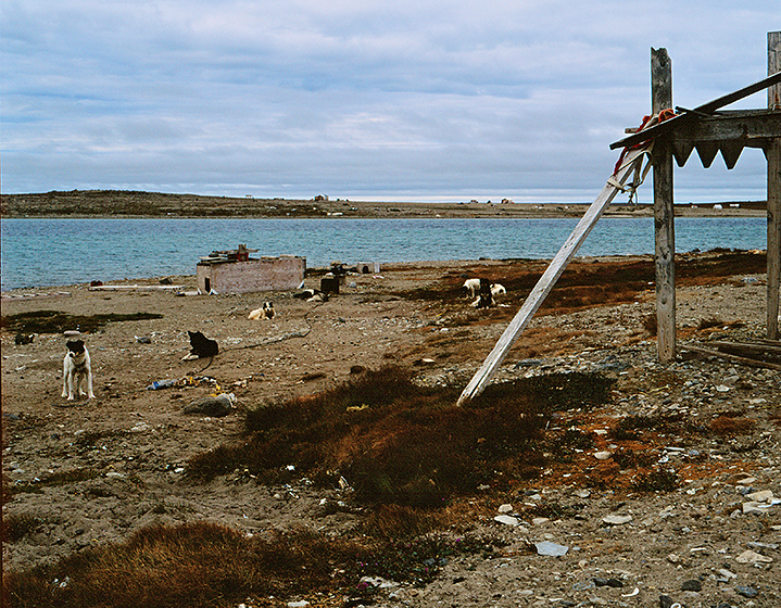
ARCTIC, #55: After our conversation with the Canadian mountie at the shoreline, Bill, John Bockstoce and the other guests head toward the central village to try and find John’s “relatives.” I am now free to work for awhile, so I begin by taking a stroll further along the shore. The village is truly “arctic” and we are well north of a treeline and any trees. Gjoa Haven is located on a large bay and houses stretch out from the town center and wrap themselves entirely around the shore of the bay. This is also a very different beach from the one we experienced several nights previously in Kugluktuk (post #45). The golden light and warming rays of the sun that evening, have now given way to a cold, blustery day with occasional rain, and the lovely swimming beach with a lifeguard station has, quite literally, gone to the dogs. Most villages have a very limited cash economy and things like snowmobiles and the gas it takes to run them are, not only hard to get, but cost a lot of money. Thus, villagers lead a more traditional life, and to hunt and travel in the winter, they often use sleds and dogs. Gjoa Haven is a big village. Most residents use a sled. There hundreds of dogs AND they are staked out on long chains along the shoreline. They get fed and cared for by villagers on ATV’s, and they serve as excellent guard, all of them howling in weird discordant harmony when something unexpected, like a polar bear, arrives. Or, in this case, me. Awhoo! Awhoo! Have YOU ever had hundreds of dogs howling at you? Like Odysseus and the Sirens, the sound will make you crazy, and it certainly did me, so I retreated a bit up the beach to quiet them down.
photograph(s) © copyright, ROBERT GLENN KETCHUM, 2017, @RbtGlennKetchum @LittleBearProd #LittleBearProd
Follow Robert Glenn Ketchum's Photographic Activism Online:
WEBSITE: http://www.robertglennketchum.com/
PINTEREST: http://www.pinterest.com/littlebearprod/
SOCIAL MEDIA by #LittleBearProd: http://www.LittleBearProd.com
Wednesday, August 23, 2017

ARCTIC, #54: Because John Bockstoce has “relatives” in Gjoa Haven, we are going to be ashore for several hours, and I am really excited because it will give me time to study the village a bit, rather than just running quickly around taking whatever pictures I can, which is what I have had to do on shorter visits elsewhere. There is a light rain falling on and off, and there is a cold, slight breeze. Curiously, as soon as our Zodiac hits the beach, we are confronted by a VERY large, armed Canadian (non-native) mountie on a 4-wheeler. He wants to know who we are and why we are here. When John identifies himself, it seems to console his suspicions, but he still informs us of the “rules’ of our behavior while in the village: If we have any alcohol on us, it goes back to “Itasca” immediately; if we have weapons, they must leave as well; if we brought things to “trade,” forget it - the villagers are no longer allowing amazing carvings and personal craft to be “traded” for booze or “trinkets.” Then he turns to me and wants to know the purpose of my pictures. I explain I have done much work in villages in Alaska and have published that material, but I have never been in an Arctic village, which I am sure is quite different, and I would simply like to make images that are good documents. I have no intent to make anybody look impoverished, starving, drunk, or otherwise. I just want to create pictures of what the village looks like to those that see it everyday. He comments that there is not much to see, but as long as I don’t have “some agenda,” I am free to go where I want and take pictures of whatever I choose. SO, we are off ! Aloha, Gjoa Haven !
photograph(s) © copyright, ROBERT GLENN KETCHUM, 2017, @RbtGlennKetchum @LittleBearProd #LittleBearProd
Follow Robert Glenn Ketchum's Photographic Activism Online:
WEBSITE: http://www.robertglennketchum.com/
PINTEREST: http://www.pinterest.com/littlebearprod/
SOCIAL MEDIA by #LittleBearProd: http://www.LittleBearProd.com
Wednesday, August 16, 2017

ARCTIC, #53: As the pilot is dining with staff in the galley, after the incredible sky-show-sunset, I wander down to have a beer with all of them and ask about the interesting repair on the bubble of his helicopter that seems to be making Bill Simon a bit nervous. The pilot tells me that the damage was done by someone who was careless with a fork-loader, and ran into his parked chopper, putting a big crack in the bubble near the bottom, left-side. This pilot makes most of his money flying assay samples from a mine in Yellowknife, so he does not have the income to casually replace the bubble, but he felt certain he had repaired it using “Iniut skills.” Working with some Native friends, he acquired reindeer sinew - the fiber in muscle meat that Natives use to build sleds and other things - and using a drill to make small holes, created a “sewn” system of lashes and stitches to bind the crack in the bubble closed. It sounded interesting to me, and when I repeat what I have learned to John Bockstoce, he comments that the sinew is stronger than any glue could ever be, and he has no apprehensions about the repair. Bill, however, is still pretty skeptical, so he suggests that since John and I are fine with it, we should be the first to go flying. John and I are good with that, but first Gjoa Haven. The sunset of the night before predicted weather was headed our way, and the color of the morning sky makes it clear that weather has arrived. It looks like our visit to the village is going to be a wet one.
photograph(s) © copyright, ROBERT GLENN KETCHUM, 2017, @RbtGlennKetchum @LittleBearProd #LittleBearProd
Follow Robert Glenn Ketchum's Photographic Activism Online:
WEBSITE: http://www.robertglennketchum.com/
PINTEREST: http://www.pinterest.com/littlebearprod/
SOCIAL MEDIA by #LittleBearProd: http://www.LittleBearProd.com
Wednesday, August 9, 2017

ARCTIC, #52: With introductions to staff and guests complete, our recently arrived helicopter pilot retreats to the galley for some food, and later a nap, as he has had a long flight to reach us. “Itasca” has now navigated past the “gap” between Victoria Island and King William, so the polar ice pack we could see is gone, and the waters around us are once again ice-free because we are protected by a landmass to our north. The windy turbulence of the morning has died down as well, but it is clear that weather is coming in. The pilot is “adjusting" and there is no need to fly today, but most of us expect to go flying, so one by one, we wander up to the flight deck to check out this very small helicopter. It will seat 3 people reasonably comfortably, and in shotgun, I will have a small window I can open from which to shoot, but in reality, the cockpit is a plexiglass bubble and you can see well in every direction. It is this bubble, however, that catches everyone’s interest. The front of the bubble, down near the runners beneath the copter, has clearly suffered enough damage to put a large crack in the plexiglass, and it appears that the crack has been “stitched-up” much like a patient in the hospital. This makes Bill Simon, in particular, very nervous about flying in something that “could fall apart.” His concerns arise again during our dinner conversations, so I take it upon myself to ask the pilot about this. In the meantime, cocktail glasses in hand, we all wander out onto the fantail deck to watch the evening “show.”
photograph(s) © copyright, ROBERT GLENN KETCHUM, 2017, @RbtGlennKetchum @LittleBearProd #LittleBearProd
Follow Robert Glenn Ketchum's Photographic Activism Online:
WEBSITE: http://www.robertglennketchum.com/
PINTEREST: http://www.pinterest.com/littlebearprod/
SOCIAL MEDIA by #LittleBearProd: http://www.LittleBearProd.com
Wednesday, August 2, 2017

ARCTIC, #51: The morning dawns relatively clear in Cambridge Bay, but there seems to be a cold wind building. As we pull anchor and head toward Gjoa Haven, the wind picks up, but except for some minor chop, the wave action does not. This is the reason. The wind is coming from the north and it is pushing the polar pack ice toward us. There are no waves because the ice suppresses wave action, but it also makes the breeze stunningly cold. I think our “cruise” is about to end if this is what it looks like where we are going. Before noon, the radio cracks on with communication from the copter that it will arrive shortly. The wind is blowing, and it is hard to hold “Itasca” truly steady, but this is an experienced Arctic pilot and he lands on the tiny pad without much effort. It is a REALLY SMALL helicopter, and when the pilot emerges, he is classic - unshaven, a little grimy and tired from his LONG flight, wearing at least 6 layers of clothing, and clearly a little stunned at the elegance of “Itasca,” and the fact that he is introducing himself to some guy that ran for President of the United States. Fitting his role perfectly, his amazement/amusement only lasts so long, and when introductions to all of us are done, he asks, “Hey, can I get some food and a beer?"
photograph(s) © copyright, ROBERT GLENN KETCHUM, 2017, @RbtGlennKetchum @LittleBearProd #LittleBearProd
Follow Robert Glenn Ketchum's Photographic Activism Online:
WEBSITE: http://www.robertglennketchum.com/
PINTEREST: http://www.pinterest.com/littlebearprod/
SOCIAL MEDIA by #LittleBearProd: http://www.LittleBearProd.com
Wednesday, July 26, 2017

ARCTIC, #50: Things are about to change, so viewing a map is once again useful. We have traveled to Cambridge Bay through the waterway that leads off the map to the left. Cambridge Bay is part of gigantic Victoria Island. For some time now our navigation has been relatively ice-free because we have been “protected” from the polar ice pack by the presence of that island to our north. As you can see here, when we leave Cambridge Bay, we are eventually exposed to waters that open to the north, and directly into the polar ice. It will be our first look at where we hope to find a route of passage. We will then continue east, slipping behind King William Island for a bit more protection. There is a two-fold purpose in this: one is that we hope to find more open water along the shoreline of the peninsula you see here that hosts the village of Taloyoak; the other is that John Bockstoce has “family” in Gjoa Haven, and we will stop there for an extended visit (several hours). In crossing from Cambridge Bay to Gjoa Haven, we will also bring on a helicopter and pilot that have flown out of Yellowknife to meet us. Things are about to get A LOT more interesting.
photograph(s) © copyright, ROBERT GLENN KETCHUM, 2017, @RbtGlennKetchum @LittleBearProd #LittleBearProd
Follow Robert Glenn Ketchum's Photographic Activism Online:
WEBSITE: http://www.robertglennketchum.com/
PINTEREST: http://www.pinterest.com/littlebearprod/
SOCIAL MEDIA by #LittleBearProd: http://www.LittleBearProd.com
Wednesday, July 19, 2017

ARCTIC, #49: We reach Cambridge Bay a little after midnight and the sun has just set. Staff goes ashore to perform various tasks, but John Bockstoce considers it a necessary pilgrimage to visit the remains of Roald Amundsen’s exploratory boat, “Maud,” so he, Bill Simon, and most of the other guests gear up for a late night Zodiac ride across Cambridge Bay to the inlet where the ruins lie half-sunken, but well preserved in the cold, Arctic water. Considering the hour, we are all in quite a good mood because we have been dining and drinking all night waiting to do this (kids who may be reading this should not consider this appropriate behavior to then go for a midnight ride in a Zodiac), thus, concerned about someone falling in, staff insists we all wear thermal suits - the night is cold and the water even colder. It is also very beautiful. Here Dr. Robert Leach and my cabin-mate and good friend, George Gowan, are having entirely too much fun. “Maud” is a weathered shipwreck, aground in shallow water at the end of an inlet. She is approachable, and also quite beautiful in the glow of the twilight. We try to take pictures of her, and each other standing on her, but most of the cheapy camera flashes do not carry far into the dark, so you really can not see the greater wreck. I have no flash either, other than one similar to theirs, so we do not get our “selfies” on “Maud,” but we do wake up some Inuit who do not like to sleep in the village during the summer months, so they camp out here. They are pretty sure we are just those crazy rich guys that showed up in the big boat lit like a Christmas tree, now anchored in the harbor.
photograph(s) © copyright, ROBERT GLENN KETCHUM, 2017, @RbtGlennKetchum @LittleBearProd #LittleBearProd
Follow Robert Glenn Ketchum's Photographic Activism Online:
WEBSITE: http://www.robertglennketchum.com/
PINTEREST: http://www.pinterest.com/littlebearprod/
SOCIAL MEDIA by #LittleBearProd: http://www.LittleBearProd.com
Wednesday, July 12, 2017

ARCTIC, #48: And what a sky it is !!! For some days now we have been navigating through expansive sounds and straits that have had no ice, so most of what I have seen on this voyage is the exchange of vapors between the sky above and the water beneath. Mirages, strange fogs, stunning weather displays, AND GREAT SKIES, tonight being another of them. Way back there, beneath the “god rays” is the mainland of Canada. WAY off to the right is the village of Kugluktuk where we went strolling on the village beach (post #45) just a few hours ago. Now, night and this weather are following us to Cambridge Bay. Staff expects to take on supplies and mail when we anchor, but John Bockstoce has convinced Bill Simon that we guests should all pay our respects to the ruins of Roald Admundsen’s boat, the “Maud” which is sunk in shallow water in one of the bay’s inlets. Thus, as we motor on, there is a good bit of activity as we prepare to go Zodiac exploring in the Arctic sometime after midnight with weather coming in. Whose idea is this?
photograph(s) © copyright, ROBERT GLENN KETCHUM, 2017, @RbtGlennKetchum @LittleBearProd #LittleBearProd
Follow Robert Glenn Ketchum's Photographic Activism Online:
WEBSITE: http://www.robertglennketchum.com/
PINTEREST: http://www.pinterest.com/littlebearprod/
SOCIAL MEDIA by #LittleBearProd: http://www.LittleBearProd.com
Wednesday, July 5, 2017

ARCTIC, #47: The light in the previous post was too good to resist, but you had to look closely to distinguish the tidal “bathtub” rings caused by isostatic rebound, I tried to point out. Here is a better look at that phenomenon. The Arctic has very little tidal action, so small waves and wind deposit material on the shore of the rising seabed/rebound island, and those deposits remain relatively undisturbed. With the ice weight now lifted off, these islands rise a few millimeters EVERY year. This rebound is ongoing all over the arctic and is spectacular when seen from the air which will happen for me for the first time, a few days from now. For the moment, however, we are heading to Cambridge Bay under a weather-rich sky. We pass numerous rebound islands, including this VERY large one (that thing has been “rising” for some time-that is a tall, STEEP beach!), but we see virtually no ice because we are “protected” from exposure to the polar pack by the presence to our north of huge Victoria Island. Cambridge Bay is on Victoria Island and we will take on fuel and other supplies there, but the guests will not go ashore, as Bill Simon and John Bockstoce are planning something else. Navigating forward, the night stays bright quite late and we will arrive and anchor around midnight. I choose to sit on deck and watch the evening sky swim by.
photograph(s) © copyright, ROBERT GLENN KETCHUM, 2017, @RbtGlennKetchum @LittleBearProd #LittleBearProd
Follow Robert Glenn Ketchum's Photographic Activism Online:
WEBSITE: http://www.robertglennketchum.com/
PINTEREST: http://www.pinterest.com/littlebearprod/
SOCIAL MEDIA by #LittleBearProd: http://www.LittleBearProd.com
Wednesday, June 28, 2017

ARCTIC, #46: The curfew siren calling the children of Kuglugtuk home for the evening was also our notice to return to “Itasca.” Bill Simon has learned from fishermen and hunters in the village that there is virtually NO ice between us and Cambridge Bay, so he is eager to keep moving in these open waters to make up time, and upon arriving back aboard we are told we should anchor in Cambridge Bay around midnight. The weather has been clear, but clouds are now beginning to occlude the sky, allowing an occasional “spotlight" to shine through on whatever is out there. Simon’s eagerness to press forward “at full speed” is tempered, however, by the advice of our ice pilot, who warns that we must still be vigilant although ice is no longer the danger. Since the polar cap began to retreat during climate change, massive amounts of ice weight have been lifted off the land. In some places, a phenomenon called isostatic rebound has begun to occur. The suppressed land actually begins to rise up. In many cases across the Arctic, new islands are forming. Some are quite small and flat as they have just begun, but others are more developed and have taken on both greater size and height. What I find especially interesting about them, are the striations along the shore that make them appear as if they have been drawn in topographical relief. These are “rings” around the shore of the island, created by tide deposit which is then lifted a small bit over the course of every year, allowing the water’s edge to begin forming a new line. This island, illuminated, clearly shows off those tidal ring lines. Other, NEWER islands, might not be so visible as they may still be slightly underwater, NOR will they be on ANY current maps, so although we have picked up the pace a bit, our captains are still as vigilant as ever.
photograph(s) © copyright, ROBERT GLENN KETCHUM, 2017, @RbtGlennKetchum @LittleBearProd #LittleBearProd
Follow Robert Glenn Ketchum's Photographic Activism Online:
WEBSITE: http://www.robertglennketchum.com/
PINTEREST: http://www.pinterest.com/littlebearprod/
SOCIAL MEDIA by #LittleBearProd: http://www.LittleBearProd.com
Wednesday, June 21, 2017

ARCTIC, #45: We navigate another hour in the cold, now crystal-clear air, and at about 7pm we come abreast of the village of Kugluktuk where there seems to be a great deal of activity, so Bill Simon decides we should take the time to visit, stretch our legs, and find out what is going on, and we go ashore. There are numerous boats in the water fishing just off a very nice sandy beach, and astoundingly, although the air is cold and the water nearly freezing, their are dozens of children swimming on that beach which also sports a lifeguard station. WHAT! Of course, we draw attention with our arrival. Pretty much everyone that is not fishing comes to check us out. Turns out, there is a run of Arctic char, hence all the boats out, and everyone else is watching, swimming, or just enjoying the “nice" evening. I know Bill will not spend much time here, but the light is so amazing, I just start running from place-to-place, trying to get a sense of what I might photograph. This effort, however, becomes a game as I am pursued by this crew. It becomes their entire purpose in life to appear in every picture I attempt. After awhile, I realize they are the picture. Quite a group. Interesting to see them immediately dash home when a curfew siren goes off, reminding them they have school the next day. That is also our signal to reboard “Itasca” and continue our journey to Cambridge Bay. The night is still young and the sky is clear (for the moment).
photograph(s) © copyright, ROBERT GLENN KETCHUM, 2017, @RbtGlennKetchum @LittleBearProd #LittleBearProd
Follow Robert Glenn Ketchum's Photographic Activism Online:
WEBSITE: http://www.robertglennketchum.com/
PINTEREST: http://www.pinterest.com/littlebearprod/
SOCIAL MEDIA by #LittleBearProd: http://www.LittleBearProd.com
Wednesday, June 14, 2017

ARCTIC, #44: Rather suddenly, the fog and mists that have surrounded us most of the day lift, as though we have passed from under a dark veil. As “Itasca” progresses, every few feet forward changes the light, changes the clarity,..changes EVERYTHING. Slowly our POV clears to the horizons and we can see the mainland of Canada distinctly. The sky is mottled with dense clouds high above us, and ahead of the boat we can see sunlight through a hole that appears to be opening in the clouds. We are moving toward that opening, AND it is also moving towards us, rather rapidly. As we come upon the edge of it, it becomes quite dramatic. We are passing through the actual wall of a cold front without storm turbulence (see the opposite of this, posts #17-27), and in the high altitude clouds, you can see the “wall” effect, where the moist air terminates and the cold, clear air begins. Almost immediately the temperature on deck drops 20 degrees.
photograph(s) © copyright, ROBERT GLENN KETCHUM, 2017, @RbtGlennKetchum @LittleBearProd #LittleBearProd
Follow Robert Glenn Ketchum's Photographic Activism Online:
WEBSITE: http://www.robertglennketchum.com/
PINTEREST: http://www.pinterest.com/littlebearprod/
SOCIAL MEDIA by #LittleBearProd: http://www.LittleBearProd.com
Wednesday, June 7, 2017

ARCTIC, #43: The day wears on and as we pass mid-afternoon, the grey gets a lot grey-er. We are a long way from sunset but we seem to have passed into a particularly dark and dense section of fog. Strangely, it is also thin enough directly above us that we can see the sun. It is as though I am looking through a pair of very dark glasses, but I am not wearing any. It is also very humid and drippy. Condensation forms on everything, chairs, deck rails, my lenses, my clothes - BUT, it continues to be eerily beautiful so I remain out in it, watching these strange surreal objects and lighting events swim by. Gabriel Garcia Marquez would have loved these moments. Dreary, dark or not, “Itasca” continues to carefully ply the waters through sounds and straits as Bill Simon hopes we can continue apace and quickly cover many miles that are relatively ice-free. Then, something happens. I am sure we have all heard the old saying that "it is darkest, just before the dawn." Well, check out next week...
photograph(s) © copyright, ROBERT GLENN KETCHUM, 2017, @RbtGlennKetchum @LittleBearProd #LittleBearProd
Follow Robert Glenn Ketchum's Photographic Activism Online:
WEBSITE: http://www.robertglennketchum.com/
PINTEREST: http://www.pinterest.com/littlebearprod/
SOCIAL MEDIA by #LittleBearProd: http://www.LittleBearProd.com
Wednesday, May 31, 2017

ARCTIC, #42: Late in the day, the luminous glowing fog (last post) dissipates, and is slowly replaced by a greying sky. Now the sky/water show begins anew. Instead of bergs looking like clouds, with nebulous colors and shapes, they suddenly became white, and clearly etched against the darker sky. Because fog still obscures the horizon line, the ice seems to be sculpture, floating in a suspended space. Bob Leach tells me he thinks it is “really weird, and I am sure glad I am not driving.” My sentiments exactly. I am sure out there somewhere is the end of the earth and we are going to sail off it. This incestuous little group of friends really needs further outside contact with the world. We are getting nuttier as the trip wears on.
photograph(s) © copyright, ROBERT GLENN KETCHUM, 2017, @RbtGlennKetchum @LittleBearProd #LittleBearProd
Follow Robert Glenn Ketchum's Photographic Activism Online:
WEBSITE: http://www.robertglennketchum.com/
PINTEREST: http://www.pinterest.com/littlebearprod/
SOCIAL MEDIA by #LittleBearProd: http://www.LittleBearProd.com
Wednesday, May 24, 2017

ARCTIC, #41: We hit a very bright point of the day, and although the fog did not burn off, it became blindingly radiant and seemed to glow. Of all that we had passed in the last few hours, this was finally strange and obvious enough to draw guests out onto the deck. Bill Simon, Bob Leach, and I walked to the bow to peer down at the ice, and the world surrounding us was luminous, like some kind of hi-key dreamscape. The three of us just stood and stared in silence for quite awhile, and then Bill turned to me and said, “We voted on whether you had gone off the edge or not and were just taking the same picture over and over, but now that I am out here, it is pretty amazing. I am glad I brought you along and that someone among us is actually paying attention."
photograph(s) © copyright, ROBERT GLENN KETCHUM, 2017, @RbtGlennKetchum @LittleBearProd #LittleBearProd
Follow Robert Glenn Ketchum's Photographic Activism Online:
WEBSITE: http://www.robertglennketchum.com/
PINTEREST: http://www.pinterest.com/littlebearprod/
SOCIAL MEDIA by #LittleBearProd: http://www.LittleBearProd.com
Wednesday, May 17, 2017

ARCTIC, #40: We can see the large icebergs on radar, but lesser ones do not register, so much of our navigating is slow and by sight. Some hours roll by and I am just lying on an outside deck in a bundle of fleece and wind-proofing, working myself into a shooting coma. About every 20mins, I take yet-another picture of water and sky. Simon and his guests occasionally come to the salon window to determine if I am unconscious, or have simply lost my mind. I have NOT lost my mind, but I have entered another world. Quiet, serene, the only sound is of the water as it slips by the hull. I consider how surreal and beautiful I find it, and then realize the two captains see it in a very different way. What I think is ethereal, they think is a danger to the boat. I am suddenly very glad to have the luxury of being a guest, so that I can just be a voyeur to the passage, and not the one responsible. I hope it stays that way.
photograph(s) © copyright, ROBERT GLENN KETCHUM, 2017, @RbtGlennKetchum @LittleBearProd #LittleBearProd
Follow Robert Glenn Ketchum's Photographic Activism Online:
WEBSITE: http://www.robertglennketchum.com/
PINTEREST: http://www.pinterest.com/littlebearprod/
SOCIAL MEDIA by #LittleBearProd: http://www.LittleBearProd.com
Wednesday, May 10, 2017

ARCTIC, #39: As the hours pass, the show around us continually changes with the fog thickening and thinning, and bergs of various sizes appearing cloud-like, indistinguishable from those in the sky and surrounding reflections. It is dreamlike. Natives in many cultures have words for “dreamtime.” This IS dreamtime. THIS is Arctic dreamtime! Bill Simon is probably working somewhere inside, and the other guests are either asleep, working out, or drinking. Bockstoce wanders out every once in awhile to “catch some air," but for the most part, it is cold and damp, so I am alone, and this passage becomes a slow and VERY surreal movie. I am sorry if this blog now drifts a bit into SKYSHOW, but when I am finished, you will have enjoyed the journey, so stay tuned, we will not be making Cambridge Bay as quickly as we hoped.
photograph(s) © copyright, ROBERT GLENN KETCHUM, 2017, @RbtGlennKetchum @LittleBearProd #LittleBearProd
Follow Robert Glenn Ketchum's Photographic Activism Online:
WEBSITE: http://www.robertglennketchum.com/
PINTEREST: http://www.pinterest.com/littlebearprod/
SOCIAL MEDIA by #LittleBearProd: http://www.LittleBearProd.com
Wednesday, May 3, 2017

ARCTIC, #38: Bill Simon planned this trip across the Northwest Passage to start LATE in the summer, on the cusp of fall, because research indicated that would be the point of greatest melt and likely to have the least amount of obstructive ice. However, beginning the voyage that late in the season also risks encountering the weather and ice of an early winter. Now that we were leaving Tuktoyaktuk and headed for Cambridge Bay, we hope to have protection from Arctic pack ice because we will be in the “shadow” of a HUGE Canadian island, Victoria. Simon thought we might “make good time” passing through as series of connected straits, but the problem is, these waters are not entirely ice-free, so without GREAT visibility, Capt. Jouning, now joined by ice pilot, Bruce Brophy, has no intention of doing any “full speed ahead” until we can SEE ahead. The flip side of having less ice is that we have warmer water, and the interaction of that warmer water with the increasingly colder fall air creates a low fog that is DENSE in front of us, but interestingly quite thin above us. While not great for navigating, I find myself bundled on the outdoor deck watching an ethereal world float by.
photograph(s) © copyright, ROBERT GLENN KETCHUM, 2017, @RbtGlennKetchum @LittleBearProd #LittleBearProd
Follow Robert Glenn Ketchum's Photographic Activism Online:
WEBSITE: http://www.robertglennketchum.com/
PINTEREST: http://www.pinterest.com/littlebearprod/
SOCIAL MEDIA by #LittleBearProd: http://www.LittleBearProd.com
Wednesday, April 26, 2017

ARCTIC, #37: With customs inspections behind us, and a day of meeting people and seeing places nearing an end, talk at the dinner table turns to what we are planning for the following day. We anticipate having a relatively ice-free run for awhile because we will be protected from polar floes by Victoria Island, which you can see occupies most of the upper-right in this map and is one of the largest islands in the world. Far to the left on the map, you can see the meanders of the Mackenzie River system, and at the mouth of the bay where the river enters the sea, is Tuktoyaktuk, our current position. We will leave here in the morning, heading east (to the right), around the peninsula of land, and hugging the lower coastline, we will travel through the channel below Victoria Island, heading for the village of Cambridge Bay, the last village designated to the far left on this map. This is a considerable distance and the run will take several days, so for the moment, Bruce Brophy, the ice pilot we have brought aboard, can have a short “vacation” before he has to go to work. AFTER Cambridge Bay, we expect conditions to become far more difficult and he will have a chance to us his skills. However, Bill Simon also has one more trick up his sleeve to help this journey, and we will make that connection after Cambridge Bay.
photograph(s) © copyright, ROBERT GLENN KETCHUM, 2017, @RbtGlennKetchum @LittleBearProd #LittleBearProd
Follow Robert Glenn Ketchum's Photographic Activism Online:
WEBSITE: http://www.robertglennketchum.com/
PINTEREST: http://www.pinterest.com/littlebearprod/
SOCIAL MEDIA by #LittleBearProd: http://www.LittleBearProd.com
Wednesday, April 19, 2017

ARCTIC, #36: Bill’s guests have many questions: How long has her family been here? What goes on in daily village life? What happens in the winter? Does she live “subsistence”? Because where she lives is SO foreign to our group, everyone is fascinated to hear her speak about what she views as “normal” existence. Although I am listening to this, I leave the questioning to the other guests, and I circle the group taking pictures. As I come to the chair behind her where she has placed her parka, I finally look closely at it, and I am transfixed. As an adventurer, I am VERY particularly about my gear and clothing, and I recognize something that suggests both style and function (hence I have often mentioned my use of Patagonia gear), so as I studied this parka I began to realize the design subtleties of seam placement and choice of furs. I take several pictures of the parka with flash, which suddenly makes me more apparent in the room, and she turns to me to ask if I have any questions. “I know you made this,” I said glancing at the parka, “So please tell me about all of the details that go into it.” Her response is a thesis, the long and short of which is that there is NOTHING about this that has not been sorely design tested, and EVERYTHING chosen in the construction is VERY specific. There are cloth layers, layers of lining, careful attention to seams that might leak cold, AND three different animal skins to complete protection around the openings. I am particularly interested that the especially long hairs of certain martin pelts are used to surround the face, because the long hairs keep her face from getting vapor frosted. Really! Perfect! She also notes that this is her light, more fashionable parka, and that she has a very different one for winter life. Now you know why Patagonia catalogs have all of those technical explanations about their product function, it is part of the history of GREAT clothing makers.
photograph(s) © copyright, ROBERT GLENN KETCHUM, 2017, @RbtGlennKetchum @LittleBearProd #LittleBearProd
Follow Robert Glenn Ketchum's Photographic Activism Online:
WEBSITE: http://www.robertglennketchum.com/
PINTEREST: http://www.pinterest.com/littlebearprod/
SOCIAL MEDIA by #LittleBearProd: http://www.LittleBearProd.com
Wednesday, April 12, 2017

ARCTIC, #35: It is impossible to be traveling with a former US presidential candidate and Secretary of the Treasury (William Simon), and a well known Arctic author of many books (John Bockstoce) and not have everyone know we are out here and headed their way, ESPECIALLY remote Native villages you might mistakenly assume have little news. Our arrival in Tuktoyaktuk not only brings out the Canadian Coast Guard and border police, but people from the village come out as families in their boats to circle and study “Itasca,” and wave to us. The public radio station in the village also wants to do an interview that will be broadcast throughout Canada and the new Inuit nation, so Bill obliges. The interviewer comes aboard the next morning during a rainy, cold, blustery squall, and before our eyes, reduces her size by 1/2 by taking off her huge parka and several other layers. I have now been working in Alaska long enough to appreciate a good conversation with a Native, and to have some understanding that they approach the world from a VERY different perspective than we do, so I was eager to here where this interview might go - two VERY DIFFERENT worlds are meeting here. The interviewer has many thoughtful questions I can tell that Bill is enjoying, and most pertain to the purpose of the expedition and why he chose to go at this time. When Bill acknowledges he has been studying ice charts for 5-years and sees that CLIMATE CHANGE is causing less ice to block the Northwest Passage, so now might be the first chance for a private yacht to cross in a single season (without getting “frozen over” to the next year), she laughs and comes back that she is surprised to here such a “famous” Republican admit belief in global warming. WE ALL think that is pretty funny. She is very engaging. They also speak of future development in the Arctic. When she closes, she will join us on our day of site visits but she wants to tell us that “friends” have told her we will face some difficult broken ice in the James Ross Strait a few days from now unless the weather changes. She also wants to know if any of us have questions of her, and of course, we all do.
photograph(s) © copyright, ROBERT GLENN KETCHUM, 2017, @RbtGlennKetchum @LittleBearProd #LittleBearProd
Follow Robert Glenn Ketchum's Photographic Activism Online:
WEBSITE: http://www.robertglennketchum.com/
PINTEREST: http://www.pinterest.com/littlebearprod/
SOCIAL MEDIA by #LittleBearProd: http://www.LittleBearProd.com
Wednesday, April 5, 2017

ARCTIC, #34: It seems to take forever to be equipment checked by the Canadian border patrol, and some of it is quite serious for the captain and staff, but for all of us in the upstairs salon, it is a comedy. We are all way overheated and awkwardly stuffed into survival suits so we look like the poached lobsters that we are. Dr. Rita Mathews gets down on the floor to put her suit on, and then cannot get up. Bockstoce has begun a rambling banter with the officers about choosing to die by alcohol, rather than floating in Arctic waters dressed so ridiculously. Then finally, we pass inspection and are “free to go.” Having been aboard for about 10-days now, we are all eager to get our feet on land, visit Tuktoyaktuk, and explore the archeological sites. Interestingly, once we do land with the zodiac and step ashore, most of us stumble and walk clumsily, and one person even feels “seasick.” We are so accustomed to walking with the motion of the ship, solid ground nows seems a little disorienting. It is a “nice” day with minimal rain, so the stroll about the village is enjoyable and it feels good to get some land-based exercise.
photograph(s) © copyright, ROBERT GLENN KETCHUM, 2017, @RbtGlennKetchum @LittleBearProd #LittleBearProd
Follow Robert Glenn Ketchum's Photographic Activism Online:
WEBSITE: http://www.robertglennketchum.com/
PINTEREST: http://www.pinterest.com/littlebearprod/
SOCIAL MEDIA by #LittleBearProd: http://www.LittleBearProd.com
Wednesday, March 29, 2017

ARCTIC, #33: The coldwater float suits are thick, thermal neoprene, with a single-seam zipper that goes from the crotch up the front to your cheeks. The suit has “closed” arms with gloves, a very tight hood with a 70% facemask, and the legs have booties. Once in the suit and properly zipped-up, only your eyes show. The trick is GETTING IN the suit! As the gods would have it, it was also a very warm day to make this process all the more uncomfortable. There is NO DOUBT you are much warmer in the suit, which is intended to keep you floating and alive in frigid waters until you can be rescued. EVERYONE struggled and sweated to get in their “lobster costume.” John being a big guy, and probably a little inebriated, was leaning on the bar trying to get his feet situated and the suit fully pulled up when, from under a sweaty brow, he could not resist asking our presiding immigration officer, “If Itasca is sinking, and I succeed in getting this f*#%ing suit on and jumping in the water, how long will it keep me alive?” To which the constable replied, “Probably about 30 minutes or so.” To which John responded, “If it is all the same to you, I would rather not bother with the suit. I will just sit here and consume the rest of my rum before Itasca goes down. Once in the water, I will probably survive as long as anyone else because of all the alcohol in my blood, and I will be A LOT happier!” I’m with John! The mountie was not amused.
photograph(s) © copyright, ROBERT GLENN KETCHUM, 2017, @RbtGlennKetchum @LittleBearProd #LittleBearProd
Follow Robert Glenn Ketchum's Photographic Activism Online:
WEBSITE: http://www.robertglennketchum.com/
PINTEREST: http://www.pinterest.com/littlebearprod/
SOCIAL MEDIA by #LittleBearProd: http://www.LittleBearProd.com
Wednesday, March 22, 2017

ARCTIC, #32: I am sorry the type is so small, but this map describes a large expanse of ocean and coast. We are traveling east, from left-to-right. We left the North Slope of Alaska and crossed the border into Canada where you see the green section indicating Ivvavik National Park. As we continued past the park, we turned northeast, and navigated around the large delta of the Mackenzie River, past Kendall Island Bird Sanctuary and into the large bay in the eastern delta that hosts the Native village of Tuktoyaktuk, and National Historic Site, Kittigazuit. We drop anchor offshore of “Tuk” and are boarded by Canadian Coast Guard to be “processed.” When they have finished, we will have a visitor, a friend of John’s who is going to do an interview with Bill Simon about our trip, AND she will join us afterward in a tour of some historical archeological sites. However, before any of that takes place, we must prove to the “mounties” that we know how to don our coldwater float suits and make them function. Everybody assemble in the upstairs salon! This is going to be a very funny cocktail hour!
photograph(s) © copyright, ROBERT GLENN KETCHUM, 2017, @RbtGlennKetchum @LittleBearProd #LittleBearProd
Follow Robert Glenn Ketchum's Photographic Activism Online:
WEBSITE: http://www.robertglennketchum.com/
PINTEREST: http://www.pinterest.com/littlebearprod/
SOCIAL MEDIA by #LittleBearProd: http://www.LittleBearProd.com
Wednesday, March 15, 2017
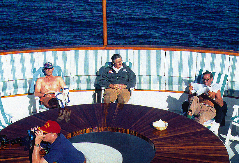
ARCTIC, #31: Unlike the collective portrait of the last post, this is what the fantail deck looks like on most sunny days. In the lower left, John Bockstoce is keeping an eye out for “the Mounties” because he knows Canadian Coast Guard will board us sometime soon to check our papers, our planned route, and our safety gear. Just above John, you can see that I am really working hard. “Barb” and I are just enjoying the warm, clear morning. Bill Simon is as well, but he IS Bill Simon because he works all of the time, so even while busily “arctic tanning,” he is pouring over balance sheets of some company he is thinking about buying. We will soon stop at the small Native village of Tuktoyaktuk where we will complete our passage through Canadian customs and meet some of the residents of the village, whom John knows from prior visits.
photograph(s) © copyright, ROBERT GLENN KETCHUM, 2017, @RbtGlennKetchum @LittleBearProd #LittleBearProd
Follow Robert Glenn Ketchum's Photographic Activism Online:
WEBSITE: http://www.robertglennketchum.com/
PINTEREST: http://www.pinterest.com/littlebearprod/
SOCIAL MEDIA by #LittleBearProd: http://www.LittleBearProd.com
Wednesday, March 8, 2017

ARCTIC, #30: With our sunny break, it gives me an opportunity to introduce nearly all of the guests with whom I am traveling, so bear with me because it is a VERY interesting group. Starting from left to right, (and sporting a ponytail because I have inspired him) is doctor Robert Leach, an orthopedic surgeon and chief doctor of the US Olympic Committee, which Bill Simon (not in picture) is part of as well. Next to Robert is my good friend, and bunkmate for this voyage, George Gowan. George is a distinguished New York attorney I met when I was working on my Hudson River commission, and he and his wife, Marcia, have been good friends every since. It was George that first suggested to Bill Simon that I should be the photographer to this expedition. (TY, George!) Doctor Rita Mathews sits at the center of this image and is a prominent marine biologist, currently serving as vice-president of The Explorers Club of New York, of which many of us are also members. Not in the picture is doctor John Loret, also a marine biologist and presently serving as President of the Explorers Club. The two of them are doing food-chain, and Pacific-Atlantic migration research using an underwater ROV (remote operating device). John Bockstoce, who has his back to us, is a distinguished arctic traveler, writer, historian, and archaeologist. He is also VERY FUNNY! There is a rumor he has a mixology degree as well. Next to John is Bill Langan, an internationally known boat designer and sailor, who helped Bill create “Itasca,” and who also won the Fastnet Race in 1993. Lastly, to the far right (no pun intended) is one of Bill Simon’s best friends and investment partners, Ettore Barbatelli. Bill and I are the missing components of this ensemble.
photograph(s) © copyright, ROBERT GLENN KETCHUM, 2017, @RbtGlennKetchum @LittleBearProd #LittleBearProd
Follow Robert Glenn Ketchum's Photographic Activism Online:
WEBSITE: http://www.robertglennketchum.com/
PINTEREST: http://www.pinterest.com/littlebearprod/
SOCIAL MEDIA by #LittleBearProd: http://www.LittleBearProd.com
Wednesday, March 1, 2017

ARCTIC, #29: For the moment, however, we ARE ice-free, and with every passing minute it grows warmer AND more glassy. The surface of the ocean is a stunning abstract display of sky and cloud reflections shimmering and changing with every ripple and roll. We have all come out on to the fantail to enjoy the sun, and there are some that have even seen the lovely day as a reason to have an early morning toast - and I don’t mean from a toaster - although, later they would be toasted. (sorry about that, it was to good to miss, AND it is true). As I sat there watching it all pass by, I had started the morning with a 2-panel panoramic image, so I guess I was in a “multiples mode,” and I suddenly realized I was about to fall into another “black hole for film.” The amazing glassy water could not be described in any single picture, it would be served by numerous ones displayed together. How many pictures that would take was yet-to-be-determined, but once the shutter clicked, it was about 1/2 before I regained consciousness. Apparently I took quite a few, and this is what I chose to work with because of how they seemed to “fit/flow” together - WHO KNOWS! Now, many years later, I see other pleasing combinations as well, BUT for all the “artistic” concerns I might have had then, or now, the most important fact, whether I took pictures or not, is that I was standing on that deck, and this was happening to me in REAL TIME!!!
photograph(s) © copyright, ROBERT GLENN KETCHUM, 2017, @RbtGlennKetchum @LittleBearProd #LittleBearProd
Follow Robert Glenn Ketchum's Photographic Activism Online:
WEBSITE: http://www.robertglennketchum.com/
PINTEREST: http://www.pinterest.com/littlebearprod/
SOCIAL MEDIA by #LittleBearProd: http://www.LittleBearProd.com
Wednesday, February 22, 2017

ARCTIC, #28: Awakening from dreams of sky and clouds, I grab some coffee and head onto the now VERY sunny fantail deck to be greeted by this! SKYSHOW for breakfast! The wild weather of the previous evening has given way to a relatively warm, “clear” morning with a stunning display of clouds, AND (as importantly) crystal clear views to the horizon that show little or no ice. We have already passed into “Canadian” waters, and the storm occurred as we navigated past Ivvavik National Park on our approach to the massive delta of the Mackenzie River. The Mackenzie is the largest and longest river system in Canada, and is only exceeded by the Mississippi in all of North America. Our open, ice-free water is due to the tremendous outflow of the river that is warmer than the ocean and holds the encroaching ice at bay. We will swing to the east as we navigate around the delta, heading for the village of Tuktoyaktuk where we will pass through Canadian customs, visit nearby, historically important, Herschel Island, and bring aboard a registered ice-pilot that will advise Captain Jouning as we go forward. Apparently this “ice-free” condition is not going to last very long.
photograph(s) © copyright, ROBERT GLENN KETCHUM, 2017, @RbtGlennKetchum @LittleBearProd #LittleBearProd
Follow Robert Glenn Ketchum's Photographic Activism Online:
WEBSITE: http://www.robertglennketchum.com/
PINTEREST: http://www.pinterest.com/littlebearprod/
SOCIAL MEDIA by #LittleBearProd: http://www.LittleBearProd.com
Wednesday, February 15, 2017

ARCTIC, #27: Even though it is approaching fall season and the days are growing shorter, there is still a considerable “lingering” twilight in that zone between long Arctic summer days, and long Arctic winter nights. Our arcos roll cloud-glacial mirage-Renaissance sunset evening spanned a good bit of time as it unfolded, but the show was not quite over. In one spectacular, final burst, the slowly clearing weather opened another of those holes in the cloud cover that allowed the sun to shine directly down on the surface of the water creating a true “golden spot.” If the one I posted in #23 was more difficult to see, this is pretty hard to miss! Although I continued to stay on deck for awhile, and I took a few more pictures, THIS was closure to the evening, and when I lay in my bed drifting into sleep, I could see vignettes of sky and clouds that immersed us, flashing across my subconscious mind, and I wondered what the next day might bring.
photograph(s) © copyright, ROBERT GLENN KETCHUM, 2017, @RbtGlennKetchum @LittleBearProd #LittleBearProd
Follow Robert Glenn Ketchum's Photographic Activism Online:
WEBSITE: http://www.robertglennketchum.com/
PINTEREST: http://www.pinterest.com/littlebearprod/
SOCIAL MEDIA by #LittleBearProd: http://www.LittleBearProd.com
Wednesday, February 8, 2017

ARCTIC, #26: We have entered the “theater” of the Arctic, and now the show is going on all around us. The previous post was from the stern of the boat, this is looking in front of us, off of the bow. At this moment I can pretty much point my camera in ANY direction and there is something going on - Renaissance skies, mirages, passing rain curtains, god-rays coming out of the clouds and and sweeping the sea like a searchlight - we all just walk about the decks in the frigid air with our mouths open. We are now headed into Canada, and perhaps we have already crossed the invisible border, but no matter, although we do not know it yet, tonight we slipped further into the extraordinary realm of the Arctic, and things are only going to be more strange-beautfiul from here on out.
photograph(s) © copyright, ROBERT GLENN KETCHUM, 2017, @RbtGlennKetchum @LittleBearProd #LittleBearProd
Follow Robert Glenn Ketchum's Photographic Activism Online:
WEBSITE: http://www.robertglennketchum.com/
PINTEREST: http://www.pinterest.com/littlebearprod/
SOCIAL MEDIA by #LittleBearProd: http://www.LittleBearProd.com
Wednesday, February 1, 2017

ARCTIC, #25: Standing on the fantail of “Itasca” and watching our wake ripple off through the calm waters, we have turned more to the north and the mainland of Alaska is retreating from view to merge with the evening sky. The last few hours have been as good a light show as I have ever seen (and Kaleidescope and The Fillmore used to put on some great ones), and the sky has transitioned from one thing to another so frequently I had no idea so much had happened until I reviewed my film. None of us could be sure how long this trip would take, so I brought a lot of film but I still had to “ration” using it because there was no knowing what we might encounter. We were not even one week out and I must have dozens of ice-fog and sky-weather shots. Tonight was a “black hole” for my film stash. Just to keep it going, the Renaissance painters suddenly show up and decorate the sky anew. Actually, if they could have seen THIS sky, more of them would have turned to sculpture, LOL!
photograph(s) © copyright, ROBERT GLENN KETCHUM, 2017, @RbtGlennKetchum @LittleBearProd #LittleBearProd
Follow Robert Glenn Ketchum's Photographic Activism Online:
WEBSITE: http://www.robertglennketchum.com/
PINTEREST: http://www.pinterest.com/littlebearprod/
SOCIAL MEDIA by #LittleBearProd: http://www.LittleBearProd.com
Wednesday, January 25, 2017

ARCTIC, #24: As the rain squalls passed and the sky opened up to the glow of the setting sun, the cold front brought incredibly clear air with it. You could quite literally see to the edge of the earth, which is the very straight dark line in this picture just below the dramatic “bank of clouds." Well, those are NOT REALLY CLOUDS. There ARE hazy, wispier clouds at higher elevation, but that “bank” of them lit by the late Arctic light IS A MIRAGE. There is NOTHING there. If we turned our boat to approach this, at some point it would simply vaporize in front of us. Early Arctic explorers sometimes thought these mirages were cliffs of glacial ice coming off of uncharted landforms, which they would sail toward, only to have it vanish as they approached. If I remember correctly, John invented some kind of rum drink this evening to commemorate this mirage and the passing of the arcus cloud. Don’t go away, however, the night is still young and the sky has come out to play.
photograph(s) © copyright, ROBERT GLENN KETCHUM, 2017, @RbtGlennKetchum @LittleBearProd #LittleBearProd
Follow Robert Glenn Ketchum's Photographic Activism Online:
WEBSITE: http://www.robertglennketchum.com/
PINTEREST: http://www.pinterest.com/littlebearprod/
SOCIAL MEDIA by #LittleBearProd: http://www.LittleBearProd.com
Wednesday, January 18, 2017

ARCTIC, #23: Looking behind our boat in the direction of the continental shoreline, there was still little visibility because even though the arcus cloud had rolled past us, the weather above it was ongoing. The sky was slowly opening but squalls continued to blow by. As the storm progressed, it began to clear and some very confusing light displays occurred. At the horizon in this image, it may appear that there is a black line mirage, but the “black line” separation is being caused by a glow of reflection coming off the ocean surface, directly beneath an opening in the clouds that is letting sunlight through. These “golden spots” would open and close around us for many minutes as the storm continued to pass and lift off, and I DO mean lift off! As the last of these rain curtains passed, much like in a theater, the “curtain” went up. Behind it was a stunning reveal.
photograph(s) © copyright, ROBERT GLENN KETCHUM, 2017, @RbtGlennKetchum @LittleBearProd #LittleBearProd
Follow Robert Glenn Ketchum's Photographic Activism Online:
WEBSITE: http://www.robertglennketchum.com/
PINTEREST: http://www.pinterest.com/littlebearprod/
SOCIAL MEDIA by #LittleBearProd: http://www.LittleBearProd.com
Wednesday, January 11, 2017

ARCTIC, #22: The amazing arcus cloud swept over us just as my colleague, John Bockstoce, and I got through the salon door and off the outside deck. Hail pounded down, and the windows rattled from the high wind gusts. For a few moments it got VERY dark, and the clatter of rain and hail was deafening. Then, complete silence. The downpour and the weather turbulence ceased abruptly, and it began to brighten. We all went back out on deck to watch this. Like a giant rolling pin, this cloud had come from behind us, overtaking us explosively, and now it is just continuing to tumble off across the vast expanse of the Beaufort Sea. It has left “Itasca” with a deck covered by hail, and the temperature has dropped about 20 degrees. The frigid temperature in which we are now standing makes it pretty clear the roll cloud marked the leading edge of a cold front. We had begun this trip in August, relatively late in the Arctic season, and very likely this storm signaled the arrival of more winter-like weather.
photograph(s) © copyright, ROBERT GLENN KETCHUM, 2017, @RbtGlennKetchum @LittleBearProd #LittleBearProd
Follow Robert Glenn Ketchum's Photographic Activism Online:
WEBSITE: http://www.robertglennketchum.com/
PINTEREST: http://www.pinterest.com/littlebearprod/
SOCIAL MEDIA by #LittleBearProd: http://www.LittleBearProd.com
Wednesday, January 4, 2017

ARCTIC, #21: Within minutes the roll cloud was upon us. Now nearly overhead, the most visible part of the cloud is the feathery underbelly I mentioned in the last post. I am not sure exactly why this happened, but as the cloud passed over the sea ice, the ice “lit-up” in a vibrant neon blue color, returning to white after the cloud passed. Perhaps it was light waves of color from the cloudshadow that caused the brief glowing color change, but the evening has been SO WEIRD so far, who can really be sure of anything, or why any of this stuff is happening. Mirages, roll clouds? Amazingly, the night is young and there is a good deal more that is going to happen. At the moment, however - in fact, within seconds of taking this shot - John and I beat a brief, hasty retreat inside as the hail promised by Captain Jouning did appear and began pelting us. Besides, now OUR drinks needed refreshing!
photograph(s) © copyright, ROBERT GLENN KETCHUM, 2017, @RbtGlennKetchum @LittleBearProd #LittleBearProd
Follow Robert Glenn Ketchum's Photographic Activism Online:
WEBSITE: http://www.robertglennketchum.com/
PINTEREST: http://www.pinterest.com/littlebearprod/
SOCIAL MEDIA by #LittleBearProd: http://www.LittleBearProd.com
Wednesday, December 28, 2016

ARCTIC, #20: With each cloud merger the roll cloud broadened across the horizon AND seemed to sink closer to it. It was now directly behind ”Itasca” and clearly moving much faster than we were as it “tumbled” across the surface of the Beaufort Sea. As it approached, you could feel the temperature dropping and the wind picking up, gusting around us and buffeting us from constantly changing directions. To me it felt like we were in some sort of vortex of complete weather chaos. John and I were in full gear, so we held our ground on the outside deck and indulged ourselves in the amazing light show. The roll cloud had strange morphing of its texture as it spun - the upper half of the cloud was a configuration of clearly defined shapes moving around as they circulated in the spinning motion. Underneath the cloud was entirely different, gauzy, diaphanous, and at times appearing “feather-like” as you will see.
photograph(s) © copyright, ROBERT GLENN KETCHUM, 2016, @RbtGlennKetchum @LittleBearProd #LittleBearProd
Follow Robert Glenn Ketchum's Photographic Activism Online:
WEBSITE: http://www.robertglennketchum.com/
PINTEREST: http://www.pinterest.com/littlebearprod/
SOCIAL MEDIA by #LittleBearProd: http://www.LittleBearProd.com
Wednesday, December 21, 2016

ARCTIC, #19: The strange clouds spinning like horizontal tornadoes above us began to join one another, building in volume and seeming to lower closer to the horizon. The weather above and behind them was still spots of sunlight appearing between cold, howling squalls of rain, but THIS cloud was something very different. As these mergers occurred, the rolling, tumbling cloud grew to span the entire horizon. As we all stood there gawking, the captain of “Itasca,” Alan Jouning joined us on the deck to have a look. He said we were watching an Arcus roll cloud forming as a “wave” in advance of a cold front that was coming directly at us. Bill Simon immediately wanted to know what that meant, and Alan suggested that when the cloud passed we might want to go inside because he thought the front was SO cold it might hail, but he assured Bill it would be a brief burst of weather and it represented no danger to our voyage. At that point Bill announced this news worthy of “refreshing” his drink, and he and most of the others retired inside once again. The arctic author, John Bockstoce, and I remained, staring in awe as this creature continued to grow and get darker, and yes, Alan was right - it was coming directly at us.
photograph(s) © copyright, ROBERT GLENN KETCHUM, 2016, @RbtGlennKetchum @LittleBearProd #LittleBearProd
Follow Robert Glenn Ketchum's Photographic Activism Online:
WEBSITE: http://www.robertglennketchum.com/
PINTEREST: http://www.pinterest.com/littlebearprod/
SOCIAL MEDIA by #LittleBearProd: http://www.LittleBearProd.com
Wednesday, December 14, 2016

ARCTIC, #18: Dark storm clouds, weird funnel clouds, lightening over the Brooks Range, short, fierce rain squalls, and VERY cold blasts of high wind - NOW things are about to get truly strange. If you look carefully at the horizon, you will see multiple layers: in the shadowy distance, some foothills appear from the haze of weather, BUT THEY APPEAR TO BE RESTING on what is, in fact, a very intense “black line” mirage. If you view this in a large enough version, you will also see a very fine line BELOW the black line mirage. That “line” is actually a long strip of exposed land forming a flat skinny island. Amazing as it is, however, the mirage is a distraction because the real excitement is overhead and just about to “go off.” Note the cloud extending from the upper right. It is another of those similar to the last post that seems to be forming BENEATH the layer of rainy weather. Think of it as being a horizontal tornado. As we watched it and several of the others, they seemed to be rolling, spinning, and as they did so, they began to grow in both volume and length.
photograph(s) © copyright, ROBERT GLENN KETCHUM, 2016, @RbtGlennKetchum @LittleBearProd #LittleBearProd
Follow Robert Glenn Ketchum's Photographic Activism Online:
WEBSITE: http://www.robertglennketchum.com/
PINTEREST: http://www.pinterest.com/littlebearprod/
SOCIAL MEDIA by #LittleBearProd: http://www.LittleBearProd.com
Wednesday, December 7, 2016

ARCTIC, #17: I do have one more mirage for you, but getting to it is its own unique journey. It began after a rainy day cruising off of the North Slope, headed toward the border with Canada. As dusk approached, the weather began to clear, and thinking there might be a sunset, we all poured cocktails and went out onto the fantail deck. The sky began to open above the Brooks Range but remnants of the weather remained above us, and as we stood there gazing about, I noticed these strange, horizontal dark clouds forming beneath the clouds overhead. Brief intense bursts of cold wind seemed to pick-up, and all of us could sense something was happening, but no one was sure what that was. Occasionally a squall would drive us back inside, but it was clear “a movie” was unfolding, and none of us wanted to miss it, so we would just refill our cocktails glasses and return when the rain stopped. Besides the liquor, we were also adding layers to our clothing as the temp was definitely going down.
photograph(s) © copyright, ROBERT GLENN KETCHUM, 2016, @RbtGlennKetchum @LittleBearProd #LittleBearProd
Follow Robert Glenn Ketchum's Photographic Activism Online:
WEBSITE: http://www.robertglennketchum.com/
PINTEREST: http://www.pinterest.com/littlebearprod/
SOCIAL MEDIA by #LittleBearProd: http://www.LittleBearProd.com
Wednesday, November 30, 2016

ARCTIC, #16: “And now for something completely different!” Many, many miles and hours ago, we passed the last of the Prudhoe Bay facilities as we moved east toward the Canadian border. The days have been relatively clear which has generated several different kinds of mirages shown you in previous posts. If you read what I write, you might well have found the Golden Gate Bridge story from the last post just a little too much, however, and be inclined to ask, “where is the picture?” Fact is, the “bridge” mirage happened so quickly and passed, I did not get a picture. Today is another story. This is a Fata Morgana. This also lasted for hours. This shot is with my longest lens, but in the high-powered binoculars you could see great detail. What you could see are people moving around, and trucks and cars driving through the road complex of Prudhoe Bay which is now actually over the curve of the horizon - in the opposite direction!!!!!! After a considerable amount of time studying, staring, and cawing about this, it was agreed by all that liquor should be served and consumed at lunch.
photograph(s) © copyright, ROBERT GLENN KETCHUM, 2016, @RbtGlennKetchum @LittleBearProd #LittleBearProd
Follow Robert Glenn Ketchum's Photographic Activism Online:
WEBSITE: http://www.robertglennketchum.com/
PINTEREST: http://www.pinterest.com/littlebearprod/
SOCIAL MEDIA by #LittleBearProd: http://www.LittleBearProd.com
Wednesday, November 23, 2016

ARCTIC, #15: As you have seen, the black line mirage has a distinct, defined shape, and then there is a variation that looks more cloud-like. Now, Itasca is navigating just offshore of the North Slope, nearing the border with Canada, and if you examine the distant shore you will see that it is either steep cliffs or walls of glacial ice. The glacial ice seems most likely because the sun is glistening off of it in the same way it is glistening off of the water. Unlike other mirages that, until now, have been more fleeting, we have been motoring parallel to this “shoreline” for several hours. Most of that time it has appeared as a dark landform, but now in the setting sun, parts of it are shimmering where the light is reflecting off of the “ice.” REALITY CHECK! The shoreline we are running parallel to is on the other side of the boat. This POV is directly out into the vastness of the ice-covered Arctic Ocean - there is no shoreline out there, there are no glaciers, there are no clouds - there ARE just a lot of light rays bouncing around in some VERY WEIRD ways.
photograph(s) © copyright, ROBERT GLENN KETCHUM, 2016, @RbtGlennKetchum @LittleBearProd #LittleBearProd
Follow Robert Glenn Ketchum's Photographic Activism Online:
WEBSITE: http://www.robertglennketchum.com/
PINTEREST: http://www.pinterest.com/littlebearprod/
SOCIAL MEDIA by #LittleBearProd: http://www.LittleBearProd.com
Wednesday, November 16, 2016

ARCTIC, #14: Now things are getting a bit more complex. It is a bright, clear day. A “black line” mirage has formed ABOVE the surface of the ocean. It is less clearly defined than the previous two I have shown you (posts #12 & #13), and appears more cloud-like. In the middle of this image, a similarly cloud-like mirage has overlain the black line and appears to have extended itself to the surface of the ocean, making this a compound mirage as two different ones are happening at the same time. Mirages such as this second “layer” often took on the shape of the cloud after an atomic test, so we referred to these as “mushroom cloud” mirages. Again, I restate - in actuality there is NOTHING out there on the horizon. How a mirage occurs is quite interesting because the viewer must arrive at the “lens point” to see the mirage. Sometimes we would be sitting on the upper outside deck watching the Arctic pass by, and there would be a shimmer in the air at the horizon. As the boat moved, the image might get clearer, or it might go away depending on our relationship to the lens point. One day, well past Prudhoe Bay, navigating along the shoreline of the North Slope, we were all taking in the view when a mirage began. It seemed to be some bright orange piece of architecture - a part of a building, or maybe a wall. It flickered in and out, never truly revealing itself, and all of us were busy speculating as to what we were seeing. Then, for a few very fleeting moments, it became clear that we were looking at one of the steel towers that support the Golden Gate Bridge, only this one was rising from the waters of the Beaufort Sea. And, then it was gone! There was a lot of braying aboard after that.
photograph(s) © copyright, ROBERT GLENN KETCHUM, 2016, @RbtGlennKetchum @LittleBearProd #LittleBearProd
Follow Robert Glenn Ketchum's Photographic Activism Online:
WEBSITE: http://www.robertglennketchum.com/
PINTEREST: http://www.pinterest.com/littlebearprod/
SOCIAL MEDIA by #LittleBearProd: http://www.LittleBearProd.com
Wednesday, November 9, 2016

ARCTIC, #13: In the last post I pointed out that early Arctic explorers would see these mirages and think they were land forms or glaciers (pictures of those will follow), but that last shot of a black line mirage was SO distinct, it just did not look real - I repeat, I did NOT do that with Photoshop. However, things change very quickly in the Arctic and several minutes after making that image, the diurnal fog above the ocean surface began to obscure parts of that perfect black line. NOW you can see why explorers were easily confused. This very clearly looks like a peninsula of land that comes into the frame from the right and terminates before reaching the left side of the picture. "Since this is NOT on any chart, let’s sail over there and investigate this" - ONLY THERE IS NOTHING THERE, ABSOLUTELY NOTHING - just more of the Beaufort Sea. Because all of us witnessed numerous events like this, you can imagine that we are pretty happy that we have sophisticated navigational radar!
photograph(s) © copyright, ROBERT GLENN KETCHUM, 2016, @RbtGlennKetchum @LittleBearProd #LittleBearProd
Follow Robert Glenn Ketchum's Photographic Activism Online:
WEBSITE: http://www.robertglennketchum.com/
PINTEREST: http://www.pinterest.com/littlebearprod/
SOCIAL MEDIA by #LittleBearProd: http://www.LittleBearProd.com
Wednesday, November 2, 2016

ARCTIC: At the Cutting Edge of Climate Change, #12: THIS is a "black line” mirage! I am not making this stuff up, AND I have NOT altered this photograph. As our vessel, Itasca, navigates through the shallow waters off the North Slope in our attempt to traverse the Northwest Passage, the cold nights and clear days we have begun to experience generate water-level morning and evening fogs. Those conditions are also perfect for spawning mirages. A mirage is created by light waves bouncing between the atmosphere and the reflective surface of the ice. Remarkably, those light waves may come from VERY far away as you will see, but for the moment, we have a more "common" mirage, which is to say this type happened often, and on many different days. This particular one, however, was outstanding, one of the darkest and most pronounced of all the ones I photographed. Some appear more nebulous, cloud-like, but this appears as a solid black stripe. Even with today's technical and scientific ability to know what this is, it is odd, but because we have navigation instruments, we KNOW there is nothing there. When the Arctic was first being explored, sailors would see this, and thinking it an uncharted landmass, sail towards it, only to have it vaporize.
photograph(s) © copyright, ROBERT GLENN KETCHUM, 2016, @RbtGlennKetchum @LittleBearProd #LittleBearProd
Follow Robert Glenn Ketchum's Photographic Activism Online:
WEBSITE: http://www.robertglennketchum.com/
PINTEREST: http://www.pinterest.com/littlebearprod/
SOCIAL MEDIA by #LittleBearProd: http://www.LittleBearProd.com
Wednesday, October 26, 2016

ARCTIC: At the Cutting Edge of Climate Change, #11: By the time we reach Barrow the ice is around us all of the time and getting more dense. Weather is clear and windless except for the diurnal morning fogs, and so the surface of the sea is like glass. As the sun rises and the fog slowly burns off, the brilliance of light is blinding and makes for some very strange exposures. After passing Barrow, the encroaching pack ice forces Itasca to navigate closer to shore as our boat has a relatively shallow draft and can ply shallow waters safely. Big bergs ground themselves further out, allowing us passage between them and the shoreline. During this traverse along the coast of the North Slope some VERY UNUSUAL things begin to occur. By midday the morning fog burns off, and the skies are crystal clear like no other place on the planet because of the lack of air pollution. These conditions above an ice-covered see, allow light waves to reflect off of the frozen ocean surface, bounce back into the atmosphere where they reflect back to earth once again, and so on. These bouncing light waves can come from anywhere and be of anything - these are mirages. I am not talking about the one where you are driving in the desert and the pavement looks wet but it is not. THESE mirages are truly hard to believe and come in numerous forms, so keep reading, you will see next week.
photograph(s) © copyright, ROBERT GLENN KETCHUM, 2016, @RbtGlennKetchum @LittleBearProd #LittleBearProd
Follow Robert Glenn Ketchum's Photographic Activism Online:
WEBSITE: http://www.robertglennketchum.com/
PINTEREST: http://www.pinterest.com/littlebearprod/
SOCIAL MEDIA by #LittleBearProd: http://www.LittleBearProd.com
Wednesday, October 19, 2016

ARCTIC: At the Cutting Edge of Climate Change, #10: When we rounded Cape Lisburne, the water grew darker and evermore glassy, the calm also allowing the fog to continue surrounding us. Some hours into our run toward the nebulous horizon, the ripple-less surface broke from something other than our wake - something out in the fog. As we drew closer, two massive walrus heads came into view, as they stared at us, just as curious as we were about them. Then, in the distant haze you could hear other garbled grunts and sounds. Passing by the two now well behind us, we could suddenly SMELL where the sounds were coming from, and then the fog lifted briefly to reveal a huge group of walrus, hauled out on a coastline beach. It seemed the farther north we traveled, the CLEARER and calmer the water got, AND THEN in these dark clear waters, we all had an amazing experience. We entered a VAST bloom of pale, white jellyfish. Not just thousands of them, but millions-upon-millions. We navigated through them for hours, and as I sat on the deck staring down into the water, I had to marvel at how much they seemed like strange stars in a night sky. Awaking the next morning, the "night sky" of the previous evening had turned to this. Something new was now floating past us - ICE!
photograph(s) © copyright, ROBERT GLENN KETCHUM, 2016, @RbtGlennKetchum @LittleBearProd #LittleBearProd
Follow Robert Glenn Ketchum's Photographic Activism Online:
WEBSITE: http://www.robertglennketchum.com/
PINTEREST: http://www.pinterest.com/littlebearprod/
SOCIAL MEDIA by #LittleBearProd: http://www.LittleBearProd.com
Wednesday, October 12, 2016

ARCTIC: At the Cutting Edge of Climate Change, #9: Shortly after leaving Port Clarence, and with the world still shrouded from view in the veil of fog, we navigate around the tip of the Seward Peninsula which hosts the Bering Land Bridge National Preserve and represents our closest coast to the Siberian mainland and Russia. Somewhere just to the west of us we pass the Diomede Islands marking our transition from the Bering Sea to the Chukchi Sea, and then we enter Kotzebue Sound. Along the Alaskan shore are numerous Native villages, one of note, Shishmaref has since become a poster-child for climate change since much of the village has been eroded into the sea over the last 25yrs. Farther north, the sizable village of Kotzebue sits near the mouth of the Noatak River part of which is within the Noatak National Preserve. I floated a portion of the Noatak and will create a blog about that journey in the future, but for the moment, Itasca is still headed north, passing the vast shoreline of Cape Krusenstern National Monument. We will eventually round Point Hope and Cape Lisburne to begin a long run towards Barrow, the largest city on the North Slope AND IT IS ABOVE THE ARCTIC CIRCLE.
photograph(s) © copyright, ROBERT GLENN KETCHUM, 2016, @RbtGlennKetchum @LittleBearProd #LittleBearProd
Follow Robert Glenn Ketchum's Photographic Activism Online:
WEBSITE: http://www.robertglennketchum.com/
PINTEREST: http://www.pinterest.com/littlebearprod/
SOCIAL MEDIA by #LittleBearProd: http://www.LittleBearProd.com
Wednesday, October 5, 2016

ARCTIC: At the Cutting Edge of Climate Change, #8: The bay in which we are anchored is called Port Clarence, and it is quite shallow so it is not affected by the swell and the storm. We take a lot of rain and wind, but we are not being flung wildly around. The crew begins repair work immediately and shortly thereafter, the convoy of trucks bearing Bill Simon, more guests, and a good deal of our three months worth of food arrives at nearby Teller. The afternoon is spent in zodiacs, ferrying people and goods out to Itasca. The weather is subsiding as the hours go by and we ALL sleep more soundly. The next day is given to repairs as well, and near the end of the day the weather breaks, so we expect to depart in the morning. The temperature dropped during the night when the skies cleared, and we awoke to some very interesting lighting and visual conditions in the morning. The water was relatively calm and glassy. The fog above was was just thin enough to occasionally see the sky, but in front of us it was so dense as to obscure the horizon, merging ocean and the sky. It had little impact on our navigation, and it would occur more frequently as our journey continued, but it was always strange to sit aboard and watch. It caused me to consider the fear of early sailing explorers that were told the world was flat and that at some point they would sail off the edge. Were we there?
photograph(s) © copyright, ROBERT GLENN KETCHUM, 2016, @RbtGlennKetchum @LittleBearProd #LittleBearProd
Follow Robert Glenn Ketchum's Photographic Activism Online:
WEBSITE: http://www.robertglennketchum.com/
PINTEREST: http://www.pinterest.com/littlebearprod/
SOCIAL MEDIA by #LittleBearProd: http://www.LittleBearProd.com
Wednesday, September 28, 2016
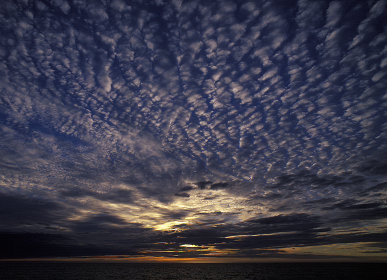
ARCTIC: At the Cutting Edge of Climate Change, #7: When Bill Simon decided to create "Itasca," he purchased a super-tanker tug and remodeled it. He was attracted to the durable construction and motor power, but because he was going to take this boat to both the Arctic and the Antarctic, what he liked most about it was that it had TWO systems for everything. If something broke down, they could remain operational. Further, in planning this attempt to cross through the Northwest Passage, he invited his architect for the boat to come on the trip, AND he also hired two of the craftsman that built it as part of his crew. He could have hardly known how quickly his decision to do so would prove a wise choice. In the quieter waters of the bay around Teller, and with the storm backing off a bit, we assessed our damage while waiting for Bill, his other guests, our supplies, and the attendant truck convoy to arrive. Two big windows had been damaged, several doors were torn off hinges, and a number of wooden cabinets had been smashed or ripped off walls. Everything was superficial AND BEST OF ALL, OUR STAFF WOULD REPAIR EVERYTHING waiting for Bill come, and the weather to clear.
photograph(s) © copyright, ROBERT GLENN KETCHUM, 2016, @RbtGlennKetchum @LittleBearProd #LittleBearProd
Follow Robert Glenn Ketchum's Photographic Activism Online:
WEBSITE: http://www.robertglennketchum.com/
PINTEREST: http://www.pinterest.com/littlebearprod/
SOCIAL MEDIA by #LittleBearProd: http://www.LittleBearProd.com
Wednesday, September 21, 2016

ARCTIC: At the Cutting Edge of Climate Change, #6: By the time we collected my gear and got it to the zodiac in the harbor, the swell outside the breakwater had grown to about ten feet and occasional sets would "close-out" the boat channel. We had to time the zodiac passage in between wave sets, and even so we got a little air going over an incoming wave as we jetted out. Back at Itasca, we had another problem - the swell was causing Itasca to roll SO much that you had to time your jump to the boarding ladder. After several attempts, my gear and I were transferred, and as I was the 1st guest to arrive, I met the crew and settled in. We were being assaulted by the swell AND IT WAS GETTING BIGGER. One more guest arrived about an hour later, they barely could get him onboard, and he was IMMEDIATELY seasick. We were told Simon, the other guests, and a large number of supplies would arrive in the morning. The swell pushed 20-25ft as night drew down. Eating dinner was tricky. Sleeping was a joke as I was often thrown from my bed. Finally, I went to the sitting area on the upper deck to lie on a couch that did not pitch me as much. Dozing off, there was suddenly a tremendous crash. The glass windows across the room shattered, water came through and furniture and a big TV were hurled around. We just got slammed by a huge wave, we have considerable damage, and we are now pulling anchor to motor farther out for the rest of the night. At dawn the weather is still raging, BUT Simon's plane arrives. There is NO getting out to Itasca, so it is decided that we will head north to a protected shallow bay and the tiny town of Teller (about 230 people). To move his guests and the supplies, Simon makes deals with Nome locals who have trucks, to drive his entourage the 90-miles or so of rugged road to Teller, where calmer waters will allow them to board. This is Teller from our anchorage later that day, AND, THIS IS JUST THE 1st DAY OF THE TRIP.
photograph(s) © copyright, ROBERT GLENN KETCHUM, 2016, @RbtGlennKetchum @LittleBearProd #LittleBearProd
Follow Robert Glenn Ketchum's Photographic Activism Online:
WEBSITE: http://www.robertglennketchum.com/
PINTEREST: http://www.pinterest.com/littlebearprod/
SOCIAL MEDIA by #LittleBearProd: http://www.LittleBearProd.com
Wednesday, September 14, 2016

ARCTIC: At the Cutting Edge of Climate Change, #5: When the rolling tundra reaches the coast it just plunges off to the shoreline. The city of Nome is a VERY tiny community surrounded by this, but it does have a pier, and an inlet protected by a breakwater that offers a small boat harbor. I flew in during the early morning through some really bad weather that actually threatened to cancel the flight. On the ground I was to report to the harbormaster who would connect me with "Itasca." From his office window I could see a big cruise ship anchored at the pier. Offshore there was also another large boat anchored in deep water. That was Itasca. There was no room for her to dock at the pier, and she was too big to bring into the harbor, so she had been positioned well outside of the considerable swell that was slamming into the harbor breakwall. The harbormaster told me he would radio the boat, they would launch a zodiac to come and get me, AND I should "go get a drink" as he felt I would need it for the ride back out. Doing as I was told, I headed for one of the MANY bars along main street. I also had the good sense to apply "the patch" for seasickness so it would be in effect when needed (and it would be needed.) About an hour later I was joined at the bar by four men in matching gear and they were ALL wearing Mustang boots. I knew my hosts had arrived. Now for a short boat ride!
photograph(s) © copyright, ROBERT GLENN KETCHUM, 2016, @RbtGlennKetchum @LittleBearProd #LittleBearProd
Follow Robert Glenn Ketchum's Photographic Activism Online:
WEBSITE: http://www.robertglennketchum.com/
PINTEREST: http://www.pinterest.com/littlebearprod/
SOCIAL MEDIA by #LittleBearProd: http://www.LittleBearProd.com
Wednesday, September 7, 2016
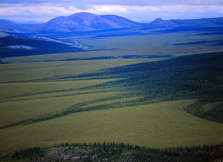
ARCTIC: At the Cutting Edge of Climate Change, #4: After my lunch with Bill Simon and Secretary George Schultz, I was left with simple instructions: come COMPLETELY prepared; bring cameras, including motion as well as still; the trip might be long so bring lots of film; get Mustang knee-high rain boots with WHITE soles (to protect the boat deck); and, show up in Nome, Alaska, at a particular date and time where I would meet and board, "Itasca," the boat that Bill had custom built for this adventure. I had no trouble collecting appropriate gear as I had been spending a good deal of time in Alaska, but still I was a bit intimidated because I had never gone THIS FAR north, and I was unsure that we would even succeed in crossing the Northwest Passage in a single season as no private boat yet had. Nome iwithin 150 miles of the Arctic Circle and surrounded by tundra and rolling hills facing DIRECTLY into the Bering Sea. If you have never seen the vast sprawl of the Arctic landscape in Alaska, it can be quite intimidating. It is spare of vegetation, and distances are quite deceiving and hard to grasp, partially because of the clear air. In this image you actually see the rolling curves of the earth, and in the top left, the small, light ribbon of pale color is the VERY LARGE Noatak river, almost invisible from this perspective.
photograph(s) © copyright, ROBERT GLENN KETCHUM, 2016, @RbtGlennKetchum @LittleBearProd #LittleBearProd
Follow Robert Glenn Ketchum's Photographic Activism Online:
WEBSITE: http://www.robertglennketchum.com/
PINTEREST: http://www.pinterest.com/littlebearprod/
SOCIAL MEDIA by #LittleBearProd: http://www.LittleBearProd.com
Wednesday, August 31, 2016

ARCTIC: At the Cutting Edge of Climate Change, #3: Allow me to introduce Our Fearless Leader - former Secretary of the Treasury under 3 different presidents, William E. Simon. He is NOT as "crazy" as this picture makes him appear, but he does wear very thick glasses and when you are talking to him and looking straight at him, it magnifies his eyes AND it always made me feel he was studying a person "under-the-microscope." That was especially true of our first meeting. Bill did invite me aboard his Arctic expedition, but with a caveat. As we had not met and the boat trip might take several months, he wanted to meet me in person over a meal to see if I would "fit-in" with he and his other guests. He said he was flying to San Francisco for the annual party of the Bohemian Club at the Bohemian Grove and he would fly me up from LA prior to that event so we could have lunch. I was given an address on the Stanford Campus and when I pulled up at the building, I realized it was the Hoover Institute. Considered a conservative policy think tank, I knew my poney-tail and mustache would be noted, and no sooner had I stepped through the doors than the receptionist looked up and said, "Oh, you must be Mr. Ketchum." I was directed to an office upstairs and when I arrived at that door, there was yet another amusing thing to note - it was the office of George Shultz, former Secretary of Labor, then Treasury, and finally US Secretary of State. Inside Bill and George were waiting for me, most gracious and engaging. Sack lunch sandwiches were served. We talked, and after about 45-minutes, Bill and George indicated they needed to be on their way, and I should stay and finish my meal. Oh yes, I was indeed invited aboard! And so, WE are off to the Arctic! Will you join me?
photograph(s) © copyright, ROBERT GLENN KETCHUM, 2016, @RbtGlennKetchum @LittleBearProd #LittleBearProd
Follow Robert Glenn Ketchum's Photographic Activism Online:
WEBSITE: http://www.robertglennketchum.com/
PINTEREST: http://www.pinterest.com/littlebearprod/
SOCIAL MEDIA by #LittleBearProd: http://www.LittleBearProd.com
Wednesday, August 24, 2016

ARCTIC: At the Cutting Edge of Climate Change, #2: The unusual telephone call came out of the blue, and after stating his name the caller launched into this tale of his intentions to cross the Northwest Passage on a luxury research vessel that he had specifically designed for the adventure. I was unsure why I was being called but thought he was proposing a "cost-sharing" expedition he wanted me to join, or perhaps teach a workshop onboard. When I queried what he wanted from me, he responded, "Oh, I am sorry! I realize my call is unexpected. Your name was given me by a mutual friend and I am William Simon, former Secretary of the Treasury. I have built this boat for this expedition and I am inviting some friends and scientists. It was suggested we should have a filmmaker or photographer as well, and 3 of my guests knew of your work. If you are interested in being photographer to this expedition, you would be my guest. There are no expenses for you. I will cover everything. " WHAT!!!! I did say YES, and there is more to that story in future posts, but for the moment allow me to introduce the 2nd author to enrich my encounters with the Arctic, John Bockstoce. John was one of Bill Simon's guests. At the moment of this picture, we have been stuck in ice for a few days and have gotten stir-crazy, consequently after lunch libations, John has led us on a "hike" across the ice. Several boat staff members also rode a snowboard while holding on to a rope that another ran ahead pulling. Note the mud of John's knees - he has been groveling (how do you get muddy on an ice-flow?) I think you can conjecture where this group is going with John leading the way. I hope you will join me on this VERY AMUSING journey.
photograph(s) © copyright, ROBERT GLENN KETCHUM, 2016, @RbtGlennKetchum @LittleBearProd #LittleBearProd
Follow Robert Glenn Ketchum's Photographic Activism Online:
WEBSITE: http://www.robertglennketchum.com/
PINTEREST: http://www.pinterest.com/littlebearprod/
SOCIAL MEDIA by #LittleBearProd: http://www.LittleBearProd.com
Wednesday, August 17, 2016

ARCTIC: At the Cutting Edge of Climate Change, #1: I hope you will find this new blog as surprising as I found the Arctic to be. In looking back, I realize I knew nothing about the Arctic and presumed, incorrectly, that it was similar to the Antarctic, I mean they were both frozen poles, right? I could not have been more wrong! I did have an interest in the Arctic because I believed in the possibility of climate change, and I knew the Arctic influenced the weather of the Northern Hemisphere, so I wondered what effects might be felt at the pole, but what truly turned my attention to the "great white north" was an award-winning book, by my colleague, Barry Lopez. His 1986 book, "Arctic Dreams," came to my attention in the early 90's, and I was literally blown away after reading it. So much so, in fact, I contacted Barry to see if he could get me an invitation to one of the few research/housing compounds that would give me some access and from where I could begin to make pictures. He was willing to help but before his contacts responded, I received a most unusual phone call, one that would eventually give me a stunning base from which to view the vastness of THE ARCTIC.
photograph(s) © copyright, ROBERT GLENN KETCHUM, 2016, @RbtGlennKetchum @LittleBearProd #LittleBearProd
Follow Robert Glenn Ketchum's Photographic Activism Online:
WEBSITE: http://www.robertglennketchum.com/
PINTEREST: http://www.pinterest.com/littlebearprod/
SOCIAL MEDIA by #LittleBearProd: http://www.LittleBearProd.com
____________________________________________________
| Social Media by @LittleBearProd |
