

NO PEBBLE MINE Pictures from Ground Zero
by Robert Glenn Ketchum

Since 1998, I have been working to protect the spectacular resources of southwest Alaska and the fishery of Bristol Bay. Two Aperture books, a national traveling exhibition, a massive coalition of concerned users, and a lot of personal lobbying, had it looking like we were almost there. Then Donald Trump took office claiming he would always put America, and American jobs first. SO WHY destroy a BILLION-dollar-a-year, RENEWABLE salmon fishery and over 100,000 jobs for a group of international mineral speculators that will leave us with a Superfund site to clean up, and NO fishery left edible? And yet, he did,..so please, keep saying NO TO THE PEBBLE MINE!
~Robert Glenn Ketchum

NO PEBBLE MINE #338, Pictures from Ground Zero
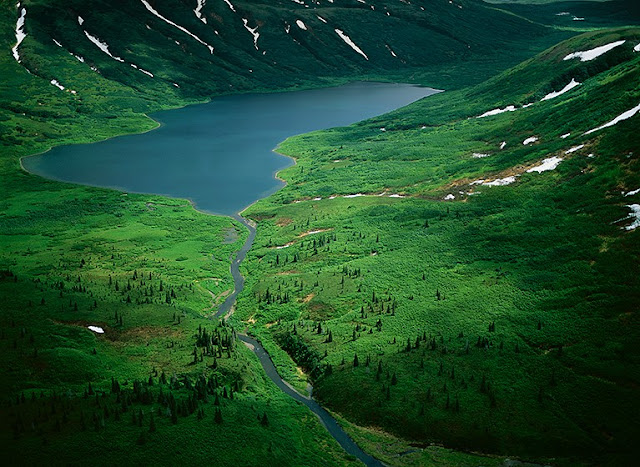
NO PEBBLE MINE #338: Because we are in a boat with a shallow draft and a lot of power, we continue to push up into the headwaters of the Goodnews River, even through some sketchy shallows, and rapids. My two hosts, enforcement officers from the ADF&G, patrol this river daily though, so they know exactly what we are doing, and I am just along for the ride and the view. We are now at a point where the embankments have flattened out, and the tundra rolls off in every direction around us. The Goodnews is also shallow, narrow, and meandering enough to make it impossible for a plane to land, so we are beyond the realm of floaters, fishing and camping. There is no one else out here but us,..and a lot of animals. Because the terrain is navigable, they want me to take a hike onshore they think will prove interesting. Of course, they tag along as my bodyguards, both sporting holstered pistols, and rifles over their shoulders. The consensus here is that the views are expansive enough that we will see whatever animals (bear) might be out there, before they become of danger to us. We do see several moose, we hear wolves, and then over one of the rolls in the landscape, this nicely constructed beaver pond and lodge complex appears, replete with busy beavers, another moose, and several eagles. In a light, on-and-off rain, we snack here while watching the activity, and then work our way back to the boat.
PINTEREST: pinterest.com/LittleBearProd/
_____________________________________________________
Tuesday, February 26, 2019

NO PEBBLE MINE #337, Pictures from Ground Zero
NO PEBBLE MINE #337: The spectacular sunset of the previous night (last two posts) ushers in weather from the Pacific, so we awake to a blustery, cold, and rainy morning. It is nice to be able to have a casual breakfast in the warmth of the cabin in which my two hosts reside while doing their summer enforcement patrols on the Goodnews River for the Alaska Department of Fish & Game. Back out in the boat and on the river, it is another story, and we all fleece-up and put on raingear. Their camp is situated in the last really broad section of the river, and as we move upriver, closer to headwaters, the river narrows, and the banks steepen and grow taller. We do not see many floaters on the river this morning, probably because of the lousy weather, but we do find many still in camp. We are now deeply into Native land, upon which there is no trespass to camp or fish. Nonetheless, we make several stops to inform groups that they need to remove their encampments from the shore, and find a sandbar where they can camp legally. Curious about how enforcement plays out, I ask if the penalty of being fined accomplishes anything, AND what about the houseboat guy we encountered yesterday? They tell me they reported him last night on the radio in the cabin, and Native enforcement officers will deal with him, arresting him for trespass, seizing his illegal fish catch and fish-wheel, and, likely, breaking down his boat. My hosts assure me working it this way will be far more effective, then if they took action. They also point out that many floaters who are fishing, are with local guides, and the guide can loose their license if the floaters break the law.
PINTEREST: pinterest.com/LittleBearProd/
_____________________________________________________
Tuesday, February 19, 2019

NO PEBBLE MINE #336, Pictures from Ground Zero
NO PEBBLE MINE #336: I am sure the two Alaska Department of Fish & Game officers, in whose cabin I am having dinner, think I am a little nuts, because I keep leaving our meal to go back outside. As you see in the last post, there is quite a show going on, and this is SUMMER in Alaska, so the show goes on for a LONG time. The sun doesn’t set until 10pm or so. Although the wind does not pick up, the temperature drops dramatically as night falls, causing patches of ground fog to appear, disappear, and re-appear. I assure my hosts that my behavior comes with my job, and it is likely getting great results. I also thank them for hosting me in their very trick camp. The cabin is very cozy, but is too tight to sleep three, so I have my tent and there is a nice soft-sand floor quite close to the cabin where I pitch. As the cabin is relatively bear-proof, they want me to divest my tent of EVERYTHING, so there are no scent traces that might attract a bear,..except for mine. Then, they hand me a shotgun with hand-loaded slug shells, and suggest I keep it next to me “in case.” They do say, however, they have never had a bear visit this bar when they have been here, and frankly, it is Southwest, there are bears everywhere I go. I can’t say that I am used to them, but I have learned to sleep soundly.
PINTEREST: pinterest.com/LittleBearProd/
_____________________________________________________
Tuesday, February 12, 2019
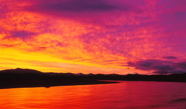
NO PEBBLE MINE #335, Pictures from Ground Zero
NO PEBBLE MINE #335: As the two Alaska Department of Fish & Game enforcement officers and I work our way up the Goodnews River, I go ashore and climb low hills in many places, in spite of the unsettling evidence of grizzlies on the first beach at which we stop. The river remains wide, and in many places there are sizable sandbars around which we carefully navigate. One of these, further upstream, hosts our camp. I am amazed at the number of float groups fishing the river, many of whom do not have necessary permits or fishing license. I find it depressing that there are SO many that want to cheat the system. They have come great distances to fish trophy-class waters, for which, apparently, they have little regard, and they refuse to acknowledge there must be management to prevent overfishing. Our most amazing encounter is a 60-ish, white male, who tells us he was born in state, lives part of the year farther north, and then during salmon season, he comes here to fish for his “winter supplies.” The ADF&G officers know him, so we stop to board the houseboat he has built for himself, which is presently anchored to trees on the riverbank. He has no license. He has no permits. He has an illegal fish wheel trap, which he denies using. He also has WAY MORE fish iced than seems even close to legal. YET, he yells at us, saying because he was born in state, none of the laws apply to him, because he had these rights before the laws existed. The officers have heard it before, and issue him several citations. He is one of our last encounters for the day, and about 1/2 hour further upriver, we come to a section with a massive sandbar in the middle that sports a shed, a cabin, a small dock, and a lot of “Alaskan gear.” We are home. As it is getting dark, my hosts start dinner, and I wander out on to the bar to watch the unfolding of the evening’s stunning sunset. We are looking downriver, and to the west. It HAS been a good day on the Goodnews, and now, real food not freeze-dried.
PINTEREST: pinterest.com/LittleBearProd/
_____________________________________________________
Tuesday, February 5, 2019

NO PEBBLE MINE #334, Pictures from Ground Zero
NO PEBBLE MINE #334: The two river enforcement officers who are helping me explore the Goodnews drainage and headwaters, have told me that I can go ashore anywhere that looks interesting, so there will be more variation to my shoot, than just from the water. After our first few early morning encounters with float fishermen, checking permits, etc., we come to section of the river with deep current along one shore, but a huge sandbar extending from the other side, and some access to a marsh area, formed in the bend of a meander (previous post). We all disembark on the sandbar, but as we do, I note that both of them break out their shotguns. I have an armed guard! Without the wind off the river, the day is sunny and warm. Being ashore offers me a very different take on the terrain, I make many pictures, and push further back from the river, into the marshy meander. Until we arrive here! It is a nice view of what apparently is a VERY popular area. The female officer also has a biology degree and identifies 9 different species of bird tracks (foreground, middle & right) in the sand. However, there are also some MUCH larger prints, going out of the frame to the left - it is a VERY big grizzly bear, and it has just walked through recently because some of the tracks still hold water. Stopping for this shot makes both my hosts nervous, so they are grateful I do it quickly, and we beat a quiet retreat to the boat. Perhaps it is time to move to another location.
PINTEREST: pinterest.com/LittleBearProd/
_____________________________________________________
Tuesday, January 29, 2019

NO PEBBLE MINE #333, Pictures from Ground Zero
NO PEBBLE MINE #333: The Goodnews is a big, long river that has a considerable volume at its mouth, hence the ADF&G enforcement officers that are helping me explore the drainage, work with a powerful boat that has considerable thrust to forge upstream travel. It also has a fully enclosed cabin to keep us out of the wind, and because the weather is often so horrible. The officers have a job mission to fulfill, which they do EVERY DAY, working from a cabin camp about mid-river. They patrol up and down the river length, checking the endless stream of fishermen that fly in from all over the world to fish southwest Alaska. Some of those obey the laws, have the appropriate permits, and respect the catch limitations, others don’t. Certain ones believe because they are “Alaskan,” they can fish where and when they choose without limits. EVERYONE is armed. It makes my trips with them interesting. Another uniquely Alaskan issue here is Native land trespass, which my associates also enforce. Most fish the Goodnews on 10-day float trips, being dropped by air below the headwaters, and then camping while drifting to Goodnews village to be flown out. However most land on either bank is Native owned, and there is NO trespass. The floaters MUST camp only on river sandbars, which are not always where they might want to be. Many times they also disembark on select river banks to fish prime spots, which is not allowed either. We stop them, explain the rules, and issue expensive tickets. Some people are told to immediately leave the river. Some guide groups are also fined for allowing their guests to abuse the rules. It is an interesting process to watch. When not doing any of that, these officers offer to take me anywhere I might like, and they will stop so I can shoot from the land, whenever that might help.
PINTEREST: pinterest.com/LittleBearProd/
_____________________________________________________
Tuesday, January 22, 2019

NO PEBBLE MINE #332, Pictures from Ground Zero
NO PEBBLE MINE #332: I am in the small Native village of Goodnews, awaiting two river enforcement officers from the Alaska Department of Fish and Game to pick me up in their patrol boat, and take me to explore the Goodnews river drainage and headwater. This is the first time I have worked with ADF&G, so I have no idea what to expect, so at the moment, I sit by the small river dock with my gear, waiting, only to be occasionally cruised by teenagers from the village riding 4-wheelers. It is a beautiful, warm day and quite peaceful by the river, so it is very clear when the officers arrive, because I can hear the noise of their engine. There are, indeed, two officers, armed with serious, holstered handguns and wearing badges. One is female. We exchange greetings, they grab my gear, and we are off. With such a great day, I go to work immediately and start shooting, while in-between, we discuss what I am hoping to do with this project. At the start of the trip, basically the delta of the Goodnews, the land is very flat and brushy. There is a downstream wind building that makes the leaves ashore shimmer as it gusts through their branches. It seems to be a good day in Goodnews!
PINTEREST: pinterest.com/LittleBearProd/
_____________________________________________________
Tuesday, January 15, 2019

NO PEBBLE MINE #331, Pictures from Ground Zero
NO PEBBLE MINE #331: Delivered to Goodnews by a plane from Dillingham, I await an upriver boat pick-up from colleagues in the Department of Fish and Game. While waiting, I am surveying this small Native village, and considering what it must be like to live here throughout the year - at the edge of the Arctic Circle, on a gravel-scrub-tundra shoreline, facing into the north Pacific, and without much supportive infrastructure to speak of - this is a rugged lifestyle! Of course, everyone fishes. Freshwater fish and spawning salmon are in the Goodnews river, and Goodnews Bay opens into one of the most productive marine fisheries in the world. No one in this village, however, is a “commercial” fisherman. There are no industrial fishing boats here. This is the fishing “fleet” for the village. It is a flotilla of Lund’s! In one of these, a skilled hunter might catch fish, or marine mammals, hunt seals, and raid cliffside bird rookeries for their eggs. It takes a distinct skill set, and some considerable confidence to go out hunting by yourself, in one of these.
PINTEREST: pinterest.com/LittleBearProd/
_____________________________________________________
Tuesday, January 8, 2019

NO PEBBLE MINE #330, Pictures from Ground Zero
NO PEBBLE MINE #330: The Native village of Goodnews sits at the confluence of the Goodnews river, and the ocean, in a large bay that faces directly into the northern end of Bristol Bay and the north Pacific. There is a boat access area at the river, and a dirt airstrip that parallels the river, both set slightly off from the town. No streets are paved, and everyone rides 4-wheelers. There are no cars. There is a small store, and a laundry, but there are no restaurants, and there are no hotels. I am told if I have to overnight here because of weather, the best place to sleep is the floor of the laundry. From my current vantage, the surrounding refuge seems comprised of rolling hills, but as I travel upriver, I will discover it much more mountainous closer to the headwaters. At the moment, however, I have been delivered here with a load of gear and food, and I am awaiting rangers from the Department of Fish and Game to pick me up in their boat. They travel this river regularly because it is a world class fishing destination, and they check permits, catch numbers, and violations of trespass on Native land. I am going to hang with them for a few days and explore the watershed.
PINTEREST: pinterest.com/LittleBearProd/
_____________________________________________________
Tuesday, January 1, 2019

NO PEBBLE MINE #329, Pictures from Ground Zero
NO PEBBLE MINE #329: In the last post, I mention the wild beauty of the miles and miles of coastline in the Togiak National Wildlife Refuge, which we will eventually fly above, but now, I am going to put us on the ground to float a few principal rivers. Above is the tidal estuary of a river that I do NOT float, the Kulukak, but it is certainly a luxuriant landscape. I advise you once again to be sure and follow the link, AND to use the + - to get ASTOUNDING detail at high magnification. This river system, like the Snake river I posted last week, is a stunning abstraction from the aerial perspective, and these maps are such remarkable tools. If you do go to the map in the link, zoom way out and follow the coastline north (to the left). After a substantial bit of rugged shoreline, you will see Togiak (a Native village), then another, Platinum, followed by Goodnews Bay, and the small Native village of Goodnews. This will be where I begin an upriver trip to explore the Goodnews river system.
PINTEREST: pinterest.com/LittleBearProd/
_____________________________________________________
Tuesday, December 25, 2018

NO PEBBLE MINE #328, Pictures from Ground Zero
NO PEBBLE MINE #328: At the southern, eastern boundaries of the Togiak National Wildlife Refuge, the mountains subside and tundra plains slope down to the shore of the Nushagak River and Bristol Bay. This does not mean fewer rivers than elsewhere in the refuge, it just means the rivers here have more room to meander. This is the Snake. Muddy, slow-moving, often looping back upon itself, it is an amazing graphic to be seen from above. I hope you will take advantage of the Google map links I provide. In the VERY hi-def satellite view, the Google maps reveal some beautiful abstractions of these rivers and their deltas. Be sure to use the + - features to enlarge some these very visual, natural systems. I am sure you have noticed the profusion of small lakes as well. Wait until our travels take us out along the coast. Those pictures are coming soon, and they reveal a spectacular, and lake-lined coast, with big estuaries, and miles-long beaches (where at one point I saw two grizzly bears feeding on a dead whale that washed up on the beach).
PINTEREST: pinterest.com/LittleBearProd/
_____________________________________________________
Tuesday, December 18, 2018

NO PEBBLE MINE #327, Pictures from Ground Zero
NO PEBBLE MINE #327: I fly over the Togiak National Wildlife Refuge many, many times in four years of work. Sometimes it is a flight-see, other times are en route to river floats, or visits to villages. I fly with numerous pilots, all of them local. Above the refuge, they all know the names of the largest rivers, but few can even come close to naming the myriad of smaller ones..and we are not talking streams, these are rivers. I did ask if anyone does know all the names, and was assured that each of the villages, and there are many in the refuge, knows the specific river names around them very well, and their hunters may know more because they travel farther. Nonetheless, the consensus is, no one knows them all except the mapmakers. This is a landscape that hosts the greatest freshwater diversity in North America, funneling all this down into Bristol Bay, and creating the most productive salmon fishery in the history of the world. NO PEBBLE MINE! This is a world of fish.
PINTEREST: pinterest.com/LittleBearProd/
_____________________________________________________
Tuesday, December 11, 2018

NO PEBBLE MINE #326, Pictures from Ground Zero
NO PEBBLE MINE #326: Over 4-MILLION acres in size, the backcountry of the Togiak National Wildlife Refuge is an endless expanse of mountains and valleys, rivers, lakes, and wetlands. Rivers are EVERYWHERE! Rivers that appear sizable beneath the wing, flow into bigger rivers that are more impressive,..and then the “big” river flows into one that is even larger. So much flowing water. Even the large rivers are numerous. The Kanektok, Goodnews, Kanik, Kulukak, Negukthlik, Togiak, Kinegnak, and Snake (there is always a Snake) are so large they have huge tidal deltas and complexes of wetlands where they meet the coast. They exist, however, because THOUSANDS of streams and tributaries feed their headwaters.
PINTEREST: pinterest.com/LittleBearProd/
_____________________________________________________
Tuesday, December 4, 2018

NO PEBBLE MINE #325, Pictures from Ground Zero
NO PEBBLE MINE #325: I do overflights of the Togiak National Wildlife Refuge numerous times and in very different seasons. I also float most of the major rivers. This imaginary flight will now bleed those experiences together in this blog. The last two posts feature one of my most dramatic morning arrivals in the refuge, resplendent in brilliant fall colors. Here is the other extreme. This is early spring. It rains almost everyday. The landscape is an amazing shade of emerald green, and the insect population is off-the-chart. It is good to be airborne. The Togiak refuge is home to a number of Native villages, some of which I will use as staging areas for my river floats. Those villages, and all the floating occurs on large rivers, but the backcountry is just a labyrinth of smaller streams and valleys wending their way through various ranges. This is big country, and fish, bugs, and much larger animals are everywhere.
PINTEREST: pinterest.com/LittleBearProd/
_____________________________________________________
Tuesday, November 27, 2018

NO PEBBLE MINE #324, Pictures from Ground Zero
NO PEBBLE MINE #324: Our flight into the headwaters of the upper Togiak River afford of spectacular view of the plain of the Togiak National Wildlife Refuge (last post), but the river is still too small for our plane to land upon, so we turn west, following the Togiak downstream toward the Pacific. This view is now west, and all of that is the refuge, as well, including the mountains. My work around Bristol Bay has opened a world of new places to me that I can only define with superlatives. Wood-Tikchik State Park, at 1.6million acres, is the largest state park in the US. Togiak is THREE TIMES LARGER than Tikchik, encompassing nearly 4,300,000 acres. That is a lot of room for the buffalo to roam,..or in this case the moose, bear, caribou, and wolves. Lest we not forget the resplendent fishery. Our flight west follows the Togiak until it grows larger and broadens. Above you can see a river fed valley full of fall trees, feeding into the Togiak, swelling it evermore in size. Not much farther ahead, our flight sets down on the river, and the rest of the day is spent successfully fishing. On the eve, we return to Tikchik Narrows Lodge to eat our catch. In my next post, our imaginary flight above Togiak continues over its far reaches, so if you enjoy the view of still wild, untrammeled places, stay tuned.
PINTEREST: pinterest.com/LittleBearProd/
_____________________________________________________
Tuesday, November 20, 2018

NO PEBBLE MINE #323, Pictures from Ground Zero
NO PEBBLE MINE #323: Over several years, I have many flights over the Togiak National Wildlife Refuge, so I am witness to the seasonal changes. Perhaps the most spectacular of these moments, occurs following the path of our present, imaginary flight. I am with fishing guests from Tikchik Narrows Lodge, and we have flown over the Wood Mountains, out of Wood-Tikchik State Park, and into Togiak, to fly fish on the upper Togiak River. All such fishing adventures begin early in the day from the lodge, and the morning sun is just awakening the plains of the refuge, when we arrive. It is a stunningly clear day, and not only does it make the light brilliant and the fall colors glow, it gives all of us a great sense of how large the refuge is. Everything you see here is part of it, including all of those mountains... and this view is north. There is much more west, to the coast. Above, you can also see a stream (coming from the left) joining the headwaters of the upper Togiak River.
PINTEREST: pinterest.com/LittleBearProd/
_____________________________________________________
Tuesday, November 13, 2018

NO PEBBLE MINE #322, Pictures from Ground Zero
NO PEBBLE MINE #322: As we fly into the Togiak National Wildlife Refuge, the terrain and habitat change in a noticeable way. For one, the refuge is more expansive than Wood-Tikchik State Park, where we have just been. It is easily two or three times larger, and that difference is visible immediately from the area. The valley we are following “down” from the mountains, broadens as it gets lower, finally spilling onto the basin floor that forms the refuge. Below our wings, several streams merge, and I can see others pouring in from elsewhere. Then, a number of lakes appear, into which these drainages are feeding. The pilot tells me that we are in the headwaters of the Togiak River, which we will now follow to the coast, and these are part of the Upper Togiak Lake(s). This parting view shows the headwater lakes, and looks south and west, back into the distant peaks which are part of Tikchik.
PINTEREST: pinterest.com/LittleBearProd/
_____________________________________________________
Tuesday, November 6, 2018

NO PEBBLE MINE #321, Pictures from Ground Zero
NO PEBBLE MINE #321: Similar, but not the same, the landscape beneath our wings suggests the familiar high valleys of Wood-Tikchik State Park, and yet the terrain here seems more expansive and less vertical. The summits are not as rocky, and the bush is more tundra than dense thrash. There is still A LOT of water everywhere, and every valley supports a river system, all of them descending into the Togiak National Wildlife Refuge and ultimately, flowing into the fishery of Bristol Bay. I would never refer to Wood-Tikchik as small, at 1.6-million acres, it is the largest state park in Alaska, and arguably, also in all of North America, BUT as we leave the mountains and enter the refuge, I immediately sense a MUCH LARGER ecosystem at the foot of these new and different mountains, and across this basin to the sea.
PINTEREST: pinterest.com/LittleBearProd/
_____________________________________________________
Tuesday, October 30, 2018

NO PEBBLE MINE #320, Pictures from Ground Zero
NO PEBBLE MINE #320: Squalling weather rolls over my pilot and I while we are on the ground at Heart Lake, and after it passes, we agree that we should return to our specific purpose of passing over the Wood River Range and into the Togiak National Wildlife Refuge. As quickly as the rain came, it is gone, and the wind dies down, too, so we are off. As I look out over this terrain, I do not yet realize how alpine, and VERY different it is, from other landscapes I have flown above, but that will now change quickly. We are headed north and west, leaving the Wood mountains behind, and soon to see a similar, but not the same, rugged, wild terrain that forms the refuge. Togiak is headwaters to numerous rivers that feed into the Bristol Bay fishery, and we will now explore them from above. I float most of them as well. Stay tuned!
PINTEREST: pinterest.com/LittleBearProd/
_____________________________________________________
Tuesday, October 23, 2018

NO PEBBLE MINE #319, Pictures from Ground Zero
NO PEBBLE MINE #319: Camera and tripod in hand, I wander around the shoreline of Heart Lake for a distance, mostly caught up in the rain saturated fall colors of the tundra, in contrast to the pale blue color of the water. Sometimes you just work too hard to see what you expect, and you fail to see “the surprise.” There always is one. This is mine for the day (above). Eventually the weather begins shifting back into rain, so I begin a return to the plane. In so doing, I surmount a small rise of tundra, and am presented with this POV. I am sorry my blog has no sound, because at this moment, the wind is, literally, howling around those summits, and the clouds are being torn into tatters. Camping up here would be a VERY interesting experience. For now, however, it is about to storm on us, and my pilot and I are on our way into the Togiak National Wildlife Refuge. We have just been sidetracked up here for awhile... then this happened!
PINTEREST: pinterest.com/LittleBearProd/
_____________________________________________________
Tuesday, October 16, 2018

NO PEBBLE MINE #318, Pictures from Ground Zero
NO PEBBLE MINE #318: As we follow the meandering valley beneath our wing, the water in the river becomes increasingly pale blue in color, indicating it contains little soil and is almost entirely glacial meltwater. We are also not far above the ground, but we ARE high in altitude. The dense bush gives way to tundra and exposed granite,..and what the pilot says is Heart Lake, appears. It is jewel-like,..a pale sapphire blue, nestled into a colorfully dappled, tundra-lichen bowl, surrounded on three sides by impressive summits. It is easily large enough for a landing and so we do. Disembarking to shore is simple, and coincides nicely with a break in the weather, When the sun comes out, it causes the rain-droplet-covered tundra to sparkle. There is lichen everywhere, and in every color and shape imaginable. This is clearly an attractive place to feed if you are a caribou (they eat mostly lichen), and with the dense Alaskan bush at bay, hunters can move around a greater range of the landscape, so I understand why he brings his hunting campers here. Today, I am armed, and shooting,..but not at caribou.
PINTEREST: pinterest.com/LittleBearProd/
_____________________________________________________
Tuesday, October 9, 2018
NO PEBBLE MINE #317, Pictures from Ground Zero
NO PEBBLE MINE #317: Wending our way through high mountain valleys between Wood-Tikchik State Park and the Togiak National Wildlife Refuge, our flight encounters spats of nasty weather, which then give way to spotty sunlight, before encountering another round of rain squalls. It is not risky flying because visibility is good, and it IS beautiful, as the landscape beneath the wings, sparkles and glows in lush, vibrant, VERY wet, saturated color. Smaller, more shallow lakes are now starting to give way to larger bodies of water, and this is the first one we flyover that is large enough to land upon. My pilot says we will continue to another that offers “access,” so that I can walk around a bit. He thinks this lake is surrounded by such dense bush, just getting ashore will be difficult.
PINTEREST: pinterest.com/LittleBearProd/
_____________________________________________________
Tuesday, October 2, 2018

NO PEBBLE MINE #316, Pictures from Ground Zero
NO PEBBLE MINE #316: As we depart the huge rolling, tundra-covered hills, and approach a more mountainous terrain, the weather intensifies and there is a good deal of rain in passing squalls. The landscape is becoming evermore alpine, and trees have all but disappeared. The expansive tundra looks like green velvet in the haze of rain curtains. Larger lakes than we have previously seen, appear, but none of them are big enough for us to land. Nonetheless, I know this pilot has been here before, so we are not flying “blind.” He does have an intended destination where he expects to put me on the ground. This past hour has been one of the most remarkable journeys I have ever made. Aside from A LOT of animals, especially caribou and bear, there is nothing in this alpine world but undisturbed wildness/wilderness. I would gladly come back here to camp at some point, but that is not happening this day. However, I am about to find a great campsite where I can get out and “stretch my legs.” More likely, I am going to take my cameras and run around like a wildman, trying to drink in this amazing place from ground level.
PINTEREST: pinterest.com/LittleBearProd/
_____________________________________________________
Tuesday, September 25, 2018

NO PEBBLE MINE #315, Pictures from Ground Zero
NO PEBBLE MINE #315: As we fly toward what my pilot promises will be a lake large enough to land upon, we follow this river valley for a good distance. I am VERY SURE this is one of the most extraordinary and beautiful places I have ever seen, and certainly one of the wildest and most untouched. This is BIG water! Those are large, deciduous trees growing up the embankment in the immediate foreground. My pilot says he knows there is great fishing down there, but no one is crazy enough to try and get to it. As you can see by following the direction of this river, it is really a gorge that runs for a couple of miles, and then it merges into a much broader river valley. Our flight will follow the gorge to that valley, and then we will bear to the right, following the broader valley out of the rolling hills and into a part of this terrain that is more mountainous. That is where he says we will find a lake large enough that we can land.
PINTEREST: pinterest.com/LittleBearProd/
_____________________________________________________
Tuesday, September 18, 2018

NO PEBBLE MINE #314, Pictures from Ground Zero
NO PEBBLE MINE #314: My pilot tells me that he occasionally brings hunters up into this world of huge, tundra-covered rolling hills, and lush river valleys, but he notes that there are only a few points of access for them, and most of the terrain is SO untracked and rugged, that it limits their ability to move about. Obviously, there are no landing strips up here, so we are headed for a lake to land upon, so that I can get out on the ground and have a look around. I do see some small lakes, and occasionally clusters of tundra ponds, but nothing in my field of view is big enough to host a landing. A pilot needs a lake of a certain size to accommodate both a landing AND a take-off, and since we have entered this domain, I have not seen a big enough body of water for us to put down. Nonetheless, he assures me we are headed towards one, so we fly on, slowly approaching some very pronounced summits.
PINTEREST: pinterest.com/LittleBearProd/
_____________________________________________________
Tuesday, September 11, 2018

NO PEBBLE MINE #313, Pictures from Ground Zero
NO PEBBLE MINE #313: On the day of this flight, you can see that there is a lot of weather rolling through, but the clouds remain high and our flying visibility is good,..sometimes even JUST AMAZING! as a spot of sunlight illuminates one of the verdant valleys in the “lost world” we are now above. As always, scale here is difficult to determine until you are down on the ground, but that is a BIG river and a valley that looks like a set designed for “Game Of Thrones.” As we round the corner of the shadowed foothills to the right, we find a small herd of caribou (15) grazing in the tundra below, and a little further down this valley, two bear are playing in the river. I am excited that we might land, as I would like to see if you can walk around in this terrain, and I DO want to have a ground-level sense of this place.
PINTEREST: pinterest.com/LittleBearProd/
_____________________________________________________
Tuesday, September 4, 2018

NO PEBBLE MINE #312, Pictures from Ground Zero
NO PEBBLE MINE #312: As we fly on over this new (to me), high elevation terrain of tundra and rolling domes that marks our departure from Wood-Tikchik State Park, and our entrance into Togiak National Wildlife Refuge, I am surprised by this area my pilot refers to as a “lost world.” It is very different from the ruggedness of the Wood Mountains. He says on rare occasions he brings hunters into these high plateaus to pursue moose and caribou, but mostly, this place is just VERY wild. When I ask about landing, he says we will soon see some lakes, and we will land on one of them to “get out and stretch.” In the meantime, the hills and valleys continue to roll by beneath the wings.
PINTEREST: pinterest.com/LittleBearProd/
_____________________________________________________
Tuesday, August 28, 2018

NO PEBBLE MINE #311, Pictures from Ground Zero
NO PEBBLE MINE #311: As our flight leaves Wood-Tikchik State Park and flies northeast over the Wood Mountains and into Togiak National Wildlife Refuge, I am surprised by the terrain change. The summits of the Wood Mountains are rugged, and in many places still hold snow. To cross over them we have risen through high mountain valleys, often cascading with water. Now, we have entered an entirely different world. With the more ragged peaks fading behind us, we are suddenly over a high elevation terrain of rolling hills, broad valleys, and endless tundra but few trees. The pilot explains that these high valleys are prime moose and caribou hunting, and that so few people come up here, it is like a “lost world."
PINTEREST: pinterest.com/LittleBearProd/
_____________________________________________________
Tuesday, August 21, 2018

NO PEBBLE MINE #310, Pictures from Ground Zero
NO PEBBLE MINE #310: Nearly to the top of the Wood Mountains and out of Wood-Tikchik State Park, into Togiak National Wildlife Refuge, the terrain beneath the wing is in transition. The green thrash and tundra openings are giving way to rock and boulder scree. Caribou can be seen quite often, and bear are wandering high meadows, gorging on berries and carrion from winter-kill. This is a remarkable flight on a good weather day, but on a bad day it can be very unsettling. Winds in these high valleys come abruptly from differing directions, and when I was flying in the small SuperCub back in the park (posts #279-299), those gusts really surprised us and pushed us around. The last post offered some scale by pointing out a herd of caribou on a snowfield, so try this - do you see the waterfall in the lower third of this frame? How big is that?
PINTEREST: pinterest.com/LittleBearProd/
_____________________________________________________
Tuesday, August 14, 2018

NO PEBBLE MINE #309, Pictures from Ground Zero
NO PEBBLE MINE #309: Ascending evermore rapidly now, our “flight” from Wood-Tikchik State Park over the mountains and into the adjacent Togiak National Wildlife Refuge finally reaches true alpine. Summits surround us, and side-valleys plunge back into basins like the one in this image. Although just barely visible in this shot, note the dark dot on the first big snowfield at the bottom of the frame. That is 25-30 caribou, lying down on the snow to escape being bitten incessantly by mosquitoes and bot flies. Amazingly, higher up in the range there are places to land, and pilots bring caribou hunters in regularly, to camp and hunt.
_____________________________________________________
Tuesday, August 7, 2018

NO PEBBLE MINE #308, Pictures from Ground Zero
NO PEBBLE MINE #308: Our “flight” is in the last stages of leaving Wood-Tikchik State Park, and flying over the Wood Mountains, into the Togiak National Wildlife Refuge. The previous posts gave us views of the big lakes, expansive tundra, and broad lower valleys of the park. Now, we are ever-ascending, and although we are not yet alpine, this is a VAST elevated river valley that we are following “up.” That is significant whitewater down there. That river is raging, and surely, snow-melt cold. What a world! I wonder if any kayakers have ever tried to run this?
PINTEREST: pinterest.com/LittleBearProd/
_____________________________________________________
Tuesday, July 31, 2018

NO PEBBLE MINE #307, Pictures from Ground Zero
NO PEBBLE MINE #307: Leaving the lake shorelines, the DENSE bush is virtually unnavigable, but nonetheless, stunning to view. We are heading north and a bit west, crossing over the Wood Mountains in Wood-Tikchik State Park to enter the backcountry of the Togiak National Wildlife Refuge. As we gain elevation in Tikchik, the terrain not only steepens beneath our wing, but it becomes more rugged. There are many animals below, but few people would want to be down there wandering around. Even this late in the summer season, we will still see snow in places, and as with the park, there is water everywhere. Southwest Alaska is the most pristine, American, river-lake habitat left to our nation. Let’s keep it that way and continue to SAY NO TO THE PEBBLE MIINE.
PINTEREST: pinterest.com/LittleBearProd/
_____________________________________________________
Tuesday, July 24, 2018

NO PEBBLE MINE #306, Pictures from Ground Zero
NO PEBBLE MINE #306: As this blog has already explored the backcountry of Wood-Tikchik State Park, some of this transition over the Wood mountains to the Togiak National Wildlife Refuge will seem familiar. Leaving the lakes, our flight follows broad rivers valleys steadily upward into higher elevations. Autumn in Tikchik is an unparalleled display of tundra color that only last about 14-days, so I thought I would leave you with this one last especially luscious shot. What a world! AHH! To be a moose on the loose! Our slow gain in elevation is going to take us from the land of moose, fish, and bear, to a world with caribou and wolves. It is a world of tundra and few trees, but this is the home of alpine lakes, the source collection for much of the water that flows down these valleys.
PINTEREST: pinterest.com/LittleBearProd/
_____________________________________________________
Tuesday, July 17, 2018

NO PEBBLE MINE #305, Pictures from Ground Zero
NO PEBBLE MINE #305: As we leave Wood-Tickchik State Park and cross over into the Togiak National Wildlife Refuge, I am taking one last look around at the remarkable landscape that comprises this habitat of rivers, lakes, and mountains, and provides about 1/3 of the headwaters for the Bristol Bay fishery. Togiak will also have lakes, rivers, and magnificent terrain, but there is nowhere else I feel as radiantly alive as this park. Where the lakes are concerned, the fact many in the park come from glacial melt probably affects there constantly startling coloration, that are like few other bodies of water I have flown above. From here our flight rises a bit to follow a broad river valley, and then we will begin to climb towards alpine. Goodbye Tickchik Narrows Lodge, and once again, thank you very much, Bud Hodson, for allowing me to SEE this remarkable place.
PINTEREST: pinterest.com/LittleBearProd/
_____________________________________________________
Tuesday, July 10, 2018

NO PEBBLE MINE #304, Pictures from Ground Zero
NO PEBBLE MINE #304: As our imaginary flight departs Wood-Tikchik State Park for the Togiak National Wildlife Refuge, I have a few “favorite “ places that I have come to appreciate in this park that we will pass over. As I said in the last post, the sheer verdancy of Tikchik sends off some kind of living-force radiance, and from the air, that always seems especially extravagant around the edges of the big lakes. The best of these lakes host convoluted shorelines that support beaches with quiet bays, and rolling dome terrain, pocketed with numerous small lakes. This is a difficult landscapes to negotiate on foot, because the vegetation is SO dense, AND there both bear and bugs waiting to have a snack suddenly appear,..you! Nonetheless, this is a wild, living, vibrant wilderness that can be enjoyed and observed. Considering what we have done to most of the planet, it might be a good idea to pay some attention to the ecosystem of Southwest, and LEARN from it, instead of imposing ourselves, yet-once-again, on something that we alter and damage, often permanently. Google this history: start in Nova Scotia, go down the entire eastern seaboard, round Florida into the gulf and across Texas, jump to Baja, then go north along the Pacific coast. These used to be American fisheries, some of the world’s MOST PRODUCTIVE, both in food and jobs. They are almost ALL gone now. What is left?
PINTEREST: pinterest.com/LittleBearProd/
_____________________________________________________
Tuesday, July 3, 2018

NO PEBBLE MINE #303, Pictures from Ground Zero
NO PEBBLE MINE #303: Tikchik is more than just the spectacular fall, however, as I have tried to show with the winter images. What I can only hint at in these pictures is something more primal about being in the park. My flights/these images bear witness to creation that is relatively undisturbed and richly evolved. As the glaciers retreat in the higher elevation and the rocks emerge, it is not long before vegetation begins to establish itself. Given the marine influence, the significant rain, warm summers, and long growing hours, life explodes. The tundra establishes. Fish establish and spawn, then die to become super-food for EVERYONE, bears, birds, and TREES! Thickets and cottonwood groves establish along streamsides, other species follow, broadening out across the valley floor. From the backcountry stream headwaters (last post), to the big valley floors with mature rivers, and on to the lakes and plains, what I see in looking back through these images, is magnificent, thriving GROWTH EVERYWHERE. Looking down upon it from a plane while making pictures, I could feel through my eyes, the radiant energy of the world flourishing below, like no other place I have ever visited.
PINTEREST: pinterest.com/LittleBearProd/
_____________________________________________________
Tuesday, June 26, 2018

NO PEBBLE MINE #302, Pictures from Ground Zero
NO PEBBLE MINE #302: As this blog is about to transition from Wood-Tikchik State Park into the Togiak National Wildlife Refuge, and we take our last pass over the terrain of Wood-Tikchik, I spent the last few posts reminding everyone why the Southwest area is so unique, and why those resources should not be threatened by the proposed Pebble mine. Now I would like to thank those that helped me create the images you have seen posted. When I was doing the fieldwork for my first book on the area, Rivers Of Life: Southwest Alaska, The Last Great Salmon Fishery, I overflew Wood-Tikchik many times because it accounts for about 1/3 of the Bristol Bay headwaters, including the significant fishery of the Nushagak river. I had many more good pictures from the park, that did not fit the edit for Rivers Of Life, and I remembered my friend, Jim Stratton, who really raved about the beauty of the park, was now the Director of Alaska State Parks. When I called him to ask his interest in a book about the park, he said that he and his office were in, and he would offer help and contacts. Jim went on to contribute the preface for my book, Wood-Tikchik: Alaska’s Largest State Park' Among the contacts to help me access the park, was Bud Hodson, owner of Tikchik Narrows Lodge, whom I have noted many times in these posts. His willingness to allow me a room at the lodge and window seat in his planes gave me the many pictures I hope you have been enjoying. At 71, I have seen a great deal of the world, and I would say, flying over Wood-Tikchik, right after a rain, at the height of fall, is one of the most beautiful.
PINTEREST: pinterest.com/LittleBearProd/
_____________________________________________________
Tuesday, June 19, 2018

NO PEBBLE MINE #301, Pictures from Ground Zero
NO PEBBLE MINE #301: The thriving, relatively undisturbed habitat of southwest Alaska hosts a collective of hundreds of rivers, and thousands of lakes that feed into the fishery of Bristol Bay. This is not only THE MOST PRODUCTIVE COMMERCIAL WILD SALMON FISHERY IN THE WORLD, it also harvests record challenging cash-crops of herring, and numerous species of crab that can be found nowhere else. The commercial fishery of Bristol Bay is a $1-BILLION-per-year, RENEWABLE RESOURCE industry that employs over 100,000 people, and the largess spreads to many other states, besides Alaska. This commercial catch is the most obvious part of the economy, and the one most used as a reason to SAY NO TO THE PEBBLE MINE. While I don’t disagree about the value of the jobs and the fishery, it is NOT the whole picture. Southwest's stunningly rich freshwaters provide some of the finest recreational fishing anywhere, and wealthy sportsmen from all over the world spend significant time and money to come here. Further, the least developed aspect of Southwest are the parks, which at the moment are accessible, but barely developed for the public in any great numbers. Yet, a recent fiscal analysis of park tourism surprised many, because it discovered Katmai took in twice the money expected, and demand to visit seems to grow with every passing season. I can tell you personally, these parks rival, or ARE GREATER than any parks in the lower-48 I have visited, and when they are finally intelligently developed, they will generate revenue that will match or exceed any of the others. As importantly, many, many Alaskans fulfill the jobs described above, and more might work in Southwest if the parks are properly developed. Again ALL OF THIS is ANNUALLY RENEWABLE industry,..FOREVER if well managed!
PINTEREST: pinterest.com/LittleBearProd/
_____________________________________________________
Tuesday, June 12, 2018

NO PEBBLE MINE #300, Pictures from Ground Zero
NO PEBBLE MINE #300: I am writing a blog about NO PEBBLE MINE, but when I put up pictures like this of Wood-Tikchik State Park, I am trying to point out that this blog’s overall purpose is to “enlighten” those that may be unfamiliar with the ENTIRE area of Southwest, because everything out there is closely interconnected. I want readers to realize what a remarkable and INTACT habitat this is, like few other places on Earth. In this blog, I HAVE posted a picture of the ACTUAL mine site, #30, but that exact location has little to do with the overall impact of the Pebble project that will be more expansive. Returning to this image as an example, Tikchik is a good distance from the mine site, BUT major rivers flowing from Tikchik to the fishery of Bristol Bay, pass below other rivers draining from the proposed mine site. The Pebble Mine is not JUST a pit complex, either. The supportive road system would directly impact Lake Clark National Park, and Lake Iliamna - one of the largest freshwater lakes in the world. I also want readers to understand that other parts of these connected habitats might experience “collateral damage.” Bristol Bay, Katmai, Wood-Tikchik, and Togiak all SHARE pristine air quality, and the rivers they host are some of the most bio-diverse freshwaters in the U.S. To generate power for the Pebble mine, the mine will also dig and burn coal. Burning coal not only contaminates air quality, it puts mercury particles into it, which rain back down into the groundwater system, affecting ALL the lakes and rivers. If you want to argue about the “footprint” of the mine, you need to understand the ENTIRE footprint. You cannot be selective, or A LOT OF JOBS THAT ALREADY EXIST, WILL BE LOST because of the mine!
PINTEREST: pinterest.com/LittleBearProd/
_____________________________________________________
Tuesday, June 5, 2018

NO PEBBLE MINE #299, Pictures from Ground Zero
NO PEBBLE MINE #299: My flight returns to the luxury of Tikchik Narrows Lodge, and the next day I fly back to Anchorage, my winter adventure in Southwest, over. This blog is now going to move further west and north, in another imaginary flight that will take one more glorious overview of Wood-Tikchik State Park, and then we will fly across the Wood Mountains, landing on an amazing high plateau. Eventually, we will emerge above the Togiak National Wildlife Refuge. Togiak is yet another of the spectacular wild lands, like Katmai, Lake Clark, and Wood-Tikchik, that this blog has already featured, and which I believe are among the most beautiful, and currently undisturbed ecosystems in North America. Although I understand some of these locations are NOT exactly at the site of the Pebble mine, ALL of these rivers, lakes, and parklands will be impacted by the development of the mine. This blog has been around A LONG TIME, the NEXT post is #300. I posted an image of the ACTUAL MINE SITE in post #30. SINCE THEN, I have been taking readers on a tour of Southwest, because the riches of Bristol Bay have been created by the pristine quality of the surrounding environment.
PINTEREST: pinterest.com/LittleBearProd/
_____________________________________________________
Tuesday, May 29, 2018

NO PEBBLE MINE #298, Pictures from Ground Zero
NO PEBBLE MINE #298: As we fly over several other gatherings of moose (is there a Moose Lodge out here?), our flight continues down a broadening river valley, that suddenly, looks familiar. The frozen streams beneath us finally show some open water, and ahead I can see the frozen surface of a big lake. In fact, look carefully at the cluster of trees in the left, middle of this image. You can see MY snowmobile tracks from my on-ground adventure of the previous day. It looks like I almost found moose on my ride, but probably best I didn’t (posts #264-278). At the moment, however, my aerial tour of the winter backcountry of Wood-Tikchik State Park is nearly over and the lodge where I have been encamped is just around the corner to the right as the lake flows. I will return to Anchorage tomorrow, but I have certainly fulfilled my promise to my local friends that I would experience southwest in the winter, and make those pictures part of my description-of-place. Once again, thank you Bud Hodson of Tikchik Narrows Lodge for your support in making this happen.
PINTEREST: pinterest.com/LittleBearProd/
_____________________________________________________
Tuesday, May 22, 2018

NO PEBBLE MINE #297, Pictures from Ground Zero
NO PEBBLE MINE #297: With so many trees now about us, my pilot/guide senses a winter habitat that might offer what he is scouting, moose and bear. He is a trophy bear guide and not hunting moose, but he knows moose choose to winter deep into Wood-Tikchik park, surviving off of the browse, and when the first big male bears (think-trophy) awake hungry from hibernation, they will go hunting those moose. Know where the moose are, you will eventually find a big bear. Well, we are "moosed-up" today! Dropping low over the valley as we draw close to the bare thickets of trees and brush sticking through the snow beneath us, immediately tracks become visible EVERYWHERE. Then, we come upon this. 8 cows (female moose), grazing and sleeping together. Flying farther along, we come upon two more large groups,..they are everywhere! This is Moose-a-potamia! My pilot/guide is very happy, and so am I. This has been an astonishing flight.
PINTEREST: pinterest.com/LittleBearProd/
_____________________________________________________
Tuesday, May 15, 2018

NO PEBBLE MINE #296, Pictures from Ground Zero
NO PEBBLE MINE #296: Looking in the opposite direction of the previous post, a very different landscape is unfolding. It is more expansive. Summits have become rolling hills, and valley floors have broadened, showing forests of trees. Although still frozen over, I can also see the clear patterns of the rivers as they work their way toward the lakes. Then, I notice something odd going on in the view through my lens. Initially I think the cold has finally caused something technical to happen. Although the general landscape appears to be sharply in-focus, the trees ALL appear to be out-of-focus. I use a manual-focus Pentax 645 when I fly and shoot, so I screw the lens to full extension and back, but nothing changes. The trees still look “fuzzy.” Then, I begin to realize that I am seeing a “forest-of-confusion.” In the bright sunlight, the standing trees are dark, almost silhouettes against the snow. They are also casting strong shadows that are equally dark but going in a contrary direction, so it is setting-off a kind of visual vibration. This day has had quite some sights to see!
Follow Robert Glenn Ketchum's Photographic Activism Online:
_____________________________________________________
Tuesday, May 8, 2018

NO PEBBLE MINE #295, Pictures from Ground Zero
NO PEBBLE MINE #295: As my pilot predicted, I do appreciate my newly elevated perspective, and it does give me a greater sense of the landscape surrounding us. While he is circling this basin, I have been focused on tighter images of the many small creeks feeding into this river valley from numerous side drainages. Now, however, we are out over the broadening valley floor, and it affords me this perspective of the “deeper” park, and the heart of the Wood Mountains, through which we have been flying. Just here, scuttling clouds sweep the peaks, walls, and valley floor with dramatic cloudshadows, and the quality of light is simply astounding. Although he is ostensibly focused on searching for moose and bear, my pilot says once again, and rather under his breathe, “What a f#*@ing great day to be flying!" True dat!
Follow Robert Glenn Ketchum's Photographic Activism Online:
_____________________________________________________
Tuesday, May 1, 2018

NO PEBBLE MINE #294, Pictures from Ground Zero
NO PEBBLE MINE #294: This image is a perfect example of what I am describing in the last post. Here I/you can see three small stream drainages (and there is a fourth, just to the left), as the pour down from higher elevations and spill onto the valley floor, where each meanders its way into the larger river beneath our plane. Were we here in any other season, there would be A LOT of flowing water down there. Our flight position is at the highest end of this gradually down-sloping, broad valley. There are numerous trees and bushes showing, but the snow depth is greater. Nonetheless, look carefully in the lower right of this image, as two sets of moose tracks suggest someone has recently done a walk-by munching of those twigs. If you have never seen a moose in person, they are HUGE, and they have VERY long legs that advantage them when snow depth is an issue. Moose DO NOT go down to lower country to winter. They tough out these conditions and survive by grazing on twigs. As big as they are that just not seem possible. Amazing!
Follow Robert Glenn Ketchum's Photographic Activism Online:
_____________________________________________________
Tuesday, April 24, 2018

NO PEBBLE MINE #293, Pictures from Ground Zero
NO PEBBLE MINE #293: Our winter flight above Wood-Tikchik State Park has come to a large, expansive valley floor where many streams and rivers apparently coalesce. My pilot is “scouting” now for his soon-to-come hunting season, so when I ask if we can circle around this basin once, he is happy to oblige. He also suggests we gain some elevation so my POV will give me a more encompassing sense of the surrounding landscape. As we rise higher, I do begin to see the terrain differently. Many small streams meander back into the folds of the foothills through which we have been flying, all of them, drainages coming from the taller peaks we flew past this morning. What I now sense from my new perspective is how so many of them have come together on THIS valley floor, and are forming something bigger under the snow.
Follow Robert Glenn Ketchum's Photographic Activism Online:
_____________________________________________________
Tuesday, April 17, 2018

NO PEBBLE MINE #292, Pictures from Ground Zero
NO PEBBLE MINE #292: As our flight slowly descends to lower elevations in Wood-Tikchik State Park, the terrain beneath the wings continues to broaden. We have been following an obvious river valley, whose shoreline hosts visible shrubs and many large trees. Moose and others have spent a good bit of time here foraging because there are tracks in the snow everywhere. The valley we follow keeps widening, but at one point, we make a small turn and an expansive vista opens. I have become so used to the walls being close, the openness and the wider view take my breath away. We are not above a lake, but we have come to a large valley floor where several rivers coalesce, and my pilot-guide tells me this is a very popular basin for both fishing and hunting, and that we are not far from the lodge at this point. Once again, glad to be in his company, as I have NO IDEA where we are, and nothing looks “familiar."
Follow Robert Glenn Ketchum's Photographic Activism Online:
_____________________________________________________
Tuesday, April 10, 2018

NO PEBBLE MINE #291, Pictures from Ground Zero
NO PEBBLE MINE #291: Although our flight is not over any big lakes as of yet, we have clearly left the summits in the range and are now gliding above foothills and broadening river valleys. There is a lot more visible vegetation, and many animal tracks, but it is the light of the day that is making this flight so amazing. There is no doubt that I have been flying above some remarkable winter terrain, and this small plane affords me quite a view, but again and again, what I see happening are dramatic shifts in color and tone because of the lighting. Further back into the range, the narrow canyons were often in deep shadow, and they were not only cold, but visibly blue. Thin clouds blowing over, cast fleeting shadows on the landscape, constantly changing the shade of it, and now that we are flying over more open expanses, the bright day makes the snow covered slopes, glaringly white. It all looks like carved alabaster!
Follow Robert Glenn Ketchum's Photographic Activism Online:
_____________________________________________________
Tuesday, April 3, 2018

NO PEBBLE MINE #290, Pictures from Ground Zero
NO PEBBLE MINE #290: Along with signs of life (animal tracks crossing the snow) the terrain over which we are flying has begun to open up. The narrow canyons we have been navigating, increasingly meet one another at larger junctions. Although I can not yet see open water, it is clear from patterns in the snow that water is collecting beneath the surface and smaller streams are becoming larger river systems. On the valley floors, snow depth is also decreasing, so more and more vegetation is exposed and that attracts the animals that ARE here to forage on twigs and leaves. My pilot is a bear guide for trophy hunters, and he tells me that very soon, the largest male grizzlies will be the first to awake from hibernation, and emerge into this world VERY hunger. They, too, come to these clusters of shrubs and trees, because they know other animals will come there to feed,..like moose.
Follow Robert Glenn Ketchum's Photographic Activism Online:
_____________________________________________________
Tuesday, March 27, 2018

NO PEBBLE MINE #289, Pictures from Ground Zero
NO PEBBLE MINE #289: In our return from the mountains at the edge of Wood-Tikchik State Park, my pilot is having such a good time flying because of the clear, calm weather, that he continues to meander through random valleys to enjoy the view and feed my film frenzy. He laughs that he is not even cold anymore, but he is amazed that can still load film and have any dexterity left in my fingers. Leaving the more ragged summits behind, we initially navigate through some narrow canyons and low foothills, and I see evidence of streams and rivers, but we are not back to any lakes as of yet. The mountains become more round, and the snow sculpting by the wind, more pronounced. Then animal tracks begin to appear,..a lot of them.
Follow Robert Glenn Ketchum's Photographic Activism Online:
_____________________________________________________
Tuesday, March 20, 2018

NO PEBBLE MINE #288, Pictures from Ground Zero
NO PEBBLE MINE #288: Flying over the junction of river valleys (previous post), we make a right turn into a narrow canyon, pass between two steep walls and suddenly emerge upon this. There is THAT peak again (right), and now we are virtually at the foot of it. From this view, I note that it also has several equally rugged friends nearby. As my pilot has been on a northern bound flight path most of the morning, I query as to whether we will continue, expecting another right turn, ever deeper into the peak section. He responds by pointing out the ragged sunlit summit, poking its head up at the far left of this image. That is a mountain in the Togiak National Wildlife Refuge. This blog will visit Togiak quite soon, but for the moment, we have reached the “edge” of Wood-Tikchik State Park, and we are now going to turn south and head home,..that is NOT a direct flight from here!
Follow Robert Glenn Ketchum's Photographic Activism Online:
_____________________________________________________
Tuesday, March 13, 2018

NO PEBBLE MINE #287, Pictures from Ground Zero
NO PEBBLE MINE #287: As the rivers flow, so does our flight. We are deep into the Wood mountains of Wood-Tikchik State Park, and we are following several connected valleys that lead us ever deeper into the heart of the summits. Rugged peaks loom above us, and below the wings this remarkable juncture appears. Apparently several rivers meet here, and large trees protrude visibly from the deep snow. Everything else except for a few steep rock faces is buried. It is SO white, and SO sculptural, I am making a lot of strange noises while I work as I have never seen any place quite like this. The pilot notes my burbles, and confirms that this is an “awesome” day, and an “awesome” flight, that he seldom has an opportunity to take because weather prevents it. Not today! I am fine with all that. I am just hoping he knows how to find his way back home through the maze we have just flown.
Follow Robert Glenn Ketchum's Photographic Activism Online:
_____________________________________________________
Tuesday, March 6, 2018

NO PEBBLE MINE #286, Pictures from Ground Zero
NO PEBBLE MINE #286: In post #284, I point out a particular peak near the far end of the long valley depicted in that image. My pilot feels our weather is SO excellent that we can safely venture further into the range and backcountry, so we are now on approach to that same summit, which you see here (center), which is clearly growing more prominent on the horizon. Nonetheless, as we are not flying “over” things in our tiny plane, we are just following river valleys, and as we get closer to the larger summits, those valleys become more convoluted. We make so many twists and turns as we meander on, that I am completely lost at this point, except for the fact I can still see this peak, and I know it is to my north. We are definitely out here on our own!
Follow Robert Glenn Ketchum's Photographic Activism Online:
_____________________________________________________
Tuesday, February 27, 2018

NO PEBBLE MINE #285, Pictures from Ground Zero
NO PEBBLE MINE #285: As our flight rises up this ascending backcountry river valley, snow depth returns and the visible vegetation disappears. The haze of clouds that passes overhead causes remarkable shifts of light across this very bright landscape. Most amazing of all to me, is revealed clearly in the lower, right corner of this frame. What few extending branches are visible from a tree, poke through the snow right there, AND look closely because you will also see a line in the snow leading up to the branches. If you sweep to the left, you will see other, rather “straight” tracks across the surface of the snow as well. Those are the footprints of animals, as some have been walking around down there, grazing off any bushes they can find! Is it moose in snow this deep? Or, something smaller that stays on the surface?
Follow Robert Glenn Ketchum's Photographic Activism Online:
_____________________________________________________
Tuesday, February 20, 2018

NO PEBBLE MINE #284, Pictures from Ground Zero
NO PEBBLE MINE #284: One strange valley leads to another, and another, and still I sense us moving deeper into the Wood Mountain range of Wood-Tikchik State Park as our flight continues. The sky is relatively clear, and it is stunningly cold in the open-sided airplane, but the view is AMAZING to say the least. We come to a kind of vibrant intersection of several valleys, and there is an island of visible pines as well as a lot of leafless growth along the numerous riverbanks. The larger broader flows are headed back toward the lower end of the park from whence we have come, but my pilot thinks the weather is good enough that we might do something else entirely,..and he makes a left turn, up THIS VALLEY! As best I can tell, we are now headed to the North Pole - LOL! As you can see, this is an ascending valley, crowned by some significant peaks. Note the summits in the far distance, just to the right of the river,..you will see them again shortly, but from a very different perspective.
Follow Robert Glenn Ketchum's Photographic Activism Online:
_____________________________________________________
Tuesday, February 13, 2018

NO PEBBLE MINE #283, Pictures from Ground Zero
NO PEBBLE MINE #283: The narrow valley we have been following finally broadens, and as we go ever deeper into the range, the snow depth increases below us. I do not recognize this landscape, but when we first entered this terrain and left the open expanse of the lakes earlier in our flight, I felt that we were parallel to the Tikchik Narrows Lodge and Nuyakuk Lake. Now I am quite sure we are bearing north and west, into the heart of the summits and the high valleys. As I absorb this very different world of the park unfolding beneath me and try to judge the scale of it, I realize (you must look VERY closely to see this) in the lower left corner there are some black branches sticking up through the snow - those are large trees along the banks of a stream!
Follow Robert Glenn Ketchum's Photographic Activism Online:
_____________________________________________________
Tuesday, February 6, 2018

NO PEBBLE MINE #282, Pictures from Ground Zero
NO PEBBLE MINE #282: We do take the turn to the right and our flight follows the small, narrow, and nameless valley which will (hopefully) wind us through into the deeper backcountry of the Wood-Tikchik State Park. We have no wind, and no turbulence, and I realize our plane is VERY small, but the narrowness of this canyon, and the closeness of the walls makes me nervous because I am not sure if we could make a u-turn in the space we have. Thus, we must go through. THIS is why you work with guides you can trust! Thank you Bud Hodson for helping me to get these images! Regardless of my apprehensions, the twists and turns of the canyon constantly alter the angle of lighting, and my flight “through” is dramatic - perhaps shimmering is an even more appropriate description.
Follow Robert Glenn Ketchum's Photographic Activism Online:
_____________________________________________________
Tuesday, January 30, 2018

NO PEBBLE MINE #281, Pictures from Ground Zero
NO PEBBLE MINE #281: Although we are rising slightly in our flight, ahead of us is a mountain whose summit is well above us. So, imagine a very small, slow airplane in this landscape, appears like small dot at the edge of the treeline. We then follow those ravines as they rise upslope, our plane gliding only a few hundred feet above them. In the upper-third of this image, there is an obvious “V” formed between two rolling hillsides. Were our airplane-dot actually at that point, it would be REALLY small. Then it would disappear by taking a turn to the right. There is a narrow valley, not apparent in the view, that will take us through into a much deeper part of the backcountry.
Follow Robert Glenn Ketchum's Photographic Activism Online:
_____________________________________________________
Tuesday, January 23, 2018

NO PEBBLE MINE #280, Pictures from Ground Zero
NO PEBBLE MINE #280: After a brief overflight of the larger lakes and connecting rivers, my pilot turns our tiny, open-sided, Piper Super Cub towards the mountains and the backcountry, where I was exploring with a snowmobile yesterday. We have a stunningly cold and clear day that appears hazy because the air is so cold, suspended vapor is frozen. As a photographer, it is a wonderful thing because I have bright, defining sunlight, but there is subtle diffusion that softens the contrast between highlights and shadows. Best of all, it is NOT windy and we are not being bounced around. It is quite still, and the flight is so slow moving it feels like I am floating. As we approach the summits that are the sentinels of the backcountry, I look back across the expanse of the last big lake, toward the open, flat, lower end of the park, and it occurs to me that the terrain beneath the wings is about to change substantially.
Follow Robert Glenn Ketchum's Photographic Activism Online:
_____________________________________________________
Tuesday, January 16, 2018

NO PEBBLE MINE #279, Pictures from Ground Zero
NO PEBBLE MINE #279: It DOES dawn cold and clear, and so we proceed with the plan that I will go flying with Bud’s friend, a hunting guide that has a tiny Piper SuperCub plane that serves as a great aerial platform for my photography. Having already done a previous flight, I know most of one side of the plane will be open, and today it is going to be REALLY cold. I am layered-up, and even wearing gloves, which I seldom do, but the pilot is barely visible he has on so many clothes, and he clearly thinks I am quite crazy. It IS going to be hard to change film! Then, we are off. We reverse our path from our other flight, and start out by flying over the southern and eastern end of Wood-Tikchik State Park. The terrain here is not mountainous, but notable because of many lakes, and two very important rivers in the Bristol Bay fishery - the Agulukpak, and the Agulowak. This is the Agulowak. Much of the shoreline and surrounding land is Native-owned or protected by conservation easements. Unfortunately, that will not stop the possible air and water pollution that will be created if the largest open-pit mine in the world is created not far away. PLEASE! Continue to SAY NO TO THE PEBBLE MINE!!! And, YES to AMERICAN jobs. The Bristol Bay fishery employs thousands, supports a BILLION dollar industry, and it is RENEWABLE if it remains well managed.
Follow Robert Glenn Ketchum's Photographic Activism Online:
_____________________________________________________
Tuesday, January 9, 2018

NO PEBBLE MINE #278, Pictures from Ground Zero
NO PEBBLE MINE #278: My jaunt into the deep backcountry was always a little edgy, so it is great to be out of the steep canyons and into the more rolling terrain. There is still plenty of sunlight here, out from under the shadow of the summits, and as I cruise along, I am greeted by some old, familiar “friends.” Not that I have yet to actually see these animals, but animal tracks do once again appear, rambling from tree cluster to tree cluster. It is strangely comforting to know that there are other living things out here wandering around, but with such expansive “whiteness,” I am amazed that the tracks are all that I have encountered. Shortly, the lodge lights appear ahead of me, and I return to the comfort of human habitation. Bud Hodson, my host and owner of the lodge is glad to hear that I have had such a good day, and is impressed that I covered as much ground as I did. He also notes that the weather forecast calls for cold and clear in the morning, and he thinks I should take another flight.
Follow Robert Glenn Ketchum's Photographic Activism Online:
_____________________________________________________
Tuesday, January 2, 2018

NO PEBBLE MINE #277, Pictures from Ground Zero
NO PEBBLE MINE #277: At the far end of Nuyakuk Lake, which I traversed earlier this afternoon, the last light of the day is illuminating some very imposing walls and wind sculpting. Were I to have seen them in this way previously, I am not sure I would have passed anywhere near them. Having done so, however, I am still here and heading back to Tikchik Narrows Lodge with no more lakes to cross. As it is, I will be lucky to arrive before dark, but it does not worry me because I am exhilarated by the fact I have been out in this environment all day alone, and have had the chance to see things few others ever have. Now I must just concentrate on navigating over and around some of the rolling hills before me, and I will have the extreme comfort and pleasure of a good dinner in a warm, dry house.
Follow Robert Glenn Ketchum's Photographic Activism Online:
_____________________________________________________
Tuesday, December 26, 2017

NO PEBBLE MINE #276, Pictures from Ground Zero
NO PEBBLE MINE #276: Down and out of the valley I have been exploring, I navigate along the north shore of Nuyakuk Lake, investigating small hilltop views and meandering through stunted spruce forest clusters. Several side valleys open up as I pass, and this one in particular struck me as strangely beautiful, as well as VERY high risk. All of these walls show evidence of some avalanching, just not a really big one,..yet. I have no interest in being around when that happens either, so I journey on as the evening is getting colder and darker. Nuyakuk is way too large to circumnavigate at this hour, so trusting my pilot’s advice that the lake ice is hard, I approach a small peninsula that forms the narrowest point where I might cross, and that is still over 1-mile in distance. I reason that if I am moving fast enough, I will be that much safer, as it will distribute my weight on the ice very differently. With that thought in mind, I rope and tarp my sled and cameras, take one last look around, and launch out across a vast, white expanse of frozen surface over a body of water 900ft. deep. I crank up the snowmobile to a much higher speed than at any other time this day, and flat-out streak to the opposite shore. The wind chill is brutal, but the lake surface is perfect and I ride on a wind-crusted snow over packed powder with few, if any, bumps. The speed seems safe, but exhilarating, and in a relatively short time, I am once again over land rather than water. I am also cold and stiff, so I stop for some snacks and the last of the soup, and while I sit munching, I ponder the remarkable place where I just spent most of the day.
Follow Robert Glenn Ketchum's Photographic Activism Online:
_____________________________________________________
Tuesday, December 19, 2017

NO PEBBLE MINE #275, Pictures from Ground Zero
NO PEBBLE MINE #275: Pondering the risks of a traverse up the river valley I have been following, the last post shows one of the many dilemnas I have had to face all day. The right side of the valley (last post), appears to be a reasonably safe transit, without any great snow load showing, and hillsides that are not terribly steep. Down ON the river plain, however, this is on my left side - a significant summit with a steep face emptying directly on to the valley floor, and virtually no rock or tree obstructions. A big slide here might cross the entire valley floor, and run up the low slopes on the other side. If you look carefully, there are many small snowball “debris” avalanches that have already been created by the sun warming the rocks. I certainly do not want to set off something larger. I linger here a bit to enjoy the ongoing wonder of the cloudshadows skittering across such a vast landscape, and then turn the nose of my snowmobile toward home. I opt not to backtrack, so even in returning I will still explore some new terrain.
Follow Robert Glenn Ketchum's Photographic Activism Online:
_____________________________________________________
Tuesday, December 12, 2017

NO PEBBLE MINE #274, Pictures from Ground Zero
NO PEBBLE MINE #274: As it is getting late in the day, I have no intention of going further away from Tikchik Narrows Lodge, where I hope to return before dark. From my elevated terrace viewpoint, however, I can see where one rising valley continues into the deep backcountry. Should we get another day of good weather, it is my hope I might flyover and explore this valley and others that connect with it. For now, I just enjoy the view and watch the spectacle of the cloudshadows as they crawl across the landscape. It is SO quiet! Not being especially active, eventually the cold settles upon me, so I layer-up and remount my snowmobile. I backtrack downslope through the tree stands, and come to the edge of the river valley plain I could see further into from my terrace above. Things are VERY different from down here. From my elevated POV, I felt certain if I had the time, I could traverse up this valley without much risk. Now that I am down here, peaks seem higher; walls rise more steeply; and snow loads appear more threatening. Nothing feels especially “safe.” This image is a perfect example: the slopes on this side of the valley might be stable enough to pass beneath, but..
Follow Robert Glenn Ketchum's Photographic Activism Online:
_____________________________________________________
Tuesday, December 5, 2017

NO PEBBLE MINE #273, Pictures from Ground Zero
NO PEBBLE MINE #273: Looking directly across the valley, I can see that I had good reason to NOT want to traverse the base of these slopes. My exposure would have been significant, and an avalanche could come from a simple gully, or a MUCH bigger basin, up higher. I am sure avalanches from higher elevations, sweep across the entire river plane which I was following, so it is a good thing that I have chosen to come up here to have my look around. As cold as it is, it is actually a beautiful day because it is sunny and there is no wind. The only wind chill I have endured is from the speeding snowmobile. My dark clothing layers draw in warmth from the afternoon rays, and with some hot food circulating in my system, I actually feel very comfortable, as I straddle the driver’s pad and stare out over this landscape. Tripod cold! Soup thermos warm!
Follow Robert Glenn Ketchum's Photographic Activism Online:
_____________________________________________________
Tuesday, November 28, 2017

NO PEBBLE MINE #272, Pictures from Ground Zero
NO PEBBLE MINE #272: A short distance up the river canyon I am exploring, I find tree stands on one side of a summit with relatively safely sloping foothills. My option to move further up the canyon is becoming limited because on my other side, the walls are starting to rise more steeply and expose me to risk in passing. Above the tree stands, I can also see a small basin that does not look exposed, so I turn my machine up the incline, and pick my way through the trees to a hilltop that affords a great view. Slowly taking it all in, I have another break for snacks, hot soup, and a scan about with my various lenses to see more closely the details of this remarkable winter environment in which I find myself.
Follow Robert Glenn Ketchum's Photographic Activism Online:
_____________________________________________________
Tuesday, November 21, 2017

Tuesday, November 14, 2017

NO PEBBLE MINE #270, Pictures from Ground Zero
NO PEBBLE MINE #270: The broad plane of the frozen river bed I am navigating actually has a few trees large enough to stand well above the snow, and because I am following moose tracks, I approach these clusters carefully as I do not want to be surprised by a moose that believes I am invading its territory. I also stop here for some food, and as I take in my surroundings, I look back at the summit whose base I have just traversed, and I realize how much larger it appears from here, than when I was directly below it. There are some VERY pronounced wind-carved gullies across this face, when the wind is howling through these canyons, it must be fierce. I wonder what the moose do then? Right now, my weather is good. The sky is REALLY clear, so I know tonight will go below zero, but there are still some hours left in the daylight and the cold has not started to settle in, so I press on with my exploration.
photograph(s) © copyright, ROBERT GLENN KETCHUM, 2017, @RbtGlennKetchum @LittleBearProd @NRDC @OrvisFlyFishing #NoPebbleMine #LittleBearProd
Follow Robert Glenn Ketchum's Photographic Activism Online:
FACEBOOK: http://www.facebook.com/NoPebbleMine.photos
FACEBOOK: http://www.facebook.com/RobertGlennKetchum
TWITTER: http://www.twitter.com/RbtGlennKetchum
PINTEREST: http://pinterest.com/littlebearprod/conservation-no-pebble-mine/
SUPPORT THE CAUSE: http://shop.littlebearprod.com/No-Pebble-Mine_c65.htm
SOCIAL MEDIA by @LittleBearProd: http://www.LittleBearProd.com
_____________________________________________________
Tuesday, November 7, 2017

NO PEBBLE MINE #269, Pictures from Ground Zero
NO PEBBLE MINE #269: Looking around at my present position, I cannot not see similar marks in the snow, so now I am very curious and navigate toward a concentrated area of what appear to be dotted lines. As I get closer and can see them more clearly, I realize they connect clusters of exposed trees and branches. They are game trails! I am a long way into the park interior. The snow is deep and these trails do not come in from the lower end of the park. They follow the edge of the lake into the backcountry, occasionally straying up a side valley to browse a patch of twigs a little farther upslope. These are MOOSE tracks, and these moose winter in this backcountry, and do NOT migrate down to the lower end of the park. Apparently, I am not alone back here after all. I saw the trails of smaller animals when we flew over the flats, but they survive there because of less snow cover. Here, where the snow is deeper, it is the long legs of the moose that allow it to forage where few others go. I wonder where this moose did go, and so I follow the tracks as they round the end of the lake and meander up a now, frozen and snowed over, riverbed. This direction is taking me ever more deeply into backcountry few people reach, even in the summer months, and I am out here solo, skittering over 6ft of ice and snow on a 20˚ afternoon... following a moose?
photograph(s) © copyright, ROBERT GLENN KETCHUM, 2017, @RbtGlennKetchum @LittleBearProd @NRDC @OrvisFlyFishing #NoPebbleMine #LittleBearProd
Follow Robert Glenn Ketchum's Photographic Activism Online:
FACEBOOK: http://www.facebook.com/NoPebbleMine.photos
FACEBOOK: http://www.facebook.com/RobertGlennKetchum
TWITTER: http://www.twitter.com/RbtGlennKetchum
PINTEREST: http://pinterest.com/littlebearprod/conservation-no-pebble-mine/
SUPPORT THE CAUSE: http://shop.littlebearprod.com/No-Pebble-Mine_c65.htm
SOCIAL MEDIA by @LittleBearProd: http://www.LittleBearProd.com
_____________________________________________________
Tuesday, October 31, 2017
NO PEBBLE MINE #268, Pictures from Ground Zero
NO PEBBLE MINE #268: It is a slow and careful path I weave around gullies and over manageable ledges, as I work myself down to the frozen lakeshore. My traverse also carries me to the backside of the mountain that faces the lodge, and the surrounding snow environment changes significantly. This snowpack, and the slopes around me, have been hammered by wind. The hillsides show striation and ridges have wind-sculpted cornices. The snow beneath me is really deep, but the wind packed crust is so hard, I barely sink into it at all. There have been small avalanches everywhere, so I am wary of getting too close to any downslope, and I push on using the hard frozen edge of the lakeshore. About this time I am pondering how amazing it is to be out here, alone. And then I begin to notice some very curious marks in the snow that do not look like they were created by the wind. The closer I get, the more I realize, there are A LOT of these marks.
SUPPORT THE CAUSE: http://shop.littlebearprod.com/No-Pebble-Mine_c65.htm
Tuesday, October 24, 2017

NO PEBBLE MINE #267, Pictures from Ground Zero:
NO PEBBLE MINE #267: Some very tricky hours later, I find myself deeply respectful of ravines, drifted snow accumulations, and surprising steep slopes, but I succeed in wending my way through the rolling foothills to the shore of Nuyakuk Lake, which offers me my first view of the winter backcountry of Wood-Tikchik State Park. Snow depth has increased dramatically. All brush and most trees are gone... buried. When I can see branches, they are to be given wide berth, as hollow areas beneath the snow, created by the greater tree, could easily suck my snowmobile and me into a pit. Here I have come to a rise overlooking an expanse of the frozen lake that is greater than one-mile across. Can I cross the lake surface? How “frozen” is it? Then, of course, were I to try and cross the lake, first I would have to get DOWN to the actual shoreline, and thus the “surprising steep slope” thing raises its ugly head once again. From where I currently am, to where I want to be, is a far more difficult traverse than I imagine, and with every 1/4-mile of progress, the accumulated snow increases by feet. As long as I stay out of gullies filled with wind-drifted, bottomless ice-powder, the snow is hard enough to support me, so I press on, eager to get ever closer to the sinuous, sculptural forms that the massive rock walls have become, now that they have been reconfigured by blanketing layers of snow and ice.
SUPPORT THE CAUSE: http://shop.littlebearprod.com/No-Pebble-Mine_c65.htm
Tuesday, October 17, 2017

NO PEBBLE MINE #266, Pictures from Ground Zero:
NO PEBBLE MINE #266: This POV is still from the top of the sloping, stone-faced dome, east of Tikchik Narrows Lodge, which I have ascended as the first adventure in my day of exploring the area by snowmobile. The previous post looks in the opposite direction, out over the “lower” end of Wood-Tikchik State Park. This one gazes into the foothills surrounding the big lakes and the Wood River mountains. If you follow the curve of a valley, starting in the upper, left-third of this image, you can see it swing to the right, disappearing behind the foreground hills. Back there somewhere is gigantic, completely frozen over, Nuyakuk Lake, over 20-miles long, and some places as much as 2-miles wide. Beyond that, the “interior.” If you compare this post and the last, you will also note that the snow depth is quite different, depending upon the direction in which you are looking. Were I to go in this direction for my day of “discovery,” the terrain is more challenging and dangerous, and the snow depth presents risk that will only increase as I go farther into the ranges, because it will continue to get deeper. BUT, it is becoming quite sunny in that direction, with no signs of further weather at the moment, so I decide that I will turn back towards the mountains and attempt to carefully negotiate my way across this landscape and to the edge of the lake, where I MIGHT be able to gain access to the true backcountry of the park.
SUPPORT THE CAUSE: http://shop.littlebearprod.com/No-Pebble-Mine_c65.htm
Tuesday, October 10, 2017

NO PEBBLE MINE #265, Pictures from Ground Zero:
NO PEBBLE MINE #265: As you can see from the last three posts, by navigating to the sloping backside of these massive stone faces, I can find a safe gradient to ascend a summit, without risking any avalanche, and so I do. With my engine off, sitting gentle breeze on top in the silence, I am looking out over the entire lower end of Wood-Tikchik State Park as it spreads west to Bristol Bay, and east to the Nushagak river, all part of the headwaters of the most productive salmon fishery in the history of the world. This is an AMAZING moment for me,..that I could be out here like this, doing this, seeing this! AMAZING! The weather of the previous day still lingers over this part of the park, but the terrain is clearly traversable, and the snow on the ground is wind-packed, so exploring in this direction would be relatively safe and simple. However, yesterday the weather rolled in from the north and west, overwhelming the summits and valleys of the Wood River mountains, and forcing our flight to the lower, less stormy and turbulent areas of the park. Today, that is reversed. The remnants of the weather are now here, and clear sky and sunlight are beginning to appear over the range, which is now fully visible.
SUPPORT THE CAUSE: http://shop.littlebearprod.com/No-Pebble-Mine_c65.htm
Tuesday, October 3, 2017

NO PEBBLE MINE #264, Pictures from Ground Zero:
NO PEBBLE MINE #264: A great exploratory flight, a VERY good dinner, and comfortable sleep, leaves me well prepared for the next day’s adventure. The morning sky still has clouds, but the snow has stopped, and the sun is out. My host, Bud Hudson, owner of Tikchik Narrows Lodge, agrees that it would be a GREAT day to explore with the snowmobile, so we eat breakfast, and then head to the equipment shed. Bud wants me to tow a small sled, so that I can carry EVERYTHING that I need to be safe. Of course my cameras will rest there as well, but the sled will also hold extra food and water, a shovel, several flashlights, and a small back pack with a LOT more clothing, and a sleeping bag. I have a two-way handheld radio also, but Bud warns that if I go into the mountainous section of the park, we may loose reception with each other. Confident that I have what I need, I fire up my sled-dragging snowmobile and head south along the east shore of Tikchik Lake, in hopes of viewing the stone-faced hills which we flew past last night, from ground level. The ice is solid, the temperature is steadily rising so the day is reasonably warm, and my snowmobile and I are having a bonding moment. We need to stay in synch with each other out here, so nothing happens. Being so completely on my own is intimidating in such a vast and potentially hostile environment, BUT it is also VERY exciting.
SUPPORT THE CAUSE: http://shop.littlebearprod.com/No-Pebble-Mine_c65.htm
Tuesday, September 26, 2017

NO PEBBLE MINE #263, Pictures from Ground Zero:
NO PEBBLE MINE #263: From the look of the brooding skies, it is definitely time to head back to the lodge, as the incoming storm is finally swallowing all of Southwest. Just to the left around this rock-faced dome we will fly out over the frozen surface of Tikchik Lake, and the lodge will be on the far shore. If I am going to come back to this location on a snowmobile, I will have to deal with crossing the lake, so having a look at it is also helpful to my planning. There is open water in the narrows in front of the lodge, but that has been created by flow. Not far from where the ice edge forms, however, the ice is MUCH thicker and seems very solid. My pilot assures me that the frozen lake surface is safe, but he suggests I stay close to the shore if am really concerned, and only venture across the frozen surface when I need to. As we round this corner to head for the lodge, the heart of the storm unfolds in front of us. It is NOT even close to the end of the day, but it is dark like night is coming. As we approach our shoreline airstrip at the base of the lodge, snowflakes are starting to fall, and by the time we unload, it is snowing pretty hard. Now that I am back on the ground, none of the immediate weather really concerns me, as I more focused on what I will do tomorrow. If it is still storming, I might just stay close to the lodge, but any other condition and I plan to explore as much as I can, on the ground with the snowmobile.
SUPPORT THE CAUSE: http://shop.littlebearprod.com/No-Pebble-Mine_c65.htm
Tuesday, September 19, 2017

NO PEBBLE MINE #262, Pictures from Ground Zero:
NO PEBBLE MINE #262: Away from the summits and glacial valleys of the park interior, the unexpected side-winds cease and our flight becomes quite slow and smooth, so my pilot takes us down to a very low elevation above the flattening landscape. We have flown west over some of the lower lakes and foothills as we circle back to Tikchik Lodge, and that route takes us closer to the Pacific coast. Although we did momentarily leave the approaching bad weather in the mountains when we flew this way, it is now rolling in over the entire landscape of Southwest, ominously darkening the sky, and slowly extinguishing the last fleeting spots of sunlight. As it does look like the day of flying is soon to be over, we turn east to head home, and this appears beneath the wing. It seems very familiar, and it is important to my adventures tomorrow, that I see this view today. We are coming upon the unusual rock domes at the southern end of Tikchik Lake, directly south of the lodge, which you have seen before in posts #204 & #219. These domes have sheer vertical faces dropping to the lake shoreline, but on their backside, they are more like smooth rolling hills that can be walked up. My flyby allows me to see that, and although some slopes could be unstable, it is clear from my POV that I can safely navigate a snowmobile to the summit, so I plan to make these cliffs my first on-the-ground exploration, and hopefully tomorrow, if the weather allows.
SUPPORT THE CAUSE: http://shop.littlebearprod.com/No-Pebble-Mine_c65.htm
Tuesday, September 12, 2017

NO PEBBLE MINE #261, Pictures from Ground Zero:
NO PEBBLE MINE #261: In my last look back at where we have been, the peaks are about to be swallowed by the incoming weather that seems to be following our flight out on to the plains. I am not only photographing, but STUDYING this landscape carefully, trying to judge what is, and is NOT navigable (safely) by snowmobile - this view being a perfect example of what I am trying to grasp. It would appear that there is gently rolling terrain that is not too steep in most of the foreground of this image. While generally that is true, down on the ground, a simple swale, like the one that comes in diagonally from the left corner, could be a snowlip that then descends many feet AND more steeply than it looks, landing in an accumulation of wind-blown powder, softer than the surrounding snow pack. You could bury yourself and your snowmobile if this took you by surprise and you might have to dig yourself out. Having done this MANY times in my younger years while living in Sun Valley, Idaho, I have NO intention of letting that happen out here in the wilderness of southwest Alaska. I do see, however, I CAN snowmobile navigate here carefully, and in the flats to the south where we are headed, so I am especially glad to make this flight before my on-ground adventuring, because of what I am learning.
SUPPORT THE CAUSE: http://shop.littlebearprod.com/No-Pebble-Mine_c65.htm
Tuesday, September 5, 2017

NO PEBBLE MINE #260, Pictures from Ground Zero:
NO PEBBLE MINE #260: While we float our way south and west over Wood-Tikchik State Park, I struggle to recognize a landscape I know reasonably well, but I have never seen it beneath a mantle of snow. Somewhere along this flight path, we pass over the Red Hills (post #212), but it is difficult for me to recognize them now without their blazing tundra colors. The snow depth has lessened considerably, and trees and brush are more prominent across the roll of hills and gullies. For the moment, we have spots of occasional sunlight popping out in front of us to the south and west, but behind us the storm is building and seems to be following us. I see a lot of animal tracks in the snow, but no animals, nonetheless, I realize as a guide what an amazing advantage this viewpoint is. In a plane this slow and maneuverable, you can actually follow tracks if you know what you are looking for. When I ask about not seeing animals, my pilot/guide explains that most of these tracks are small, often nocturnal animals. Even though there is such blanketing snow and less forage, bigger game winters deeper in the park, because being out here makes them more vulnerable to hunting. I will see this interesting phenomenon in a later flight, but right now we are leaving the peaks and big lakes well behind, flying out over an ever-flattening terrain that I may well be exploring tomorrow by snowmobile.
SUPPORT THE CAUSE: http://shop.littlebearprod.com/No-Pebble-Mine_c65.htm
Tuesday, August 29, 2017

NO PEBBLE MINE #259, Pictures from Ground Zero:
NO PEBBLE MINE #259: Flying low and slow in a Piper Super Cub, with the entire side of the plane removed so that I can shoot, the pilot and I are finally emerging from the interior valleys and peaks of the Tikchik park, as we fly away from the weather that is coming in. This last expanse of white is the frozen surface of GIGANTIC Nuyakuk Lake. I know this place reasonably well, but have never seen it like this. I have traveled this entire shoreline by skiff and it covers many MILES. Now, my pilot tells me, it is frozen solid enough to drive a snowmobile ACROSS! (As Nuyakuk is 900ft deep in some places, you want to hope the ice is solid enough to support such a crossing.) Were we to angle to the left, we would follow the lake around those summits in the distance and end up back at the lodge, but now that we are here and the weather is slightly better, my pilot suggests we will fly a more expansive loop to get back, by going out over the foothills and toward the lower, flatter end of the park. From our elevated perspective, I can see the sky is still broken in that direction, the ceiling has lifted, and the light is no longer so flat, so confirming I have not yet frozen to death, I agree we should head in that direction.
SUPPORT THE CAUSE: http://shop.littlebearprod.com/No-Pebble-Mine_c65.htm
Tuesday, August 22, 2017

NO PEBBLE MINE #258, Pictures from Ground Zero:
NO PEBBLE MINE #258: I feel relatively warm, except for my fingers which are victims of me having to take most of my gloves off (I have several layers) in order to change film. (Ever load a 645 with cold, brittle film ? - LOL). As we retreat from the peaks and valleys of the backcountry, the weather is increasing, and our visibility is decreasing. As a skier, I have experienced white-outs, a condition where the light is so flat that you cannot see the terrain, so I asks my pilot if that can happen in an airplane. As I feared, his answer is yes, but he assures me that if it looks like that was what was happening, we would just land. When I ask where, he just laughs and says, “pretty much anywhere we want.” Needless to say, I now hope that we will not have to do that. Aside from my apprehensions about the dangers of the weather surrounding us, the strange half-light makes passing walls ghostly dramatic. The pilot and I talk constantly while I shoot, and at this moment (above) I am expressing what an amazing POV I have for the shot, to which he notes I should wait until I take the snowmobile out, and then come here to see what these same walls look like from below. Me on a snowmobile, HERE ! He assures me it is possible.
SUPPORT THE CAUSE: http://shop.littlebearprod.com/No-Pebble-Mine_c65.htm
Tuesday, August 15, 2017

NO PEBBLE MINE #257, Pictures from Ground Zero:
NO PEBBLE MINE #257: If you study the distant sky of the previous post, you can see the increasing low clouds of weather moving in. As we fly deeper into the peaks and valleys of the park, that weather increases, but we are not experiencing wind turbulence or loss of visibility, so we continue to explore. There are a few rock faces showing here and there, and once in awhile I see treetops, but for the most part, this is a white world, and everything else is buried. Just past the point of this image, we fly into a open vista that offers views of some significant summits, but the pilot does not like the look of the weather now pouring over the ridges, and he says we need to swing back toward the lodge. He says we do have time to see more of the park, we just need to leave the peak section until all of this passes.
SUPPORT THE CAUSE: http://shop.littlebearprod.com/No-Pebble-Mine_c65.htm
Tuesday, August 8, 2017

NO PEBBLE MINE #256, Pictures from Ground Zero:
NO PEBBLE MINE #256: After our flight out to Tikchik Narrows Lodge, the owner, Bud Hodson, spends the rest of the short day getting me squared away at his house, and introducing me to the bear hunting guide (and plane) with whom I will be flying. There is some chance for an “opening” in the weather tomorrow, and I am REALLY EAGER to see Tikchik backcountry in the winter, so it is agreed we will retire early, rise with the sun, and if the weather is decent enough, take our first flight. Dawn breaks with high clouds in the sky, but clear at ground level. My pilot says weather is coming in, BUT we have time to do some flying if we go now. It is about 15-degrees and he asks if I want the window “open” in order to shoot, which of course I do. This plane is a Piper Super Cub. It is stunningly small, and as he uses it to scout, his side panels are clear to broaden his view. However, when I ask to be able to shoot from an open window, he asks if I am wearing good warm gear and have great gloves, and then he REMOVES THE ENTIRE SIDE PANEL OF THE PLANE, and climbs in. I squeeze in with all my gear and film bag, and then I realize we ARE GOING TO FLY LIKE THIS with, literally, no side on the airplane. Well, Bud promised an incredible platform from which to shoot, so now I just have to keep my fingers from getting frostbitten by the windstream outside the cockpit. Our flight requires little runway to take off, and at top speed we are still going quite slowly, so I have plenty of time to study the surreal landscape beneath the wing as we enter the backcountry of Tikchik park, where there is the deepest snow accumulation.
SUPPORT THE CAUSE: http://shop.littlebearprod.com/No-Pebble-Mine_c65.htm
Tuesday, August 1, 2017

NO PEBBLE MINE #255, Pictures from Ground Zero:
NO PEBBLE MINE #255: As we approach the lake section of Wood-Tikchik State Park and the foothills of the Wood River Range, snow depth increases notably, and once again, features that would normally define this landscape, disappear. With the lodge in sight, Bud does a high flyby so I can take a few pictures, and in so doing, loops around his property, circling out over Nuyakuk Lake. I think I know this area of the backcountry fairly well, and I do recognize where I am, but this takes my breath away. The lake, over 20-miles long, 2-miles wide, and thought to be AT LEAST 900ft deep, IS GONE! Whole valleys full of stunning fall-colored tree stands are barely visible. Rugged, very vegetated summits show a few rock faces, and A LOT of dangerous, avalanche-prone slopes. As has often been true in Alaska, judging scale and distance, now has to be readjusted because “seeing” this world looks nothing like the one I have previously visited and photographed. AND, see it I will. The weather is kind to me, so I have a great, all-day snowmobile tour, but the plane flight is something else entirely. The weather is also good, but it is the plane, that makes the tale. Do you know what Piper PA-18 Super Cub is? Check out this link. This is a REALLY small airplane!
SUPPORT THE CAUSE: http://shop.littlebearprod.com/No-Pebble-Mine_c65.htm
Tuesday, July 25, 2017

NO PEBBLE MINE #254, Pictures from Ground Zero:
NO PEBBLE MINE #254: To reach my winter base camp at Tikchik Narrows Lodge in Wood-Tikchik State Park, the owner, Bud Hodson, and I fly from Anchorage to the lodge in his small private plane. The lodge is closed, but I will stay at Bud’s nearby home. The plan is for me to use lodge equipment, like a snowmobile and sled, to explore whatever land-based imagery I can access. Additionally, a bear guide currently living on-property, preparing for hunting season, will take me flying in his scout plane that purportedly will afford me a “fantastic” platform to shoot from flying low and slow. At the moment, however, Bud and I have come over the Alaska range and into Southwest. The view below the wings on my last trip out was of vast expanses of tundra with streams and ponds. Now there is just a rolling, white plain occasionally punctuated by small tree clusters. Weather is streaming through, and spots of sunlight scroll across the landscape, but there is little to “spotlight.” As we approach the park, though, things begin to change. The mountains rise; clusters of dark pines pop up here and there; the weather becomes more pronounced; and, the light grows more dramatic. In COUNTLESS MILES now, and in every direction, I can see no sign of human presence. It feels VERY remote, AND as we enter the park and head towards the lodge, the taller mountains, and the bigger lakes, it will only seem MORE so.
SUPPORT THE CAUSE: http://shop.littlebearprod.com/No-Pebble-Mine_c65.htm
Tuesday, July 18, 2017

NO PEBBLE MINE #253, Pictures from Ground Zero:
NO PEBBLE MINE #253: I put this up previously in post #194, but if you follow this blog you now are more familiar with Wood-Tikchik State Park than you were then, and you have seen a GREAT range of this landscape without snow. This is Bud Hodson’s Tikchik Narrows Lodge and it has been a base camp for my many fights in the park. As I am now going to experience winter in the park, here is the look of my staging area. The main lodge/dining/offices are farthest to the left and closed. All of the guests rooms are closed. The small shed and rooms in the immediate foreground house a bear hunting guide with whom I will be flying, and the snowmobile tracks leading into the small section of trees up against the hill, go to Bud’s home, where he and I are staying. The planes now being used are MUCH smaller, and the “new” landing strip is in front of the cabins running parallel to the open water of Tikchik Narrows (there are two planes showing in this pic). The vast Nuyakuk Lake is off to the left and frozen COMPLETELY OVER. Because there is more light and the days are longer, if there is no breeze, you can actually feel the warmth of the sun, but the temp never goes above freezing, and hovers near zero at night.
SUPPORT THE CAUSE: http://shop.littlebearprod.com/No-Pebble-Mine_c65.htm
Tuesday, July 11, 2017

NO PEBBLE MINE #252, Pictures from Ground Zero:
NO PEBBLE MINE #252: Late fall does, indeed, bring moose hunters, AND ALSO increasingly brutal weather. The daylight hours get short REALLY fast, each storm is progressively colder, and most of the days are grey. It does not snow, but when it rains, it is fierce. I work when I can, but as you see here, there are probably some days that NO ONE should be flying. WE are just trying to find the lodge while the surface of the water on which we hope to land is still visible. To do that, unfortunately, we have to fly into the worst of this. Having survived, I leave before it gets any worse, and the lodge formerly closes, BUT plans are in place for my spring return. You may want to revisit post #250, as next week this image will be a very different view of Tikchik Narrows Lodge. And boy, has the surrounding landscape changed!
SUPPORT THE CAUSE: http://shop.littlebearprod.com/No-Pebble-Mine_c65.htm
Tuesday, July 4, 2017

NO PEBBLE MINE #251, Pictures from Ground Zero:
NO PEBBLE MINE #251: Late fall does, indeed, bring moose hunters, AND ALSO increasingly brutal weather. The daylight hours get short REALLY fast, each storm is progressively colder, and most of the days are grey. It does not snow, but when it rains, it is fierce. I work when I can, but as you see here, there are probably some days that NO ONE should be flying. WE are just trying to find the lodge while the surface of the water on which we hope to land is still visible. To do that, unfortunately, we have to fly into the worst of this. Having survived, I leave before it gets any worse, and the lodge formerly closes, BUT plans are in place for my spring return. You may want to revisit post #250, as next week this image will be a very different view of Tikchik Narrows Lodge. And boy, has the surrounding landscape changed!
SUPPORT THE CAUSE: http://shop.littlebearprod.com/No-Pebble-Mine_c65.htm
Tuesday, June 27, 2017

NO PEBBLE MINE #250, Pictures from Ground Zero:
NO PEBBLE MINE #250: Several times previously in this blog, I have acknowledged and thanked Bud Hodson, owner of Tikchik Narrows Lodge for generously allowing me stay at the lodge and fly in his planes while I as working on my book, “Wood-Tikchik: Alaska’s Largest State Park.” At this point in our relationship, Bud hears the comment mentioned in the last post about my project not being truly complete unless I represent winter as well, and he again offers me his property and some services, if I would like to use it as a base camp for winter exploration. In the picture above, you see the lodge in high season. The main building with dining room, kitchen, and offices sits at the tip of the peninsula. The structures on the left side of the point are mostly guest cabins. You can also see the float plane dock with 2 planes tied up, and a short beach area just past that, lined with kayaks, canoes and outboards. The road running out of the frame to the upper left serves as the wheeled-plane landing strip, and is the short connection to Bud’s very nice house. On the right side of the point, the structures are primarily service facilities, housing everything from fish/game prep areas to mechanical repairs, and outdoor sports related supplies. Of particular note in this shot is the triangle of grey dirt to the immediate right of the main building. That is a green backhoe tractor sitting in the middle of it, and people have been working all day to “flatten” this area as much as possible, because in the winter, smaller planes will be launching and landing from here.
SUPPORT THE CAUSE: http://shop.littlebearprod.com/No-Pebble-Mine_c65.htm
Tuesday, June 20, 2017

NO PEBBLE MINE #249, Pictures from Ground Zero:
NO PEBBLE MINE #249: If you read my last post, you know this one is in contrast to it. I am emphasizing my “circle-of-life” view about how the vibrant fishery of Bristol Bay and the astounding habitat of southwest Alaska with the hundreds of thousands of animals, fish, birds, and people which it supports are, quite literally, born from what appears to be of the more rugged, ragged rockpiles on the planet. This image was clearly made in late fall, and most of the imagery published in my two books, “Rivers of Life: Southwest Alaska, the Last Great Salmon Fishery" and "Wood-Tikchik: Alaska’s Largest State Park,” were made during the seasons the public experiences - spring, summer,and fall. My Native friends, however, seemed amused that I had NOT included winter images. They told me winter was the BEST season because tourist have gone home, bears have gone to sleep, insects are non-existent, frozen rivers and lakes become highways, AND you can still fish and hunt. When I expressed concern about temperature - as much as 50 below at times - the reply suggested I learn to dress appropriately and I would be fine. SO, before we leave Wood-Tikchik State Park and cross over the mountains into the Togiak National Wildlife Refuge, I am going to take a winter tour back over the terrain you having been viewing in this blog for the last several months. Some of that will be done by air, and some by snowmobile - solo! Quite amazing! Join me if you like white.
SUPPORT THE CAUSE: http://shop.littlebearprod.com/No-Pebble-Mine_c65.htm
Tuesday, June 13, 2017

NO PEBBLE MINE #248, Pictures from Ground Zero:
NO PEBBLE MINE #248: Our flight floats along the razor-like ridgelines of the range, and there are numerous hanging glaciers in small pockets on many peaks. There are relatively few high lakes and no alpine meadows as I know them from other mountains I have explored, but I expect that is because much of this has been under ice and has only recently emerged. As we begin our return to the lodge and the lake section, I marvel at the striking contrast between this terrain and the color-filled, lush diversity into which we are about to descend. I am struck by the thought that the world of life, downslope from us, ONLY EXISTS because of the waters draining from these “lifeless” reaches. What a world! What a place! Let’s keep it that way by saying NO TO THE PEBBLE MINE and YES, TO THE BILLION DOLLAR FISHERY AND 1,000’S OF JOBS PROVIDED BY THE RENEWABLE RESOURCES OF BRISTOL BAY. #KEEPAMERICAGREAT!
SUPPORT THE CAUSE: http://shop.littlebearprod.com/No-Pebble-Mine_c65.htm
Tuesday, June 6, 2017

NO PEBBLE MINE #247, Pictures from Ground Zero:
NO PEBBLE MINE #247: In the highest basins in the range we can finally see the last remnants of the glaciers and icefield that literally covered these mountains and carved out the huge lake system that lies at their feet, forming the heart of Wood-Tikchik State Park. It is early September and a small lake remains mostly frozen over; boulders are strewn across the glacial surface, having tumbled off the cold-shattered summits above. This is a spare, extremely rugged part of the park, and still there are many different animals that climb up this far to graze, scavenge, and seek refuge from insects. These broken faces and ragged fingers of rock that reach skyward remind me of sections of the High Sierra where good granite gives way to rubble, and the Pioneer Mountains in Idaho, also similarly shattered and boulder strewn. Having hiked and backpacked in both those ranges, I always viewed them as wild, but MANY people enjoy access to those mountains and at times they may even seem “crowded.” Looking down at this, I wonder if any human has EVER even set foot on the shore of the lake below the wing. THIS is wild!!!!!!!
SUPPORT THE CAUSE: http://shop.littlebearprod.com/No-Pebble-Mine_c65.htm
Tuesday, May 30, 2017

NO PEBBLE MINE #246, Pictures from Ground Zero:
NO PEBBLE MINE #246: When I say these upper reaches of the Wood River Mountains in Wood-Tikchik State Park are deteriorating, and the slopes are covered with rubble, I can think of no better picture that exemplifies that, than this one. Everything you see in this image is SHATTERED and crumbling. Look at how ragged the spires are along the ridgeline. Those spires and summits were likely the ONLY rock that rose above the icefields which filled the surrounding basins in previous geologic periods. I will also remind you that this park is 1.6 MILLION acres large, and this range covers more than 1/3 of the area. Look at the depth of these summits as even larger ones rise in the far distance.
SUPPORT THE CAUSE: http://shop.littlebearprod.com/No-Pebble-Mine_c65.htm
Tuesday, May 23, 2017

NO PEBBLE MINE #245, Pictures from Ground Zero:
NO PEBBLE MINE #245: Our flight has now “summited.” We are cruising ridgelines, looking down steep walls on both sides. Some of descents lead down into high basins that once held small icefields that generated glaciers. Other gradients drop off even further into deep valleys that were created by much larger glaciers that were being fed by those descending from the basins above. The ridgeline is a series of ragged teeth and spire-like fingers. There is little vegetation, as the slopes are mostly stone rubble being shed by the summits as they break down. In this shot, there is a high basin to the right, and at the highest point of the permanent snow, there is the suggestion of what might be a small glacier still clinging to its perch. I should also mention flying here is a bit spooky because we take unexpected gusts from both directions.
SUPPORT THE CAUSE: http://shop.littlebearprod.com/No-Pebble-Mine_c65.htm
Tuesday, May 16, 2017

NO PEBBLE MINE #244, Pictures from Ground Zero:
NO PEBBLE MINE #244: As our flight rises in elevation, the luxurious green of the hillside vegetation begins to disappear and the rubble and rock of the summits begins to emerge. Even so, almost ALL of this was under a glacier at some point, and the peak in the distance may have been the only part of this view that was actually visible. Again, these mountains are not particularly high, 4,000-5,000ft, BUT they stand in the way of storms coming off the Bering Sea, and even today, sections of the park accumulate as much as 200” of snow in a winter. Exposed now, these faces are shattered and deteriorating. There is a lot of boulder debris, and I have the feeling that on the ground it would be one step forward-two steps back, EXCEPT for the migrators who are always cruising and chewing. There are both sheep and caribou to be found, even in these upper reaches, and if you will look very carefully at the lower-right of this picture, you will see what looks like a scratch in the dark material covering the steep face. You can see that “scratch” extends (very faintly) upward, to the left, and across into the snow patch. That is a game trail! Probably caribou using the snow patch to help keep the biting flies away.
SUPPORT THE CAUSE: http://shop.littlebearprod.com/No-Pebble-Mine_c65.htm
Tuesday, May 9, 2017

NO PEBBLE MINE #243, Pictures from Ground Zero:
NO PEBBLE MINE #243: As our flight carries us up the valley with the crystal blue lake (last post) beneath us, my previous post comments about “reveals” enhancing ones sense of scale, and glaciers having completely covered these mountains, are both realized. Flying abreast of the line of summits that form one shore of the lake, we pass this hanging valley, whose waterfalls are feeding the lake. The valley below us that cradles the lake has been glacially carved and water now fills the bottom of the U-shape created by the carving. THE VALLEY in this picture is hundreds of feet higher, up the wall of summits, and it opens into a large basin that also features a U-shape. THIS was formerly glaciated, as well, and a glacier coming from here, flowed into the MUCH LARGER one that was busy carving the lake valley below. When the ice retreated, the lake filled the lower valley, but this basin simply “melted-out” and the glacier disappeared. What is left is this “hanging” valley (full of grazing caribou). It IS a big world, and in another age, this part of it saw A LOT of snow!
SUPPORT THE CAUSE: http://shop.littlebearprod.com/No-Pebble-Mine_c65.htm
Tuesday, May 2, 2017

NO PEBBLE MINE #242, Pictures from Ground Zero:
NO PEBBLE MINE #242: I use a term - reveal - when I am teaching workshop students about how to work from a moving platform like a plane or a boat. A “reveal” for me is to anticipate seeing something as your plane crests a ridge, or your boat rounds a corner, and to be waiting for that moment when something new comes into view. I think reveals often change the viewers perspective dramatically. In this case, a reveal is occurring under our wing as we pass over a lower elevation summit and enter a new valley. In the previous post, I say that scale is hard to judge, but this reveal helps my understanding of this landscape because the valley and lake enhance my sense of the vastness beneath me. This is NOT one of the large, lower lakes. This lake is nearly alpine. It is sizable, but completely surrounded by mountains and at a much higher elevation. Our flight path will now swing around this ridge to the right, following the valley and lake toward those distant peaks to the far, upper-right, that are the heart of the range.
SUPPORT THE CAUSE: http://shop.littlebearprod.com/No-Pebble-Mine_c65.htm
Tuesday, April 25, 2017

NO PEBBLE MINE #241, Pictures from Ground Zero:
NO PEBBLE MINE #241: I suspect that at one point glaciers virtually covered the Wood Mountains. That would take quite an accumulation of snow and ice which now in a warmer climate seems unimaginable, and yet, this image was made in mid-July, and there is still a lot of snow on the ground, even at lower elevation. As you will see in the posts to follow, what may look like green foothills in this shot, are actually substantial summits, but there is very little to reference for scale, so it is hard to understand how big this landscape is. As our flight crosses over ridgelines and opens up the valleys and vistas, you will have a better sense of it, but remember how big those lakes are that we have previously visited. They were ALL carved deeply by glaciers that came down out of this range and cut into the floor of the tundra plane. What is also clear is that all of those lakes and the impenetrably dense vegetation on these slopes is fed by this nearly year-long presence of melting snow and rain. It is beautiful to see from the air, but it probably would not be much fun on foot.
SUPPORT THE CAUSE: http://shop.littlebearprod.com/No-Pebble-Mine_c65.htm
Tuesday, April 18, 2017

NO PEBBLE MINE #240, Pictures from Ground Zero:
NO PEBBLE MINE #240: Before we leave Wood-Tikchik State Park and transition over the Wood mountain range into Togiak National Wildlife Refuge, there are I few more aspects of the park my cooperation with the Tikchik Narrows Lodge revealed, that are essential to appreciating the ENTIRE Bristol Bay ecosystem. Part of that, is these mountains, for although they are not particularly high, they do stick up abruptly from a vast rolling tundra plain, AND they face directly into the North Pacific and the Bering Sea. They can accumulate a significant amount of snow in the winter, feeding the Bristol Bay watershed all summer, BUT in centuries past, there was SO much snow, these mountains were a source of many large glaciers (please read/re-reread post #213). Some glacial remnants still exist, and summits and valleys carved by glaciers abound, so before we leave this park, we are going to more intimately explore these mountains in ALL SEASONS! This imaginary flight combines A LOT of hours of flying time over terrain few ever see, I hope you will enjoy. Already familiar under our wing, the densely vegetated, more rounded foothills, provide relief for the distant, rugged summits, and as we get closer, you will be amazed at how much more rugged those summits are.
SUPPORT THE CAUSE: http://shop.littlebearprod.com/No-Pebble-Mine_c65.htm
Tuesday, April 11, 2017

NO PEBBLE MINE #239, Pictures from Ground Zero:
NO PEBBLE MINE #239: The glassy, calm conditions continue, and the show beneath the wings just keeps on going. We twist through a few more valleys cut by “smaller” rivers and arrive here, a place I recognize as one of the arms in Nuyakuk lake. We are almost back to the lodge, and I have just seen some of THE MOST spectacular and pristine wild lands in North America. Wood-Tikchik State Park is not only one of the largest state parks, it is also one of the MOST beautiful. It is watershed for more than 1/3 of the Bristol Bay fishery as well. Scroll back in this blog to post #221 and consider all of the images between. This is one of the best presentations of my work, I have EVER enjoyed. THIS place, Katmai, Lake Clark, the Native villages, the Bristol Bay fishery, thousands of jobs, AND a BILLION dollar-a-year RENEWABLE resource, the Bristol Bay fishery, should NOT BE SACRIFICED for the profit of INTERNATIONAL gold speculators. Keep AMERICAN jobs and resources. SAY NO TO THE PEBBLE MINE!!!
SUPPORT THE CAUSE: http://shop.littlebearprod.com/No-Pebble-Mine_c65.htm
Tuesday, April 4, 2017

NO PEBBLE MINE #238, Pictures from Ground Zero:
NO PEBBLE MINE #238: Out of the valleys and range, the first of several lakes expands beneath our wings. In the late evening, we experience a rare dead-calm, and these large bodies of water are like massive mirrors held up to the sky and surrounding foothills. I hear my pilot utter, “God I love flying on days like this!” Me, too! I also find myself pondering this lakescape and thinking how much I would like to kayak these peninsulas and islands. There is no shortage of freshwater and lots of VERY view-centric domes. Oh well... the lodge is still a good bit further ahead, and this is just the first lake we will crossover. Are they all this glassy? Where am I that the world has looked like this all day?
SUPPORT THE CAUSE: http://shop.littlebearprod.com/No-Pebble-Mine_c65.htm
Tuesday, March 28, 2017

NO PEBBLE MINE #237, Pictures from Ground Zero:
NO PEBBLE MINE #237: As my flight heads toward the first of the big lakes, the valley my plane is flying down reveals many smaller lakes and ponds dotted across it, but the overall vegetation is now dominated by expanses of tundra and shrub, and most of the trees are gone. Hey!, You Abstract Expressionists take this! Obviously I am still shooting pictures because the color and light are so extraordinary, but I have listened to my pilot, and I DO have film left, which is a good thing because I can now see the greater lake shoreline ahead of me, and he was right. I DO want to have some film left. Our flight has gone from amazing to amazing to crazy-amazing, and now? As you can see from the shots in these last 30+ posts, having great weather and light is a gift, often difficult to achieve because of timing. However, should you ever want to try something like this in Alaska or elsewhere, I have a cover and feature in the March issue of OUTDOOR PHOTOGRAPHER magazine about my work in southwest Alaska and the NO PEBBLE MINE campaign, and there are sidebars in the story that discuss shooting from planes and working with local lodges and pilots so you can be there when the great moments happen. Pick up a copy on the newsstand.
SUPPORT THE CAUSE: http://shop.littlebearprod.com/No-Pebble-Mine_c65.htm
Tuesday, March 21, 2017

NO PEBBLE MINE #236, Pictures from Ground Zero:
NO PEBBLE MINE #236: As my flight leaves the elevated basin in the last post, and begins our descent to the large lake section of Wood-Tikchik State Park, I note the surrounding mountains have become more like foothills - not as tall, less rugged, hardly any snow, and much more tundra. Considering most of what I have been flying above, they also seem drier, perhaps because of the lower elevation. The late light of the day has been sending the fall colors off-of-the-chart, and I am starting to run out of film, so again my pilot offers that I should “save a few rolls for the lakes at this time of night.” Easy for him to say while all this is passing under the wheels. Then rather suddenly, the hills drop away, a broad plain with a river flattens out in front of us and I can see a big body of water ahead. It is still a long time before the sun goes down. This is Alaska!
SUPPORT THE CAUSE: http://shop.littlebearprod.com/No-Pebble-Mine_c65.htm
Tuesday, March 14, 2017

NO PEBBLE MINE #235, Pictures from Ground Zero: NO PEBBLE MINE #235: I have always loved the King Kong movies because they are based on the discovery of an unknown island that is, in effect, another world. We have just flown into the Alaskan version of that, and this slightly more elevated-nearly surrounded by mountains-at peak fall tapestry beneath the wing, truly feels like I am getting a peek of a radiant “unknown” place. The plane engines and my motor-drive are the only sounds for most of the flight across this expanse, and then my pilot-colleague says, “Take a breath!” This “episode” has given me a whole new meaning to the term, “HEADwaters.” I should have guessed, my friend and fellow (Alaskan) artist, Ray Troll, has always known salmon are psychedelic. (Be sure to explore that link - Ray is both talented and FUNNY). The day was late, so this ecstasy did not last long as we reached another gap in the surrounding summits that would take us out of our elevated basin, down toward the large lake section of the park and eventually back to the lodge.
SUPPORT THE CAUSE: http://shop.littlebearprod.com/No-Pebble-Mine_c65.htm
Tuesday, March 7, 2017

NO PEBBLE MINE #234, Pictures from Ground Zero: NO PEBBLE MINE #234: Having said he wanted me to see an adjacent valley, my pilot left the basin we were in, flying over a low saddle in the foothills and arriving HERE. Almost immediately we descend a slope in a full array of fall colors and slowly glide lower toward one of the most luxuriant valley floors I have ever seen. This is an elevated basin, and because of its altitude and temperature, this valley is at peak fall. EVERYTHING IS GOING OFF! Passing rains have also created vibrant, saturated colors, so much so that I am laughing as I tell him no one will believe these pictures. His response is, “wait until we get closer, I am going to fly real low so you can have a good look - no one EVER comes in here, it is too far to walk and there is no place to land, this is as wild as it gets!” If Joseph had a coat of many colors, this is Gaia’s version. In the slightly altered words of Warren Zevon, “I would like to meet HER tailor.” Werewolves of London - LOL
SUPPORT THE CAUSE: http://shop.littlebearprod.com/No-Pebble-Mine_c65.htm
Tuesday, February 28, 2017

NO PEBBLE MINE #233, Pictures from Ground Zero: NO PEBBLE MINE #233: Within minutes, however, I am speechless and all you can hear is my camera motor drive, as what I perceived as a narrow gap, is actually one last relatively expansive valley. I can see that it ascends for several miles, and winding down the middle of it is a deeper canyon hosting a large, whitewater river. My pilot/colleague said we would see a lot of caribou and bear when we followed this and transitioned through and over the range to the Togiak National Wildlife Refuge on the other side. For the moment, however, we were turning back to the lakes and the lodge as the day was wearing on and the sun was moving lower. Still at the elevated end of the valley over which we had been flying, our return followed the foothills opposite those we passed coming in, and when we arrived at a low saddle between two summits, again my pilot/colleague spoke up and said he thought I should see an adjacent valley floor and basin that was “some of the pretty-est country I have ever flown over.” Considering what we have already seen on today’s journey, I am wondering, “Really?"
SUPPORT THE CAUSE: http://shop.littlebearprod.com/No-Pebble-Mine_c65.htm
Tuesday, February 21, 2017

NO PEBBLE MINE #232, Pictures from Ground Zero: NO PEBBLE MINE #232: It would appear that we are reaching the “end” of the valley, over which we have been flying. As the valley floor has increased in elevation, the drainages have become streams and small rivers, and even those are fewer and further between. Most of the expanse beneath the wing is tundra mesa. I do note that just ahead there seems to be one more deep cleft in the mountains, pretty much at the point we will roll to the left and start our flight back down the basin. As we draw closer to the gap, my pilot with whom I had flown many hours at this point, suggested I may want to be ready when we arrived and before he would make his turn. He said what lay ahead was “deceptive,” and those words set those hairs on the back of my neck off immediately. When I asked what he meant, he responded that the “pass” never appears to be large until you are in it. When I asked further about his use of the term “pass,” he said in a few days he would take me over into the Togiak National Wildlife Refuge, and one of the ways to thread through these mountains and get there was to follow the valley that lay ahead. From my POV at the moment, I am wondering if this is one of those tricky Alaskan flying things that might takes us through some really narrow, and dangerously windy territory, AND surely there is another way to get to Togiak.
SUPPORT THE CAUSE: http://shop.littlebearprod.com/No-Pebble-Mine_c65.htm
Tuesday, February 14, 2017

NO PEBBLE MINE #231, Pictures from Ground Zero: NO PEBBLE MINE #231: In the last post, I stated that there was a large river beneath the deciduous forest that cloaked the valley. Perhaps you are thinking, “how large could it be if you can’t see it?” So, try this. A few valleys further along, a small side canyon slips under the wing, and the watercourse coming out of it is more visible, but how big is it? These foothills now rise above 8,000ft., and they are still holding snow from last year. They are also much steeper, and that yellow fall foliage is not brush, but large trees. That is big, fast water down there - in fact, quite a bit of whitewater. And then, it is gone! Such a “small” narrow valley passes by quickly. Ahead I can see the landscape beneath us is rising, and the water coming from the immediate foothill slopes is a series of ever smaller streams, but I incorrectly surmised this means the end of this valley where we will then turn back toward the lake section. The hair on the back of my neck is about to stand up again!
SUPPORT THE CAUSE: http://shop.littlebearprod.com/No-Pebble-Mine_c65.htm
Tuesday, February 7, 2017

NO PEBBLE MINE #230, Pictures from Ground Zero: NO PEBBLE MINE #230:“Expansive" is a relative word in Alaska, it depends on where you physically are. In the last post I described the shot of the valley as expansive, which it was compared to those shown here. The broadened plain of wetlands is now gone as valleys steepen and plunge into the more vertical, deep backcountry - BUT do not be fooled. Were you actually down on the ground in this valley, you would find it an expansive AND dense deciduous forest with a large river. You would also want to have a GPS / compass and be armed. There are few other places I have been in my life that seeth with so much wildness, and often we would come upon vistas like this while flying and quite literally looking at them would raise the hair on the back of my neck. How is that for some kind of deep, human, primal instinct?
SUPPORT THE CAUSE: http://shop.littlebearprod.com/No-Pebble-Mine_c65.htm
Tuesday, January 31, 2017

NO PEBBLE MINE #229, Pictures from Ground Zero: NO PEBBLE MINE #229:In front of us the valley is beginning to narrow and the “hills” are growing in height with every mile that passes. Looking back in the above image you can really take in the “whole” of this amazing habitat and the fishery it supports - lakes, ponds, wetlands, streams, and rivers, all UNTOUCHED AND SYMBIOTICALLY INTERWOVEN. This expansive landscape will now quickly give way to greater summits and lesser valleys, the effect of which will be to concentrate waters into some surprisingly large rivers coming from “valleys-in-the-clouds.” Eventually our travels will take us up through these high valleys and OVER the Wood Mountain Range into Togiak National Wildlife Refuge, but for the moment we are exploring the rich biology below us that has poured down from the summits and forms this significant part of the Bristol Bay watershed.
SUPPORT THE CAUSE: http://shop.littlebearprod.com/No-Pebble-Mine_c65.htm
Tuesday, January 24, 2017

NO PEBBLE MINE #228, Pictures from Ground Zero: NO PEBBLE MINE #228: Beyond the lake, the river valleys meander into the Wood River mountains. Initially, the river valleys remain fairly broad as the wind around summits that are foothills to the taller peaks in the range. Not all, but some of these rivers in this backcountry can be accessed because they are wide and deep enough to land a float plane. Should you find yourself here, it is about as remote and wild a fishing experience as you will EVER have. The likelihood of your group encountering anybody else is ZERO! As this flight-see continues we will approach ever-steepening parts of the range with our next posts, BUT in a few weeks I will bring you back to these valleys in the winter. With the lakes and rivers frozen over, I took an unusual “scouting” flight in the smallest plane I have ever been in, and I spent an entire day solo in a snowmobile wandering parts of the backcountry. Stay tuned! This landscape looks different with 20+ feet of snow.
SUPPORT THE CAUSE: http://shop.littlebearprod.com/No-Pebble-Mine_c65.htm
Tuesday, January 17, 2017

NO PEBBLE MINE #227, Pictures from Ground Zero: NO PEBBLE MINE #227:Boy! That little sandy spit looks like a great place to camp for awhile. There is no stinking 18ft tide to worry about either - LOL! We have come to the end of one of the lake arms and we will now follow the valley and river (middle, upper half of pic) back into the range to explore a complex of rivers and lush elevated valleys and plateaus thriving at the foot of some very rugged peaks that still hold remnant glaciers and attract DEEP winter snows. As it is fall, the final fish runs have come in and bear, moose, wolves, caribou and many others are preparing for winter and are quite visibly out and about. Hunting is allowed in this park, but it tends to concentrate around the lakes that have cabins and a few select basins. Taking an animal is one thing, but getting it out may be a much more complicated deal if you are too far from your support base. This is big, WILD country!
SUPPORT THE CAUSE: http://shop.littlebearprod.com/No-Pebble-Mine_c65.htm
Tuesday, January 10, 2017

NO PEBBLE MINE #226, Pictures from Ground Zero: NO PEBBLE MINE #226: If you look at the map (post #213), you will see how convoluted the shoreline of Chikuminuk Lake is. Rivers enter the lake from many directions, and their valleys open up to spectacular backcountry. These peninsulas and islands you see in shadow here, are tundra and rock pocketed withe many small lakes. They will be more visible when our flight returns. For the moment, however, we will cross the lake and head up one of the valleys into the heart of the range. On virtually every flight I made during this project, there was some kind of weather blowing through and as we enter these valleys surrounded by greater summits, VERY DRAMATIC lighting and color occur because of sun spotlights and rain saturated colors in the fall leaves and tundra. I do not joke when I say this kind of color only last 10 days IF YOU ARE LUCKY! You can literally see it changing from one day to another.
SUPPORT THE CAUSE: http://shop.littlebearprod.com/No-Pebble-Mine_c65.htm
Tuesday, January 3, 2017

NO PEBBLE MINE #225, Pictures from Ground Zero: NO PEBBLE MINE #225: Although the Allen River may appear quite large as it enters Lake Chauekuktuli, at its outlet it is a very different story. This is the Allen as it exits Chikuminuk Lake. Much smaller and more narrow, it has cut a whitewater channel through the tundra bluffs. It will pick up an astounding amount of water as it moves downstream, and grow quite large over very little distance. Above this outlet we will view Chikuminuk and enter the most interesting landscape of all the lakes. Chikuminuk’s shoreline is VERY convoluted with many peninsulas and small islands. It is also a large lake and set against some very dramatic backcountry summits. Had I the time and resources when I was in Southwest, I would gladly have been dropped at this lake with a kayak to go shore-camping around it. The potential campsites and related views seem endless and you might even be able to walk around a bit. You’ll see.
SUPPORT THE CAUSE: http://shop.littlebearprod.com/No-Pebble-Mine_c65.htm
Tuesday, December 27, 2016

NO PEBBLE MINE #224, Pictures from Ground Zero: NO PEBBLE MINE #224: THIS is the Allen river at it flows into Lake Chauekuktuli, This is not a small meandering stream. It is a big river with a big flow, bringing water from the basin and next lake above in the chain, Chikuminuk. In this view, Chikuminuk is above and behind us and we are looking south and east across Chauekuktuli. You can just see the shimmer of Nuyakuk Lake in the distance, and you can really see how the landscape flattens out into the tundra plains after leaving the mountainous part of the park. This image has resonated especially well with the NO PEBBLE MINE coalition, and a group of representatives from the First Nation villages of Southwest gave former Interior Secretary, Ken Salazar one of my prints of this image to decorate his office during his tenure and remind him of the importance of protecting all of these parks and the Bristol Bay fishery.
SUPPORT THE CAUSE: http://shop.littlebearprod.com/No-Pebble-Mine_c65.htm
Tuesday, December 20, 2016

NO PEBBLE MINE #223, Pictures from Ground Zero: NO PEBBLE MINE #223: This section of lakes is among my most favorite destinations in Wood-Tikchik State Park. Nuyakuk Lake (last week’s post) is large, especially long and deep, but it has a sizable neighbor to the north, Lake Chauekuktuli. Like Nuyakuk, Chauekuktuli is long and narrow, cutting back into the heart of some very tall peaks of the Wood Mountains. As a consequence, it is fed by numerous glaciers and small rivers. The peninsula of land that divides these two lakes features two lesser summits and an area I showed you in previous post #212, the Red Hills. These lakes are in those foothills and are too small to have names - they are really more like tundra ponds. However, what you see here in small scale mimics the look of the larger lakes as we will see next week. Note how these two bodies of water are connected by the small meandering stream. Next week we will see where the Allen river enters Lake Chauekuktuli. It has a similar appearance to this, the difference is scale, LOTS of scale.
SUPPORT THE CAUSE: http://shop.littlebearprod.com/No-Pebble-Mine_c65.htm
 NO PEBBLE MINE #222, Pictures from Ground Zero: NO PEBBLE MINE #222: On our next flight over Wood-Tikchik State Park, we have departed the Tikchik Narrows Lodge and are heading north and east toward the big lakes in the northern-most part of the park. To our right, the tundra plain fans out dotted with big rolling hills set apart from one-another across the flattening landscape. To the left, the Wood Mountains begin their precipitous rise above the shoreline of Nuyakuk lake. This view is of one of the inlets I thought would make for a great kayak camp. In this rugged, brushy, and bear-filled terrain, locations that give you access to climbable, BARE rock are blessing if you expect to get anywhere, OR just put on your hip boots, take out your rifle, and walk right up the streams. However you do it, it is slow going and this is big country, thus the beauty of air travel. Sit back and enjoy this! Coming up, can you say “Chauekuktuli”?
SUPPORT THE CAUSE: http://shop.littlebearprod.com/No-Pebble-Mine_c65.htm
Tuesday, December 6, 2016

SUPPORT THE CAUSE: http://shop.littlebearprod.com/No-Pebble-Mine_c65.htm
Tuesday, November 29, 2016

SUPPORT THE CAUSE: http://shop.littlebearprod.com/No-Pebble-Mine_c65.htm
Tuesday, November 22, 2016

SUPPORT THE CAUSE: http://shop.littlebearprod.com/No-Pebble-Mine_c65.htm
Tuesday, November 15, 2016

SUPPORT THE CAUSE: http://shop.littlebearprod.com/No-Pebble-Mine_c65.htm
SUPPORT THE CAUSE: http://shop.littlebearprod.com/No-Pebble-Mine_c65.htm
Tuesday, November 1, 2016

SUPPORT THE CAUSE: http://shop.littlebearprod.com/No-Pebble-Mine_c65.htm
Tuesday, October 25, 2016

SUPPORT THE CAUSE: http://shop.littlebearprod.com/No-Pebble-Mine_c65.htm
Tuesday, October 18, 2016
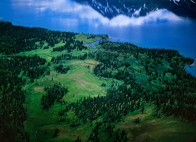
SUPPORT THE CAUSE: http://shop.littlebearprod.com/No-Pebble-Mine_c65.htm
Tuesday, October 11, 2016

SUPPORT THE CAUSE: http://shop.littlebearprod.com/No-Pebble-Mine_c65.htm
Tuesday, October 4, 2016

SUPPORT THE CAUSE: http://shop.littlebearprod.com/No-Pebble-Mine_c65.htm
Tuesday, September 27, 2016

SUPPORT THE CAUSE: http://shop.littlebearprod.com/No-Pebble-Mine_c65.htm
Tuesday, September 20, 2016

SUPPORT THE CAUSE: http://shop.littlebearprod.com/No-Pebble-Mine_c65.htm
Tuesday, September 13, 2016

SUPPORT THE CAUSE: http://shop.littlebearprod.com/No-Pebble-Mine_c65.htm
Tuesday, September 6, 2016

SUPPORT THE CAUSE: http://shop.littlebearprod.com/No-Pebble-Mine_c65.htm
Tuesday, August 30, 2016

SUPPORT THE CAUSE: http://shop.littlebearprod.com/No-Pebble-Mine_c65.htm

SUPPORT THE CAUSE: http://shop.littlebearprod.com/No-Pebble-Mine_c65.htm
Tuesday, August 16, 2016

SUPPORT THE CAUSE: http://shop.littlebearprod.com/No-Pebble-Mine_c65.htm
Tuesday, August 9, 2016

SUPPORT THE CAUSE: http://shop.littlebearprod.com/No-Pebble-Mine_c65.htm
Tuesday, August 2, 2016

SUPPORT THE CAUSE: http://shop.littlebearprod.com/No-Pebble-Mine_c65.htm

SUPPORT THE CAUSE: http://shop.littlebearprod.com/No-Pebble-Mine_c65.htm
~Robert Glenn Ketchum
Tuesday, March 5, 2019

NO PEBBLE MINE #338: Because we are in a boat with a shallow draft and a lot of power, we continue to push up into the headwaters of the Goodnews River, even through some sketchy shallows, and rapids. My two hosts, enforcement officers from the ADF&G, patrol this river daily though, so they know exactly what we are doing, and I am just along for the ride and the view. We are now at a point where the embankments have flattened out, and the tundra rolls off in every direction around us. The Goodnews is also shallow, narrow, and meandering enough to make it impossible for a plane to land, so we are beyond the realm of floaters, fishing and camping. There is no one else out here but us,..and a lot of animals. Because the terrain is navigable, they want me to take a hike onshore they think will prove interesting. Of course, they tag along as my bodyguards, both sporting holstered pistols, and rifles over their shoulders. The consensus here is that the views are expansive enough that we will see whatever animals (bear) might be out there, before they become of danger to us. We do see several moose, we hear wolves, and then over one of the rolls in the landscape, this nicely constructed beaver pond and lodge complex appears, replete with busy beavers, another moose, and several eagles. In a light, on-and-off rain, we snack here while watching the activity, and then work our way back to the boat.
photograph(s) © copyright, ROBERT GLENN KETCHUM, 2019, @RbtGlennKetchum @LittleBearProd @NRDC @OrvisFlyFishing #NoPebbleMine #LittleBearProd
Follow Robert Glenn Ketchum's Photographic Activism Online:
LINKEDIN: linkedin.com/in/RbtGlennKetchum
FACEBOOK: facebook.com/RobertGlennKetchum
FACEBOOK: facebook.com/NoPebbleMine.photos
TWITTER: twitter.com/RbtGlennKetchum
SOCIAL MEDIA by #LittleBearProd: @LittleBearProd
Tuesday, February 26, 2019

NO PEBBLE MINE #337: The spectacular sunset of the previous night (last two posts) ushers in weather from the Pacific, so we awake to a blustery, cold, and rainy morning. It is nice to be able to have a casual breakfast in the warmth of the cabin in which my two hosts reside while doing their summer enforcement patrols on the Goodnews River for the Alaska Department of Fish & Game. Back out in the boat and on the river, it is another story, and we all fleece-up and put on raingear. Their camp is situated in the last really broad section of the river, and as we move upriver, closer to headwaters, the river narrows, and the banks steepen and grow taller. We do not see many floaters on the river this morning, probably because of the lousy weather, but we do find many still in camp. We are now deeply into Native land, upon which there is no trespass to camp or fish. Nonetheless, we make several stops to inform groups that they need to remove their encampments from the shore, and find a sandbar where they can camp legally. Curious about how enforcement plays out, I ask if the penalty of being fined accomplishes anything, AND what about the houseboat guy we encountered yesterday? They tell me they reported him last night on the radio in the cabin, and Native enforcement officers will deal with him, arresting him for trespass, seizing his illegal fish catch and fish-wheel, and, likely, breaking down his boat. My hosts assure me working it this way will be far more effective, then if they took action. They also point out that many floaters who are fishing, are with local guides, and the guide can loose their license if the floaters break the law.
photograph(s) © copyright, ROBERT GLENN KETCHUM, 2019, @RbtGlennKetchum @LittleBearProd @NRDC @OrvisFlyFishing #NoPebbleMine #LittleBearProd
Follow Robert Glenn Ketchum's Photographic Activism Online:
LINKEDIN: linkedin.com/in/RbtGlennKetchum
FACEBOOK: facebook.com/RobertGlennKetchum
FACEBOOK: facebook.com/NoPebbleMine.photos
TWITTER: twitter.com/RbtGlennKetchum
SOCIAL MEDIA by #LittleBearProd: @LittleBearProd
Tuesday, February 19, 2019

NO PEBBLE MINE #336: I am sure the two Alaska Department of Fish & Game officers, in whose cabin I am having dinner, think I am a little nuts, because I keep leaving our meal to go back outside. As you see in the last post, there is quite a show going on, and this is SUMMER in Alaska, so the show goes on for a LONG time. The sun doesn’t set until 10pm or so. Although the wind does not pick up, the temperature drops dramatically as night falls, causing patches of ground fog to appear, disappear, and re-appear. I assure my hosts that my behavior comes with my job, and it is likely getting great results. I also thank them for hosting me in their very trick camp. The cabin is very cozy, but is too tight to sleep three, so I have my tent and there is a nice soft-sand floor quite close to the cabin where I pitch. As the cabin is relatively bear-proof, they want me to divest my tent of EVERYTHING, so there are no scent traces that might attract a bear,..except for mine. Then, they hand me a shotgun with hand-loaded slug shells, and suggest I keep it next to me “in case.” They do say, however, they have never had a bear visit this bar when they have been here, and frankly, it is Southwest, there are bears everywhere I go. I can’t say that I am used to them, but I have learned to sleep soundly.
photograph(s) © copyright, ROBERT GLENN KETCHUM, 2019, @RbtGlennKetchum @LittleBearProd @NRDC @OrvisFlyFishing #NoPebbleMine #LittleBearProd
Follow Robert Glenn Ketchum's Photographic Activism Online:
LINKEDIN: linkedin.com/in/RbtGlennKetchum
FACEBOOK: facebook.com/RobertGlennKetchum
FACEBOOK: facebook.com/NoPebbleMine.photos
TWITTER: twitter.com/RbtGlennKetchum
SOCIAL MEDIA by #LittleBearProd: @LittleBearProd
Tuesday, February 12, 2019

NO PEBBLE MINE #335: As the two Alaska Department of Fish & Game enforcement officers and I work our way up the Goodnews River, I go ashore and climb low hills in many places, in spite of the unsettling evidence of grizzlies on the first beach at which we stop. The river remains wide, and in many places there are sizable sandbars around which we carefully navigate. One of these, further upstream, hosts our camp. I am amazed at the number of float groups fishing the river, many of whom do not have necessary permits or fishing license. I find it depressing that there are SO many that want to cheat the system. They have come great distances to fish trophy-class waters, for which, apparently, they have little regard, and they refuse to acknowledge there must be management to prevent overfishing. Our most amazing encounter is a 60-ish, white male, who tells us he was born in state, lives part of the year farther north, and then during salmon season, he comes here to fish for his “winter supplies.” The ADF&G officers know him, so we stop to board the houseboat he has built for himself, which is presently anchored to trees on the riverbank. He has no license. He has no permits. He has an illegal fish wheel trap, which he denies using. He also has WAY MORE fish iced than seems even close to legal. YET, he yells at us, saying because he was born in state, none of the laws apply to him, because he had these rights before the laws existed. The officers have heard it before, and issue him several citations. He is one of our last encounters for the day, and about 1/2 hour further upriver, we come to a section with a massive sandbar in the middle that sports a shed, a cabin, a small dock, and a lot of “Alaskan gear.” We are home. As it is getting dark, my hosts start dinner, and I wander out on to the bar to watch the unfolding of the evening’s stunning sunset. We are looking downriver, and to the west. It HAS been a good day on the Goodnews, and now, real food not freeze-dried.
photograph(s) © copyright, ROBERT GLENN KETCHUM, 2019, @RbtGlennKetchum @LittleBearProd @NRDC @OrvisFlyFishing #NoPebbleMine #LittleBearProd
Follow Robert Glenn Ketchum's Photographic Activism Online:
LINKEDIN: linkedin.com/in/RbtGlennKetchum
FACEBOOK: facebook.com/RobertGlennKetchum
FACEBOOK: facebook.com/NoPebbleMine.photos
TWITTER: twitter.com/RbtGlennKetchum
SOCIAL MEDIA by #LittleBearProd: @LittleBearProd
Tuesday, February 5, 2019

NO PEBBLE MINE #334: The two river enforcement officers who are helping me explore the Goodnews drainage and headwaters, have told me that I can go ashore anywhere that looks interesting, so there will be more variation to my shoot, than just from the water. After our first few early morning encounters with float fishermen, checking permits, etc., we come to section of the river with deep current along one shore, but a huge sandbar extending from the other side, and some access to a marsh area, formed in the bend of a meander (previous post). We all disembark on the sandbar, but as we do, I note that both of them break out their shotguns. I have an armed guard! Without the wind off the river, the day is sunny and warm. Being ashore offers me a very different take on the terrain, I make many pictures, and push further back from the river, into the marshy meander. Until we arrive here! It is a nice view of what apparently is a VERY popular area. The female officer also has a biology degree and identifies 9 different species of bird tracks (foreground, middle & right) in the sand. However, there are also some MUCH larger prints, going out of the frame to the left - it is a VERY big grizzly bear, and it has just walked through recently because some of the tracks still hold water. Stopping for this shot makes both my hosts nervous, so they are grateful I do it quickly, and we beat a quiet retreat to the boat. Perhaps it is time to move to another location.
photograph(s) © copyright, ROBERT GLENN KETCHUM, 2019, @RbtGlennKetchum @LittleBearProd @NRDC @OrvisFlyFishing #NoPebbleMine #LittleBearProd
Follow Robert Glenn Ketchum's Photographic Activism Online:
LINKEDIN: linkedin.com/in/RbtGlennKetchum
FACEBOOK: facebook.com/RobertGlennKetchum
FACEBOOK: facebook.com/NoPebbleMine.photos
TWITTER: twitter.com/RbtGlennKetchum
SOCIAL MEDIA by #LittleBearProd: @LittleBearProd
Tuesday, January 29, 2019
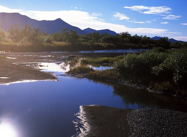
NO PEBBLE MINE #333: The Goodnews is a big, long river that has a considerable volume at its mouth, hence the ADF&G enforcement officers that are helping me explore the drainage, work with a powerful boat that has considerable thrust to forge upstream travel. It also has a fully enclosed cabin to keep us out of the wind, and because the weather is often so horrible. The officers have a job mission to fulfill, which they do EVERY DAY, working from a cabin camp about mid-river. They patrol up and down the river length, checking the endless stream of fishermen that fly in from all over the world to fish southwest Alaska. Some of those obey the laws, have the appropriate permits, and respect the catch limitations, others don’t. Certain ones believe because they are “Alaskan,” they can fish where and when they choose without limits. EVERYONE is armed. It makes my trips with them interesting. Another uniquely Alaskan issue here is Native land trespass, which my associates also enforce. Most fish the Goodnews on 10-day float trips, being dropped by air below the headwaters, and then camping while drifting to Goodnews village to be flown out. However most land on either bank is Native owned, and there is NO trespass. The floaters MUST camp only on river sandbars, which are not always where they might want to be. Many times they also disembark on select river banks to fish prime spots, which is not allowed either. We stop them, explain the rules, and issue expensive tickets. Some people are told to immediately leave the river. Some guide groups are also fined for allowing their guests to abuse the rules. It is an interesting process to watch. When not doing any of that, these officers offer to take me anywhere I might like, and they will stop so I can shoot from the land, whenever that might help.
photograph(s) © copyright, ROBERT GLENN KETCHUM, 2019, @RbtGlennKetchum @LittleBearProd @NRDC @OrvisFlyFishing #NoPebbleMine #LittleBearProd
Follow Robert Glenn Ketchum's Photographic Activism Online:
LINKEDIN: linkedin.com/in/RbtGlennKetchum
FACEBOOK: facebook.com/RobertGlennKetchum
FACEBOOK: facebook.com/NoPebbleMine.photos
TWITTER: twitter.com/RbtGlennKetchum
SOCIAL MEDIA by #LittleBearProd: @LittleBearProd
Tuesday, January 22, 2019

NO PEBBLE MINE #332: I am in the small Native village of Goodnews, awaiting two river enforcement officers from the Alaska Department of Fish and Game to pick me up in their patrol boat, and take me to explore the Goodnews river drainage and headwater. This is the first time I have worked with ADF&G, so I have no idea what to expect, so at the moment, I sit by the small river dock with my gear, waiting, only to be occasionally cruised by teenagers from the village riding 4-wheelers. It is a beautiful, warm day and quite peaceful by the river, so it is very clear when the officers arrive, because I can hear the noise of their engine. There are, indeed, two officers, armed with serious, holstered handguns and wearing badges. One is female. We exchange greetings, they grab my gear, and we are off. With such a great day, I go to work immediately and start shooting, while in-between, we discuss what I am hoping to do with this project. At the start of the trip, basically the delta of the Goodnews, the land is very flat and brushy. There is a downstream wind building that makes the leaves ashore shimmer as it gusts through their branches. It seems to be a good day in Goodnews!
photograph(s) © copyright, ROBERT GLENN KETCHUM, 2019, @RbtGlennKetchum @LittleBearProd @NRDC @OrvisFlyFishing #NoPebbleMine #LittleBearProd
Follow Robert Glenn Ketchum's Photographic Activism Online:
LINKEDIN: linkedin.com/in/RbtGlennKetchum
FACEBOOK: facebook.com/RobertGlennKetchum
FACEBOOK: facebook.com/NoPebbleMine.photos
TWITTER: twitter.com/RbtGlennKetchum
SOCIAL MEDIA by #LittleBearProd: @LittleBearProd
Tuesday, January 15, 2019

NO PEBBLE MINE #331: Delivered to Goodnews by a plane from Dillingham, I await an upriver boat pick-up from colleagues in the Department of Fish and Game. While waiting, I am surveying this small Native village, and considering what it must be like to live here throughout the year - at the edge of the Arctic Circle, on a gravel-scrub-tundra shoreline, facing into the north Pacific, and without much supportive infrastructure to speak of - this is a rugged lifestyle! Of course, everyone fishes. Freshwater fish and spawning salmon are in the Goodnews river, and Goodnews Bay opens into one of the most productive marine fisheries in the world. No one in this village, however, is a “commercial” fisherman. There are no industrial fishing boats here. This is the fishing “fleet” for the village. It is a flotilla of Lund’s! In one of these, a skilled hunter might catch fish, or marine mammals, hunt seals, and raid cliffside bird rookeries for their eggs. It takes a distinct skill set, and some considerable confidence to go out hunting by yourself, in one of these.
photograph(s) © copyright, ROBERT GLENN KETCHUM, 2019, @RbtGlennKetchum @LittleBearProd @NRDC @OrvisFlyFishing #NoPebbleMine #LittleBearProd
Follow Robert Glenn Ketchum's Photographic Activism Online:
LINKEDIN: linkedin.com/in/RbtGlennKetchum
FACEBOOK: facebook.com/RobertGlennKetchum
FACEBOOK: facebook.com/NoPebbleMine.photos
TWITTER: twitter.com/RbtGlennKetchum
SOCIAL MEDIA by #LittleBearProd: @LittleBearProd
Tuesday, January 8, 2019

NO PEBBLE MINE #330: The Native village of Goodnews sits at the confluence of the Goodnews river, and the ocean, in a large bay that faces directly into the northern end of Bristol Bay and the north Pacific. There is a boat access area at the river, and a dirt airstrip that parallels the river, both set slightly off from the town. No streets are paved, and everyone rides 4-wheelers. There are no cars. There is a small store, and a laundry, but there are no restaurants, and there are no hotels. I am told if I have to overnight here because of weather, the best place to sleep is the floor of the laundry. From my current vantage, the surrounding refuge seems comprised of rolling hills, but as I travel upriver, I will discover it much more mountainous closer to the headwaters. At the moment, however, I have been delivered here with a load of gear and food, and I am awaiting rangers from the Department of Fish and Game to pick me up in their boat. They travel this river regularly because it is a world class fishing destination, and they check permits, catch numbers, and violations of trespass on Native land. I am going to hang with them for a few days and explore the watershed.
photograph(s) © copyright, ROBERT GLENN KETCHUM, 2019, @RbtGlennKetchum @LittleBearProd @NRDC @OrvisFlyFishing #NoPebbleMine #LittleBearProd
Follow Robert Glenn Ketchum's Photographic Activism Online:
LINKEDIN: linkedin.com/in/RbtGlennKetchum
FACEBOOK: facebook.com/RobertGlennKetchum
FACEBOOK: facebook.com/NoPebbleMine.photos
TWITTER: twitter.com/RbtGlennKetchum
SOCIAL MEDIA by #LittleBearProd: @LittleBearProd
Tuesday, January 1, 2019

NO PEBBLE MINE #329: In the last post, I mention the wild beauty of the miles and miles of coastline in the Togiak National Wildlife Refuge, which we will eventually fly above, but now, I am going to put us on the ground to float a few principal rivers. Above is the tidal estuary of a river that I do NOT float, the Kulukak, but it is certainly a luxuriant landscape. I advise you once again to be sure and follow the link, AND to use the + - to get ASTOUNDING detail at high magnification. This river system, like the Snake river I posted last week, is a stunning abstraction from the aerial perspective, and these maps are such remarkable tools. If you do go to the map in the link, zoom way out and follow the coastline north (to the left). After a substantial bit of rugged shoreline, you will see Togiak (a Native village), then another, Platinum, followed by Goodnews Bay, and the small Native village of Goodnews. This will be where I begin an upriver trip to explore the Goodnews river system.
photograph(s) © copyright, ROBERT GLENN KETCHUM, 2019, @RbtGlennKetchum @LittleBearProd @NRDC @OrvisFlyFishing #NoPebbleMine #LittleBearProd
Follow Robert Glenn Ketchum's Photographic Activism Online:
LINKEDIN: linkedin.com/in/RbtGlennKetchum
FACEBOOK: facebook.com/RobertGlennKetchum
FACEBOOK: facebook.com/NoPebbleMine.photos
TWITTER: twitter.com/RbtGlennKetchum
SOCIAL MEDIA by #LittleBearProd: @LittleBearProd
Tuesday, December 25, 2018

NO PEBBLE MINE #328: At the southern, eastern boundaries of the Togiak National Wildlife Refuge, the mountains subside and tundra plains slope down to the shore of the Nushagak River and Bristol Bay. This does not mean fewer rivers than elsewhere in the refuge, it just means the rivers here have more room to meander. This is the Snake. Muddy, slow-moving, often looping back upon itself, it is an amazing graphic to be seen from above. I hope you will take advantage of the Google map links I provide. In the VERY hi-def satellite view, the Google maps reveal some beautiful abstractions of these rivers and their deltas. Be sure to use the + - features to enlarge some these very visual, natural systems. I am sure you have noticed the profusion of small lakes as well. Wait until our travels take us out along the coast. Those pictures are coming soon, and they reveal a spectacular, and lake-lined coast, with big estuaries, and miles-long beaches (where at one point I saw two grizzly bears feeding on a dead whale that washed up on the beach).
photograph(s) © copyright, ROBERT GLENN KETCHUM, 2018, @RbtGlennKetchum @LittleBearProd @NRDC @OrvisFlyFishing #NoPebbleMine #LittleBearProd
Follow Robert Glenn Ketchum's Photographic Activism Online:
LINKEDIN: linkedin.com/in/RbtGlennKetchum
FACEBOOK: facebook.com/RobertGlennKetchum
FACEBOOK: facebook.com/NoPebbleMine.photos
TWITTER: twitter.com/RbtGlennKetchum
SOCIAL MEDIA by #LittleBearProd: @LittleBearProd
Tuesday, December 18, 2018

NO PEBBLE MINE #327: I fly over the Togiak National Wildlife Refuge many, many times in four years of work. Sometimes it is a flight-see, other times are en route to river floats, or visits to villages. I fly with numerous pilots, all of them local. Above the refuge, they all know the names of the largest rivers, but few can even come close to naming the myriad of smaller ones..and we are not talking streams, these are rivers. I did ask if anyone does know all the names, and was assured that each of the villages, and there are many in the refuge, knows the specific river names around them very well, and their hunters may know more because they travel farther. Nonetheless, the consensus is, no one knows them all except the mapmakers. This is a landscape that hosts the greatest freshwater diversity in North America, funneling all this down into Bristol Bay, and creating the most productive salmon fishery in the history of the world. NO PEBBLE MINE! This is a world of fish.
photograph(s) © copyright, ROBERT GLENN KETCHUM, 2018, @RbtGlennKetchum @LittleBearProd @NRDC @OrvisFlyFishing #NoPebbleMine #LittleBearProd
Follow Robert Glenn Ketchum's Photographic Activism Online:
LINKEDIN: linkedin.com/in/RbtGlennKetchum
FACEBOOK: facebook.com/RobertGlennKetchum
FACEBOOK: facebook.com/NoPebbleMine.photos
TWITTER: twitter.com/RbtGlennKetchum
SOCIAL MEDIA by #LittleBearProd: @LittleBearProd
Tuesday, December 11, 2018

NO PEBBLE MINE #326: Over 4-MILLION acres in size, the backcountry of the Togiak National Wildlife Refuge is an endless expanse of mountains and valleys, rivers, lakes, and wetlands. Rivers are EVERYWHERE! Rivers that appear sizable beneath the wing, flow into bigger rivers that are more impressive,..and then the “big” river flows into one that is even larger. So much flowing water. Even the large rivers are numerous. The Kanektok, Goodnews, Kanik, Kulukak, Negukthlik, Togiak, Kinegnak, and Snake (there is always a Snake) are so large they have huge tidal deltas and complexes of wetlands where they meet the coast. They exist, however, because THOUSANDS of streams and tributaries feed their headwaters.
photograph(s) © copyright, ROBERT GLENN KETCHUM, 2018, @RbtGlennKetchum @LittleBearProd @NRDC @OrvisFlyFishing #NoPebbleMine #LittleBearProd
Follow Robert Glenn Ketchum's Photographic Activism Online:
LINKEDIN: linkedin.com/in/RbtGlennKetchum
FACEBOOK: facebook.com/RobertGlennKetchum
FACEBOOK: facebook.com/NoPebbleMine.photos
TWITTER: twitter.com/RbtGlennKetchum
SOCIAL MEDIA by #LittleBearProd: @LittleBearProd
Tuesday, December 4, 2018

NO PEBBLE MINE #325: I do overflights of the Togiak National Wildlife Refuge numerous times and in very different seasons. I also float most of the major rivers. This imaginary flight will now bleed those experiences together in this blog. The last two posts feature one of my most dramatic morning arrivals in the refuge, resplendent in brilliant fall colors. Here is the other extreme. This is early spring. It rains almost everyday. The landscape is an amazing shade of emerald green, and the insect population is off-the-chart. It is good to be airborne. The Togiak refuge is home to a number of Native villages, some of which I will use as staging areas for my river floats. Those villages, and all the floating occurs on large rivers, but the backcountry is just a labyrinth of smaller streams and valleys wending their way through various ranges. This is big country, and fish, bugs, and much larger animals are everywhere.
photograph(s) © copyright, ROBERT GLENN KETCHUM, 2018, @RbtGlennKetchum @LittleBearProd @NRDC @OrvisFlyFishing #NoPebbleMine #LittleBearProd
Follow Robert Glenn Ketchum's Photographic Activism Online:
LINKEDIN: linkedin.com/in/RbtGlennKetchum
FACEBOOK: facebook.com/RobertGlennKetchum
FACEBOOK: facebook.com/NoPebbleMine.photos
TWITTER: twitter.com/RbtGlennKetchum
SOCIAL MEDIA by #LittleBearProd: @LittleBearProd
Tuesday, November 27, 2018

NO PEBBLE MINE #324: Our flight into the headwaters of the upper Togiak River afford of spectacular view of the plain of the Togiak National Wildlife Refuge (last post), but the river is still too small for our plane to land upon, so we turn west, following the Togiak downstream toward the Pacific. This view is now west, and all of that is the refuge, as well, including the mountains. My work around Bristol Bay has opened a world of new places to me that I can only define with superlatives. Wood-Tikchik State Park, at 1.6million acres, is the largest state park in the US. Togiak is THREE TIMES LARGER than Tikchik, encompassing nearly 4,300,000 acres. That is a lot of room for the buffalo to roam,..or in this case the moose, bear, caribou, and wolves. Lest we not forget the resplendent fishery. Our flight west follows the Togiak until it grows larger and broadens. Above you can see a river fed valley full of fall trees, feeding into the Togiak, swelling it evermore in size. Not much farther ahead, our flight sets down on the river, and the rest of the day is spent successfully fishing. On the eve, we return to Tikchik Narrows Lodge to eat our catch. In my next post, our imaginary flight above Togiak continues over its far reaches, so if you enjoy the view of still wild, untrammeled places, stay tuned.
photograph(s) © copyright, ROBERT GLENN KETCHUM, 2018, @RbtGlennKetchum @LittleBearProd @NRDC @OrvisFlyFishing #NoPebbleMine #LittleBearProd
Follow Robert Glenn Ketchum's Photographic Activism Online:
LINKEDIN: linkedin.com/in/RbtGlennKetchum
FACEBOOK: facebook.com/RobertGlennKetchum
FACEBOOK: facebook.com/NoPebbleMine.photos
TWITTER: twitter.com/RbtGlennKetchum
SOCIAL MEDIA by #LittleBearProd: @LittleBearProd
Tuesday, November 20, 2018

NO PEBBLE MINE #323: Over several years, I have many flights over the Togiak National Wildlife Refuge, so I am witness to the seasonal changes. Perhaps the most spectacular of these moments, occurs following the path of our present, imaginary flight. I am with fishing guests from Tikchik Narrows Lodge, and we have flown over the Wood Mountains, out of Wood-Tikchik State Park, and into Togiak, to fly fish on the upper Togiak River. All such fishing adventures begin early in the day from the lodge, and the morning sun is just awakening the plains of the refuge, when we arrive. It is a stunningly clear day, and not only does it make the light brilliant and the fall colors glow, it gives all of us a great sense of how large the refuge is. Everything you see here is part of it, including all of those mountains... and this view is north. There is much more west, to the coast. Above, you can also see a stream (coming from the left) joining the headwaters of the upper Togiak River.
photograph(s) © copyright, ROBERT GLENN KETCHUM, 2018, @RbtGlennKetchum @LittleBearProd @NRDC @OrvisFlyFishing #NoPebbleMine #LittleBearProd
Follow Robert Glenn Ketchum's Photographic Activism Online:
LINKEDIN: linkedin.com/in/RbtGlennKetchum
FACEBOOK: facebook.com/RobertGlennKetchum
FACEBOOK: facebook.com/NoPebbleMine.photos
TWITTER: twitter.com/RbtGlennKetchum
SOCIAL MEDIA by #LittleBearProd: @LittleBearProd
Tuesday, November 13, 2018

NO PEBBLE MINE #322: As we fly into the Togiak National Wildlife Refuge, the terrain and habitat change in a noticeable way. For one, the refuge is more expansive than Wood-Tikchik State Park, where we have just been. It is easily two or three times larger, and that difference is visible immediately from the area. The valley we are following “down” from the mountains, broadens as it gets lower, finally spilling onto the basin floor that forms the refuge. Below our wings, several streams merge, and I can see others pouring in from elsewhere. Then, a number of lakes appear, into which these drainages are feeding. The pilot tells me that we are in the headwaters of the Togiak River, which we will now follow to the coast, and these are part of the Upper Togiak Lake(s). This parting view shows the headwater lakes, and looks south and west, back into the distant peaks which are part of Tikchik.
photograph(s) © copyright, ROBERT GLENN KETCHUM, 2018, @RbtGlennKetchum @LittleBearProd @NRDC @OrvisFlyFishing #NoPebbleMine #LittleBearProd
Follow Robert Glenn Ketchum's Photographic Activism Online:
LINKEDIN: linkedin.com/in/RbtGlennKetchum
FACEBOOK: facebook.com/RobertGlennKetchum
FACEBOOK: facebook.com/NoPebbleMine.photos
TWITTER: twitter.com/RbtGlennKetchum
SOCIAL MEDIA by #LittleBearProd: @LittleBearProd
Tuesday, November 6, 2018

NO PEBBLE MINE #321: Similar, but not the same, the landscape beneath our wings suggests the familiar high valleys of Wood-Tikchik State Park, and yet the terrain here seems more expansive and less vertical. The summits are not as rocky, and the bush is more tundra than dense thrash. There is still A LOT of water everywhere, and every valley supports a river system, all of them descending into the Togiak National Wildlife Refuge and ultimately, flowing into the fishery of Bristol Bay. I would never refer to Wood-Tikchik as small, at 1.6-million acres, it is the largest state park in Alaska, and arguably, also in all of North America, BUT as we leave the mountains and enter the refuge, I immediately sense a MUCH LARGER ecosystem at the foot of these new and different mountains, and across this basin to the sea.
photograph(s) © copyright, ROBERT GLENN KETCHUM, 2018, @RbtGlennKetchum @LittleBearProd @NRDC @OrvisFlyFishing #NoPebbleMine #LittleBearProd
Follow Robert Glenn Ketchum's Photographic Activism Online:
LINKEDIN: linkedin.com/in/RbtGlennKetchum
FACEBOOK: facebook.com/RobertGlennKetchum
FACEBOOK: facebook.com/NoPebbleMine.photos
TWITTER: twitter.com/RbtGlennKetchum
SOCIAL MEDIA by #LittleBearProd: @LittleBearProd
Tuesday, October 30, 2018

NO PEBBLE MINE #320: Squalling weather rolls over my pilot and I while we are on the ground at Heart Lake, and after it passes, we agree that we should return to our specific purpose of passing over the Wood River Range and into the Togiak National Wildlife Refuge. As quickly as the rain came, it is gone, and the wind dies down, too, so we are off. As I look out over this terrain, I do not yet realize how alpine, and VERY different it is, from other landscapes I have flown above, but that will now change quickly. We are headed north and west, leaving the Wood mountains behind, and soon to see a similar, but not the same, rugged, wild terrain that forms the refuge. Togiak is headwaters to numerous rivers that feed into the Bristol Bay fishery, and we will now explore them from above. I float most of them as well. Stay tuned!
photograph(s) © copyright, ROBERT GLENN KETCHUM, 2018, @RbtGlennKetchum @LittleBearProd @NRDC @OrvisFlyFishing #NoPebbleMine #LittleBearProd
Follow Robert Glenn Ketchum's Photographic Activism Online:
LINKEDIN: linkedin.com/in/RbtGlennKetchum
FACEBOOK: facebook.com/RobertGlennKetchum
FACEBOOK: facebook.com/NoPebbleMine.photos
TWITTER: twitter.com/RbtGlennKetchum
SOCIAL MEDIA by #LittleBearProd: @LittleBearProd
_____________________________________________________
Tuesday, October 23, 2018

NO PEBBLE MINE #319: Camera and tripod in hand, I wander around the shoreline of Heart Lake for a distance, mostly caught up in the rain saturated fall colors of the tundra, in contrast to the pale blue color of the water. Sometimes you just work too hard to see what you expect, and you fail to see “the surprise.” There always is one. This is mine for the day (above). Eventually the weather begins shifting back into rain, so I begin a return to the plane. In so doing, I surmount a small rise of tundra, and am presented with this POV. I am sorry my blog has no sound, because at this moment, the wind is, literally, howling around those summits, and the clouds are being torn into tatters. Camping up here would be a VERY interesting experience. For now, however, it is about to storm on us, and my pilot and I are on our way into the Togiak National Wildlife Refuge. We have just been sidetracked up here for awhile... then this happened!
photograph(s) © copyright, ROBERT GLENN KETCHUM, 2018, @RbtGlennKetchum @LittleBearProd @NRDC @OrvisFlyFishing #NoPebbleMine #LittleBearProd
Follow Robert Glenn Ketchum's Photographic Activism Online:
LINKEDIN: linkedin.com/in/RbtGlennKetchum
FACEBOOK: facebook.com/RobertGlennKetchum
FACEBOOK: facebook.com/NoPebbleMine.photos
TWITTER: twitter.com/RbtGlennKetchum
SOCIAL MEDIA by #LittleBearProd: @LittleBearProd
_____________________________________________________
Tuesday, October 16, 2018

NO PEBBLE MINE #318: As we follow the meandering valley beneath our wing, the water in the river becomes increasingly pale blue in color, indicating it contains little soil and is almost entirely glacial meltwater. We are also not far above the ground, but we ARE high in altitude. The dense bush gives way to tundra and exposed granite,..and what the pilot says is Heart Lake, appears. It is jewel-like,..a pale sapphire blue, nestled into a colorfully dappled, tundra-lichen bowl, surrounded on three sides by impressive summits. It is easily large enough for a landing and so we do. Disembarking to shore is simple, and coincides nicely with a break in the weather, When the sun comes out, it causes the rain-droplet-covered tundra to sparkle. There is lichen everywhere, and in every color and shape imaginable. This is clearly an attractive place to feed if you are a caribou (they eat mostly lichen), and with the dense Alaskan bush at bay, hunters can move around a greater range of the landscape, so I understand why he brings his hunting campers here. Today, I am armed, and shooting,..but not at caribou.
photograph(s) © copyright, ROBERT GLENN KETCHUM, 2018, @RbtGlennKetchum @LittleBearProd @NRDC @OrvisFlyFishing #NoPebbleMine #LittleBearProd
Follow Robert Glenn Ketchum's Photographic Activism Online:
LINKEDIN: linkedin.com/in/RbtGlennKetchum
FACEBOOK: facebook.com/RobertGlennKetchum
FACEBOOK: facebook.com/NoPebbleMine.photos
TWITTER: twitter.com/RbtGlennKetchum
SOCIAL MEDIA by #LittleBearProd: @LittleBearProd
_____________________________________________________
Tuesday, October 9, 2018

NO PEBBLE MINE #317: Wending our way through high mountain valleys between Wood-Tikchik State Park and the Togiak National Wildlife Refuge, our flight encounters spats of nasty weather, which then give way to spotty sunlight, before encountering another round of rain squalls. It is not risky flying because visibility is good, and it IS beautiful, as the landscape beneath the wings, sparkles and glows in lush, vibrant, VERY wet, saturated color. Smaller, more shallow lakes are now starting to give way to larger bodies of water, and this is the first one we flyover that is large enough to land upon. My pilot says we will continue to another that offers “access,” so that I can walk around a bit. He thinks this lake is surrounded by such dense bush, just getting ashore will be difficult.
photograph(s) © copyright, ROBERT GLENN KETCHUM, 2018, @RbtGlennKetchum @LittleBearProd @NRDC @OrvisFlyFishing #NoPebbleMine #LittleBearProd
Follow Robert Glenn Ketchum's Photographic Activism Online:
LINKEDIN: linkedin.com/in/RbtGlennKetchum
FACEBOOK: facebook.com/RobertGlennKetchum
FACEBOOK: facebook.com/NoPebbleMine.photos
TWITTER: twitter.com/RbtGlennKetchum
SOCIAL MEDIA by #LittleBearProd: @LittleBearProd
_____________________________________________________
Tuesday, October 2, 2018

NO PEBBLE MINE #316: As we depart the huge rolling, tundra-covered hills, and approach a more mountainous terrain, the weather intensifies and there is a good deal of rain in passing squalls. The landscape is becoming evermore alpine, and trees have all but disappeared. The expansive tundra looks like green velvet in the haze of rain curtains. Larger lakes than we have previously seen, appear, but none of them are big enough for us to land. Nonetheless, I know this pilot has been here before, so we are not flying “blind.” He does have an intended destination where he expects to put me on the ground. This past hour has been one of the most remarkable journeys I have ever made. Aside from A LOT of animals, especially caribou and bear, there is nothing in this alpine world but undisturbed wildness/wilderness. I would gladly come back here to camp at some point, but that is not happening this day. However, I am about to find a great campsite where I can get out and “stretch my legs.” More likely, I am going to take my cameras and run around like a wildman, trying to drink in this amazing place from ground level.
photograph(s) © copyright, ROBERT GLENN KETCHUM, 2018, @RbtGlennKetchum @LittleBearProd @NRDC @OrvisFlyFishing #NoPebbleMine #LittleBearProd
Follow Robert Glenn Ketchum's Photographic Activism Online:
LINKEDIN: linkedin.com/in/RbtGlennKetchum
FACEBOOK: facebook.com/RobertGlennKetchum
FACEBOOK: facebook.com/NoPebbleMine.photos
TWITTER: twitter.com/RbtGlennKetchum
SOCIAL MEDIA by #LittleBearProd: @LittleBearProd
_____________________________________________________
Tuesday, September 25, 2018

NO PEBBLE MINE #315: As we fly toward what my pilot promises will be a lake large enough to land upon, we follow this river valley for a good distance. I am VERY SURE this is one of the most extraordinary and beautiful places I have ever seen, and certainly one of the wildest and most untouched. This is BIG water! Those are large, deciduous trees growing up the embankment in the immediate foreground. My pilot says he knows there is great fishing down there, but no one is crazy enough to try and get to it. As you can see by following the direction of this river, it is really a gorge that runs for a couple of miles, and then it merges into a much broader river valley. Our flight will follow the gorge to that valley, and then we will bear to the right, following the broader valley out of the rolling hills and into a part of this terrain that is more mountainous. That is where he says we will find a lake large enough that we can land.
photograph(s) © copyright, ROBERT GLENN KETCHUM, 2018, @RbtGlennKetchum @LittleBearProd @NRDC @OrvisFlyFishing #NoPebbleMine #LittleBearProd
Follow Robert Glenn Ketchum's Photographic Activism Online:
LINKEDIN: linkedin.com/in/RbtGlennKetchum
FACEBOOK: facebook.com/RobertGlennKetchum
FACEBOOK: facebook.com/NoPebbleMine.photos
TWITTER: twitter.com/RbtGlennKetchum
SOCIAL MEDIA by #LittleBearProd: @LittleBearProd
_____________________________________________________
Tuesday, September 18, 2018

NO PEBBLE MINE #314: My pilot tells me that he occasionally brings hunters up into this world of huge, tundra-covered rolling hills, and lush river valleys, but he notes that there are only a few points of access for them, and most of the terrain is SO untracked and rugged, that it limits their ability to move about. Obviously, there are no landing strips up here, so we are headed for a lake to land upon, so that I can get out on the ground and have a look around. I do see some small lakes, and occasionally clusters of tundra ponds, but nothing in my field of view is big enough to host a landing. A pilot needs a lake of a certain size to accommodate both a landing AND a take-off, and since we have entered this domain, I have not seen a big enough body of water for us to put down. Nonetheless, he assures me we are headed towards one, so we fly on, slowly approaching some very pronounced summits.
photograph(s) © copyright, ROBERT GLENN KETCHUM, 2018, @RbtGlennKetchum @LittleBearProd @NRDC @OrvisFlyFishing #NoPebbleMine #LittleBearProd
Follow Robert Glenn Ketchum's Photographic Activism Online:
LINKEDIN: linkedin.com/in/RbtGlennKetchum
FACEBOOK: facebook.com/RobertGlennKetchum
FACEBOOK: facebook.com/NoPebbleMine.photos
TWITTER: twitter.com/RbtGlennKetchum
SOCIAL MEDIA by #LittleBearProd: @LittleBearProd
_____________________________________________________
Tuesday, September 11, 2018

NO PEBBLE MINE #313: On the day of this flight, you can see that there is a lot of weather rolling through, but the clouds remain high and our flying visibility is good,..sometimes even JUST AMAZING! as a spot of sunlight illuminates one of the verdant valleys in the “lost world” we are now above. As always, scale here is difficult to determine until you are down on the ground, but that is a BIG river and a valley that looks like a set designed for “Game Of Thrones.” As we round the corner of the shadowed foothills to the right, we find a small herd of caribou (15) grazing in the tundra below, and a little further down this valley, two bear are playing in the river. I am excited that we might land, as I would like to see if you can walk around in this terrain, and I DO want to have a ground-level sense of this place.
photograph(s) © copyright, ROBERT GLENN KETCHUM, 2018, @RbtGlennKetchum @LittleBearProd @NRDC @OrvisFlyFishing #NoPebbleMine #LittleBearProd
Follow Robert Glenn Ketchum's Photographic Activism Online:
LINKEDIN: linkedin.com/in/RbtGlennKetchum
FACEBOOK: facebook.com/RobertGlennKetchum
FACEBOOK: facebook.com/NoPebbleMine.photos
TWITTER: twitter.com/RbtGlennKetchum
SOCIAL MEDIA by #LittleBearProd: @LittleBearProd
_____________________________________________________
Tuesday, September 4, 2018

NO PEBBLE MINE #312: As we fly on over this new (to me), high elevation terrain of tundra and rolling domes that marks our departure from Wood-Tikchik State Park, and our entrance into Togiak National Wildlife Refuge, I am surprised by this area my pilot refers to as a “lost world.” It is very different from the ruggedness of the Wood Mountains. He says on rare occasions he brings hunters into these high plateaus to pursue moose and caribou, but mostly, this place is just VERY wild. When I ask about landing, he says we will soon see some lakes, and we will land on one of them to “get out and stretch.” In the meantime, the hills and valleys continue to roll by beneath the wings.
photograph(s) © copyright, ROBERT GLENN KETCHUM, 2018, @RbtGlennKetchum @LittleBearProd @NRDC @OrvisFlyFishing #NoPebbleMine #LittleBearProd
Follow Robert Glenn Ketchum's Photographic Activism Online:
LINKEDIN: linkedin.com/in/RbtGlennKetchum
FACEBOOK: facebook.com/RobertGlennKetchum
FACEBOOK: facebook.com/NoPebbleMine.photos
TWITTER: twitter.com/RbtGlennKetchum
SOCIAL MEDIA by #LittleBearProd: @LittleBearProd
Tuesday, August 28, 2018

NO PEBBLE MINE #311: As our flight leaves Wood-Tikchik State Park and flies northeast over the Wood Mountains and into Togiak National Wildlife Refuge, I am surprised by the terrain change. The summits of the Wood Mountains are rugged, and in many places still hold snow. To cross over them we have risen through high mountain valleys, often cascading with water. Now, we have entered an entirely different world. With the more ragged peaks fading behind us, we are suddenly over a high elevation terrain of rolling hills, broad valleys, and endless tundra but few trees. The pilot explains that these high valleys are prime moose and caribou hunting, and that so few people come up here, it is like a “lost world."
photograph(s) © copyright, ROBERT GLENN KETCHUM, 2018, @RbtGlennKetchum @LittleBearProd @NRDC @OrvisFlyFishing #NoPebbleMine #LittleBearProd
Follow Robert Glenn Ketchum's Photographic Activism Online:
LINKEDIN: linkedin.com/in/RbtGlennKetchum
FACEBOOK: facebook.com/RobertGlennKetchum
FACEBOOK: facebook.com/NoPebbleMine.photos
TWITTER: twitter.com/RbtGlennKetchum
SOCIAL MEDIA by #LittleBearProd: @LittleBearProd
_____________________________________________________
Tuesday, August 21, 2018

NO PEBBLE MINE #310: Nearly to the top of the Wood Mountains and out of Wood-Tikchik State Park, into Togiak National Wildlife Refuge, the terrain beneath the wing is in transition. The green thrash and tundra openings are giving way to rock and boulder scree. Caribou can be seen quite often, and bear are wandering high meadows, gorging on berries and carrion from winter-kill. This is a remarkable flight on a good weather day, but on a bad day it can be very unsettling. Winds in these high valleys come abruptly from differing directions, and when I was flying in the small SuperCub back in the park (posts #279-299), those gusts really surprised us and pushed us around. The last post offered some scale by pointing out a herd of caribou on a snowfield, so try this - do you see the waterfall in the lower third of this frame? How big is that?
photograph(s) © copyright, ROBERT GLENN KETCHUM, 2018, @RbtGlennKetchum @LittleBearProd @NRDC @OrvisFlyFishing #NoPebbleMine #LittleBearProd
Follow Robert Glenn Ketchum's Photographic Activism Online:
LINKEDIN: linkedin.com/in/RbtGlennKetchum
FACEBOOK: facebook.com/RobertGlennKetchum
FACEBOOK: facebook.com/NoPebbleMine.photos
TWITTER: twitter.com/RbtGlennKetchum
SOCIAL MEDIA by #LittleBearProd: @LittleBearProd
_____________________________________________________
Tuesday, August 14, 2018

NO PEBBLE MINE #309: Ascending evermore rapidly now, our “flight” from Wood-Tikchik State Park over the mountains and into the adjacent Togiak National Wildlife Refuge finally reaches true alpine. Summits surround us, and side-valleys plunge back into basins like the one in this image. Although just barely visible in this shot, note the dark dot on the first big snowfield at the bottom of the frame. That is 25-30 caribou, lying down on the snow to escape being bitten incessantly by mosquitoes and bot flies. Amazingly, higher up in the range there are places to land, and pilots bring caribou hunters in regularly, to camp and hunt.
photograph(s) © copyright, ROBERT GLENN KETCHUM, 2018, @RbtGlennKetchum @LittleBearProd @NRDC @OrvisFlyFishing #NoPebbleMine #LittleBearProd
Follow Robert Glenn Ketchum's Photographic Activism Online:
FACEBOOK: http://www.facebook.com/NoPebbleMine.photos
FACEBOOK: http://www.facebook.com/RobertGlennKetchum
FACEBOOK: http://www.facebook.com/RobertGlennKetchum
SOCIAL MEDIA by #LittleBearProd @LittleBearProd
Tuesday, August 7, 2018

NO PEBBLE MINE #308: Our “flight” is in the last stages of leaving Wood-Tikchik State Park, and flying over the Wood Mountains, into the Togiak National Wildlife Refuge. The previous posts gave us views of the big lakes, expansive tundra, and broad lower valleys of the park. Now, we are ever-ascending, and although we are not yet alpine, this is a VAST elevated river valley that we are following “up.” That is significant whitewater down there. That river is raging, and surely, snow-melt cold. What a world! I wonder if any kayakers have ever tried to run this?
photograph(s) © copyright, ROBERT GLENN KETCHUM, 2018, @RbtGlennKetchum @LittleBearProd @NRDC @OrvisFlyFishing #NoPebbleMine #LittleBearProd
Follow Robert Glenn Ketchum's Photographic Activism Online:
LINKEDIN: linkedin.com/in/RbtGlennKetchum
FACEBOOK: facebook.com/RobertGlennKetchum
FACEBOOK: facebook.com/NoPebbleMine.photos
TWITTER: twitter.com/RbtGlennKetchum
SOCIAL MEDIA by #LittleBearProd: @LittleBearProd
_____________________________________________________
Tuesday, July 31, 2018

NO PEBBLE MINE #307: Leaving the lake shorelines, the DENSE bush is virtually unnavigable, but nonetheless, stunning to view. We are heading north and a bit west, crossing over the Wood Mountains in Wood-Tikchik State Park to enter the backcountry of the Togiak National Wildlife Refuge. As we gain elevation in Tikchik, the terrain not only steepens beneath our wing, but it becomes more rugged. There are many animals below, but few people would want to be down there wandering around. Even this late in the summer season, we will still see snow in places, and as with the park, there is water everywhere. Southwest Alaska is the most pristine, American, river-lake habitat left to our nation. Let’s keep it that way and continue to SAY NO TO THE PEBBLE MIINE.
photograph(s) © copyright, ROBERT GLENN KETCHUM, 2018, @RbtGlennKetchum @LittleBearProd @NRDC @OrvisFlyFishing #NoPebbleMine #LittleBearProd
Follow Robert Glenn Ketchum's Photographic Activism Online:
LINKEDIN: linkedin.com/in/RbtGlennKetchum
FACEBOOK: facebook.com/RobertGlennKetchum
FACEBOOK: facebook.com/NoPebbleMine.photos
TWITTER: twitter.com/RbtGlennKetchum
SOCIAL MEDIA by #LittleBearProd: @LittleBearProd
Tuesday, July 24, 2018

NO PEBBLE MINE #306: As this blog has already explored the backcountry of Wood-Tikchik State Park, some of this transition over the Wood mountains to the Togiak National Wildlife Refuge will seem familiar. Leaving the lakes, our flight follows broad rivers valleys steadily upward into higher elevations. Autumn in Tikchik is an unparalleled display of tundra color that only last about 14-days, so I thought I would leave you with this one last especially luscious shot. What a world! AHH! To be a moose on the loose! Our slow gain in elevation is going to take us from the land of moose, fish, and bear, to a world with caribou and wolves. It is a world of tundra and few trees, but this is the home of alpine lakes, the source collection for much of the water that flows down these valleys.
photograph(s) © copyright, ROBERT GLENN KETCHUM, 2018, @RbtGlennKetchum @LittleBearProd @NRDC @OrvisFlyFishing #NoPebbleMine #LittleBearProd
Follow Robert Glenn Ketchum's Photographic Activism Online:
LINKEDIN: linkedin.com/in/RbtGlennKetchum
FACEBOOK: facebook.com/RobertGlennKetchum
FACEBOOK: facebook.com/NoPebbleMine.photos
TWITTER: twitter.com/RbtGlennKetchum
SOCIAL MEDIA by #LittleBearProd: @LittleBearProd
_____________________________________________________
Tuesday, July 17, 2018

NO PEBBLE MINE #305: As we leave Wood-Tickchik State Park and cross over into the Togiak National Wildlife Refuge, I am taking one last look around at the remarkable landscape that comprises this habitat of rivers, lakes, and mountains, and provides about 1/3 of the headwaters for the Bristol Bay fishery. Togiak will also have lakes, rivers, and magnificent terrain, but there is nowhere else I feel as radiantly alive as this park. Where the lakes are concerned, the fact many in the park come from glacial melt probably affects there constantly startling coloration, that are like few other bodies of water I have flown above. From here our flight rises a bit to follow a broad river valley, and then we will begin to climb towards alpine. Goodbye Tickchik Narrows Lodge, and once again, thank you very much, Bud Hodson, for allowing me to SEE this remarkable place.
photograph(s) © copyright, ROBERT GLENN KETCHUM, 2018, @RbtGlennKetchum @LittleBearProd @NRDC @OrvisFlyFishing #NoPebbleMine #LittleBearProd
Follow Robert Glenn Ketchum's Photographic Activism Online:
LINKEDIN: linkedin.com/in/RbtGlennKetchum
FACEBOOK: facebook.com/RobertGlennKetchum
FACEBOOK: facebook.com/NoPebbleMine.photos
TWITTER: twitter.com/RbtGlennKetchum
SOCIAL MEDIA by #LittleBearProd: @LittleBearProd
_____________________________________________________
Tuesday, July 10, 2018

NO PEBBLE MINE #304: As our imaginary flight departs Wood-Tikchik State Park for the Togiak National Wildlife Refuge, I have a few “favorite “ places that I have come to appreciate in this park that we will pass over. As I said in the last post, the sheer verdancy of Tikchik sends off some kind of living-force radiance, and from the air, that always seems especially extravagant around the edges of the big lakes. The best of these lakes host convoluted shorelines that support beaches with quiet bays, and rolling dome terrain, pocketed with numerous small lakes. This is a difficult landscapes to negotiate on foot, because the vegetation is SO dense, AND there both bear and bugs waiting to have a snack suddenly appear,..you! Nonetheless, this is a wild, living, vibrant wilderness that can be enjoyed and observed. Considering what we have done to most of the planet, it might be a good idea to pay some attention to the ecosystem of Southwest, and LEARN from it, instead of imposing ourselves, yet-once-again, on something that we alter and damage, often permanently. Google this history: start in Nova Scotia, go down the entire eastern seaboard, round Florida into the gulf and across Texas, jump to Baja, then go north along the Pacific coast. These used to be American fisheries, some of the world’s MOST PRODUCTIVE, both in food and jobs. They are almost ALL gone now. What is left?
photograph(s) © copyright, ROBERT GLENN KETCHUM, 2018, @RbtGlennKetchum @LittleBearProd @NRDC @OrvisFlyFishing #NoPebbleMine #LittleBearProd
Follow Robert Glenn Ketchum's Photographic Activism Online:
LINKEDIN: linkedin.com/in/RbtGlennKetchum
FACEBOOK: facebook.com/RobertGlennKetchum
FACEBOOK: facebook.com/NoPebbleMine.photos
TWITTER: twitter.com/RbtGlennKetchum
SOCIAL MEDIA by #LittleBearProd: @LittleBearProd
_____________________________________________________
Tuesday, July 3, 2018

NO PEBBLE MINE #303: Tikchik is more than just the spectacular fall, however, as I have tried to show with the winter images. What I can only hint at in these pictures is something more primal about being in the park. My flights/these images bear witness to creation that is relatively undisturbed and richly evolved. As the glaciers retreat in the higher elevation and the rocks emerge, it is not long before vegetation begins to establish itself. Given the marine influence, the significant rain, warm summers, and long growing hours, life explodes. The tundra establishes. Fish establish and spawn, then die to become super-food for EVERYONE, bears, birds, and TREES! Thickets and cottonwood groves establish along streamsides, other species follow, broadening out across the valley floor. From the backcountry stream headwaters (last post), to the big valley floors with mature rivers, and on to the lakes and plains, what I see in looking back through these images, is magnificent, thriving GROWTH EVERYWHERE. Looking down upon it from a plane while making pictures, I could feel through my eyes, the radiant energy of the world flourishing below, like no other place I have ever visited.
photograph(s) © copyright, ROBERT GLENN KETCHUM, 2018, @RbtGlennKetchum @LittleBearProd @NRDC @OrvisFlyFishing #NoPebbleMine #LittleBearProd
Follow Robert Glenn Ketchum's Photographic Activism Online:
LINKEDIN: linkedin.com/in/RbtGlennKetchum
FACEBOOK: facebook.com/RobertGlennKetchum
FACEBOOK: facebook.com/NoPebbleMine.photos
TWITTER: twitter.com/RbtGlennKetchum
SOCIAL MEDIA by #LittleBearProd: @LittleBearProd
_____________________________________________________
Tuesday, June 26, 2018

NO PEBBLE MINE #302: As this blog is about to transition from Wood-Tikchik State Park into the Togiak National Wildlife Refuge, and we take our last pass over the terrain of Wood-Tikchik, I spent the last few posts reminding everyone why the Southwest area is so unique, and why those resources should not be threatened by the proposed Pebble mine. Now I would like to thank those that helped me create the images you have seen posted. When I was doing the fieldwork for my first book on the area, Rivers Of Life: Southwest Alaska, The Last Great Salmon Fishery, I overflew Wood-Tikchik many times because it accounts for about 1/3 of the Bristol Bay headwaters, including the significant fishery of the Nushagak river. I had many more good pictures from the park, that did not fit the edit for Rivers Of Life, and I remembered my friend, Jim Stratton, who really raved about the beauty of the park, was now the Director of Alaska State Parks. When I called him to ask his interest in a book about the park, he said that he and his office were in, and he would offer help and contacts. Jim went on to contribute the preface for my book, Wood-Tikchik: Alaska’s Largest State Park' Among the contacts to help me access the park, was Bud Hodson, owner of Tikchik Narrows Lodge, whom I have noted many times in these posts. His willingness to allow me a room at the lodge and window seat in his planes gave me the many pictures I hope you have been enjoying. At 71, I have seen a great deal of the world, and I would say, flying over Wood-Tikchik, right after a rain, at the height of fall, is one of the most beautiful.
photograph(s) © copyright, ROBERT GLENN KETCHUM, 2018, @RbtGlennKetchum @LittleBearProd @NRDC @OrvisFlyFishing #NoPebbleMine #LittleBearProd
Follow Robert Glenn Ketchum's Photographic Activism Online:
LINKEDIN: linkedin.com/in/RbtGlennKetchum
FACEBOOK: facebook.com/RobertGlennKetchum
FACEBOOK: facebook.com/NoPebbleMine.photos
TWITTER: twitter.com/RbtGlennKetchum
SOCIAL MEDIA by #LittleBearProd: @LittleBearProd
_____________________________________________________
Tuesday, June 19, 2018

NO PEBBLE MINE #301: The thriving, relatively undisturbed habitat of southwest Alaska hosts a collective of hundreds of rivers, and thousands of lakes that feed into the fishery of Bristol Bay. This is not only THE MOST PRODUCTIVE COMMERCIAL WILD SALMON FISHERY IN THE WORLD, it also harvests record challenging cash-crops of herring, and numerous species of crab that can be found nowhere else. The commercial fishery of Bristol Bay is a $1-BILLION-per-year, RENEWABLE RESOURCE industry that employs over 100,000 people, and the largess spreads to many other states, besides Alaska. This commercial catch is the most obvious part of the economy, and the one most used as a reason to SAY NO TO THE PEBBLE MINE. While I don’t disagree about the value of the jobs and the fishery, it is NOT the whole picture. Southwest's stunningly rich freshwaters provide some of the finest recreational fishing anywhere, and wealthy sportsmen from all over the world spend significant time and money to come here. Further, the least developed aspect of Southwest are the parks, which at the moment are accessible, but barely developed for the public in any great numbers. Yet, a recent fiscal analysis of park tourism surprised many, because it discovered Katmai took in twice the money expected, and demand to visit seems to grow with every passing season. I can tell you personally, these parks rival, or ARE GREATER than any parks in the lower-48 I have visited, and when they are finally intelligently developed, they will generate revenue that will match or exceed any of the others. As importantly, many, many Alaskans fulfill the jobs described above, and more might work in Southwest if the parks are properly developed. Again ALL OF THIS is ANNUALLY RENEWABLE industry,..FOREVER if well managed!
photograph(s) © copyright, ROBERT GLENN KETCHUM, 2018, @RbtGlennKetchum @LittleBearProd @NRDC @OrvisFlyFishing #NoPebbleMine #LittleBearProd
Follow Robert Glenn Ketchum's Photographic Activism Online:
LINKEDIN: linkedin.com/in/RbtGlennKetchum
FACEBOOK: facebook.com/RobertGlennKetchum
FACEBOOK: facebook.com/NoPebbleMine.photos
TWITTER: twitter.com/RbtGlennKetchum
SOCIAL MEDIA by #LittleBearProd: @LittleBearProd
_____________________________________________________
Tuesday, June 12, 2018

NO PEBBLE MINE #300: I am writing a blog about NO PEBBLE MINE, but when I put up pictures like this of Wood-Tikchik State Park, I am trying to point out that this blog’s overall purpose is to “enlighten” those that may be unfamiliar with the ENTIRE area of Southwest, because everything out there is closely interconnected. I want readers to realize what a remarkable and INTACT habitat this is, like few other places on Earth. In this blog, I HAVE posted a picture of the ACTUAL mine site, #30, but that exact location has little to do with the overall impact of the Pebble project that will be more expansive. Returning to this image as an example, Tikchik is a good distance from the mine site, BUT major rivers flowing from Tikchik to the fishery of Bristol Bay, pass below other rivers draining from the proposed mine site. The Pebble Mine is not JUST a pit complex, either. The supportive road system would directly impact Lake Clark National Park, and Lake Iliamna - one of the largest freshwater lakes in the world. I also want readers to understand that other parts of these connected habitats might experience “collateral damage.” Bristol Bay, Katmai, Wood-Tikchik, and Togiak all SHARE pristine air quality, and the rivers they host are some of the most bio-diverse freshwaters in the U.S. To generate power for the Pebble mine, the mine will also dig and burn coal. Burning coal not only contaminates air quality, it puts mercury particles into it, which rain back down into the groundwater system, affecting ALL the lakes and rivers. If you want to argue about the “footprint” of the mine, you need to understand the ENTIRE footprint. You cannot be selective, or A LOT OF JOBS THAT ALREADY EXIST, WILL BE LOST because of the mine!
photograph(s) © copyright, ROBERT GLENN KETCHUM, 2018, @RbtGlennKetchum @LittleBearProd @NRDC @OrvisFlyFishing #NoPebbleMine #LittleBearProd
Follow Robert Glenn Ketchum's Photographic Activism Online:
LINKEDIN: linkedin.com/in/RbtGlennKetchum
FACEBOOK: facebook.com/RobertGlennKetchum
FACEBOOK: facebook.com/NoPebbleMine.photos
TWITTER: twitter.com/RbtGlennKetchum
SOCIAL MEDIA by #LittleBearProd: @LittleBearProd
_____________________________________________________
Tuesday, June 5, 2018

NO PEBBLE MINE #299: My flight returns to the luxury of Tikchik Narrows Lodge, and the next day I fly back to Anchorage, my winter adventure in Southwest, over. This blog is now going to move further west and north, in another imaginary flight that will take one more glorious overview of Wood-Tikchik State Park, and then we will fly across the Wood Mountains, landing on an amazing high plateau. Eventually, we will emerge above the Togiak National Wildlife Refuge. Togiak is yet another of the spectacular wild lands, like Katmai, Lake Clark, and Wood-Tikchik, that this blog has already featured, and which I believe are among the most beautiful, and currently undisturbed ecosystems in North America. Although I understand some of these locations are NOT exactly at the site of the Pebble mine, ALL of these rivers, lakes, and parklands will be impacted by the development of the mine. This blog has been around A LONG TIME, the NEXT post is #300. I posted an image of the ACTUAL MINE SITE in post #30. SINCE THEN, I have been taking readers on a tour of Southwest, because the riches of Bristol Bay have been created by the pristine quality of the surrounding environment.
photograph(s) © copyright, ROBERT GLENN KETCHUM, 2018, @RbtGlennKetchum @LittleBearProd @NRDC @OrvisFlyFishing #NoPebbleMine #LittleBearProd
Follow Robert Glenn Ketchum's Photographic Activism Online:
LINKEDIN: linkedin.com/in/RbtGlennKetchum
FACEBOOK: facebook.com/RobertGlennKetchum
FACEBOOK: facebook.com/NoPebbleMine.photos
TWITTER: twitter.com/RbtGlennKetchum
SOCIAL MEDIA by #LittleBearProd: @LittleBearProd
_____________________________________________________
Tuesday, May 29, 2018

NO PEBBLE MINE #298: As we fly over several other gatherings of moose (is there a Moose Lodge out here?), our flight continues down a broadening river valley, that suddenly, looks familiar. The frozen streams beneath us finally show some open water, and ahead I can see the frozen surface of a big lake. In fact, look carefully at the cluster of trees in the left, middle of this image. You can see MY snowmobile tracks from my on-ground adventure of the previous day. It looks like I almost found moose on my ride, but probably best I didn’t (posts #264-278). At the moment, however, my aerial tour of the winter backcountry of Wood-Tikchik State Park is nearly over and the lodge where I have been encamped is just around the corner to the right as the lake flows. I will return to Anchorage tomorrow, but I have certainly fulfilled my promise to my local friends that I would experience southwest in the winter, and make those pictures part of my description-of-place. Once again, thank you Bud Hodson of Tikchik Narrows Lodge for your support in making this happen.
photograph(s) © copyright, ROBERT GLENN KETCHUM, 2018, @RbtGlennKetchum @LittleBearProd @NRDC @OrvisFlyFishing #NoPebbleMine #LittleBearProd
Follow Robert Glenn Ketchum's Photographic Activism Online:
LINKEDIN: linkedin.com/in/RbtGlennKetchum
FACEBOOK: facebook.com/RobertGlennKetchum
FACEBOOK: facebook.com/NoPebbleMine.photos
TWITTER: twitter.com/RbtGlennKetchum
SOCIAL MEDIA by #LittleBearProd: @LittleBearProd
_____________________________________________________
Tuesday, May 22, 2018

NO PEBBLE MINE #297: With so many trees now about us, my pilot/guide senses a winter habitat that might offer what he is scouting, moose and bear. He is a trophy bear guide and not hunting moose, but he knows moose choose to winter deep into Wood-Tikchik park, surviving off of the browse, and when the first big male bears (think-trophy) awake hungry from hibernation, they will go hunting those moose. Know where the moose are, you will eventually find a big bear. Well, we are "moosed-up" today! Dropping low over the valley as we draw close to the bare thickets of trees and brush sticking through the snow beneath us, immediately tracks become visible EVERYWHERE. Then, we come upon this. 8 cows (female moose), grazing and sleeping together. Flying farther along, we come upon two more large groups,..they are everywhere! This is Moose-a-potamia! My pilot/guide is very happy, and so am I. This has been an astonishing flight.
photograph(s) © copyright, ROBERT GLENN KETCHUM, 2018, @RbtGlennKetchum @LittleBearProd @NRDC @OrvisFlyFishing #NoPebbleMine #LittleBearProd
Follow Robert Glenn Ketchum's Photographic Activism Online:
LINKEDIN: linkedin.com/in/RbtGlennKetchum
FACEBOOK: facebook.com/RobertGlennKetchum
FACEBOOK: facebook.com/NoPebbleMine.photos
TWITTER: twitter.com/RbtGlennKetchum
SOCIAL MEDIA by #LittleBearProd: @LittleBearProd
_____________________________________________________
Tuesday, May 15, 2018

NO PEBBLE MINE #296: Looking in the opposite direction of the previous post, a very different landscape is unfolding. It is more expansive. Summits have become rolling hills, and valley floors have broadened, showing forests of trees. Although still frozen over, I can also see the clear patterns of the rivers as they work their way toward the lakes. Then, I notice something odd going on in the view through my lens. Initially I think the cold has finally caused something technical to happen. Although the general landscape appears to be sharply in-focus, the trees ALL appear to be out-of-focus. I use a manual-focus Pentax 645 when I fly and shoot, so I screw the lens to full extension and back, but nothing changes. The trees still look “fuzzy.” Then, I begin to realize that I am seeing a “forest-of-confusion.” In the bright sunlight, the standing trees are dark, almost silhouettes against the snow. They are also casting strong shadows that are equally dark but going in a contrary direction, so it is setting-off a kind of visual vibration. This day has had quite some sights to see!
photograph(s) © copyright, ROBERT GLENN KETCHUM, 2018, @RbtGlennKetchum @LittleBearProd @NRDC @OrvisFlyFishing #NoPebbleMine #LittleBearProd
Follow Robert Glenn Ketchum's Photographic Activism Online:
SUPPORT THE CAUSE: http://shop.littlebearprod.com/No-Pebble-Mine_c65.htm
SOCIAL MEDIA by @LittleBearProd: http://www.LittleBearProd.com
_____________________________________________________
Tuesday, May 8, 2018

NO PEBBLE MINE #295: As my pilot predicted, I do appreciate my newly elevated perspective, and it does give me a greater sense of the landscape surrounding us. While he is circling this basin, I have been focused on tighter images of the many small creeks feeding into this river valley from numerous side drainages. Now, however, we are out over the broadening valley floor, and it affords me this perspective of the “deeper” park, and the heart of the Wood Mountains, through which we have been flying. Just here, scuttling clouds sweep the peaks, walls, and valley floor with dramatic cloudshadows, and the quality of light is simply astounding. Although he is ostensibly focused on searching for moose and bear, my pilot says once again, and rather under his breathe, “What a f#*@ing great day to be flying!" True dat!
photograph(s) © copyright, ROBERT GLENN KETCHUM, 2018, @RbtGlennKetchum @LittleBearProd @NRDC @OrvisFlyFishing #NoPebbleMine #LittleBearProd
Follow Robert Glenn Ketchum's Photographic Activism Online:
SUPPORT THE CAUSE: http://shop.littlebearprod.com/No-Pebble-Mine_c65.htm
SOCIAL MEDIA by @LittleBearProd: http://www.LittleBearProd.com
_____________________________________________________
Tuesday, May 1, 2018
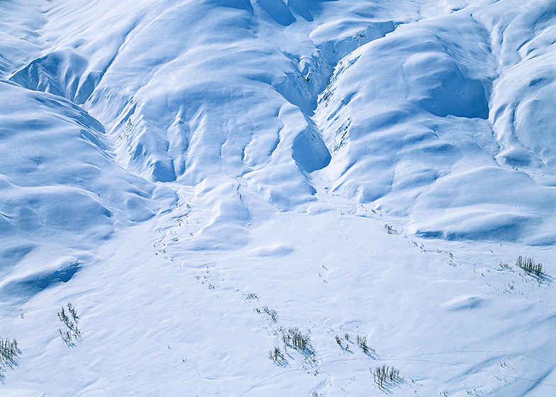
NO PEBBLE MINE #294: This image is a perfect example of what I am describing in the last post. Here I/you can see three small stream drainages (and there is a fourth, just to the left), as the pour down from higher elevations and spill onto the valley floor, where each meanders its way into the larger river beneath our plane. Were we here in any other season, there would be A LOT of flowing water down there. Our flight position is at the highest end of this gradually down-sloping, broad valley. There are numerous trees and bushes showing, but the snow depth is greater. Nonetheless, look carefully in the lower right of this image, as two sets of moose tracks suggest someone has recently done a walk-by munching of those twigs. If you have never seen a moose in person, they are HUGE, and they have VERY long legs that advantage them when snow depth is an issue. Moose DO NOT go down to lower country to winter. They tough out these conditions and survive by grazing on twigs. As big as they are that just not seem possible. Amazing!
photograph(s) © copyright, ROBERT GLENN KETCHUM, 2018, @RbtGlennKetchum @LittleBearProd @NRDC @OrvisFlyFishing #NoPebbleMine #LittleBearProd
Follow Robert Glenn Ketchum's Photographic Activism Online:
SUPPORT THE CAUSE: http://shop.littlebearprod.com/No-Pebble-Mine_c65.htm
SOCIAL MEDIA by @LittleBearProd: http://www.LittleBearProd.com
_____________________________________________________
Tuesday, April 24, 2018

NO PEBBLE MINE #293: Our winter flight above Wood-Tikchik State Park has come to a large, expansive valley floor where many streams and rivers apparently coalesce. My pilot is “scouting” now for his soon-to-come hunting season, so when I ask if we can circle around this basin once, he is happy to oblige. He also suggests we gain some elevation so my POV will give me a more encompassing sense of the surrounding landscape. As we rise higher, I do begin to see the terrain differently. Many small streams meander back into the folds of the foothills through which we have been flying, all of them, drainages coming from the taller peaks we flew past this morning. What I now sense from my new perspective is how so many of them have come together on THIS valley floor, and are forming something bigger under the snow.
photograph(s) © copyright, ROBERT GLENN KETCHUM, 2018, @RbtGlennKetchum @LittleBearProd @NRDC @OrvisFlyFishing #NoPebbleMine #LittleBearProd
Follow Robert Glenn Ketchum's Photographic Activism Online:
SUPPORT THE CAUSE: http://shop.littlebearprod.com/No-Pebble-Mine_c65.htm
SOCIAL MEDIA by @LittleBearProd: http://www.LittleBearProd.com
_____________________________________________________
Tuesday, April 17, 2018

NO PEBBLE MINE #292: As our flight slowly descends to lower elevations in Wood-Tikchik State Park, the terrain beneath the wings continues to broaden. We have been following an obvious river valley, whose shoreline hosts visible shrubs and many large trees. Moose and others have spent a good bit of time here foraging because there are tracks in the snow everywhere. The valley we follow keeps widening, but at one point, we make a small turn and an expansive vista opens. I have become so used to the walls being close, the openness and the wider view take my breath away. We are not above a lake, but we have come to a large valley floor where several rivers coalesce, and my pilot-guide tells me this is a very popular basin for both fishing and hunting, and that we are not far from the lodge at this point. Once again, glad to be in his company, as I have NO IDEA where we are, and nothing looks “familiar."
photograph(s) © copyright, ROBERT GLENN KETCHUM, 2018, @RbtGlennKetchum @LittleBearProd @NRDC @OrvisFlyFishing #NoPebbleMine #LittleBearProd
Follow Robert Glenn Ketchum's Photographic Activism Online:
SUPPORT THE CAUSE: http://shop.littlebearprod.com/No-Pebble-Mine_c65.htm
SOCIAL MEDIA by @LittleBearProd: http://www.LittleBearProd.com
_____________________________________________________
Tuesday, April 10, 2018

NO PEBBLE MINE #291: Although our flight is not over any big lakes as of yet, we have clearly left the summits in the range and are now gliding above foothills and broadening river valleys. There is a lot more visible vegetation, and many animal tracks, but it is the light of the day that is making this flight so amazing. There is no doubt that I have been flying above some remarkable winter terrain, and this small plane affords me quite a view, but again and again, what I see happening are dramatic shifts in color and tone because of the lighting. Further back into the range, the narrow canyons were often in deep shadow, and they were not only cold, but visibly blue. Thin clouds blowing over, cast fleeting shadows on the landscape, constantly changing the shade of it, and now that we are flying over more open expanses, the bright day makes the snow covered slopes, glaringly white. It all looks like carved alabaster!
photograph(s) © copyright, ROBERT GLENN KETCHUM, 2018, @RbtGlennKetchum @LittleBearProd @NRDC @OrvisFlyFishing #NoPebbleMine #LittleBearProd
Follow Robert Glenn Ketchum's Photographic Activism Online:
SUPPORT THE CAUSE: http://shop.littlebearprod.com/No-Pebble-Mine_c65.htm
SOCIAL MEDIA by @LittleBearProd: http://www.LittleBearProd.com
_____________________________________________________
Tuesday, April 3, 2018

NO PEBBLE MINE #290: Along with signs of life (animal tracks crossing the snow) the terrain over which we are flying has begun to open up. The narrow canyons we have been navigating, increasingly meet one another at larger junctions. Although I can not yet see open water, it is clear from patterns in the snow that water is collecting beneath the surface and smaller streams are becoming larger river systems. On the valley floors, snow depth is also decreasing, so more and more vegetation is exposed and that attracts the animals that ARE here to forage on twigs and leaves. My pilot is a bear guide for trophy hunters, and he tells me that very soon, the largest male grizzlies will be the first to awake from hibernation, and emerge into this world VERY hunger. They, too, come to these clusters of shrubs and trees, because they know other animals will come there to feed,..like moose.
photograph(s) © copyright, ROBERT GLENN KETCHUM, 2018, @RbtGlennKetchum @LittleBearProd @NRDC @OrvisFlyFishing #NoPebbleMine #LittleBearProd
Follow Robert Glenn Ketchum's Photographic Activism Online:
SUPPORT THE CAUSE: http://shop.littlebearprod.com/No-Pebble-Mine_c65.htm
SOCIAL MEDIA by @LittleBearProd: http://www.LittleBearProd.com
_____________________________________________________
Tuesday, March 27, 2018

NO PEBBLE MINE #289: In our return from the mountains at the edge of Wood-Tikchik State Park, my pilot is having such a good time flying because of the clear, calm weather, that he continues to meander through random valleys to enjoy the view and feed my film frenzy. He laughs that he is not even cold anymore, but he is amazed that can still load film and have any dexterity left in my fingers. Leaving the more ragged summits behind, we initially navigate through some narrow canyons and low foothills, and I see evidence of streams and rivers, but we are not back to any lakes as of yet. The mountains become more round, and the snow sculpting by the wind, more pronounced. Then animal tracks begin to appear,..a lot of them.
photograph(s) © copyright, ROBERT GLENN KETCHUM, 2018, @RbtGlennKetchum @LittleBearProd @NRDC @OrvisFlyFishing #NoPebbleMine #LittleBearProd
Follow Robert Glenn Ketchum's Photographic Activism Online:
SUPPORT THE CAUSE: http://shop.littlebearprod.com/No-Pebble-Mine_c65.htm
SOCIAL MEDIA by @LittleBearProd: http://www.LittleBearProd.com
_____________________________________________________
Tuesday, March 20, 2018

NO PEBBLE MINE #288: Flying over the junction of river valleys (previous post), we make a right turn into a narrow canyon, pass between two steep walls and suddenly emerge upon this. There is THAT peak again (right), and now we are virtually at the foot of it. From this view, I note that it also has several equally rugged friends nearby. As my pilot has been on a northern bound flight path most of the morning, I query as to whether we will continue, expecting another right turn, ever deeper into the peak section. He responds by pointing out the ragged sunlit summit, poking its head up at the far left of this image. That is a mountain in the Togiak National Wildlife Refuge. This blog will visit Togiak quite soon, but for the moment, we have reached the “edge” of Wood-Tikchik State Park, and we are now going to turn south and head home,..that is NOT a direct flight from here!
photograph(s) © copyright, ROBERT GLENN KETCHUM, 2018, @RbtGlennKetchum @LittleBearProd @NRDC @OrvisFlyFishing #NoPebbleMine #LittleBearProd
Follow Robert Glenn Ketchum's Photographic Activism Online:
SUPPORT THE CAUSE: http://shop.littlebearprod.com/No-Pebble-Mine_c65.htm
SOCIAL MEDIA by @LittleBearProd: http://www.LittleBearProd.com
_____________________________________________________
Tuesday, March 13, 2018

NO PEBBLE MINE #287: As the rivers flow, so does our flight. We are deep into the Wood mountains of Wood-Tikchik State Park, and we are following several connected valleys that lead us ever deeper into the heart of the summits. Rugged peaks loom above us, and below the wings this remarkable juncture appears. Apparently several rivers meet here, and large trees protrude visibly from the deep snow. Everything else except for a few steep rock faces is buried. It is SO white, and SO sculptural, I am making a lot of strange noises while I work as I have never seen any place quite like this. The pilot notes my burbles, and confirms that this is an “awesome” day, and an “awesome” flight, that he seldom has an opportunity to take because weather prevents it. Not today! I am fine with all that. I am just hoping he knows how to find his way back home through the maze we have just flown.
photograph(s) © copyright, ROBERT GLENN KETCHUM, 2018, @RbtGlennKetchum @LittleBearProd @NRDC @OrvisFlyFishing #NoPebbleMine #LittleBearProd
Follow Robert Glenn Ketchum's Photographic Activism Online:
SUPPORT THE CAUSE: http://shop.littlebearprod.com/No-Pebble-Mine_c65.htm
SOCIAL MEDIA by @LittleBearProd: http://www.LittleBearProd.com
_____________________________________________________
Tuesday, March 6, 2018

NO PEBBLE MINE #286: In post #284, I point out a particular peak near the far end of the long valley depicted in that image. My pilot feels our weather is SO excellent that we can safely venture further into the range and backcountry, so we are now on approach to that same summit, which you see here (center), which is clearly growing more prominent on the horizon. Nonetheless, as we are not flying “over” things in our tiny plane, we are just following river valleys, and as we get closer to the larger summits, those valleys become more convoluted. We make so many twists and turns as we meander on, that I am completely lost at this point, except for the fact I can still see this peak, and I know it is to my north. We are definitely out here on our own!
photograph(s) © copyright, ROBERT GLENN KETCHUM, 2018, @RbtGlennKetchum @LittleBearProd @NRDC @OrvisFlyFishing #NoPebbleMine #LittleBearProd
Follow Robert Glenn Ketchum's Photographic Activism Online:
SUPPORT THE CAUSE: http://shop.littlebearprod.com/No-Pebble-Mine_c65.htm
SOCIAL MEDIA by @LittleBearProd: http://www.LittleBearProd.com
_____________________________________________________
Tuesday, February 27, 2018

NO PEBBLE MINE #285: As our flight rises up this ascending backcountry river valley, snow depth returns and the visible vegetation disappears. The haze of clouds that passes overhead causes remarkable shifts of light across this very bright landscape. Most amazing of all to me, is revealed clearly in the lower, right corner of this frame. What few extending branches are visible from a tree, poke through the snow right there, AND look closely because you will also see a line in the snow leading up to the branches. If you sweep to the left, you will see other, rather “straight” tracks across the surface of the snow as well. Those are the footprints of animals, as some have been walking around down there, grazing off any bushes they can find! Is it moose in snow this deep? Or, something smaller that stays on the surface?
photograph(s) © copyright, ROBERT GLENN KETCHUM, 2018, @RbtGlennKetchum @LittleBearProd @NRDC @OrvisFlyFishing #NoPebbleMine #LittleBearProd
Follow Robert Glenn Ketchum's Photographic Activism Online:
SUPPORT THE CAUSE: http://shop.littlebearprod.com/No-Pebble-Mine_c65.htm
SOCIAL MEDIA by @LittleBearProd: http://www.LittleBearProd.com
_____________________________________________________
Tuesday, February 20, 2018

NO PEBBLE MINE #284: One strange valley leads to another, and another, and still I sense us moving deeper into the Wood Mountain range of Wood-Tikchik State Park as our flight continues. The sky is relatively clear, and it is stunningly cold in the open-sided airplane, but the view is AMAZING to say the least. We come to a kind of vibrant intersection of several valleys, and there is an island of visible pines as well as a lot of leafless growth along the numerous riverbanks. The larger broader flows are headed back toward the lower end of the park from whence we have come, but my pilot thinks the weather is good enough that we might do something else entirely,..and he makes a left turn, up THIS VALLEY! As best I can tell, we are now headed to the North Pole - LOL! As you can see, this is an ascending valley, crowned by some significant peaks. Note the summits in the far distance, just to the right of the river,..you will see them again shortly, but from a very different perspective.
photograph(s) © copyright, ROBERT GLENN KETCHUM, 2018, @RbtGlennKetchum @LittleBearProd @NRDC @OrvisFlyFishing #NoPebbleMine #LittleBearProd
Follow Robert Glenn Ketchum's Photographic Activism Online:
SUPPORT THE CAUSE: http://shop.littlebearprod.com/No-Pebble-Mine_c65.htm
SOCIAL MEDIA by @LittleBearProd: http://www.LittleBearProd.com
_____________________________________________________
Tuesday, February 13, 2018

NO PEBBLE MINE #283: The narrow valley we have been following finally broadens, and as we go ever deeper into the range, the snow depth increases below us. I do not recognize this landscape, but when we first entered this terrain and left the open expanse of the lakes earlier in our flight, I felt that we were parallel to the Tikchik Narrows Lodge and Nuyakuk Lake. Now I am quite sure we are bearing north and west, into the heart of the summits and the high valleys. As I absorb this very different world of the park unfolding beneath me and try to judge the scale of it, I realize (you must look VERY closely to see this) in the lower left corner there are some black branches sticking up through the snow - those are large trees along the banks of a stream!
photograph(s) © copyright, ROBERT GLENN KETCHUM, 2018, @RbtGlennKetchum @LittleBearProd @NRDC @OrvisFlyFishing #NoPebbleMine #LittleBearProd
Follow Robert Glenn Ketchum's Photographic Activism Online:
SUPPORT THE CAUSE: http://shop.littlebearprod.com/No-Pebble-Mine_c65.htm
SOCIAL MEDIA by @LittleBearProd: http://www.LittleBearProd.com
_____________________________________________________
Tuesday, February 6, 2018

NO PEBBLE MINE #282: We do take the turn to the right and our flight follows the small, narrow, and nameless valley which will (hopefully) wind us through into the deeper backcountry of the Wood-Tikchik State Park. We have no wind, and no turbulence, and I realize our plane is VERY small, but the narrowness of this canyon, and the closeness of the walls makes me nervous because I am not sure if we could make a u-turn in the space we have. Thus, we must go through. THIS is why you work with guides you can trust! Thank you Bud Hodson for helping me to get these images! Regardless of my apprehensions, the twists and turns of the canyon constantly alter the angle of lighting, and my flight “through” is dramatic - perhaps shimmering is an even more appropriate description.
photograph(s) © copyright, ROBERT GLENN KETCHUM, 2018, @RbtGlennKetchum @LittleBearProd @NRDC @OrvisFlyFishing #NoPebbleMine #LittleBearProd
Follow Robert Glenn Ketchum's Photographic Activism Online:
SUPPORT THE CAUSE: http://shop.littlebearprod.com/No-Pebble-Mine_c65.htm
SOCIAL MEDIA by @LittleBearProd: http://www.LittleBearProd.com
_____________________________________________________
Tuesday, January 30, 2018

NO PEBBLE MINE #281, Pictures from Ground Zero
NO PEBBLE MINE #281: Although we are rising slightly in our flight, ahead of us is a mountain whose summit is well above us. So, imagine a very small, slow airplane in this landscape, appears like small dot at the edge of the treeline. We then follow those ravines as they rise upslope, our plane gliding only a few hundred feet above them. In the upper-third of this image, there is an obvious “V” formed between two rolling hillsides. Were our airplane-dot actually at that point, it would be REALLY small. Then it would disappear by taking a turn to the right. There is a narrow valley, not apparent in the view, that will take us through into a much deeper part of the backcountry.
photograph(s) © copyright, ROBERT GLENN KETCHUM, 2018, @RbtGlennKetchum @LittleBearProd @NRDC @OrvisFlyFishing #NoPebbleMine #LittleBearProd
Follow Robert Glenn Ketchum's Photographic Activism Online:
SUPPORT THE CAUSE: http://shop.littlebearprod.com/No-Pebble-Mine_c65.htm
SOCIAL MEDIA by @LittleBearProd: http://www.LittleBearProd.com
_____________________________________________________
Tuesday, January 23, 2018

NO PEBBLE MINE #280, Pictures from Ground Zero
NO PEBBLE MINE #280: After a brief overflight of the larger lakes and connecting rivers, my pilot turns our tiny, open-sided, Piper Super Cub towards the mountains and the backcountry, where I was exploring with a snowmobile yesterday. We have a stunningly cold and clear day that appears hazy because the air is so cold, suspended vapor is frozen. As a photographer, it is a wonderful thing because I have bright, defining sunlight, but there is subtle diffusion that softens the contrast between highlights and shadows. Best of all, it is NOT windy and we are not being bounced around. It is quite still, and the flight is so slow moving it feels like I am floating. As we approach the summits that are the sentinels of the backcountry, I look back across the expanse of the last big lake, toward the open, flat, lower end of the park, and it occurs to me that the terrain beneath the wings is about to change substantially.
photograph(s) © copyright, ROBERT GLENN KETCHUM, 2018, @RbtGlennKetchum @LittleBearProd @NRDC @OrvisFlyFishing #NoPebbleMine #LittleBearProd
Follow Robert Glenn Ketchum's Photographic Activism Online:
SUPPORT THE CAUSE: http://shop.littlebearprod.com/No-Pebble-Mine_c65.htm
SOCIAL MEDIA by @LittleBearProd: http://www.LittleBearProd.com
_____________________________________________________
Tuesday, January 16, 2018

NO PEBBLE MINE #279, Pictures from Ground Zero
NO PEBBLE MINE #279: It DOES dawn cold and clear, and so we proceed with the plan that I will go flying with Bud’s friend, a hunting guide that has a tiny Piper SuperCub plane that serves as a great aerial platform for my photography. Having already done a previous flight, I know most of one side of the plane will be open, and today it is going to be REALLY cold. I am layered-up, and even wearing gloves, which I seldom do, but the pilot is barely visible he has on so many clothes, and he clearly thinks I am quite crazy. It IS going to be hard to change film! Then, we are off. We reverse our path from our other flight, and start out by flying over the southern and eastern end of Wood-Tikchik State Park. The terrain here is not mountainous, but notable because of many lakes, and two very important rivers in the Bristol Bay fishery - the Agulukpak, and the Agulowak. This is the Agulowak. Much of the shoreline and surrounding land is Native-owned or protected by conservation easements. Unfortunately, that will not stop the possible air and water pollution that will be created if the largest open-pit mine in the world is created not far away. PLEASE! Continue to SAY NO TO THE PEBBLE MINE!!! And, YES to AMERICAN jobs. The Bristol Bay fishery employs thousands, supports a BILLION dollar industry, and it is RENEWABLE if it remains well managed.
photograph(s) © copyright, ROBERT GLENN KETCHUM, 2018, @RbtGlennKetchum @LittleBearProd @NRDC @OrvisFlyFishing #NoPebbleMine #LittleBearProd
Follow Robert Glenn Ketchum's Photographic Activism Online:
SUPPORT THE CAUSE: http://shop.littlebearprod.com/No-Pebble-Mine_c65.htm
SOCIAL MEDIA by @LittleBearProd: http://www.LittleBearProd.com
_____________________________________________________
Tuesday, January 9, 2018

NO PEBBLE MINE #278, Pictures from Ground Zero
NO PEBBLE MINE #278: My jaunt into the deep backcountry was always a little edgy, so it is great to be out of the steep canyons and into the more rolling terrain. There is still plenty of sunlight here, out from under the shadow of the summits, and as I cruise along, I am greeted by some old, familiar “friends.” Not that I have yet to actually see these animals, but animal tracks do once again appear, rambling from tree cluster to tree cluster. It is strangely comforting to know that there are other living things out here wandering around, but with such expansive “whiteness,” I am amazed that the tracks are all that I have encountered. Shortly, the lodge lights appear ahead of me, and I return to the comfort of human habitation. Bud Hodson, my host and owner of the lodge is glad to hear that I have had such a good day, and is impressed that I covered as much ground as I did. He also notes that the weather forecast calls for cold and clear in the morning, and he thinks I should take another flight.
photograph(s) © copyright, ROBERT GLENN KETCHUM, 2018, @RbtGlennKetchum @LittleBearProd @NRDC @OrvisFlyFishing #NoPebbleMine #LittleBearProd
Follow Robert Glenn Ketchum's Photographic Activism Online:
SUPPORT THE CAUSE: http://shop.littlebearprod.com/No-Pebble-Mine_c65.htm
SOCIAL MEDIA by @LittleBearProd: http://www.LittleBearProd.com
_____________________________________________________
Tuesday, January 2, 2018

NO PEBBLE MINE #277, Pictures from Ground Zero
NO PEBBLE MINE #277: At the far end of Nuyakuk Lake, which I traversed earlier this afternoon, the last light of the day is illuminating some very imposing walls and wind sculpting. Were I to have seen them in this way previously, I am not sure I would have passed anywhere near them. Having done so, however, I am still here and heading back to Tikchik Narrows Lodge with no more lakes to cross. As it is, I will be lucky to arrive before dark, but it does not worry me because I am exhilarated by the fact I have been out in this environment all day alone, and have had the chance to see things few others ever have. Now I must just concentrate on navigating over and around some of the rolling hills before me, and I will have the extreme comfort and pleasure of a good dinner in a warm, dry house.
photograph(s) © copyright, ROBERT GLENN KETCHUM, 2018, @RbtGlennKetchum @LittleBearProd @NRDC @OrvisFlyFishing #NoPebbleMine #LittleBearProd
Follow Robert Glenn Ketchum's Photographic Activism Online:
SUPPORT THE CAUSE: http://shop.littlebearprod.com/No-Pebble-Mine_c65.htm
SOCIAL MEDIA by @LittleBearProd: http://www.LittleBearProd.com
_____________________________________________________
Tuesday, December 26, 2017

NO PEBBLE MINE #276, Pictures from Ground Zero
NO PEBBLE MINE #276: Down and out of the valley I have been exploring, I navigate along the north shore of Nuyakuk Lake, investigating small hilltop views and meandering through stunted spruce forest clusters. Several side valleys open up as I pass, and this one in particular struck me as strangely beautiful, as well as VERY high risk. All of these walls show evidence of some avalanching, just not a really big one,..yet. I have no interest in being around when that happens either, so I journey on as the evening is getting colder and darker. Nuyakuk is way too large to circumnavigate at this hour, so trusting my pilot’s advice that the lake ice is hard, I approach a small peninsula that forms the narrowest point where I might cross, and that is still over 1-mile in distance. I reason that if I am moving fast enough, I will be that much safer, as it will distribute my weight on the ice very differently. With that thought in mind, I rope and tarp my sled and cameras, take one last look around, and launch out across a vast, white expanse of frozen surface over a body of water 900ft. deep. I crank up the snowmobile to a much higher speed than at any other time this day, and flat-out streak to the opposite shore. The wind chill is brutal, but the lake surface is perfect and I ride on a wind-crusted snow over packed powder with few, if any, bumps. The speed seems safe, but exhilarating, and in a relatively short time, I am once again over land rather than water. I am also cold and stiff, so I stop for some snacks and the last of the soup, and while I sit munching, I ponder the remarkable place where I just spent most of the day.
photograph(s) © copyright, ROBERT GLENN KETCHUM, 2017, @RbtGlennKetchum @LittleBearProd @NRDC @OrvisFlyFishing #NoPebbleMine #LittleBearProd
Follow Robert Glenn Ketchum's Photographic Activism Online:
SUPPORT THE CAUSE: http://shop.littlebearprod.com/No-Pebble-Mine_c65.htm
SOCIAL MEDIA by @LittleBearProd: http://www.LittleBearProd.com
_____________________________________________________
Tuesday, December 19, 2017

NO PEBBLE MINE #275, Pictures from Ground Zero
NO PEBBLE MINE #275: Pondering the risks of a traverse up the river valley I have been following, the last post shows one of the many dilemnas I have had to face all day. The right side of the valley (last post), appears to be a reasonably safe transit, without any great snow load showing, and hillsides that are not terribly steep. Down ON the river plain, however, this is on my left side - a significant summit with a steep face emptying directly on to the valley floor, and virtually no rock or tree obstructions. A big slide here might cross the entire valley floor, and run up the low slopes on the other side. If you look carefully, there are many small snowball “debris” avalanches that have already been created by the sun warming the rocks. I certainly do not want to set off something larger. I linger here a bit to enjoy the ongoing wonder of the cloudshadows skittering across such a vast landscape, and then turn the nose of my snowmobile toward home. I opt not to backtrack, so even in returning I will still explore some new terrain.
photograph(s) © copyright, ROBERT GLENN KETCHUM, 2017, @RbtGlennKetchum @LittleBearProd @NRDC @OrvisFlyFishing #NoPebbleMine #LittleBearProd
Follow Robert Glenn Ketchum's Photographic Activism Online:
SUPPORT THE CAUSE: http://shop.littlebearprod.com/No-Pebble-Mine_c65.htm
SOCIAL MEDIA by @LittleBearProd: http://www.LittleBearProd.com
_____________________________________________________
Tuesday, December 12, 2017

NO PEBBLE MINE #274, Pictures from Ground Zero
NO PEBBLE MINE #274: As it is getting late in the day, I have no intention of going further away from Tikchik Narrows Lodge, where I hope to return before dark. From my elevated terrace viewpoint, however, I can see where one rising valley continues into the deep backcountry. Should we get another day of good weather, it is my hope I might flyover and explore this valley and others that connect with it. For now, I just enjoy the view and watch the spectacle of the cloudshadows as they crawl across the landscape. It is SO quiet! Not being especially active, eventually the cold settles upon me, so I layer-up and remount my snowmobile. I backtrack downslope through the tree stands, and come to the edge of the river valley plain I could see further into from my terrace above. Things are VERY different from down here. From my elevated POV, I felt certain if I had the time, I could traverse up this valley without much risk. Now that I am down here, peaks seem higher; walls rise more steeply; and snow loads appear more threatening. Nothing feels especially “safe.” This image is a perfect example: the slopes on this side of the valley might be stable enough to pass beneath, but..
photograph(s) © copyright, ROBERT GLENN KETCHUM, 2017, @RbtGlennKetchum @LittleBearProd @NRDC @OrvisFlyFishing #NoPebbleMine #LittleBearProd
Follow Robert Glenn Ketchum's Photographic Activism Online:
SUPPORT THE CAUSE: http://shop.littlebearprod.com/No-Pebble-Mine_c65.htm
SOCIAL MEDIA by @LittleBearProd: http://www.LittleBearProd.com
_____________________________________________________
Tuesday, December 5, 2017

NO PEBBLE MINE #273, Pictures from Ground Zero
NO PEBBLE MINE #273: Looking directly across the valley, I can see that I had good reason to NOT want to traverse the base of these slopes. My exposure would have been significant, and an avalanche could come from a simple gully, or a MUCH bigger basin, up higher. I am sure avalanches from higher elevations, sweep across the entire river plane which I was following, so it is a good thing that I have chosen to come up here to have my look around. As cold as it is, it is actually a beautiful day because it is sunny and there is no wind. The only wind chill I have endured is from the speeding snowmobile. My dark clothing layers draw in warmth from the afternoon rays, and with some hot food circulating in my system, I actually feel very comfortable, as I straddle the driver’s pad and stare out over this landscape. Tripod cold! Soup thermos warm!
photograph(s) © copyright, ROBERT GLENN KETCHUM, 2017, @RbtGlennKetchum @LittleBearProd @NRDC @OrvisFlyFishing #NoPebbleMine #LittleBearProd
Follow Robert Glenn Ketchum's Photographic Activism Online:
SUPPORT THE CAUSE: http://shop.littlebearprod.com/No-Pebble-Mine_c65.htm
SOCIAL MEDIA by @LittleBearProd: http://www.LittleBearProd.com
_____________________________________________________
Tuesday, November 28, 2017

NO PEBBLE MINE #272, Pictures from Ground Zero
NO PEBBLE MINE #272: A short distance up the river canyon I am exploring, I find tree stands on one side of a summit with relatively safely sloping foothills. My option to move further up the canyon is becoming limited because on my other side, the walls are starting to rise more steeply and expose me to risk in passing. Above the tree stands, I can also see a small basin that does not look exposed, so I turn my machine up the incline, and pick my way through the trees to a hilltop that affords a great view. Slowly taking it all in, I have another break for snacks, hot soup, and a scan about with my various lenses to see more closely the details of this remarkable winter environment in which I find myself.
photograph(s) © copyright, ROBERT GLENN KETCHUM, 2017, @RbtGlennKetchum @LittleBearProd @NRDC @OrvisFlyFishing #NoPebbleMine #LittleBearProd
Follow Robert Glenn Ketchum's Photographic Activism Online:
SUPPORT THE CAUSE: http://shop.littlebearprod.com/No-Pebble-Mine_c65.htm
SOCIAL MEDIA by @LittleBearProd: http://www.LittleBearProd.com
_____________________________________________________
Tuesday, November 21, 2017
NO PEBBLE MINE #271, Pictures from Ground Zero
NO PEBBLE MINE #271: As I navigate on, I leave the trees and loose the moose tracks, but I come out onto an expanse of the river most likely a gravel flood plain when not covered with snow. I have come into a kind of junction that affords me some expansive views in various directions. Directly in front of me, snow-smothered foothills rise with little rock, and NO vegetation showing, and I can see in MANY places where there have been sizable avalanches. The world back here is so relatively quiet, I feel certain the noise of my engine could set something off, so I am glad to have some distance between myself and those slopes. To my left, the flat plain of the river pushes further into the backcountry, and appears to leave me enough room to travel a on bit without any exposure, so I head that way across a perfect surface of hard, unbroken snow.
NO PEBBLE MINE #271: As I navigate on, I leave the trees and loose the moose tracks, but I come out onto an expanse of the river most likely a gravel flood plain when not covered with snow. I have come into a kind of junction that affords me some expansive views in various directions. Directly in front of me, snow-smothered foothills rise with little rock, and NO vegetation showing, and I can see in MANY places where there have been sizable avalanches. The world back here is so relatively quiet, I feel certain the noise of my engine could set something off, so I am glad to have some distance between myself and those slopes. To my left, the flat plain of the river pushes further into the backcountry, and appears to leave me enough room to travel a on bit without any exposure, so I head that way across a perfect surface of hard, unbroken snow.
photograph(s) © copyright, ROBERT GLENN KETCHUM, 2017, @RbtGlennKetchum @LittleBearProd @NRDC @OrvisFlyFishing #NoPebbleMine #LittleBearProd
Follow Robert Glenn Ketchum's Photographic Activism Online:
PINTEREST: http://pinterest.com/littlebearprod/conservation-no-pebble-mine/
SUPPORT THE CAUSE: http://shop.littlebearprod.com/No-Pebble-Mine_c65.htm
SOCIAL MEDIA by @LittleBearProd: http://www.LittleBearProd.com
_____________________________________________________
Tuesday, November 14, 2017
NO PEBBLE MINE #270, Pictures from Ground Zero
NO PEBBLE MINE #270: The broad plane of the frozen river bed I am navigating actually has a few trees large enough to stand well above the snow, and because I am following moose tracks, I approach these clusters carefully as I do not want to be surprised by a moose that believes I am invading its territory. I also stop here for some food, and as I take in my surroundings, I look back at the summit whose base I have just traversed, and I realize how much larger it appears from here, than when I was directly below it. There are some VERY pronounced wind-carved gullies across this face, when the wind is howling through these canyons, it must be fierce. I wonder what the moose do then? Right now, my weather is good. The sky is REALLY clear, so I know tonight will go below zero, but there are still some hours left in the daylight and the cold has not started to settle in, so I press on with my exploration.
photograph(s) © copyright, ROBERT GLENN KETCHUM, 2017, @RbtGlennKetchum @LittleBearProd @NRDC @OrvisFlyFishing #NoPebbleMine #LittleBearProd
FACEBOOK: http://www.facebook.com/NoPebbleMine.photos
FACEBOOK: http://www.facebook.com/RobertGlennKetchum
TWITTER: http://www.twitter.com/RbtGlennKetchum
PINTEREST: http://pinterest.com/littlebearprod/conservation-no-pebble-mine/
SUPPORT THE CAUSE: http://shop.littlebearprod.com/No-Pebble-Mine_c65.htm
SOCIAL MEDIA by @LittleBearProd: http://www.LittleBearProd.com
_____________________________________________________
Tuesday, November 7, 2017
NO PEBBLE MINE #269, Pictures from Ground Zero
NO PEBBLE MINE #269: Looking around at my present position, I cannot not see similar marks in the snow, so now I am very curious and navigate toward a concentrated area of what appear to be dotted lines. As I get closer and can see them more clearly, I realize they connect clusters of exposed trees and branches. They are game trails! I am a long way into the park interior. The snow is deep and these trails do not come in from the lower end of the park. They follow the edge of the lake into the backcountry, occasionally straying up a side valley to browse a patch of twigs a little farther upslope. These are MOOSE tracks, and these moose winter in this backcountry, and do NOT migrate down to the lower end of the park. Apparently, I am not alone back here after all. I saw the trails of smaller animals when we flew over the flats, but they survive there because of less snow cover. Here, where the snow is deeper, it is the long legs of the moose that allow it to forage where few others go. I wonder where this moose did go, and so I follow the tracks as they round the end of the lake and meander up a now, frozen and snowed over, riverbed. This direction is taking me ever more deeply into backcountry few people reach, even in the summer months, and I am out here solo, skittering over 6ft of ice and snow on a 20˚ afternoon... following a moose?
photograph(s) © copyright, ROBERT GLENN KETCHUM, 2017, @RbtGlennKetchum @LittleBearProd @NRDC @OrvisFlyFishing #NoPebbleMine #LittleBearProd
Follow Robert Glenn Ketchum's Photographic Activism Online:
FACEBOOK: http://www.facebook.com/NoPebbleMine.photos
FACEBOOK: http://www.facebook.com/RobertGlennKetchum
TWITTER: http://www.twitter.com/RbtGlennKetchum
PINTEREST: http://pinterest.com/littlebearprod/conservation-no-pebble-mine/
SUPPORT THE CAUSE: http://shop.littlebearprod.com/No-Pebble-Mine_c65.htm
SOCIAL MEDIA by @LittleBearProd: http://www.LittleBearProd.com
_____________________________________________________
Tuesday, October 31, 2017

photograph(s) © copyright, ROBERT GLENN KETCHUM, 2017, @RbtGlennKetchum @LittleBearProd @NRDC @OrvisFlyFishing #NoPebbleMine #LittleBearProd
Follow Robert Glenn Ketchum's Photographic Activism Online:
SOCIAL MEDIA by @LittleBearProd: http://www.LittleBearProd.com
_____________________________________________________
Tuesday, October 24, 2017

photograph(s) © copyright, ROBERT GLENN KETCHUM, 2017, @RbtGlennKetchum @LittleBearProd @NRDC @OrvisFlyFishing #NoPebbleMine #LittleBearProd
Follow Robert Glenn Ketchum's Photographic Activism Online:
SOCIAL MEDIA by @LittleBearProd: http://www.LittleBearProd.com
_____________________________________________________
Tuesday, October 17, 2017

photograph(s) © copyright, ROBERT GLENN KETCHUM, 2017, @RbtGlennKetchum @LittleBearProd @NRDC @OrvisFlyFishing #NoPebbleMine #LittleBearProd
Follow Robert Glenn Ketchum's Photographic Activism Online:
SOCIAL MEDIA by @LittleBearProd: http://www.LittleBearProd.com
_____________________________________________________
Tuesday, October 3, 2017

photograph(s) © copyright, ROBERT GLENN KETCHUM, 2017, @RbtGlennKetchum @LittleBearProd @NRDC @OrvisFlyFishing #NoPebbleMine #LittleBearProd
Follow Robert Glenn Ketchum's Photographic Activism Online:
SOCIAL MEDIA by @LittleBearProd: http://www.LittleBearProd.com
_____________________________________________________
Tuesday, September 26, 2017

photograph(s) © copyright, ROBERT GLENN KETCHUM, 2017, @RbtGlennKetchum @LittleBearProd @NRDC @OrvisFlyFishing #NoPebbleMine #LittleBearProd
Follow Robert Glenn Ketchum's Photographic Activism Online:
SOCIAL MEDIA by @LittleBearProd: http://www.LittleBearProd.com
_____________________________________________________
Tuesday, September 19, 2017

photograph(s) © copyright, ROBERT GLENN KETCHUM, 2017, @RbtGlennKetchum @LittleBearProd @NRDC @OrvisFlyFishing #NoPebbleMine #LittleBearProd
Follow Robert Glenn Ketchum's Photographic Activism Online:
SOCIAL MEDIA by @LittleBearProd: http://www.LittleBearProd.com
_____________________________________________________
Tuesday, September 12, 2017

photograph(s) © copyright, ROBERT GLENN KETCHUM, 2017, @RbtGlennKetchum @LittleBearProd @NRDC @OrvisFlyFishing #NoPebbleMine #LittleBearProd
Follow Robert Glenn Ketchum's Photographic Activism Online:
SOCIAL MEDIA by @LittleBearProd: http://www.LittleBearProd.com
_____________________________________________________
Tuesday, September 5, 2017

photograph(s) © copyright, ROBERT GLENN KETCHUM, 2017, @RbtGlennKetchum @LittleBearProd @NRDC @OrvisFlyFishing #NoPebbleMine #LittleBearProd
Follow Robert Glenn Ketchum's Photographic Activism Online:
SOCIAL MEDIA by @LittleBearProd: http://www.LittleBearProd.com
_____________________________________________________
Tuesday, August 29, 2017
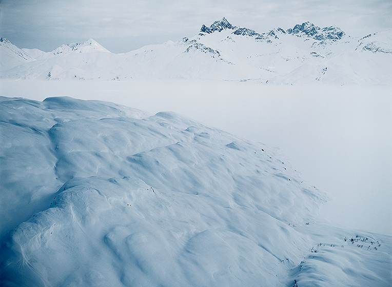
photograph(s) © copyright, ROBERT GLENN KETCHUM, 2017, @RbtGlennKetchum @LittleBearProd @NRDC @OrvisFlyFishing #NoPebbleMine #LittleBearProd
Follow Robert Glenn Ketchum's Photographic Activism Online:
SOCIAL MEDIA by @LittleBearProd: http://www.LittleBearProd.com
_____________________________________________________
Tuesday, August 1, 2017

photograph(s) © copyright, ROBERT GLENN KETCHUM, 2017, @RbtGlennKetchum @LittleBearProd @NRDC @OrvisFlyFishing #NoPebbleMine #LittleBearProd
Follow Robert Glenn Ketchum's Photographic Activism Online:
SOCIAL MEDIA by @LittleBearProd: http://www.LittleBearProd.com
_____________________________________________________
Tuesday, July 25, 2017

photograph(s) © copyright, ROBERT GLENN KETCHUM, 2017, @RbtGlennKetchum @LittleBearProd @NRDC @OrvisFlyFishing #NoPebbleMine #LittleBearProd
Follow Robert Glenn Ketchum's Photographic Activism Online:
SOCIAL MEDIA by @LittleBearProd: http://www.LittleBearProd.com
_____________________________________________________
Tuesday, July 11, 2017

photograph(s) © copyright, ROBERT GLENN KETCHUM, 2017, @RbtGlennKetchum @LittleBearProd @NRDC @OrvisFlyFishing #NoPebbleMine #LittleBearProd
Follow Robert Glenn Ketchum's Photographic Activism Online:
SOCIAL MEDIA by @LittleBearProd: http://www.LittleBearProd.com
_____________________________________________________
Tuesday, July 4, 2017

photograph(s) © copyright, ROBERT GLENN KETCHUM, 2017, @RbtGlennKetchum @LittleBearProd @NRDC @OrvisFlyFishing #NoPebbleMine #LittleBearProd
Follow Robert Glenn Ketchum's Photographic Activism Online:
SOCIAL MEDIA by @LittleBearProd: http://www.LittleBearProd.com
_____________________________________________________
Tuesday, June 27, 2017

photograph(s) © copyright, ROBERT GLENN KETCHUM, 2017, @RbtGlennKetchum @LittleBearProd @NRDC @OrvisFlyFishing #NoPebbleMine #LittleBearProd
Follow Robert Glenn Ketchum's Photographic Activism Online:
SOCIAL MEDIA by @LittleBearProd: http://www.LittleBearProd.com
_____________________________________________________
Tuesday, May 23, 2017

photograph(s) © copyright, ROBERT GLENN KETCHUM, 2017, @RbtGlennKetchum @LittleBearProd @NRDC @OrvisFlyFishing #NoPebbleMine #LittleBearProd
Follow Robert Glenn Ketchum's Photographic Activism Online:
SOCIAL MEDIA by @LittleBearProd: http://www.LittleBearProd.com
_____________________________________________________
Tuesday, May 16, 2017

photograph(s) © copyright, ROBERT GLENN KETCHUM, 2017, @RbtGlennKetchum @LittleBearProd @NRDC @OrvisFlyFishing #NoPebbleMine #LittleBearProd
Follow Robert Glenn Ketchum's Photographic Activism Online:
SOCIAL MEDIA by @LittleBearProd: http://www.LittleBearProd.com
_____________________________________________________
Tuesday, May 9, 2017

photograph(s) © copyright, ROBERT GLENN KETCHUM, 2017, @RbtGlennKetchum @LittleBearProd @NRDC @OrvisFlyFishing #NoPebbleMine #LittleBearProd
Follow Robert Glenn Ketchum's Photographic Activism Online:
SOCIAL MEDIA by @LittleBearProd: http://www.LittleBearProd.com
_____________________________________________________
Tuesday, May 2, 2017

photograph(s) © copyright, ROBERT GLENN KETCHUM, 2017, @RbtGlennKetchum @LittleBearProd @NRDC @OrvisFlyFishing #NoPebbleMine #LittleBearProd
Follow Robert Glenn Ketchum's Photographic Activism Online:
SOCIAL MEDIA by @LittleBearProd: http://www.LittleBearProd.com
_____________________________________________________
Tuesday, April 25, 2017

photograph(s) © copyright, ROBERT GLENN KETCHUM, 2017, @RbtGlennKetchum @LittleBearProd @NRDC @OrvisFlyFishing #NoPebbleMine #LittleBearProd
Follow Robert Glenn Ketchum's Photographic Activism Online:
SOCIAL MEDIA by @LittleBearProd: http://www.LittleBearProd.com
_____________________________________________________
Tuesday, April 18, 2017

photograph(s) © copyright, ROBERT GLENN KETCHUM, 2017, @RbtGlennKetchum @LittleBearProd @NRDC @OrvisFlyFishing #NoPebbleMine #LittleBearProd
Follow Robert Glenn Ketchum's Photographic Activism Online:
SOCIAL MEDIA by @LittleBearProd: http://www.LittleBearProd.com
_____________________________________________________
Tuesday, April 11, 2017

photograph(s) © copyright, ROBERT GLENN KETCHUM, 2017, @RbtGlennKetchum @LittleBearProd @NRDC @OrvisFlyFishing #NoPebbleMine #LittleBearProd
Follow Robert Glenn Ketchum's Photographic Activism Online:
SOCIAL MEDIA by @LittleBearProd: http://www.LittleBearProd.com
_____________________________________________________
Tuesday, April 4, 2017

photograph(s) © copyright, ROBERT GLENN KETCHUM, 2017, @RbtGlennKetchum @LittleBearProd @NRDC @OrvisFlyFishing #NoPebbleMine #LittleBearProd
Follow Robert Glenn Ketchum's Photographic Activism Online:
SOCIAL MEDIA by @LittleBearProd: http://www.LittleBearProd.com
_____________________________________________________
Tuesday, March 28, 2017

photograph(s) © copyright, ROBERT GLENN KETCHUM, 2017, @RbtGlennKetchum @LittleBearProd @NRDC @OrvisFlyFishing #NoPebbleMine #LittleBearProd
Follow Robert Glenn Ketchum's Photographic Activism Online:
SOCIAL MEDIA by @LittleBearProd: http://www.LittleBearProd.com
_____________________________________________________
Tuesday, March 21, 2017

photograph(s) © copyright, ROBERT GLENN KETCHUM, 2017, @RbtGlennKetchum @LittleBearProd @NRDC @OrvisFlyFishing #NoPebbleMine #LittleBearProd
Follow Robert Glenn Ketchum's Photographic Activism Online:
SOCIAL MEDIA by @LittleBearProd: http://www.LittleBearProd.com
_____________________________________________________
Tuesday, March 14, 2017

photograph(s) © copyright, ROBERT GLENN KETCHUM, 2017, @RbtGlennKetchum @LittleBearProd @NRDC @OrvisFlyFishing #NoPebbleMine #LittleBearProd
Follow Robert Glenn Ketchum's Photographic Activism Online:
SOCIAL MEDIA by @LittleBearProd: http://www.LittleBearProd.com
_____________________________________________________
Tuesday, March 7, 2017

photograph(s) © copyright, ROBERT GLENN KETCHUM, 2017, @RbtGlennKetchum @LittleBearProd @NRDC @OrvisFlyFishing #NoPebbleMine #LittleBearProd
Follow Robert Glenn Ketchum's Photographic Activism Online:
SOCIAL MEDIA by @LittleBearProd: http://www.LittleBearProd.com
_____________________________________________________
Tuesday, February 28, 2017

photograph(s) © copyright, ROBERT GLENN KETCHUM, 2017, @RbtGlennKetchum @LittleBearProd @NRDC @OrvisFlyFishing #NoPebbleMine #LittleBearProd
Follow Robert Glenn Ketchum's Photographic Activism Online:
SOCIAL MEDIA by @LittleBearProd: http://www.LittleBearProd.com
_____________________________________________________
Tuesday, February 21, 2017

photograph(s) © copyright, ROBERT GLENN KETCHUM, 2017, @RbtGlennKetchum @LittleBearProd @NRDC @OrvisFlyFishing #NoPebbleMine #LittleBearProd
Follow Robert Glenn Ketchum's Photographic Activism Online:
SOCIAL MEDIA by @LittleBearProd: http://www.LittleBearProd.com
_____________________________________________________
Tuesday, February 14, 2017

photograph(s) © copyright, ROBERT GLENN KETCHUM, 2017, @RbtGlennKetchum @LittleBearProd @NRDC @OrvisFlyFishing #NoPebbleMine #LittleBearProd
Follow Robert Glenn Ketchum's Photographic Activism Online:
SOCIAL MEDIA by @LittleBearProd: http://www.LittleBearProd.com
_____________________________________________________
Tuesday, February 7, 2017

photograph(s) © copyright, ROBERT GLENN KETCHUM, 2017, @RbtGlennKetchum @LittleBearProd @NRDC @OrvisFlyFishing #NoPebbleMine #LittleBearProd
Follow Robert Glenn Ketchum's Photographic Activism Online:
SOCIAL MEDIA by @LittleBearProd: http://www.LittleBearProd.com
_____________________________________________________
Tuesday, January 31, 2017

photograph(s) © copyright, ROBERT GLENN KETCHUM, 2017, @RbtGlennKetchum @LittleBearProd @NRDC @OrvisFlyFishing #NoPebbleMine #LittleBearProd
Follow Robert Glenn Ketchum's Photographic Activism Online:
SOCIAL MEDIA by @LittleBearProd: http://www.LittleBearProd.com
_____________________________________________________
Tuesday, January 24, 2017

photograph(s) © copyright, ROBERT GLENN KETCHUM, 2017, @RbtGlennKetchum @LittleBearProd @NRDC @OrvisFlyFishing #NoPebbleMine #LittleBearProd
Follow Robert Glenn Ketchum's Photographic Activism Online:
SOCIAL MEDIA by @LittleBearProd: http://www.LittleBearProd.com
_____________________________________________________
Tuesday, January 17, 2017

photograph(s) © copyright, ROBERT GLENN KETCHUM, 2017, @RbtGlennKetchum @LittleBearProd @NRDC @OrvisFlyFishing #NoPebbleMine #LittleBearProd
Follow Robert Glenn Ketchum's Photographic Activism Online:
SOCIAL MEDIA by @LittleBearProd: http://www.LittleBearProd.com
_____________________________________________________
Tuesday, January 10, 2017

photograph(s) © copyright, ROBERT GLENN KETCHUM, 2017, @RbtGlennKetchum @LittleBearProd @NRDC @OrvisFlyFishing #NoPebbleMine #LittleBearProd
Follow Robert Glenn Ketchum's Photographic Activism Online:
SOCIAL MEDIA by @LittleBearProd: http://www.LittleBearProd.com
_____________________________________________________
Tuesday, January 3, 2017

photograph(s) © copyright, ROBERT GLENN KETCHUM, 2017, @RbtGlennKetchum @LittleBearProd @NRDC @OrvisFlyFishing #NoPebbleMine #LittleBearProd
Follow Robert Glenn Ketchum's Photographic Activism Online:
SOCIAL MEDIA by @LittleBearProd: http://www.LittleBearProd.com
_____________________________________________________
Tuesday, December 27, 2016

photograph(s) © copyright, ROBERT GLENN KETCHUM, 2016, @RbtGlennKetchum @LittleBearProd @NRDC @OrvisFlyFishing #NoPebbleMine #LittleBearProd
Follow Robert Glenn Ketchum's Photographic Activism Online:
SOCIAL MEDIA by @LittleBearProd: http://www.LittleBearProd.com
_____________________________________________________
Tuesday, December 13, 2016
Tuesday, December 13, 2016

photograph(s) © copyright, ROBERT GLENN KETCHUM, 2016, @RbtGlennKetchum @LittleBearProd @NRDC @OrvisFlyFishing #NoPebbleMine #LittleBearProd
Follow Robert Glenn Ketchum's Photographic Activism Online:
SOCIAL MEDIA by @LittleBearProd: http://www.LittleBearProd.com
_____________________________________________________

NO PEBBLE MINE #221, Pictures from Ground Zero: NO PEBBLE MINE #221: Most of the images I have posted so far of Wood-Tikchik State Park have been of areas east and south of my base at the Tikchik Narrows Lodge. Now flying to the north and looking east we are above numerous smaller lakes in a tundra and dense scrub-covered landscape, and the mountains are fewer, further between, more rounded and vegetated. This is BIG terrain with little reference for scale, so try the stand of large trees in their fall foliage in the middle-left of this image. In the opposite direction, to the west, it is an entirely different view as you will see next week. Under our other wing are the last of the big lakes and they nestle at the base of mountains, whose valleys and canyons open into some very dramatic backcountry we will explore.
photograph(s) © copyright, ROBERT GLENN KETCHUM, 2016, @RbtGlennKetchum @LittleBearProd @NRDC @OrvisFlyFishing #NoPebbleMine #LittleBearProd
Follow Robert Glenn Ketchum's Photographic Activism Online:
SOCIAL MEDIA by @LittleBearProd: http://www.LittleBearProd.com
_____________________________________________________
Tuesday, November 29, 2016

NO PEBBLE MINE #220, Pictures from Ground Zero: NO PEBBLE MINE #220, Pictures from Ground Zero: The anglers have arisen at Tikchik Narrows Lodge, but no one is going anywhere just yet. Those same diurnal fogs that occur over the saturated tundra, which I showed you in post #184, also occur over the lakes. When I first awoke, there was NO visibility whatsoever. Now the landscape is slowly beginning to emerge, and with a leisurely breakfast to occupy our time, all of this will be burned off fairly soon. The planes will go out, and we might well have a sunny, warm day. The next flight loop we will take from the lodge will carry us over the big lakes not yet visited and up to the edge of the backcountry leading into the Wood River Mountains. This is some of the most spectacular landscape I have EVER flown over, so I hope you will continue to follow this blog. I also hope you will continue to say NO TO THE PEBBLE MINE - given our recent election, PLEASE WRITE PRESIDENT OBAMA NOW AND ASK HIM TO PROTECT SOUTHWEST ALASKA AND BRISTOL BAY PERMANENTLY FROM MINING AND INDUSTRIAL DEVELOPMENT before he leaves office.
photograph(s) © copyright, ROBERT GLENN KETCHUM, 2016, @RbtGlennKetchum @LittleBearProd @NRDC @OrvisFlyFishing #NoPebbleMine #LittleBearProd
Follow Robert Glenn Ketchum's Photographic Activism Online:
SOCIAL MEDIA by @LittleBearProd: http://www.LittleBearProd.com
_____________________________________________________
Tuesday, November 22, 2016

NO PEBBLE MINE #219, Pictures from Ground Zero: NO PEBBLE MINE #219, Pictures from Ground Zero: I am going to explore the other big lakes, but for the moment have circled back toward Tikchik Narrows Lodge that I am using as my base. In post #204, I showed you this group of distinctly shaped, stone-faced summits and promised you would see them again in a different light, or in this case, almost no light. Not every day of flying is perfect flight-seeing, and this is one of those. We are being chased “home” by blinding rain and a lowering ceiling. Visibility will be zero soon. My pilot has been flying for the lodge for years and is not concerned. We have followed a river to a low valley at the end of which these domes loomed, sentinel-like. And they were indeed sentinels as they mark the western shore of Tikchik Lake. Now, whether we can see it or not, we just turn left at the first dome, fly past the faces of the others in the line, and the lodge will appear quite soon out the window on our right. I once had a pilot who was flying me in a terrible storm with almost no visibility, tell me not to worry because he had IFR. When I asked what that was, he said, “I follow rivers."
photograph(s) © copyright, ROBERT GLENN KETCHUM, 2016, @RbtGlennKetchum @LittleBearProd @NRDC @OrvisFlyFishing #NoPebbleMine #LittleBearProd
Follow Robert Glenn Ketchum's Photographic Activism Online:
SOCIAL MEDIA by @LittleBearProd: http://www.LittleBearProd.com
_____________________________________________________
Tuesday, November 15, 2016

NO PEBBLE MINE #218, Pictures from Ground Zero: NO PEBBLE MINE #218, Pictures from Ground Zero: The bears and the cold water may have prevented my approach of this canyon on foot, but to see it helps to understand the ruggedness of the Wood River Mountains so this is an aerial of that terrain. As I said in the last post, the canyon is narrow, surrounded by steep walls and crowned with glaciers, two of which you see here. The meltwater from them creates the pale blue colors you saw in the last post. These summits in many cases have experienced glaciation on all sides, leaving them with ragged spires and knife-thin ridgelines like this one below the wing. Note also how deep the canyon has been carved and consider that when this glacier reached the plane of Nuyakuk Lake, it gouged out another 900ft. of depth. At some point in geologic time, there was A LOT OF ICE covering everything you and I now see.
photograph(s) © copyright, ROBERT GLENN KETCHUM, 2016, @RbtGlennKetchum @LittleBearProd @NRDC @OrvisFlyFishing #NoPebbleMine #LittleBearProd
Follow Robert Glenn Ketchum's Photographic Activism Online:
SOCIAL MEDIA by @LittleBearProd: http://www.LittleBearProd.com
_____________________________________________________
Tuesday, November 15, 2016 
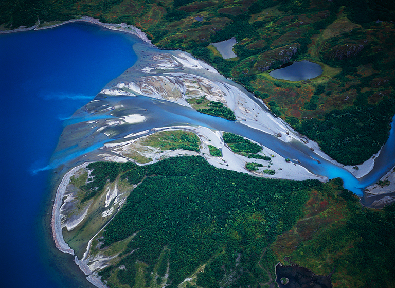
NO PEBBLE MINE #217, Pictures from Ground Zero: NO PEBBLE MINE #217, Pictures from Ground Zero: In the last post you are looking at a portion of Mirror Bay at the far western end of Nuyakuk Lake in Wood-Tikchik State Park. This is another portion of it. Pure glacial meltwater (pale blue) pours into the lake from the summits above. The canyon this river comes out of is narrow and spectacular, terminating in steep walls crowned with glaciers that stream waterfalls down on to the rocks below. I have approached this beach and walked on the sandbar. For a time, there was actually some consideration of trying to “walk the river” and go back into the canyon. Three things discouraged that from happening: the water is stunningly cold; there are too many deep holes to get around; AND a mother grizzly with two cubs showed up on the beach where the river doglegs (center, right) just as we approached. Collectively those seemed to be signs to get back in the boat and consider some other adventure.
photograph(s) © copyright, ROBERT GLENN KETCHUM, 2016, @RbtGlennKetchum @LittleBearProd @NRDC @OrvisFlyFishing #NoPebbleMine #LittleBearProd
Follow Robert Glenn Ketchum's Photographic Activism Online:
SOCIAL MEDIA by @LittleBearProd: http://www.LittleBearProd.com
_____________________________________________________
Tuesday, November 1, 2016

NO PEBBLE MINE #216, Pictures from Ground Zero: NO PEBBLE MINE #216, Pictures from Ground Zero: Nuyakuk Lake is the largest of the Wood-Tikchik lakes in both breadth and a length of over 40 miles. It is one of the deepest lakes in all of Alaska as well. At the western end of the lake it narrows between steep summits and divides into Mirror Bay and Portage Arm. I have flown over, boated in, and come on snowmobile during winter to this part of the park, and besides the possibility of a Loch Ness-type creature living in the lake, when I am at this end of Nuyakuk, I have always had a sense of the primeval, as though I had found a "lost" world. This is Mirror Bay glowing under breaking sunlight. Those are nice beaches in the upper right, but you would want to be armed. For some reason, I think a photographic POV, I actually scaled the brush cliff face to reach the small lake (lower, right). I would NOT recommend that as a good idea. Once you are off the beach here, it is serious thrash. Best to keep your boots on and walk the shallows of the rivers if you expect to go anywhere.
photograph(s) © copyright, ROBERT GLENN KETCHUM, 2016, @RbtGlennKetchum @LittleBearProd @NRDC @OrvisFlyFishing #NoPebbleMine #LittleBearProd
Follow Robert Glenn Ketchum's Photographic Activism Online:
SOCIAL MEDIA by @LittleBearProd: http://www.LittleBearProd.com
_____________________________________________________
Tuesday, October 25, 2016

NO PEBBLE MINE #215, Pictures from Ground Zero: NO PEBBLE MINE #215, Pictures from Ground Zero: A slightly more overhead perspective offers another dramatic viewpoint when you are flying over the big lakes in Wood-Tikchik Sate Park. As I have noted, these lakes are glacially carved and deep, like a coastal fjord. They are also STUNNINGLY CLEAR! With no glare on the water, you can see into the depths. This is Nuyakuk, over 60 miles in length, and measured at more than 940ft deep. In fact, in places, the sonar echo mapping the bottom did NOT rebound - bottomless? There are locals who believe there is a creature in this lake that when described, sounds very much like the Loch Ness Monster. I thought about this many times when I was in a small boat on these waters AND I had a very strange vibe about what lay beneath the frozen lake surface when I was crossing it on a snow machine one winter. If you have been reading this blog, you know I reference the scale of things all the time, so let's try one here: go to the middle of the curve on the perfect crescent beach. From that point, draw a line to the upper, right corner of this image. As your imaginary line starts inland and passes through the trees, you can see a bright rectangle that stands out at the edge of the forest - that is a United States Forest Service cabin that sleeps 8, and is maintained for those who hunt and kayak in the park. Follow the shoreline around the crescent and the peninsula, moving toward the lower, right of the frame. In the middle of this long beach there is a large clump of green bushes, followed (moving right) by an arc in the sand that seems to have an orange dot in the middle of it - that dot is a decently sized boat that carried 4hunters and all their gear into the cabin. If you are wondering what a walk on this beach is like, it IS fantastic, but best to do it armed as both moose and bear also enjoy the stroll.
photograph(s) © copyright, ROBERT GLENN KETCHUM, 2016, @RbtGlennKetchum @LittleBearProd @NRDC @OrvisFlyFishing #NoPebbleMine #LittleBearProd
Follow Robert Glenn Ketchum's Photographic Activism Online:
SOCIAL MEDIA by @LittleBearProd: http://www.LittleBearProd.com
_____________________________________________________
Tuesday, October 18, 2016

NO PEBBLE MINE #214, Pictures from Ground Zero: NO PEBBLE MINE #214, Pictures from Ground Zero: The glaciation that created the "large lake" section of Wood-Tikchik State Park, also established another dynamic. As you perhaps noticed in previous posts #198 & #199, the eastern end of the lakes face out into hills and a flatter landscape, making the lakes often a mirror of the sky which is constantly churning with weather from Bristol Bay and the Bering Sea. In a westerly direction, the lakes mirror the rising Wood River Mountains and you begin to sense the fact that these ARE alpine fjords, with the rugged mountains now part of the reflective surface. The beauty of seeing all of this from the air is that you sometimes get it all of at once, as is happening here. Some of these lakes reach 60-miles in length, and flying by them watching the spectacle of forms shimmer and float by under the wing, everyone I ever flew with fell silent and just stared in awe, with an occasional, "Oh my God!"
photograph(s) © copyright, ROBERT GLENN KETCHUM, 2016, @RbtGlennKetchum @LittleBearProd @NRDC @OrvisFlyFishing #NoPebbleMine #LittleBearProd
Follow Robert Glenn Ketchum's Photographic Activism Online:
SOCIAL MEDIA by @LittleBearProd: http://www.LittleBearProd.com
_____________________________________________________
Tuesday, October 11, 2016

NO PEBBLE MINE #213, Pictures from Ground Zero: NO PEBBLE MINE #213 Pictures from Ground Zero: The foothills featured in the last few posts are the lower flanks of a significant range of mountains whose summits face directly into the terrible winter weather of the Bering Sea. In geologic history this range accumulated massive amounts of snow, generating numerous glaciers. Those glaciers descended from the summits into the lowlands and foothills that my previous posts featured. A succession of one glacier after another flowed down the east side of the range, cutting deeply into the landscape and carving a series of long relatively parallel tracks across the "flats." When the ice retreated, meltwater and rainfall filled the deep cuts and created the lake chain that is the heart of Wood-Tikchik State Park. This map makes all that very clear. The Wood Mountains are to the left, the "ladder" of lakes were formally glaciers. I have always loved words, and some of the words/names that arise from Southwest AK culture are just amazing - check some of these lake names. Beginning at the bottom and rising, just outside the boundaries of the park are Nunavaugaluk and Aleknagik, then, two arms of Lake Nerka, followed by Beverly, Kulik, Nuyakuk-Tikchik, Chauekuktuli, Chikuminuk, Upnuk, Slate, and Nishlik. YEOW!
photograph(s) © copyright, ROBERT GLENN KETCHUM, 2016, @RbtGlennKetchum @LittleBearProd @NRDC @OrvisFlyFishing #NoPebbleMine #LittleBearProd
Follow Robert Glenn Ketchum's Photographic Activism Online:
SOCIAL MEDIA by @LittleBearProd: http://www.LittleBearProd.com
_____________________________________________________
Tuesday, October 4, 2016

NO PEBBLE MINE #212, Pictures from Ground Zero: NO PEBBLE MINE #212 Pictures from Ground Zero: Another section of Wood-Tikchik State Park that is very unique is a group of hills and valleys similar to the previous 2 posts, except these hills and valleys have little shrubbery and are mostly covered by patches of tundra. These are the Red Hills. Because they are exposed, and host little mounds of rock amidst the tundra, these rock "islands" offer "territory" and a clear line-of-site in all directions for male moose that are trying to mate. As fall and the rutting season arrive, moose migrate here from all over the park to stake out a mound, snorting, stomping, and shaking their racks in threatening ways to claim "their" territory. On one of my many flights over this part of the park, it was season-of-the-moose, and they were everywhere. My pilot commented these were all "young and angry" and ready to take on anything threatening their territory. With that he took the plane VERY low and came up on a moose knoll with a resident. I have NEVER seen an animal that does not flee from a low flying aircraft, but this moose stood its ground, shook its head, and POPPED UP ON HIS HIND FEET as we flew over, CHALLENGING the plane, not fleeing.
photograph(s) © copyright, ROBERT GLENN KETCHUM, 2016, @RbtGlennKetchum @LittleBearProd @NRDC @OrvisFlyFishing #NoPebbleMine #LittleBearProd
Follow Robert Glenn Ketchum's Photographic Activism Online:
SOCIAL MEDIA by @LittleBearProd: http://www.LittleBearProd.com
_____________________________________________________

NO PEBBLE MINE #211, Pictures from Ground Zero: NO PEBBLE MINE #211 Pictures from Ground Zero: Such dense vegetation may be tough to travel through, but it is an incredible water trap. Look how this valley and foothills are literally swallowed by growth. There are dozens of rivers and streams here and you can hardly see one of them. Careful study, however, reveals the magic of this fish-rich watershed. Not only does the "bush" trap water from passing weather, it filters it, and channels it downward into innumerable small drainages - I count at least 22 here. In turn, their waters merge in the valley to form a stream that will soon connect again further down, creating a river. Water, water, everywhere! Unpolluted and teeming with life. More living things are sustained on land as well, BUT if you disrupt THE HABITAT which clearly includes clean air and water quality, you change everything over time and it will all go away. SAY NO TO THE PEBBLE MINE!
photograph(s) © copyright, ROBERT GLENN KETCHUM, 2016, @RbtGlennKetchum @LittleBearProd @NRDC @OrvisFlyFishing #NoPebbleMine #LittleBearProd
Follow Robert Glenn Ketchum's Photographic Activism Online:
SOCIAL MEDIA by @LittleBearProd: http://www.LittleBearProd.com
_____________________________________________________
Tuesday, September 20, 2016

NO PEBBLE MINE #210, Pictures from Ground Zero: NO PEBBLE MINE #210 Pictures from Ground Zero: On this morning's news I heard that 10% of ALL the wilderness in the world had been lost since 1990. This is NOT good news for the health of the planetary ecosystem. Alaskans often complain about federal control and too much DESIGNATED wilderness, but history seems to show a human willingness to disrupt and eliminate wilderness if is NOT intentionally protected. I personally think Alaskans are lucky to have so much. I am also proud that my work has helped to create wilderness: my TONGASS BLOG; my TATSHENSHINI BLOG; celebrate it: my TRACY ARM BLOG; and defend it: my NO PEBBLE BLOG. Part of the wonder of Wood-Tikchik State Park for me is the "wilderness" of it. I can SEE it. Without being any particularly notable place or summit, this entire landscape seethes with wildness thriving in wilderness. American naturalist, hiker, and author, Edward Abbey once said that you do not know wilderness until you enter the food chain. Well, welcome to Alaska! This may look beautiful but I assure you it is rugged thrash and you would be crazy not be armed.
photograph(s) © copyright, ROBERT GLENN KETCHUM, 2016, @RbtGlennKetchum @LittleBearProd @NRDC @OrvisFlyFishing #NoPebbleMine #LittleBearProd
Follow Robert Glenn Ketchum's Photographic Activism Online:
SOCIAL MEDIA by @LittleBearProd: http://www.LittleBearProd.com
_____________________________________________________
Tuesday, September 13, 2016

NO PEBBLE MINE #209, Pictures from Ground Zero: NO PEBBLE MINE #209 Pictures from Ground Zero: I am NOT making this stuff up! Welcome to PEAK fall in Wood-Tikchik State Park. Flying in the foothills of the park during the VERY brief (10 days) fall season, is one of the most dazzling landscapes I have ever viewed. As the season brings on-and-off rain on nearly a daily basis, the saturated landscape sparkles and glows in the spots of sunlight between the clouds. This is JUST some swampy, anonymous valley (LOL). As you will see in the posts to come, when we move into the higher elevations around the big lakes, this spectacle becomes even more ridiculous. Does terrain like this look like a good place to put the largest open-pit mine to ever be constructed? WHAT? Just so NO!
photograph(s) © copyright, ROBERT GLENN KETCHUM, 2016, @RbtGlennKetchum @LittleBearProd @NRDC @OrvisFlyFishing #NoPebbleMine #LittleBearProd
Follow Robert Glenn Ketchum's Photographic Activism Online:
SOCIAL MEDIA by @LittleBearProd: http://www.LittleBearProd.com
_____________________________________________________
Tuesday, September 6, 2016

NO PEBBLE MINE #208, Pictures from Ground Zero: NO PEBBLE MINE #208, Pictures from Ground Zero: Wood-Tikchik State Park takes a LOT of weather coming in off the Bering Sea and Bristol Bay. Many days flying around the park look like this, but although gray and stormy, when I look down on this landscape, I see extraordinary lushness - a world THRIVING in water, indeed, fed by the water. Lakes, rivers, streams, fish, bear, wolves, caribou, and all the others, thriving in one of the last and least undisturbed ecosystems of this scale in North America. Why would Americans allow an international corporation and international investors to, quite literally, POISON this place? Last week, in a HUGE moment for the NO PEBBLE MINE campaign, the International Union for the Conservation of Nature (IUCN) approved of this motion which will hopefully provide the final impetus for the EPA and President Obama to protect the valuable RENEWABLE resources of southwest Alaska and Bristol Bay. Please write to the president and ask him to say NO TO THE PEBBLE MINE and to recognize this entire area as one of the greatest biological reserves ON THE PLANET!
photograph(s) © copyright, ROBERT GLENN KETCHUM, 2016, @RbtGlennKetchum @LittleBearProd @NRDC @OrvisFlyFishing #NoPebbleMine #LittleBearProd
Follow Robert Glenn Ketchum's Photographic Activism Online:
SOCIAL MEDIA by @LittleBearProd: http://www.LittleBearProd.com
_____________________________________________________
Tuesday, August 30, 2016

NO PEBBLE MINE #207, Pictures from Ground Zero: NO PEBBLE MINE #207, Pictures from Ground Zero: This section of Wood-Tikchik Sate Park has mountains but they do not rise as steeply or as high as those in the heart of the range. There are forests here as well, but the tundra-spruce environment gives way to significant stands of deciduous trees around the rivers where water is plentiful. These seasonal trees not only provide fall color, but moose browse them all year round, and in the summer they are cover from heat and hunters for both moose and bear. The rising terrain channels water down virtually EVERY valley, coalescing in the lake system. In this image you can see two rivers coming in from the top of the frame and then joining to form the larger one in the foreground. Those are some REALLY dense stands of cottonwood, surrounded by swampy tundra. Once again, tough territory to cover on foot.
photograph(s) © copyright, ROBERT GLENN KETCHUM, 2016, @RbtGlennKetchum @LittleBearProd @NRDC @OrvisFlyFishing #NoPebbleMine #LittleBearProd
Follow Robert Glenn Ketchum's Photographic Activism Online:
SOCIAL MEDIA by @LittleBearProd: http://www.LittleBearProd.com
_____________________________________________________
Tuesday, August 23, 2016
Tuesday, August 23, 2016

NO PEBBLE MINE #206, Pictures from Ground Zero: NO PEBBLE MINE #206, Pictures from Ground Zero: In this part of the park the lakes and meandering streams coalesce into a spectacular falls that is basically a headwater of the Nushagak river. These falls are one of the spectacular fishing destinations accessed by Tikchik Narrows Lodge and its guests. Salmon migrations coming out of Bristol Bay reach the upper lakes in the park through the Nushagak and its supporting streams and rivers. This is also some of the most whitewater you will see on any of the larger rivers in Southwest, as most flow broad and flat, with occasional rocks but seldom having a dramatic sections such as this. Now we will turn west, visiting some of the large lower lakes and valleys before we circle back to the lodge.
photograph(s) © copyright, ROBERT GLENN KETCHUM, 2016, @RbtGlennKetchum @LittleBearProd @NRDC @OrvisFlyFishing #NoPebbleMine #LittleBearProd
Follow Robert Glenn Ketchum's Photographic Activism Online:
SOCIAL MEDIA by @LittleBearProd: http://www.LittleBearProd.com
_____________________________________________________
Tuesday, August 16, 2016

NO PEBBLE MINE #205, Pictures from Ground Zero: NO PEBBLE MINE #205, Pictures from Ground Zero: Because it is less mountainous, the rolling hills and valleys at the lower end of the Wood-Tikchik State Park harbor a number of rivers significant to the Bristol Bay fishery. Largest among these are the Agulupak and the Agulowak and if you bother to read this link, I am happy to say that my books were a catalyst in bringing these many funders together and some of them are still "partners" (Orvis, Tiffany & Co.) of mine in the ongoing NO PEBBLE MINE campaign. Those two rivers, however, share this fish-rich landscape with dozens of "lesser" river systems, and here you see a beautiful "creek" meandering aimlessly across a valley bottom. In Alaska, floating and fishing an environment like this provides an unparalleled wilderness experience, unlike any other I have ever had.
photograph(s) © copyright, ROBERT GLENN KETCHUM, 2016, @RbtGlennKetchum @LittleBearProd @NRDC @OrvisFlyFishing #NoPebbleMine #LittleBearProd
Follow Robert Glenn Ketchum's Photographic Activism Online:
SOCIAL MEDIA by @LittleBearProd: http://www.LittleBearProd.com
_____________________________________________________
Tuesday, August 9, 2016

NO PEBBLE MINE #204, Pictures from Ground Zero: NO PEBBLE MINE #204, Pictures from Ground Zero: At the far end of the lake, flying east from Tikchik Narrows Lodge, you pass several rolling summits that have a sheer rock face on one side. These faces are a signature in the landscape and we will fly over and around them in a number of weather conditions trying to navigate guest commutes and my flight-shooting back and forth between the lodge and fishing locations at the lower end of the park. I will also visit the lodge and the park in winter, and thanks to Bud Hodson, who owns and operates the lodge, I had access to a snowmobile, and a winter pilot. One day on the snowmobile I summited the hill/face to the right by approaching from the more gently sloping backside. If this image seems familiar, you may have previously seen it on the cover of my second book about southwest Alaska and Bristol Bay, "Wood-Tikchik: Alaska's Largest State Park".
photograph(s) © copyright, ROBERT GLENN KETCHUM, 2016, @RbtGlennKetchum @LittleBearProd @NRDC @OrvisFlyFishing #NoPebbleMine #LittleBearProd
Follow Robert Glenn Ketchum's Photographic Activism Online:
SOCIAL MEDIA by @LittleBearProd: http://www.LittleBearProd.com
_____________________________________________________
Tuesday, August 2, 2016

NO PEBBLE MINE #203, Pictures from Ground Zero: NO PEBBLE MINE #203, Pictures from Ground Zero: When guests come to Tikchik Narrows Lodge, they fly from Anchorage to Dillingham, a small city at the edge of Bristol Bay that is home to about 3,000 people. Guests will be picked up in Dillingham by the fleet of planes owned by Tikchik Lodge and flown into the park and the narrows. Each day 3 guests and a guide will be assigned a pilot and a destination to which they will fly and fish all day, the planes returning for them in the late afternoon. Each day presents a new destination, and in fact, some greatly varied terrain. Nearest the lodge the mountains are more like burly hills and prominent landscape is tundra, forests, lakes, and streams, ALL of which you can see here. Those trails in the tundra are from bear, moose, caribou, and wolves. There is NO PEBBLE MINE and we should keep it that way.
photograph(s) © copyright, ROBERT GLENN KETCHUM, 2016, @RbtGlennKetchum @LittleBearProd @NRDC @OrvisFlyFishing #NoPebbleMine #LittleBearProd
Follow Robert Glenn Ketchum's Photographic Activism Online:
SOCIAL MEDIA by @LittleBearProd: http://www.LittleBearProd.com
_____________________________________________________
Tuesday, July 26, 2016

NO PEBBLE MINE #202, Pictures from Ground Zero: NO PEBBLE MINE #202, Pictures from Ground Zero: The transition of the light from the top to the mountain to the shore of Tikchik Narrows took less than a minute. During that time the only sounds that could be heard were water noises and the click of my shutter. While it may be true that the sunset and sunrise are a cliche' subject matter in the world of art and photography, there is NOTHING cliche' about ACTUALLY witnessing a great one. For me they have always been breathtaking, uplifting, and inspirational, something I would like to see a little bit more of in art and photography. Enough with morning prayers! Breakfast is on and we are going flying with guests as they get dropped off at various select fishing locations. What you have seen of Wood-Tikchik State Park so far is really just the beginning. Please buckle your seat belt (especially because I am going to take the door off)!
photograph(s) © copyright, ROBERT GLENN KETCHUM, 2016, @RbtGlennKetchum @LittleBearProd @NRDC @OrvisFlyFishing #NoPebbleMine #LittleBearProd
Follow Robert Glenn Ketchum's Photographic Activism Online:
SOCIAL MEDIA by @LittleBearProd: http://www.LittleBearProd.com
_____________________________________________________